Keywords
land-use change, paddy fields, agriculture land
This article is included in the Research Synergy Foundation gateway.
land-use change, paddy fields, agriculture land
Some of the Sustainable Development Goals (SDGs) are relevant to the issue of land change. In this research, SDGs that are included are: no poverty (SDG 1), zero hunger (SDG 2), sustainable cities and communities,15 responsible consumption, and production (SDG 12).1 Agriculture land use as a source of food for the community is essential. Especially, for Indonesians who consume rice as their daily staple food, therefore, the existence of rice fields has a vital role. Thus, these goals can be achieved if food sustainability is fulfilled.
Determination of the Ciletuh Palabuhanratu area as UNESCO Global Geopark at the beginning of 2018 increased visits by local and foreign tourists to this region. This results in an increase in villas, homestays, cottages which leads to a decrease in agricultural land use in this region. Based on the Central Statistics Agency of Sukabumi Regency’s data during 2011-2016, the area of paddy fields has decreased. In 2011, the area of paddy fields in the Ciemas District was 4,684 Ha, while in 2016, it was reduced to 4,225 Ha.
The research on Land-use change has been widely studied in various countries. Kleiman RE and Erickson DL2 explain the factors influencing landscape change in the USA central watershed. The study showed that the increasing trend in riparian forest areas increased land parcelization at the municipal scale.2 Additionally, this study revealed that the number of cultivated agricultural areas and the number of farmers had decreased. The land had been further divided, and the remaining forest existed only along the rivers. According to this study, the causes of the landscape phenomenon are land-use policies, government programs, agricultural mechanization, and agricultural economics. Rau A-L et al. stated that the drivers of change are human-induced.3
Gupta R4 stated that land-use change is caused by population growth. This study examined the complexity of the dynamics of changes in land use, patterns of urban expansion, and population growth. Some indicators were examined using Geomatica, Erdas, and Arc-GIS software. By using these softwares, they were able to show land changes in three cities in India. The same was also done by Iryadi R and Sadewo MN5 in studying the influence of the existence of the Bali Botanical Gardens in the Bedugul basin using Landsat images.5 Thus, there are a lot of research that use Arc-GIS software to investigate land-use changes based on image data.
One of the researches on the relationship between tourism and settlements was carried out by Lakshmi SR and Shaji TL.6 The findings show the impact of tourism development in Varkala on the coastal environment, including urban sprawl, linear urbanization, environmental degradation, waste, habitat transformation, and changes in the social environment. Moreover, Lanya I et al. indicated that land-use changes happen because of rapid tourism development in Bali.7 GIS showed that land use was reclaimed as vacant land, built areas, annual crops, and settlements. This study stated that sustainable tourism strategies need to be done for tourism development through various environmental assessment tools such as Carrying Capacity Assessment (CCA), Strategic Environmental Assessment (SEA), Environmental Impact Assessment (EIA), and sustainability indicators.
Based on these studies, analysis of changes in land use in an area or city is critical because it has various impacts. It is stated by Zhang X et al.8 that analyzing land change can provide a lot of important information for decision making. Liao H et al.9 stated that Land-use change can be predicted by quantitative and spatial simulation models. In research, changes in land use also need to be reviewed because the research area is a geopark area that functions not only as an attractive area for scientific and technological exploration but also as geotourism. A function of the study area as a tourist area is contrary to the Regional Spatial Planning of the Sukabumi Regency. The Ciemas District, as a research area, has been designated as a center for livestock, fisheries, and agriculture activities, especially rice fields. The increasing tourism activities will threaten agricultural land use in this region. However, Hindersah et al.10 stated that the Ciletuh Geopark, which is a typical tourist attraction has prospects to increase regional income. The functioning paddy fields have become villas, bungalows, restaurants, and other facilities built to support tourism activities. Therefore, for the land to be functionally controlled and tourism activities continue to develop, it is necessary to study efforts to control changes in agricultural land due to the development of tourism activities. This research aims to analyze the supply and demand of people's food needs such as rice. Based on the number of demands, this research analyzed the area of rice fields that had to be maintained, so that community needs were still met. After obtaining the area of paddy fields, the priority areas of rice fields were analyzed so that they were not converted to the development of tourism activities.
In this study, a survey, and data collection from two government institutions, namely the Regional Development Planning Research, and Development Agency of Sukabumi Regency, and the Central Bureau of Statistics of Sukabumi Regency were taken (Figure 1). The data is analyzed to create a Suitability Analysis of Paddy Fields.
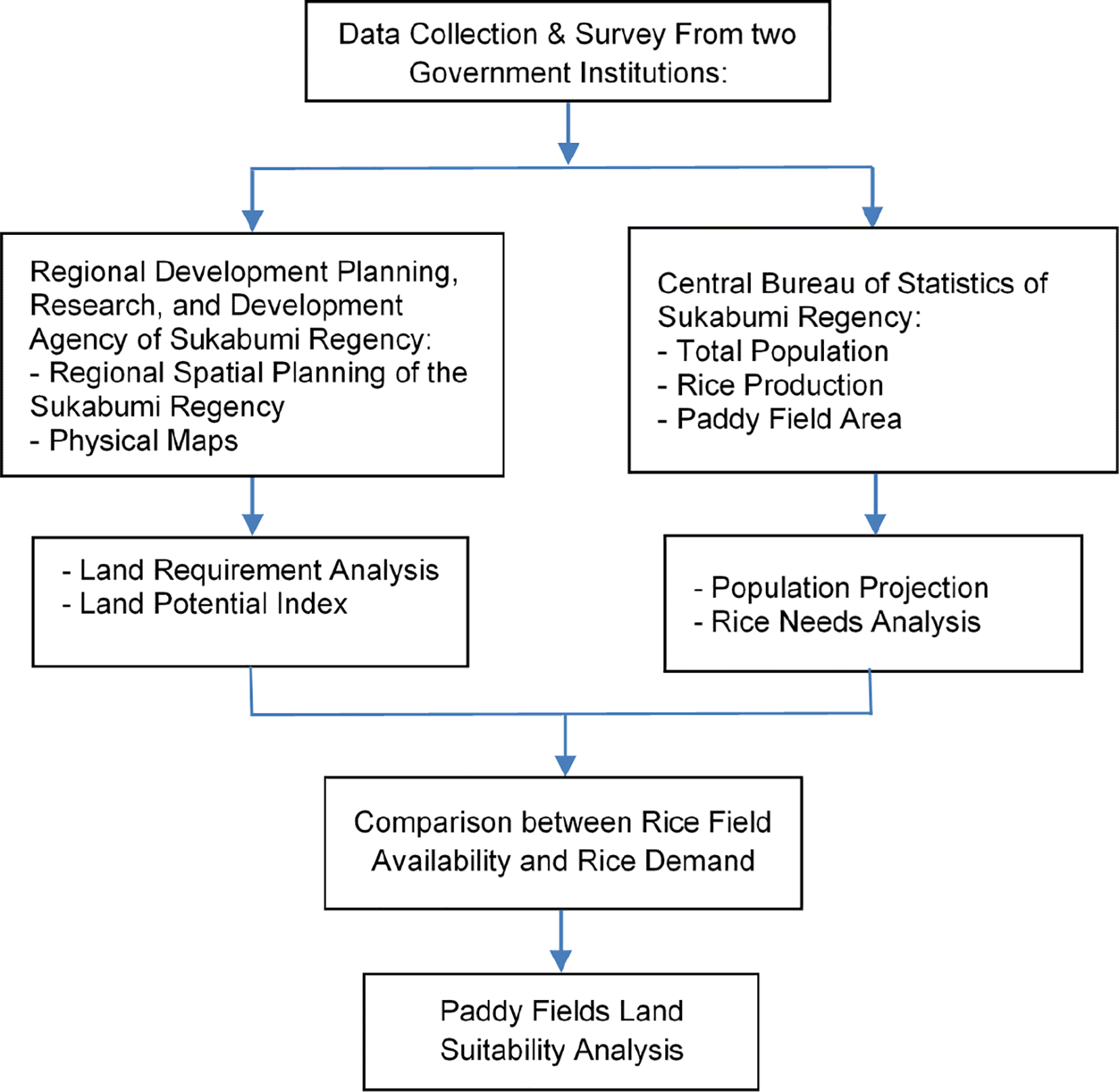
The data needed for this study was collected through secondary data. Secondary data in Landsat images are processed with ARC GIS 10.8 to obtain land use data for physical analysis such as: topographic map, lithological map, soil types of maps, hydrogeological maps, and natural disaster map obtained from Regional Development Planning, Research, and Development of Sukabumi Regency. While population data, paddy fields production, and paddy fields area were obtained from the Central Statistics Agency of Sukabumi Regency (BPS) from 2016 to 2020.11–15
Analysis of paddy field that need to fulfill the community's rice needs is obtained by carrying out the following: first step, calculating future projections of the population to obtain an estimated population in the future using the polynomial method. This method was chosen because the population of the Ciemas District experienced fluctuations. The second step is to calculate the required paddy fields using the following formula.16
LR = land requirements (Acre)
CS = consumption standard (kg/hectare/year)
TP = total population (person)
CCR = coefficient of conversion of rice to paddy (1.918)
ALP = average land production (ton/Ha)
ACI = average cropping index
Gandes H et al.17 said that Analysis of Land Potential Index (LPI) is an analysis to produce land that has the potential to become food agriculture, with assessment parameters in the form of slope, soil type, hydrogeology, lithology, and landslide susceptibility. This analysis technique is carried out by overlaying parameters that have their respective scores to form the LPI class. The LPI class covers very low, medium, high, and very high classes. The formulas used are as follows:
LPI = Land Potential Index
R = Relief
S = Slope
Li = Litology
T = Land Type
H = Hydrogeology
B = Disaster
The suitability analysis of paddy fields was carried out according to FAO (1985)18 evaluation of land for irrigated agriculture. The analysis of delineation of priority paddy field protection aims to delineate which paddy fields have the potential to be protected. This analysis uses parameters in wetland use based on the irrigation, irrigation networks, potential indices of food agriculture, and suitability of wetland paddy fields.
This analysis was carried out by overlaying wetland maps based on the type of irrigation and irrigation networks, with a map of potential agricultural land indexes and a suitability map of rice fields. The conditions for priority paddy fields to be protected are irrigated paddy fields and non-irrigated paddy fields. Those paddy fields have a high to moderate index of food agriculture land potential.
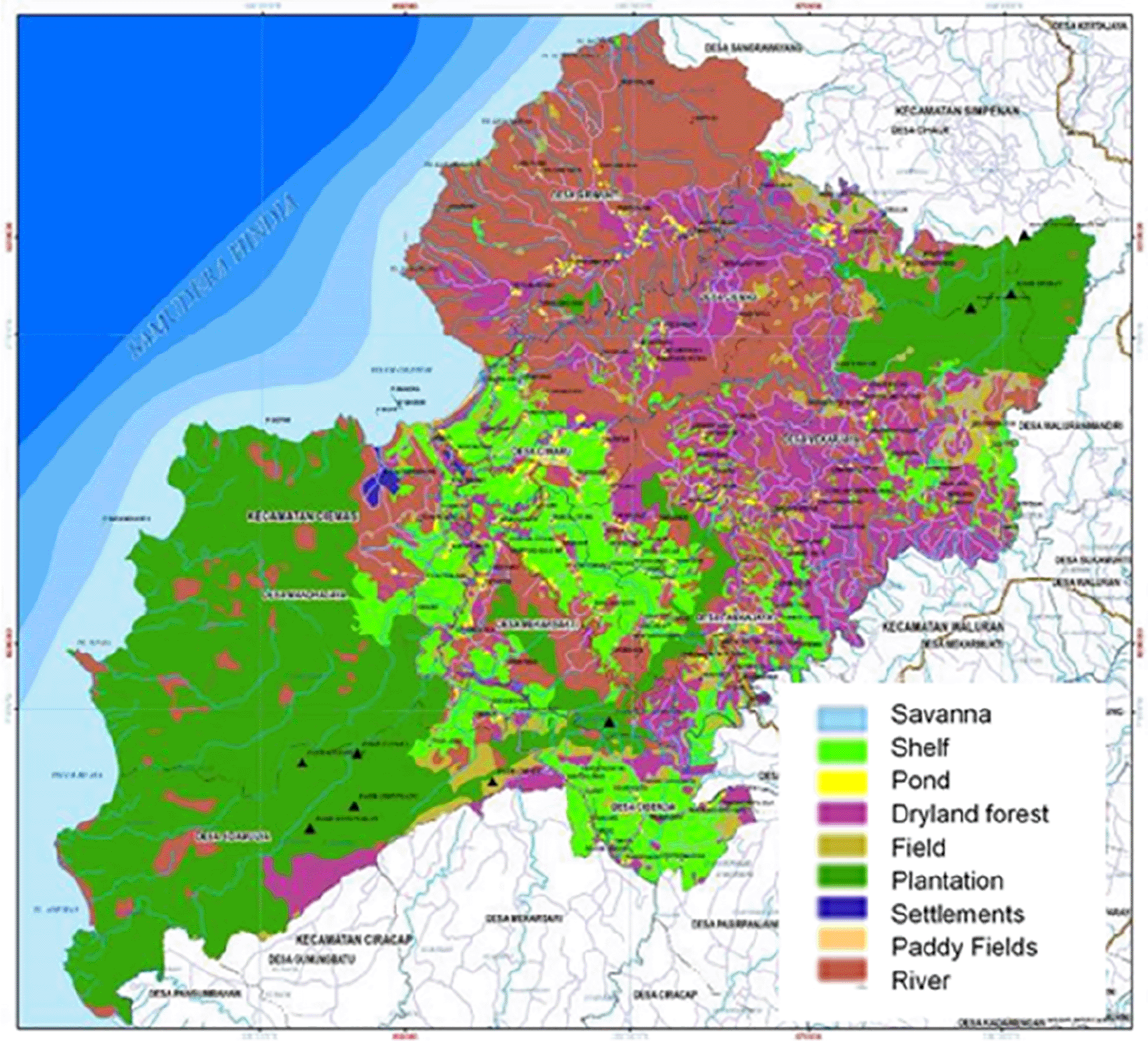
The Ciemas District is one of the regions in West Java, Indonesia. Based on the results of processed SIG from the 2017 Indonesian Earth map, land use in this region (Figure 2) are dryland forests (33%), savannas (29%), plantations (17%), paddy fields (14%), settlement (2%), and others (5%). Based on GIS processing, rice fields in this region in 2017 amounted to 4.276 ha, while paddy fields in 2018 decreased to 4.184 ha (BPS, 2018) [12].
Paddy fields production in the region has fluctuated from year to year because rice cultivation in this area is irrigated and rainfed. Therefore, the intensity of rain dramatically affects the amount of rice production in this region. Based on BPS data [10-15], rice production from 2012 to 2020 can be seen in Table 1.
| Year | Total production of paddy (ton) |
|---|---|
| 2013 | 47,696 |
| 2014 | 45,467 |
| 2015 | 47,996 |
| 2016 | 49,884 |
| 2017 | 41,726 |
| 2018 | 43,664 |
| 2020 | 40,491 |
This area is dominated by farmers. The population from 2011 to 2016 has fluctuated. Table 2. Shows data on the population of the Ciemas District.
| Year | Total population (persons) |
|---|---|
| 2015 | 51,720 |
| 2016 | 51,467 |
| 2017 | 55,349 |
| 2018 | 54,707 |
| 2019 | 54,707 |
To increase rice production in the Ciemas District, the government made 11 irrigation areas, each irrigating the fields with a particular water discharge. The area of paddy fields covered by irrigation is 3,241 ha. The condition of the irrigation canal in the Ciemas District has an average width of 2-3 meters, which is sourced from springs, rivers, and waterfalls. The area of irrigation and water discharge can be seen in Table 3 and the distribution can be seen in Figure 3.

The rice fields that needed to fulfill the community needs can be calculated by projecting the population first (Table 4).
The need for paddy fields per person for the Ciemas Subdistrict community is calculated using formulas 1. Compared to the increase in the estimates of the Ciemas population, the need for paddy fields is also increasing. The rice field needs for the next 20 years has been shown in Table 5, assuming that the actual rice field area in 2016 was 4,225.46 Ha, and it will not decrease until the next 20 years.
| Year | Existing land use (Ha) | Land requirements (Ha) | Surplus/deficit | |
|---|---|---|---|---|
| Large (Ha) | Percentage (%) | |||
| 2025 | 4,225.46 | 1,100.13 | 3,125.33 | 73.96% |
| 2030 | 4,225.46 | 1,137.13 | 3,088.33 | 73.09% |
| 2035 | 4,225.46 | 1,174.13 | 3,051.33 | 72.21% |
Based on Table 5, the needs of paddy fields until the year 2035 could be achieved. The rice field area in Ciemas is surplus. However, the existence of the Ciletuh Geopark as a geotourism area in Ciemas will certainly have an impact on the increasing number of residents who come and turn the land into built-up land for villas, cottages, homestays, and others.
Ciemas District, which functions as one of the sustainable food agriculture areas, must be able to guarantee the availability of food for Ciemas and other regions. Thus, it is necessary to delineate paddy fields that must be protected so that the sustainability of food agriculture in this region is guaranteed. This delineation is carried out by overlaying paddy field maps based on the type of irrigation and irrigation networks, with a map of potential agricultural land indexes and a suitability map of rice fields.
Land Potential Index analysis (LPI)
LPI analysis was carried out scoring from relief, slope, lithology, soil type, hydrogeology, and disaster-prone ground movement. Furthermore, each factor that has been given a score is overlaid to produce 172 types of land, each of which has its own characteristics. Based on the analysis, the classification of the potential of food agriculture, the Ciemas District can be divided into three classes, namely medium, low, and deficient class. The following table are the results of the LPI analysis:
From Table 6 the dominant land of potential food agriculture is the low potential class reaching 68% of total area. The low potential class of land is caused by the main factor of the hydrogeological conditions of the region, where 87.72% of the total area of Ciemas District is included in the minor productive aquifers.
| No | Class | Land potencial classification | Large (Ha) | Percentage (%) |
|---|---|---|---|---|
| 1 | III | Medium | 9,792.59 | 32.00 |
| 2 | IV | Low | 2,.853.26 | 68.00 |
| 3 | V | Very low | 63.96 | 0.21 |
| Total (Ha) | 30,709.81 | 100.00 | ||
The existence of three types of potential agricultural land classes in Ciemas District will impact the diversity of types of agricultural businesses. The agricultural business must be adapted to the existing potential index of land. Areas that have a moderate land potential class can be said to be suitable for all agricultural businesses but with a record of having a high risk of damage. This class has a slight slope, or it is at a risk of erosion, poor drainage, very slow soil permeability, shallow solum, low water-holding capacity, low soil fertility, and it is not easily repaired.
Areas with a low potential class of land can still be planted with crops, but the choice of plants is minimal and less suitable to be planted by rice plants. This land class has steep slope conditions, sensitivity to significant erosion, low water-holding capacity, and high salinity.
Areas with a deficient potential class of land are not suitable for cultivation, therefore it is recommended for these areas to be protected. This class of land has a high erosion hazard, and often experiences flooding, rocky soil, and soils in swampy areas that are difficult to drain.
Judging from its distribution, the area that has the LPI class is spread in lowland areas, precisely in Ciwaru Village and several other villages, especially in coastal areas Almost all villages have undulating to hilly and mountainous landscapes, therefore they are categorized as low to very low LPI class. More details about the distribution of the IPL class can be seen in Table 6.
Land suitability analysis of rice paddy crop agriculture
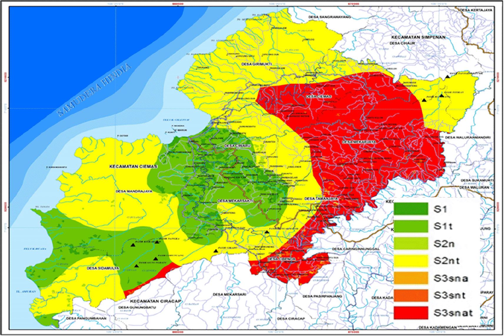
Analysis of the suitability of wetland rice fields will result in the delineation of any area that has the potential to be used as paddy fields. Based on the results of overlaying the suitability of paddy fields in the Ciemas District, it produces 20 polygons that have their own characteristics. Furthermore, the 20 polygons can be further classified into actual and potential land suitability. The actual and potential land suitability maps can be seen in Figures 4 and 5.

Priority map of wetland rice is produced by overlaying irrigated paddy field map, land potential index analysis map, and suitability analysis map. The criteria for priority rice fields to be protected are rice fields that have been irrigated and rainfed rice fields that have a land suitability class of S1. In comparison, those that are not a priority to protect are rainfed lowland rice fields with medium, low, and deficient potential land types and land suitability other than S1. The results of the overlay of the three maps produce 40 land types that have different characteristics (Table 7).
| No | Classification | Area (Ha) | Percentage (%) |
|---|---|---|---|
| 1 | Protected priority | 3,559.72 | 84 |
| 2 | Nonprotected priority | 665.74 | 16 |
| Total (Ha) | 4,225.46 | 100 | |
As seen in Table 7 priority paddy fields to be protected are spread over 3,559.72 ha, or 84% of the total paddy field area. In comparison, paddy fields that are not a priority to be protected are spread with 665.74 ha or 16% of the total wetland area.
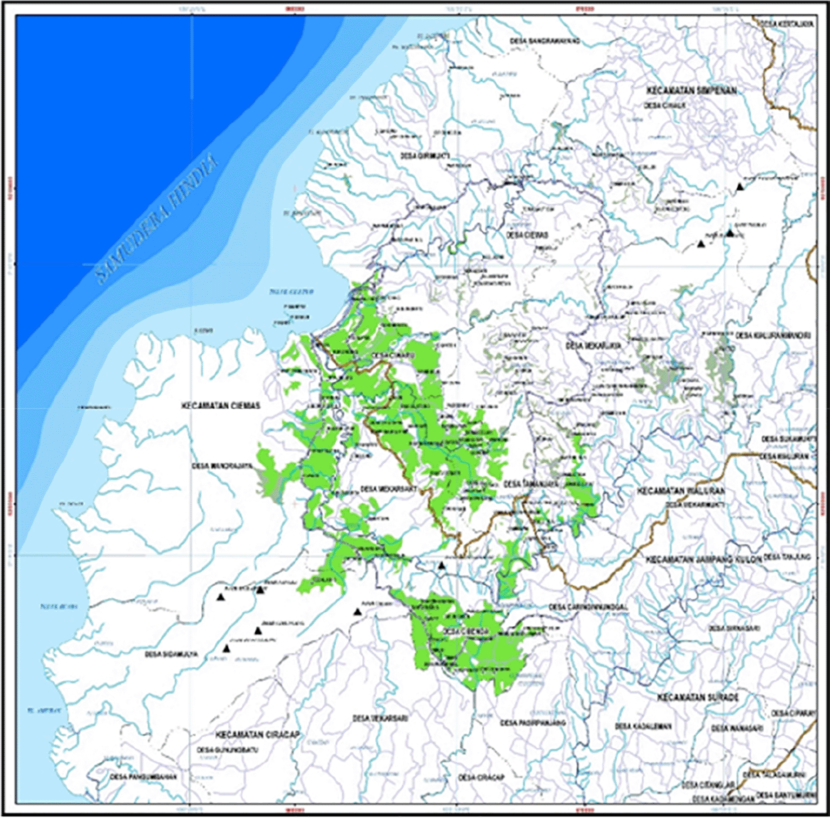
Judging from its distribution, many priority paddy fields that should be protected are scattered in the middle of the sub-district along the Ciletuh, Cikanteh, and Cimarinjung River stream precisely in Ciwaru, Mekarsakti, Tamanjaya, Cibenda, Sidamulya, and Mandrajaya Villages. In comparison, rice paddy fields that are not a priority to be protected are widely spread in the north, namely in the villages of Girimukti, Ciemas, Mekarjaya, and Tamanjaya. More details about the form and distribution of delineation of priority and non-priority paddy fields have been shown in Figure 6.
In Indonesia, rice is the main staple food. To meet the demand for rice, the Indonesian government has established a policy to make rice fields sustainable. Food sustainability is becoming essential so that one of the SDGs regarding zero hunger could be achieved. However, making the rice supply sustainable is not easy. Sometimes food needs can result in reduced forest land or competition with other development needs, which can cause land use conflicts.19 It is challenging to keep paddy fields in Ciletuh Geopark, as it is recognized globally as Geotourism.
The development of Ciletuh Geopark in Ciemas District as a tourism area will change land use/land cover in this region. Lakshmi SR et al6 and Lanya I et al.7 stated that many regions with tourism development have the same experience with function changes on their land. Zhu H et al.20 stated that other tourist destination experiences facing conflict to gain sustainable development in heritage tourist site. On the other hand, this research calculates the limited rice paddy areas that are needed so that there are other areas that still meet tourism development. Therefore, Ciemas, which is defined as an area that has a sustainable supply of agricultural food for the provision of rice for the community, can still develop as a tourist destination without turning rice fields into a tourist area.
This research employed a quantitative method with a supply-demand and suitability analysis approach. These two approaches are the way to give a solution for the competing interest. The paddy field area will be the land-use supporting the Ciletuh Geopark Tourism and food security of the Ciemas community. The availability of paddy fields in this region is still surplus. However, control efforts must be made so that the paddy field area would not decrease.
The analysis showed two priority classifications of paddy fields to be protected and not protected. Following the discussion, it can be concluded that:
1. The policy of land-use change from agricultural to other purposes must begin with calculating the food consumption needs of the community so that their needs are guaranteed.
2. Efforts to control the functioning of agricultural land use for tourism activities must be carried out from the outset. There needs to be strong participation and commitment between the community, government, and private sector to implement and control agricultural and tourism activities to develop well and work together.
3. Zoning regulation must be implemented through policies accompanied by control tools in clear incentives, disincentives, and sanctions.
Based on the conclusion of the study, several recommendations can be proposed:
1. Applying the concept of agrotourism as part of the Ciletuh Geopark tourist attraction by making paddy fields a medium for farming learning for tourists.
2. Involving local farmers and agriculture and tourism communities such as Gapoktan and Paguyuban Alam Pakidulan Sukabumi (PAPSI) in Ciemas District to manage agro-tourism activities.
3. Provision of irrigation networks for paddy fields that have not been irrigated.
4. Improve the limiting factor for potential paddy fields.
5. The regional government to immediately draws up regulations on land conversion concerning the direction of future food security programs. The zoning of productive land that must be maintained is based on binding regulations and sanctions if violated.
6. Incentive and disincentive policies. The policy of providing incentives is given to residents who maintain their productive land through reduced land and building tax payments, ease of obtaining capital assistance, assistance for agricultural production facilities, counseling assistance, post-harvest management, marketing assistance, all of which are carried out by maintaining the stability of agricultural commodity prices. Disincentive policy is given if the citizens do the land conversion that conflicts with their designation or it is against the regulations that apply, e.g., Regional Spatial Plan. However, the residents are free to sell their land.
7. Licensing tourism development must be based on the results of environmental impact analysis through various appropriate analytical tools.
Physical maps are private data that cannot be published by the Regional Development Planning, Research, and Development Agency of the Sukabumi Regency. Researchers have permission from the institution to use the data for this research. However, information from the map can be seen in the Regional Spatial Planning of Sukabumi Regency document and it can be accessed at https://jdihn.go.id/files/308/5822.-rtrw-kabupaten-sukabumi.pdf. Data from the Central Bureau of Statistics of Sukabumi Regency can be accessed at Badan Pusat Statistik Kabupaten Sukabumi (bps.go.id).
Lely Syiddatul Akliyah
Roles: conceptualization, data curation, methodology, formal analysis, Writing – Original Draft Preparation
Hilwati Hindersah
Roles: methodology, formal analysis, Writing – Original Draft Preparation
M. Hanif Fikri
Roles: data curation, visualization, software, Writing – review, and editing
| Views | Downloads | |
|---|---|---|
| F1000Research | - | - |
|
PubMed Central
Data from PMC are received and updated monthly.
|
- | - |
Provide sufficient details of any financial or non-financial competing interests to enable users to assess whether your comments might lead a reasonable person to question your impartiality. Consider the following examples, but note that this is not an exhaustive list:
Sign up for content alerts and receive a weekly or monthly email with all newly published articles
Already registered? Sign in
The email address should be the one you originally registered with F1000.
You registered with F1000 via Google, so we cannot reset your password.
To sign in, please click here.
If you still need help with your Google account password, please click here.
You registered with F1000 via Facebook, so we cannot reset your password.
To sign in, please click here.
If you still need help with your Facebook account password, please click here.
If your email address is registered with us, we will email you instructions to reset your password.
If you think you should have received this email but it has not arrived, please check your spam filters and/or contact for further assistance.
Comments on this article Comments (0)