Keywords
urban expansion, geographic information systems, spatial analysis, Tisaleo.
urban expansion, geographic information systems, spatial analysis, Tisaleo.
The present proposal was developed based on the results obtained from the surveys carried out on the independent variable “Spatial Analysis” and the dependent variable “Expansion of the urban area”; on the properties of the canton of Tisaleo; the same data that allowed us to know the ordered urban growth, this allows us to carry out spatial analysis studies integrating geographic information systems to identify the urban expansion which integrates the territorial components: biophysical, socio-cultural, economic, human settlements, mobility, energy, connectivity and political institutions. Software belonging to the Geographic Information Systems (GIS) are tools that have been generated since the 1970s that improve the collection, processing, analysis and management of geographically referenced data, linking their alphanumeric (quantitative data) and geographic attributes. In GIS, data are generally distributed in layers that represent each characteristic, type of data or event that takes place in a specific geographic space.
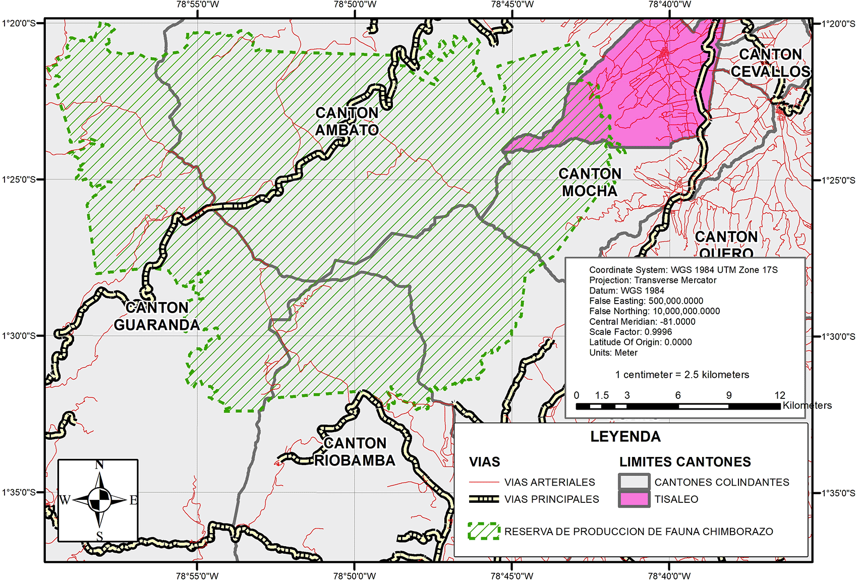
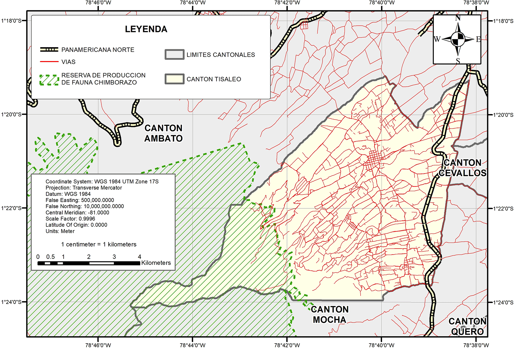
Tisaleo is one of the nine cantons of the province of Tungurahua, located in the southwest of the province. It has an area of 59.64 square kilometres, which represents 1.75% of the province’s territory. It is bordered to the north and west by Ambato, to the south by the canton of Mocha and to the east by the canton of Ceballos. The canton Tisaleo is divided into two parishes: Tisaleo, an urban parish “cabecera cantonal” in the north; and, “Quinchicoto”, a rural parish located in the southeast of the canton. The limits of the canton of Tisaleo have not increased in 10 years. The analysis developed in this research allows us to understand Tisaleo as a decentralised and expansive model that uses more territory to achieve a moderate demographic growth; therefore, the following proposal proposes a spatial analysis through GIS software that delimits the areas of urban expansion of the canton of Tisaleo. It is proposed to carry out an urban growth model with a practical and reasonable standard, thus addressing the use of geographic information systems, maintaining the vision of cantonal development that focuses on: “agricultural, livestock and industrial development, balanced and sustainable growth, intercultural, participatory, inclusive and empowered societies that provide essential quality services and allow the inhabitants to live well”.
Spatial analysis, emerging since the 1950s and 1970s, addresses the need to examine temporal and spatial data, overcoming limitations in data sourcing and representation (Goodchild, 2005). This field, also known as cartographic modelling, involves interactive operations and commands that use maps for spatial decisions, focusing on processes. It reveals geographical structures and analyses formative processes, using concepts such as distance and spatial interaction (Pumain, 2004). Geographic space, according to Pulgarín (2007), is the living framework of an organism, while Castañeda (1997) defines it as the interaction between nature and society, differentiating into urban and rural contexts.
Spatial measurement scales are a long-standing problem in spatial analysis; more details are available in the modifiable area unit (MAUP) topic. Landscape ecologists have developed a number of scale-invariant metrics for ecological aspects of fractal properties. More generally, scale-independent approaches to spatial statistical analysis are not widely accepted.
Spatial sampling allows the identification of a limited number of localities in geographic space to faithfully measure phenomena affected by dependencies and heterogeneity. Dependencies show that, given a location, the value of different locations can be predicted, which does not require observations at both locations. Heterogeneity suggests that the relationship may vary spatially, making it impossible to rely on any degree of dependence outside what may be a small area. Basic spatial sampling schemes include the following modes: random, cluster, and system.
Depending on a given spatial hierarchy (e.g., urban area, city, neighborhood), these basic schemes can be applied at multiple levels. Secondary data, such as the use of property values as a guide in spatial sampling schemes, can also be leveraged to measure educational attainment and income. Spatial models, such as autocorrelation statistics, regression, and interpolation, can also determine sample designs.
The perspectives of the definition of GIS, depends on its functionality, for the purposes of this study, we take the ability of these systems to create digital models of reality with the use of tools as discipline provides for these purposes.
According to the National Center for Geographic Information and Analysis (NCGIA) of USA, 1990, taken by Del Bosque et al. in 2012, GIS is a System composed of hardware, software and procedures for the capture, management, manipulation, analysis, modeling and representation of georeferenced data, with the objective of solving complex planning and management problems (Del Bosque González, Fernández Freire, Martín-Forero & Pérez, 2012).
GIS can be confused depending on essentially different issues, since the same acronym is used for discipline, project or software. The term GIS software corresponds to the program or set of programs that make it possible to develop the discipline and implement GIS projects, thus we speak of proprietary GIS Software, Free GIS of one or another commercial house (Del Bosque González, Fernández Freire, Martín-Forero & Pérez, 2012).
The canton of Tisaleo, according to its current Development and Land Use Plan, referred to the period 2019-2023, is a settlement that dates back more than 4 centuries with the name of San Miguel de Tisaleo, characterized until today by its fertile soil and agricultural vocation, in 1858 it was recognized as a civil parish and was elevated to canton on November 17, 1987. Tisaleo is located on the slopes of the Carihuairazo volcano, and at its eastern end is dissected by the crossing of the Pan-American Highway and the Camino Real, recognized as the old Inca Trail. It has an area of 59.64 km2. Its boundaries are: to the north with the canton of Ambato, to the south with the canton of Mocha, to the east with the cantons of Ambato, Cevallos and Quero and to the west with the canton of Ambato (Figure 1).
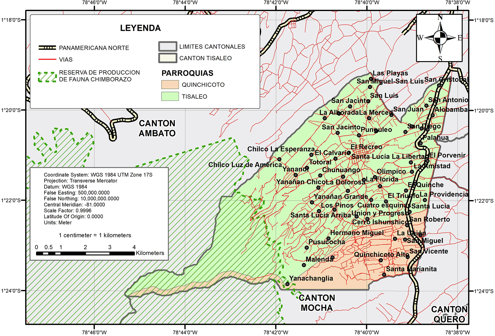
Tisaleo as a canton is divided into 2 parishes: Tisaleo and Quinchicoto; which in turn contains 15 hamlets: Alobamba, Chilco la Esperanza, El Calvario, La Unión, Quinchicoto Alto, San Diego, San Francisco, San Juan, San Luis, San Vicente, Santa Lucía Arriba, Santa Lucia Centro, Santa Lucia la Libertad, Santa Marianita and a large area designated as the Chimborazo Fauna Production Reserve (Figure 2).
According to Article 241 of the Constitution of the Republic of Ecuador (2008), decentralized autonomous governments are obliged to plan their land use and management, while Articles 41 and 48 of the Organic Code of Planning and Public Finance explain that development and land use plans are instruments for strategic development decisions in the territory and their development and land use plans must be updated at the beginning of each administration.
Another tool that regulates territorial planning in Ecuador is the Land Use and Management Plan, according to Article 27 of the Ley Orgánica de Uso y Gestión del Suelo (2016): “In addition to the Organic Code of Planning and Public Finance, municipal and metropolitan decentralized autonomous governments will have a land use and management plan, which will incorporate structural and urban components”.
Thus, the municipal and metropolitan Decentralized Autonomous Governments have provisions and guidelines on the control and use of both urban and rural territory; in this way the Municipal Decentralized Autonomous Government of Tisaleo in 2019 and 2020 carried out the administrative processes for the update of its Development and Land Management Plan and its Land Use and Management Plan.
In this sense, the Autonomous Decentralized Municipal Government of Tisaleo has defined its land in 2 main categories in compliance with the current legal and technical regulations issued by the Superintendence of Land Use and Land Management, as shown in Figure 3.
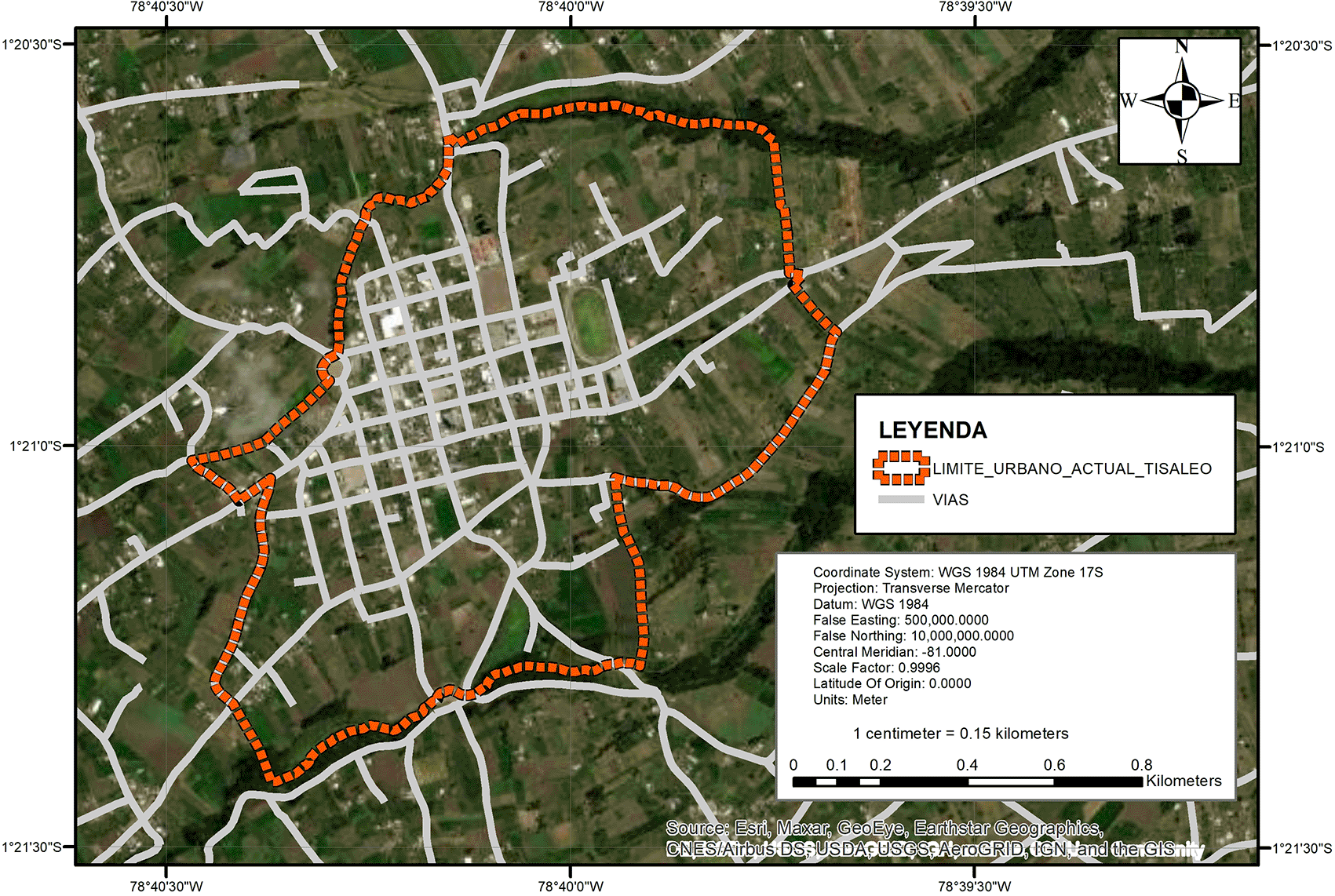
The urban boundary defined in the Development and Land Management Plan for the period 2014-2019 and in the Land Use and Management Plan for the period 2020-2032, contains an area of 132.32 Hectares, which represents 2.22% of the total cantonal area. A priori in map 3 above, one can observe the presence of agricultural land that is still within the urban area defined since 2014.
However, according to the studies that preceded this research, not all the urban area has all the services of the public system such as water, sewage or electricity, it is still worth noting that the percentage of occupation barely reaches the average of 20.74% covering the category of occupation in “formation” (Figure 4).
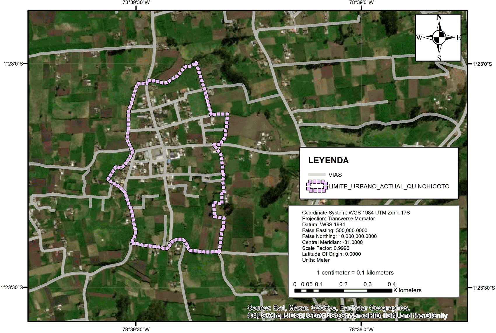
Similarly, the urban area of the parish of Quinchicoto was defined in the Development and Land Use and Management Plan for the period 2014-2019 and in the Land Use and Management Plan for the period 2020-2032, and covers an area of 25.95 hectares, which represents 0.44% of the total area of the canton. According to the Land Use and Management Plan for the period 2020-2032, the current occupation of Quinchicoto is 12.97%, i.e. the urban settlement is still in its infancy (GAD Municipal de Tisaleo, 2020).
According to the Land Use and Management Plan in force for the canton of Tisaleo, two specific areas are defined as urban; Tisaleo as a city and the head of the parish Quinchicoto, which, according to the analysis of the Plan, the two do not exceed 25% of occupation, that is to say that they are still in formation.
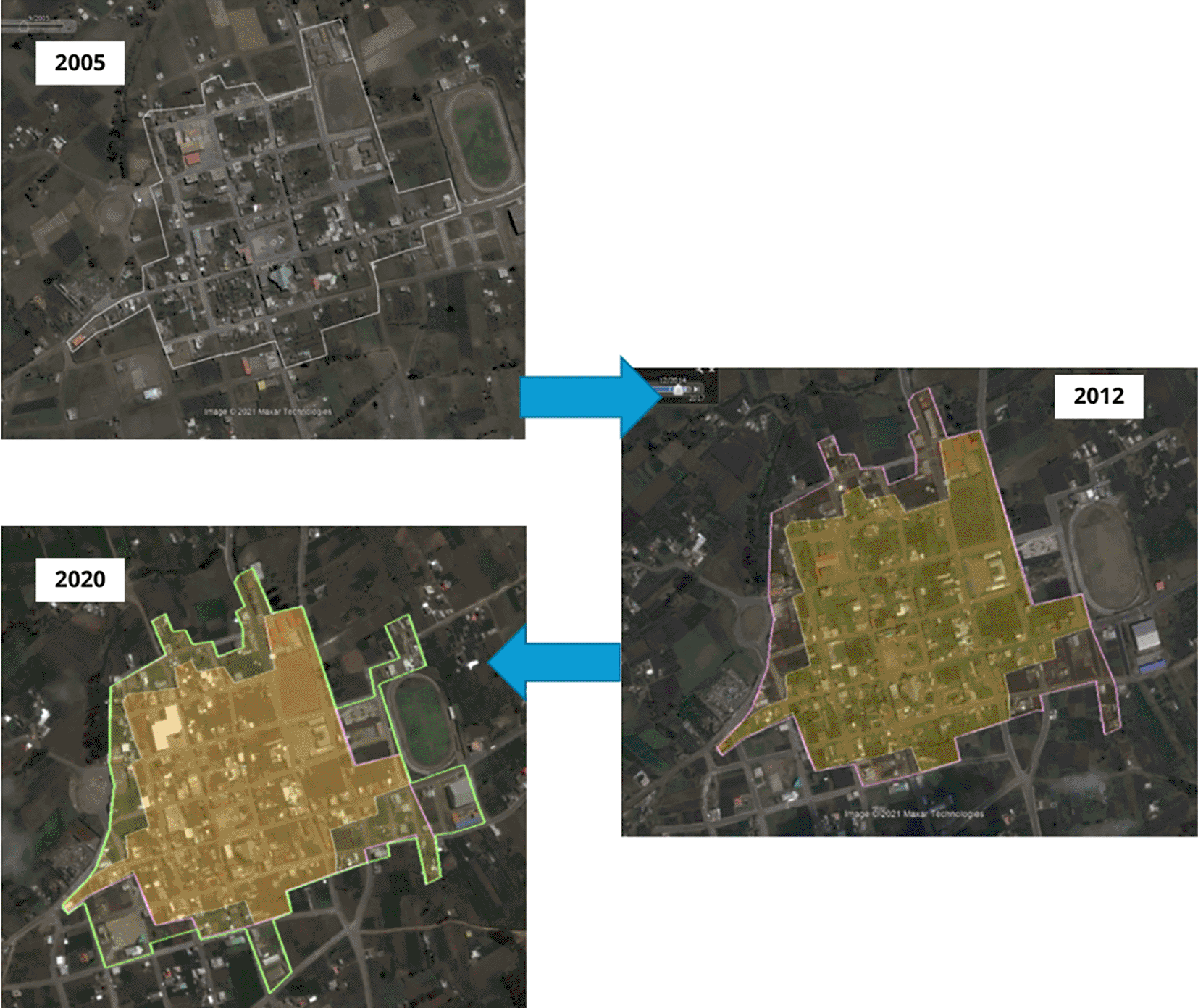
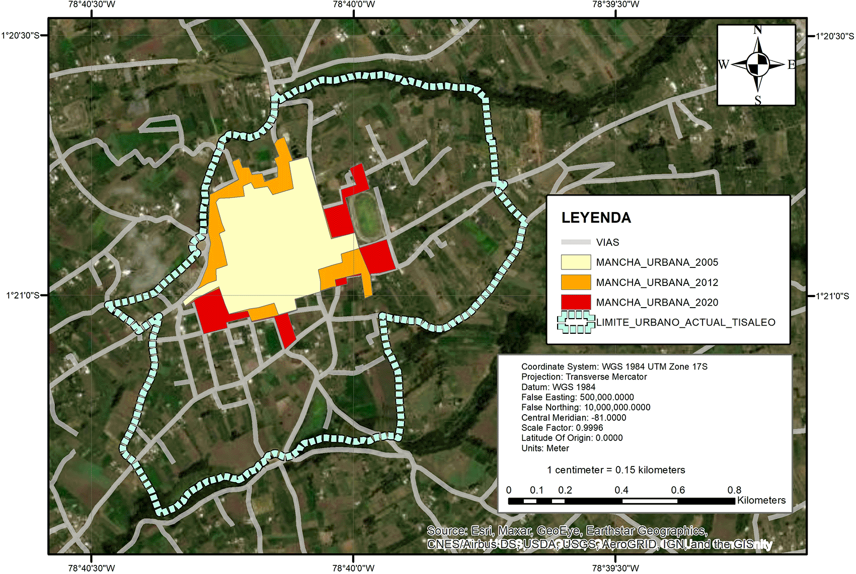
For the same reason, the question arises as to how this urban growth has been developing. For the purposes of this research, we used current and existing tools such as satellite images of the years 2005, 2012 and 2020 (Figure 5, Google Earth, 2024).
If we analyze the percentage of growth based on the current urban limit, we obtain the following results: Table 1
The current urban boundary in relation to the urban area digitized in 2020, is oversized by 487% more than what reality indicates (Table 1), defined in relation to the concentration of housing that has been established since the base year which is 2005, this analysis is made in relation to the ordinance that defines the urban boundary does not match reality (Figure 6).
In the case of Quinchicoto, something similar happens, but due to the resolution of the satellite images and cloud coverage, it is not possible to homologate the process, in this sense, within the PUGS in force in the Gad Municipal de Tisaleo (2021).
The methodology of this scientific research is based on a quantitative approach, using surveys to collect data to be analyzed statistically (Álvarez, 2021). Documents such as the Development and Land Use Plan of the canton of Tisaleo, the Land Use and Management Plan, files and reports of the canton were analysed. The relationship between the independent variable “spatial analysis” and the dependent variable “expansion of the urban area” was analysed.
Field research was carried out in the territory where the georeferencing of urban facilities and services was carried out, as well as a survey of the use given to the property. For the calculation of the present sample, a finite sample size of 1030 properties registered in the urban cadastre of the GAD Municipal del cantón Tisaleo was used, in order to obtain updated information with the reality of the inhabitants of the canton of Tisaleo.
This method is appropriate when the problem to be studied presents data that can be represented by mathematical models, allowing the elements of the research to be clear, defined and limited.
The study design is non-experimental and cross-sectional, since it is based on categories, concepts, variables, events or contexts without the direct intervention of the researcher, and observations and records are made at a single point in time. The research includes documentary, descriptive, explanatory and field components. The documentary research focuses on the search and analysis of secondary data, while the descriptive research is dedicated to present an actual interpretation of the results obtained, describing in detail the spatial analysis with GIS for urban sprawl (Baxendale & Buzai, 2011; Bernal, 2018; Bonham-Carter, 1994). The explanatory research seeks to understand the relationships between variables, and the field research was conducted in situ, collecting information individually in the canton of Tisaleo, focusing on the georeferencing of urban facilities and services. A finite sample size was used for a population of 1030 properties registered in the urban cadastre of the GAD Municipal del cantón Tisaleo (2020).
The Tisaleo canton, being located in the Ecuadorian highlands, contemplates the presence of topography and relief different from that of the Ecuadorian coast or Amazon, which is a component that can condition the location of human settlements, agricultural activities and, in itself, the territorial development of the towns.
In Figure 7 and Table 2, the predominant slopes are those classified between 12 and 25%, followed by those classified between 5 and 12%, which according to the definition of the CLIRSEN and MAGAP object catalogs in 2008 would determine that the relief of slopes in Tisaleo canton are slightly and moderately undulating reliefs, and by the classification of between 25-40% are strongly dissected reliefs (CLIRSEN, 2011).
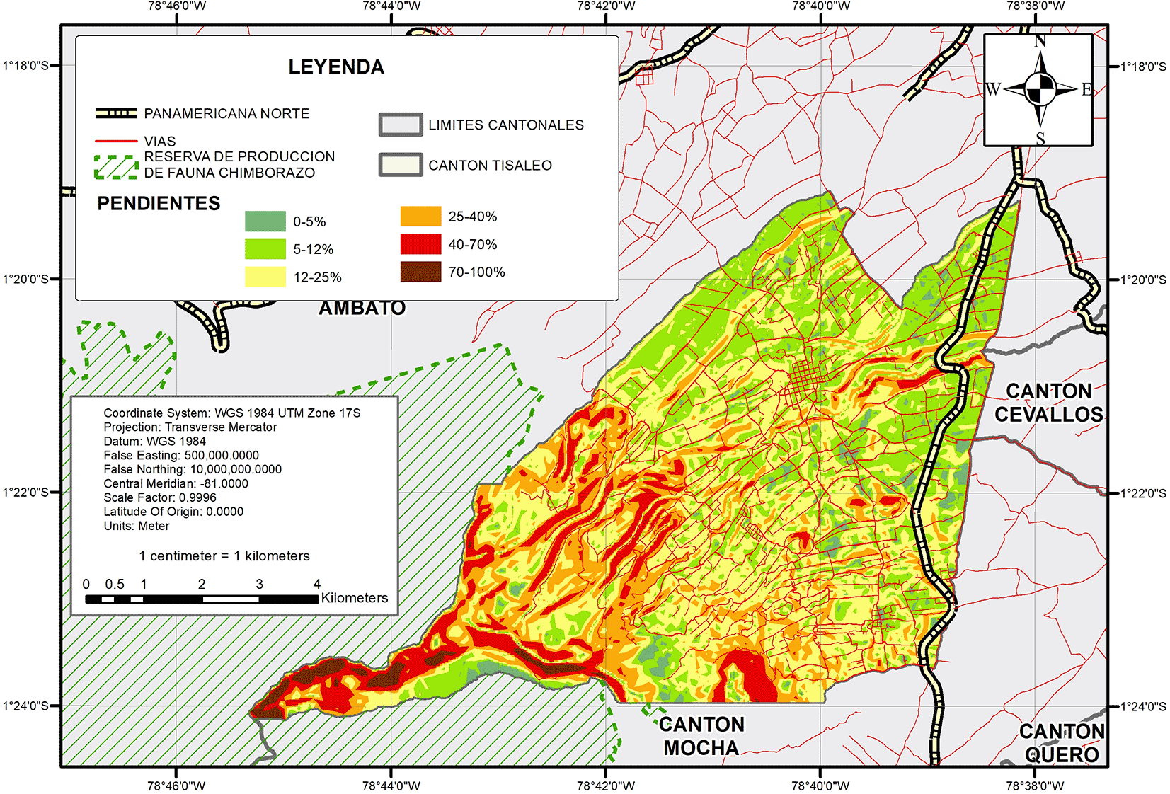
| Slope range | Percentage |
|---|---|
| 0-5% | 3.62% |
| 5-12% | 29.93% |
| 12-25% | 38.87% |
| 25-40% | 17.61% |
| 40-70% | 8.68% |
| 70-100% | 1.29% |
| Total | 100.00% |
An important structuring component to determine population and urban growth is water, in this case the canton of Tisaleo is located on the slopes of Carihuairazo, and has the presence of many streams, springs, streams, and lagoons; the same that dissert the relief and reduce the continuity of the villages in an extensive or regular way. All of these bodies of water flow into two main watersheds: the Ambato and Panchanlica rivers, which contribute to a larger water system, the Pastaza River (GAD Municipal de Tisaleo, 2020).
Another important component that can define or condition urban delimitation and growth are the natural protected areas, which are areas of land especially dedicated to the protection and maintenance of biological diversity, recognized by the State and managed through legal or other effective means (UICN, 1998). In the case of Tisaleo, 18.61% belongs to the Chimborazo Fauna Production Reserve, as shown in Figure 8. The decentralized autonomous municipal and metropolitan governments are responsible for defining and managing land use through their development and land use plans, as well as their land use and management plans: Forest Reserve Zones in water zones and the San Antonio water recharge zone.
The three types of reserves currently have human intervention, to the point that there are private properties within the Chimborazo Fauna Production Reserve, due to the transposition of adjudications and reserve declarations; and in addition to this, the georeferencing technologies of the Natural Areas cadastre and property cadastres are recent.
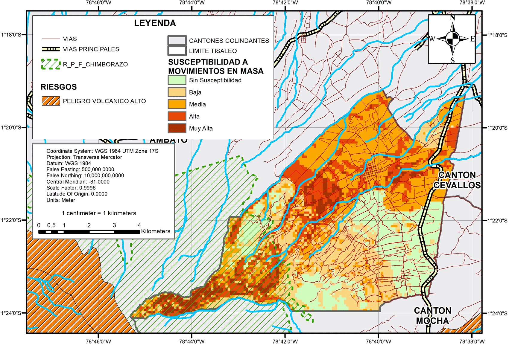
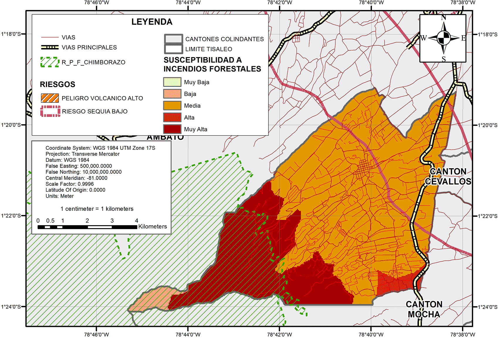
In the biophysical characterization component, one of the most important factors that determines urban growth and its delimitation with areas susceptible to natural hazards. According to the Secretariat of Risk Management, Tisaleo is located in areas susceptible to volcanic hazards, mass movements, drought and forest fires (Secretaría de Gestión de Riesgos, 2022).
One of the main risks is mass movements, as can be seen in Figure 9, which continues, susceptibility is concentrated in the foothills of the Carihuairazo and bodies of water, intersecting with infrastructure such as roads, towns, urban facilities, thus generating in the case of a natural event affecting infrastructure and equipment.
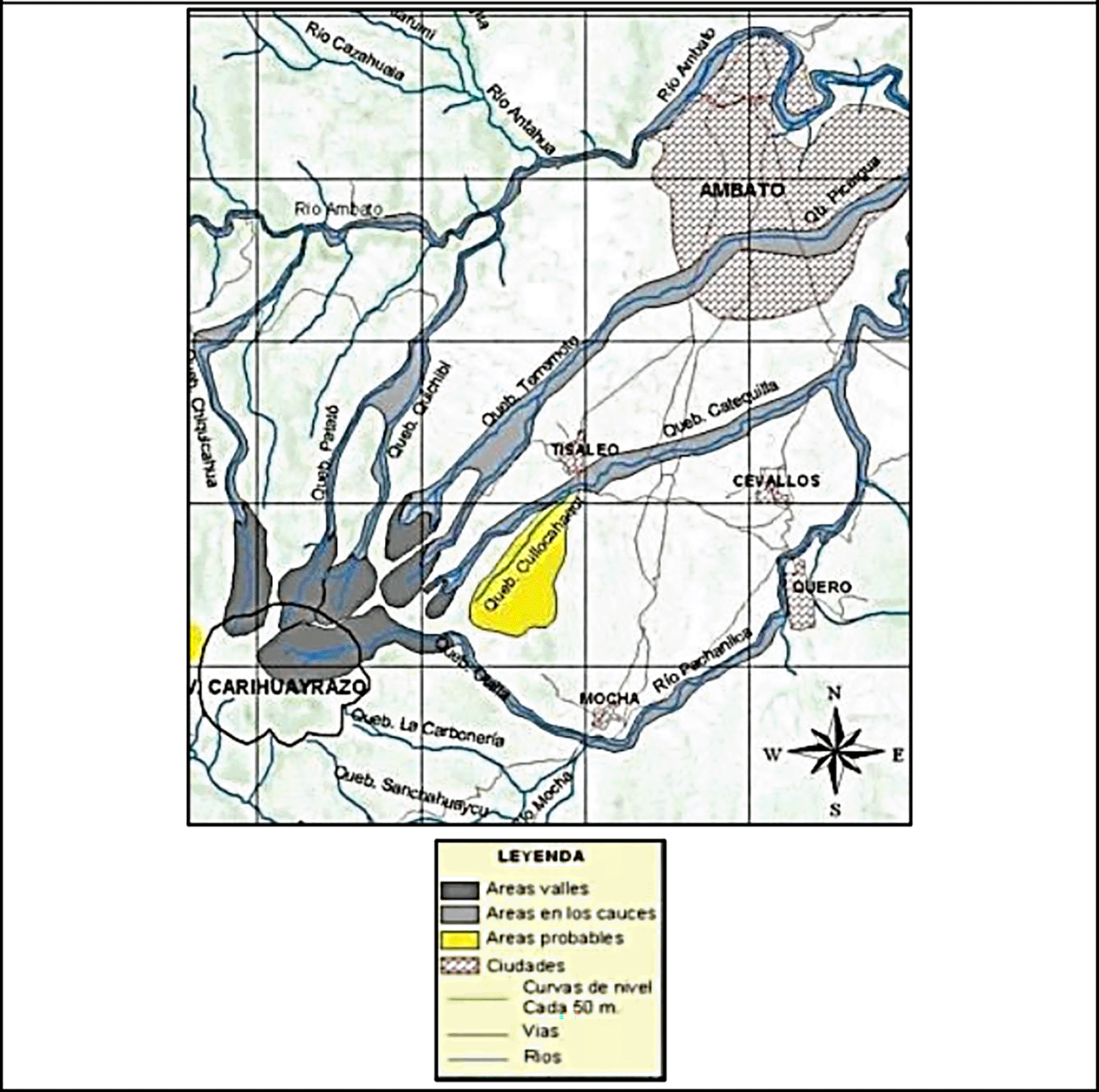
According to the history of the canton, in 1698 there was a collapse of the Carihuairazo volcano, where landslides and mud deposits were recorded as a result of a strong tectonic earthquake. According to Vásconez (2009), these are still present today throughout the canton of Tisaleo, Quero and Ambato (Vásconez, 2009). As shown in Figure 10, taken from the work “Devastating mudflows triggered in the Carihuairazo volcano by the earthquake of June 20, 1698”.
In addition to these risks, the canton of Tisaleo has a low susceptibility to drought and a high susceptibility to forest fires in the paramo areas near the foothills of the Carihuairazo volcano (Figure 11).
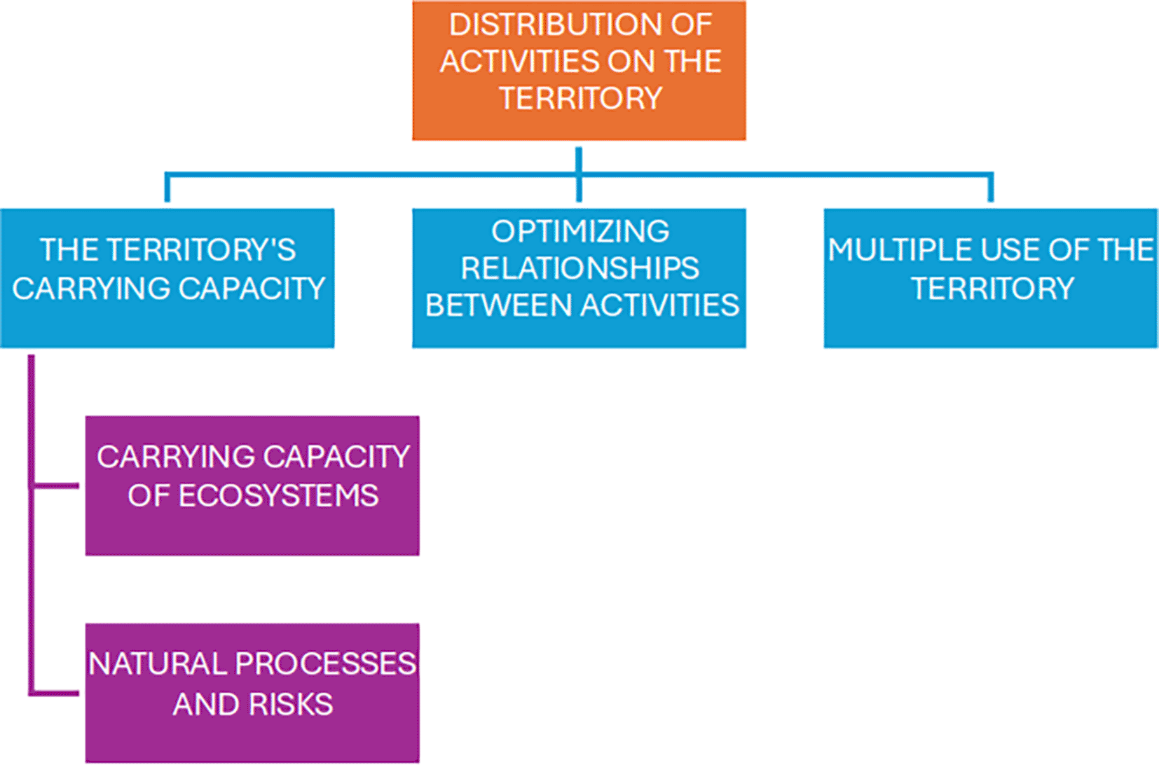
In this sense, the biophysical structure of a territory is the important basis for determining its territorial growth; as indicated by Gómez Orea & Gómez Villarino (2013), both the carrying capacity of the ecosystems and the natural risks are causal for determining the carrying capacity of a space to carry out activities, be they conservation, production, urbanization, among others.
Gómez de Antonio (2003) mentions that endogenous resources, both natural and human, in addition to exogenous activities affect the distribution of territorial activities, but with an urban planning approach, it is the response to the construction of the city, its urban expansion and the classification and urban qualification of the land (Figure 12).
The Organic Law of Land Management, Land Use and Management in its fourth article issues the definition on a populated settlement and other territorial organizations; in this sense if the city and a populated settlement are related, this differs in that a city contains the necessary and ordered goods and services to generate the economic, political, social and cultural development of its citizens, and a settlement itself is a conglomerate of settlers who settle in a concentrated or dispersed way on a space or territory (LOOTUGS, 2018).
The organization of the populated settlements in the canton of Tisaleo, the subject of this study, are not differentiated, that is, according to the Development and Land Management Plan and the Land Use and Management Plan, there are currently 69 population centers, which according to data collected for this research are known as: “hamlets, sectors, communes or other names” (GAD Municipal de Tisaleo, 2020). With this background, it is concluded that the differentiation, delimitation or conceptualization of what can be considered as a city (urban) or populated settlement (urban or rural) cannot be defined by a law or manual, but rather with the individualized treatment of each territory of each canton, due to the exclusivity of the municipalities in defining the classification between urban and rural.
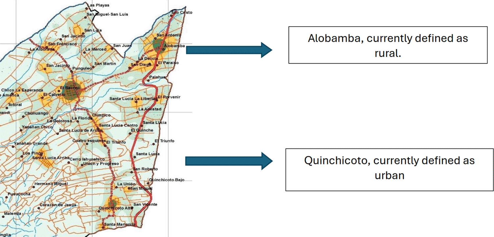
Erroneously, as reviewed in previous sections, the urban limits of Tisaleo and its rural parish of Quinchicoto are oversized, including agricultural and livestock areas without any housing use, and other sectors such as Alobamba, are still defined as rural, having a greater use and concentration of housing, goods, services and equipment than the parish of Quinchicoto (Figure 13).
The delimitation between urban and rural, under current regulations to generate a Land Use and Management Plan, are mainly the following variables: road network and transportation, water for human consumption, sewage, electric service, parks and squares, health facilities, education, social welfare, recreation and sports, security, and public administration. In this sense, for the purposes of this research, each of these factors was analyzed separately, as these are the ones that would delimit the urban expansion zones in the short, medium and long term.
Regarding the road and transportation network, it converges in the characterization of the cantonal road network that can be differentiated by some indicators such as: annual average daily traffic, roughness, roadway, condition, width, works of art, among others; however, for the purposes of this study, the hierarchy, coverage of the road network, transportation routes and their equipment are analyzed; these characteristics are a vital part as a component of the urban development of a town, canton or country. The cantonal road network has a total length of 302.53 km and is composed of five types of roads: cobblestone, asphalt, concrete, stone and dirt. Dirt roads predominate with 165.78 km, representing 54.80%, followed by asphalt roads with a length of 91.01 km, representing 30.08%, and only 2% are cobblestone roads. Figure 15 shows where asphalt and cobblestone roads are concentrated, areas that are new for building new housing or plans (GAD Municipal de Tisaleo, 2020). Traffic and transportation management in the province of Tungurahua for the cantons of Baños, Cevallos, Mocha, Patate, Pelileo, Pillaro, Quero and Tisaleo, generate their own traffic and transportation plan, where they define a hierarchy of their roads as follows (Figures 14 & 15):
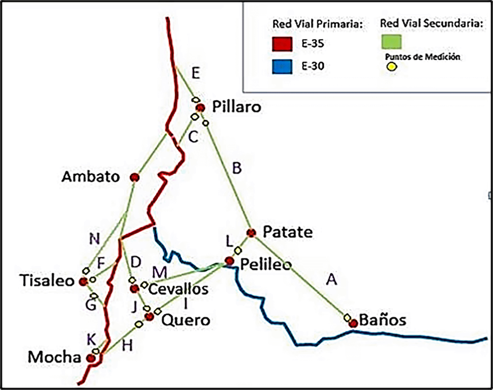
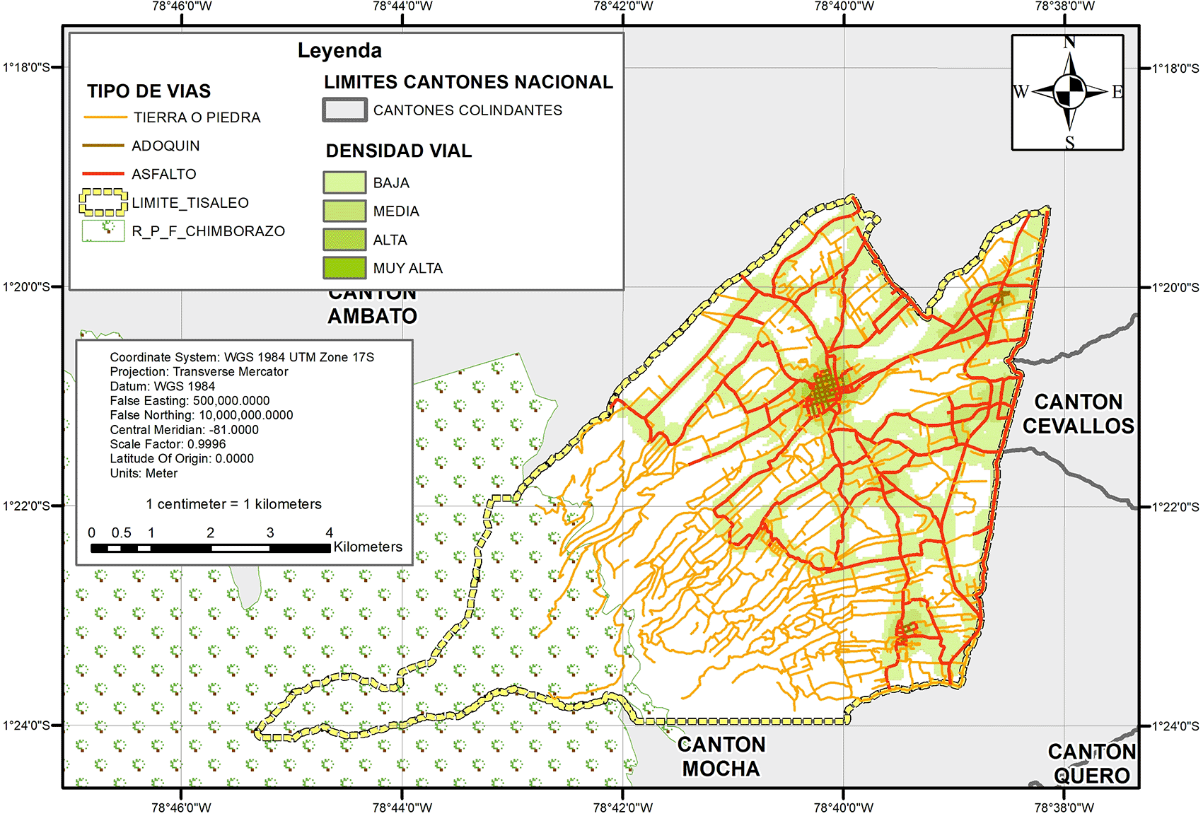
Tisaleo is connected by the Panamerican Highway E35 and articulated by secondary roads that connect with the cantons of Ambato, Cevallos and Mocha, and a countless number of third order roads that are paved and/or dirt roads. In terms of mobility, the Panamerican Highway and the secondary roads are currently being used as nodal roads, where all the traffic of the third order roads converge and are progressively becoming overcrowded with vehicles due to the increase in the number of vehicles. Regarding public transportation routes, the presence of the Pan-American Highway and secondary roads, this service and the infrastructure of bus stops are concentrated in these 2 types of roads; and mixed cabs complement the transportation coverage at the level of the entire canton (Empresa Pública de Mancomunidad de Tránsito de Tungurahua, 2017).
A basic element that contributes to the growth of cities is the drinking water and sewerage service, in the case of Tisaleo, for these two elements of review, the existing information of the existing multifinalitarian cadastre in the Municipal GAD, having the following results:
At the cantonal level, the concentration of water and sewerage services coincides with the presence of asphalt and paved roads, i.e., when roads are increased, they go hand in hand with water and sewerage services. As can be seen in the following map (Figure 16).
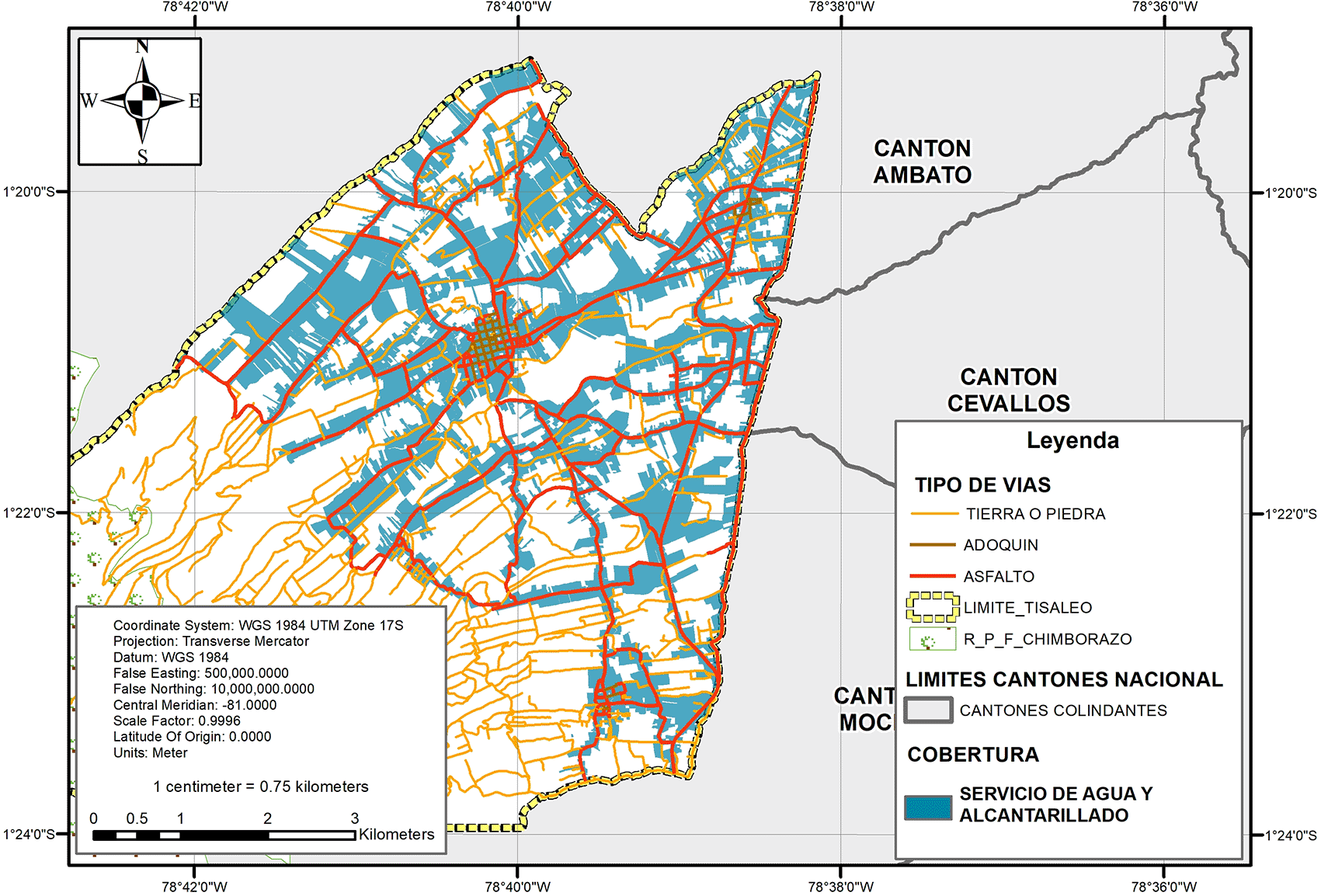
The analysis was carried out with a universe of 16048 properties registered at the Head Office of Appraisals and Cadastre of the Municipal Government of Tisaleo, of which were selected based on the attributes of sewerage and water for human consumption; 52% of them have access to drinking water and 37% have sewerage; therefore, 37% have both water and sewerage.
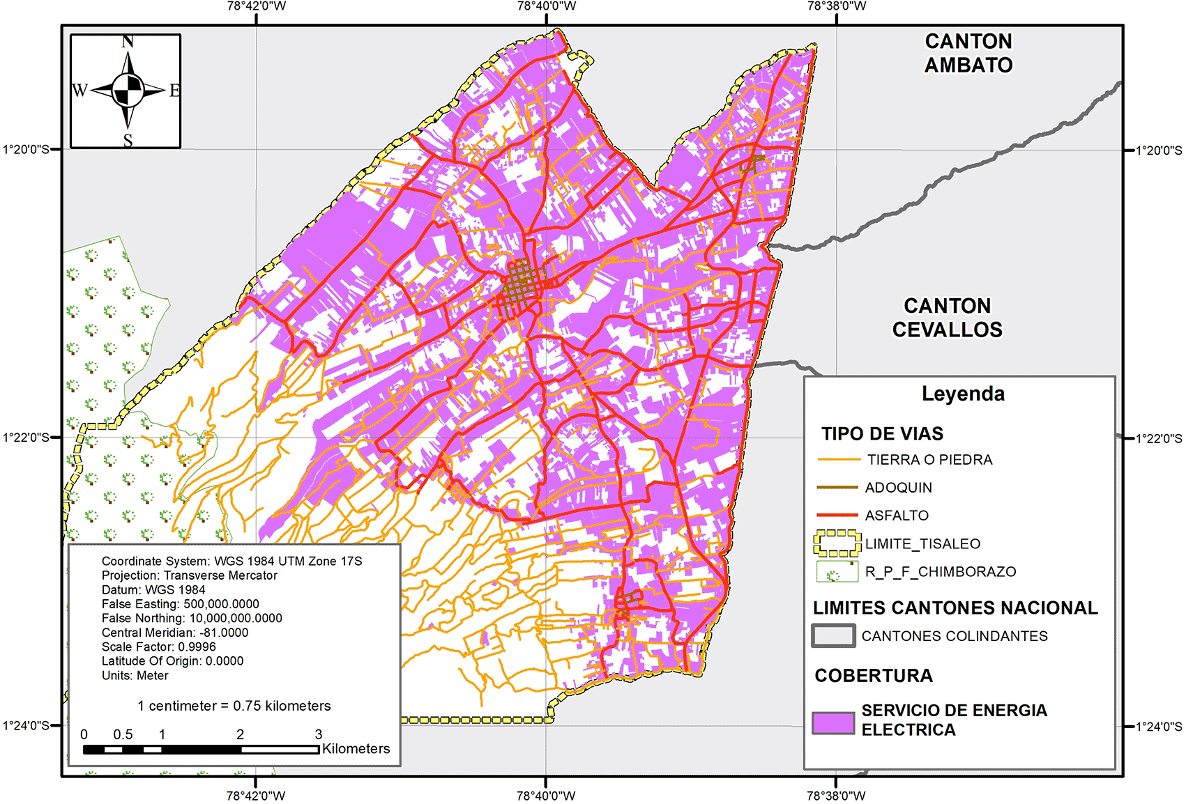
Another important factor in determining the growth of urban areas is the provision of electricity service; since, in addition to water and sewage coverage and accessibility by roads and transportation, these are the basic services to encourage new construction of housing or commerce, in addition to biophysical and socioeconomic factors.
Electric power coverage covers 51.66% of the existing properties in the canton, and there is an electric substation with the same name (Tisaleo) located in the north of the canton, in the Chilco La Esperanza hamlet; this station is part of the 500 kV transmission system and connects the new Coca Codo Sinclair and Sopladora projects (Figure 17).
Therefore, it is the detail of the above elements that can determine the territory’s capacity to provide for the construction of housing or urban facilities in the short, medium or long term, but it is also convenient to analyze the coverage of public or private urban services such as education, health, social welfare, recreation and sports, and security.
To analyze the coverage of social and public services and facilities (Table 3), coverage is measured using radii of influence, with neighborhood, sector, zone, city or regional scope, and for each of the services and facilities there is a corresponding radius described in the following Table 3:
The relationship between public and social service facilities and their coverage depends on the existing demand of the population, i.e., in Ecuador and Latin America the causality for the construction of social service facilities does not depend on medium or long term planning but rather on the needs of the population; i.e., the construction of streets, housing and basic services increases faster than the construction of public and social service facilities.
Socio-economic characterization:
In the last census of 2010 conducted by the Institute of Statistics and Census, it dates a number of 12,137 inhabitants, but for the year 2020 according to the same population growth data (1.80%) indicates a total of 14,317 settlers. Fifty-one percent of the population is female and 49% is male, and a quarter of the population is mostly young.
Tisaleo is an eminently agricultural canton, with agricultural activities distributed from the highest part with pastures for livestock, in the middle part with the production of short-cycle crops and in the lower part with fruit crops, taking advantage of its young economically active population, which represents 26.4% of the total EAP. According to data from its current cantonal development plan, 74.13% of its land has irrigation for its crops; as a result, agriculture and construction are the main sources of income for its inhabitants (GAD Municipal de Tisaleo, 2020).
Land fragmentation is recognized as a cause of decreased production capacity and yields, according to population data within their current plans as of the date of this research; on the other hand, an important problem is that 40% of the arable layer is worn and degraded. In terms of agroindustrial initiatives, there have been few initiatives to improve the added value of their products and to technify the areas that are still purely productive (GAD Municipal de Tisaleo, 2020).
Process of interrelation between structuring elements of urban expansion in the canton of Tisaleo.
Having described the elements that structure and determine urban growth in a generalized way, territories and their endogenous and exogenous characteristics differ greatly within each province, each country and continent; it is impossible to compare one canton with another. In this sense, for this research we define which are the most common structuring elements with easily accessible information, and the relationship that these elements have in order to later analyze these variables and better define urban limits and their expansions.
Knowing the information collected, its sources and scales are of vital importance to categorize it, weight it and evaluate whether or not it is feasible to use it within a spatial analysis with GIS software (Figure 18).
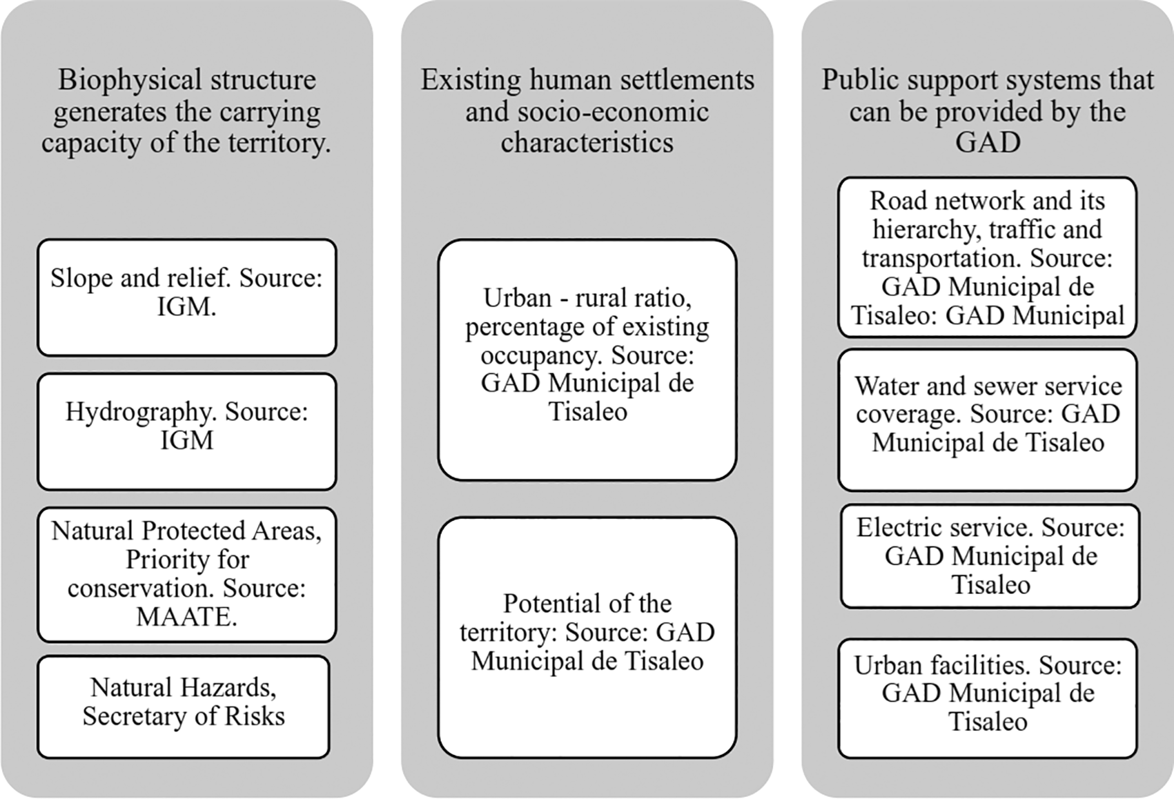
These three major groups contribute to the orderly urban growth of the canton of Tisaleo, but the degree of importance of these are very different, i.e. the causality between these parts from having a suitable biophysical area and out of natural risks in order to implement roads, services and equipment; for this reason these two major groups will be taken quantitatively, which are the biophysical structure and the public support system. In order to prioritize which of these factors has the greatest degree of intervention in urban expansion, a double-entry matrix was used, with the following evaluation criteria (Tables 4 & 5):
Once evaluated the importance between each variable, it coincides that, natural risk zones are considered as the most important factor that would determine urban growth, followed by hydrography and relief, in this way once a spatial analysis is performed will be the most suitable way the weighting of the variables and so that its value is the one that has the most interference in terms of planning an urban boundary and its growth.
Cities are dynamic, the constant demand for housing and the population’s need for a place to live have generated that rural soils, from productive soils to soils with susceptibility to natural risks, are populated. In the case of Tisaleo, according to this research, it has agricultural potential, although its connection with the canton of Ambato, which is the provincial capital, and because of its location on the Pan-American Highway, urban expansion has been occurring in a disorderly manner. Tisaleo, located in the inter-Andean zone of Ecuador, on the slopes of the Carihuairazo volcano, has heterogeneous bio-physical characteristics that determine the distribution of its settlements, as well as a very high coverage of basic services in relation to the average for the country and the province of Tungurahua. According to the surveys conducted, housing occupancy within the investigated properties ranges from 2 to 3 people, thus having an under-occupation of the land that could be concentrated in areas that are suitable for housing and commerce.
Each of these elements has different importance and influence on the territory in terms of the land’s suitability for urban growth, since a biophysical element is more decisive than an infrastructure element such as a road or electric power. The synergy that marks the construction of new roads leads in this case that the new constructions are directed towards where the roads are being opened and improved.
With all the data and their degree of importance, one of the tools used to interact and intersect their variables involves the use of geographic information systems software, which more than interrelating their alphanumeric data, also interrelates geographically georeferenced data, thus adding spatial coincidences in terms of the characteristics of territory that would improve the conditions where new urbanization and construction of housing, stores and equipment can be carried out. In the case of Tisaleo, where the coincidences of aptitudes for urban growth converge, it coincides with the areas currently considered as urban, which are Tisaleo and Quinchicoto, but its limit is oversized, that is, it includes areas that do not have the aptitudes to be urbanized, as well as areas such as Alobamba and Santa Lucia Arriba that are considered as rural, but have all the characteristics to be considered as urban.
| Views | Downloads | |
|---|---|---|
| F1000Research | - | - |
|
PubMed Central
Data from PMC are received and updated monthly.
|
- | - |
Provide sufficient details of any financial or non-financial competing interests to enable users to assess whether your comments might lead a reasonable person to question your impartiality. Consider the following examples, but note that this is not an exhaustive list:
Sign up for content alerts and receive a weekly or monthly email with all newly published articles
Already registered? Sign in
The email address should be the one you originally registered with F1000.
You registered with F1000 via Google, so we cannot reset your password.
To sign in, please click here.
If you still need help with your Google account password, please click here.
You registered with F1000 via Facebook, so we cannot reset your password.
To sign in, please click here.
If you still need help with your Facebook account password, please click here.
If your email address is registered with us, we will email you instructions to reset your password.
If you think you should have received this email but it has not arrived, please check your spam filters and/or contact for further assistance.
Comments on this article Comments (0)