Keywords
Road traffic injuries, burden, good health and well-being, monitoring system, Low- and middle-income countries
This article is included in the Global Public Health gateway.
Road traffic injuries, burden, good health and well-being, monitoring system, Low- and middle-income countries
The World Decade for Road Safety that ended in February 2020 concluded on the absence of a reduction in road mortality and morbidity rates in low- and middle-income countries.1,2 This decade failed to reduce mortality and injuries, but had the merit of placing the issue of road traffic crashes and road traffic injuries at the heart of political agendas, since the decade of action is extended under the Sustainable Development Agenda with target 3.6. The ambition is to reduce by 50% the toll of deaths and injuries on the world’s roads by 2030. More recently, a WHO report3 reported a slight decrease in the number of road fatalities worldwide, but underlined that nine in ten deaths still occur in low- and middle-income countries. The risk of death is three times higher in low-income countries than in high-income countries, while low-income countries own only 1% of motor vehicles worldwide.3
Road crashes are a major public health problem in low- and middle-income countries. They have risen from the 9th to the 7th cause of mortality in a few years4 while they have disappeared from the chart of the top 10 causes of mortality in northern countries, on the same period of time. Though statistics are already alarming, there is a recognition that national records have been under-estimated by official statistics for most LMICs. West African countries are typical LMICs5 on the matter, as they derive their data from police intervention reports. However, police agents are not the most called-upon actors when a crash involving injuries or deaths occurs. In most cases, firefighters are called to intervene, rescuing and transporting victims to health centres.6 Empirical evidence from Burkina Faso and Côte d’Ivoire supports that relying on the data of firefighters and hospital emergency is more accurate.7,8 However, producing reliable routine statistics remains a challenge for many countries. African countries are not able to produce reliable statistics, given the current data capture methods.1,9 Therefore, despite the recognition of the health burden represented by road crashes, to our knowledge there is no epidemiological monitoring.
However, it is essential to estimate the incidence, lethality and types of morbidity to identify and design the most accurate interventions to implement. Specifically, designing targeted interventions to reduce the burden of road crashes relies on a prior accurate assessment of the number of crashes, injuries and deaths. Road crash and injury monitoring systems can provide this crucial information to assess the burden of road injuries, identify groups at increased risk, describe risk and protective factors, plan interventions and monitor the impact of interventions.10
Nevertheless, to date, no country in West Africa has this type of system, which should be at the heart of road safety agencies’ operations in connection with the Ministries of Health’s health information systems. Various attempts to provide data capture tools have emerged, but the lack of adaptation to local contexts has hindered their potential. Indeed, these tools are often imported from the outside and are not devised and designed by national authorities according to specific needs and contexts, and implementation constraints. Although various structural projects concerning transport have been developed, the road safety element has never been applied and has not reduced the number of crashes. The PAMOSET11 project, for example, sought to submit an crash monitoring tool or device in Côte d’Ivoire, developed by the World Bank, which had initially been designed for the Philippines.12 Despite the many discussions with OSER, the tool was never adapted nor deployed for the situation in Côte d’Ivoire. In addition, several scientific experiments, limited in time and at the scale of capitals, have emerged and have demonstrated that, with a concerted approach between the actors, an easy-to-use and sustainable monitoring system could be implemented in these countries.7
Burkina Faso is no exception among these countries. Although it has both a legal framework and a lead organisation13 in the field of road safety, it does not have a system of crash monitoring and therefore a reliable assessment of the burden in the country. Yet Burkina Faso is marked by a significant road crash rate, especially among vulnerable users of two-wheel motor vehicles.
This article is based on the results of action research focusing on the implementation of a system for monitoring road crashes and road injuries carried out between 1st October 2020 and 30th September 2021 in Ouagadougou, Burkina Faso. The aim of this research was to demonstrate the feasibility of a systematic capture method capable of improving estimation of the road crash and their characteristics by not relying exclusively on data from the National Police. Carried out in partnership with the three Centre Hospitalo-Universitaires (CHU – general teaching hospital) of Ouagadougou and the National Police, the monitoring system aimed to assess (1) the burden of road crashes and serious road injuries in Ouagadougou and (2) to identify and characterise the city’s crash prone areas.
The burden of road traffic injuries is defined by the accumulation of the socio-economic and human consequences associated with road crashes.14,15 The definition includes loss of life, injuries, medical costs, property damage and impacts on economic productivity and health systems. Assessing a burden of road traffic injuries in LMICs is therefore complex faced with the lack of data and the poor quality thereof. In this article, we propose to describe the characteristics of the populations affected, to assess loss of life, injuries, estimate their severity and material damage. Our approach is articulated in 3 steps with associated methodologies, (1) the development of a monitoring system that archives and allows the consultation of data, (2) a geolocated prospective data capture with the National Police, and (3) a prospective data capture with the 3 CHUs of Ouagadougou (Yalgado, Bogodogo and Tengandogo).
The prospective study was conducted in Ouagadougou, the capital of Burkina Faso in West Africa. The population of Ouagadougou stood at 2,415,266 in the 2019 census (INSD, 2022). Ouagadougou is organized into 55 sectors that cut the city in two, characterized by a city centre and planned urban outskirts, bordered by unplanned developments (slum areas). The traffic network, where the competent authorities intervene in a road crash, concerns only the formally planned city crossed by a mostly earth roads and 20% of asphalted lanes (estimated in 2015) where most of the movement flows are concentrated. The numerous resurfacing roadworks undertaken since that date suggest that this percentage has improved slightly without, however, constituting fundamental changes in the current road network.
To meet the objectives of this research, the team has developed a monitoring system that allows the prospective acquisition of data from geolocated crash reports from the road traffic crash site by providing police officers with smartphones equipped with an information entry application (Open Data Kit form). A platform also allows real-time mapping of data captured by agents on a dedicated website. A dashboard, with secure access, presents summaries of the data captured and makes it possible to assess the dynamics of crashes in the city in near real time. An export module for GIS software and spatial and statistical analysis is also available. During the same study period, the trauma emergency departments of three CHUs in Ouagadougou captured, on tablet, epidemiological data of patients admitted for road injuries. A forward-looking data capture was carried out over 12 months, from 1st October 2020 to 30th September 2021. Nearly 90 police officers were trained in the use of the capture tool and 10 hospital interns.
Written informed consent was obtained from all participants prior to their inclusion in the study. The consent form was read aloud by physicians, and participants were also given the opportunity to read it themselves. Consent was documented by an electronic signature on a tablet, and all signed forms are securely stored in the study database. No children were enrolled, as pediatric cases are managed in another university hospital.
The data was synchronized in two remote secure servers and accessible from a local station, equipped with a Geographic Information System (GIS).
The variables necessary for the first objective of the study come from the capture carried out by police officers and hospital interns. These include the number of crashes, types of injuries, number of injured, of deceased, types of users, their gender, age of the victims, weather at the time of the crash, lighting, type of road surface, visibility (road obstruction), type of infrastructure, state of the road and the types of vehicles. As regards the variables from the CHUs, we monitored every patient admitted to hospital and recorded: their socio-demographic characteristics (age, gender, occupation, level of education), the location, nature and severity of each of their injuries, the place and time of their crash. As AIS (Abbreviated Injury Scale) or ISS (Injury severity score) are not routinely used by orthopaedic surgeons in Burkina Faso’s university hospitals, we decided to estimate a proxy of it by asking to rate the severity of each lesion on a scale of six modalities ranging from Mild to Maximal severity [1]. We discussed extensively with the doctors who collected the data, to ensure they had a consistent and similar way of rating. During these discussions, it appeared that the distinction between intermediate modalities was not always clear. Therefore, during the data curation we decided to group modalities to obtain two modalities only: “Mild/Moderate” and “Serious to maximal”. From these severity scores for each lesion, we retained the maximal score per patient.
For the second objective, the variables are the geographical coordinates of road crash acquired by GPS integrated into the capture tools. The two objectives share the following common variables: the number of crashes, number of injured, number of deaths, gender, and the type of users, which will make it possible to estimate the burden.
To analyse the burden of road traffic injuries, standard descriptive statistics were used. The data from the National Police present variables of severity (serious and less serious) which do not correspond to a medical diagnosis. To distinguish crashes with only material damage from those involving casualties, we aggregated all injuries, serious or mild, in the injured variable. The missing data were processed by the simple imputation method by Hot-Deck.16 The simple mean imputation method made it possible to correct the missing data of continuous quantitative type with less than 10% missing value. For qualitative variables, whose missing values were ≤5%, the modality imputation method with the highest number of observations was used. Variables with a missing data rate of more than 30% were systematically discarded.
Kernel smoothing is mainly used for the estimation of a relative risk based on specific locations of cases in a geographical area, here road crashes. KDE allows the spread of risk to be extrapolated to areas surrounding a defined group.17 It divides the entire study area into a predetermined number of cells. A circular neighbourhood around each road crash site is generated. The mathematical function of the kernel ( Figure 1) is then applied, it varies from 1 at the site of the road crash to 0 at the boundary of the neighbourhood. A symmetrical and circular surface of the user-defined bandwidth is placed above each crash location. The method evaluates the distance between the point and a reference location based on a selected kernel function. The placement of these kernels at the road crash site creates a smooth and continuous surface. The values of all surfaces are added for this reference location. The procedure is repeated for successive impact points. The kernels estimate the density distribution for each road crash site.
Formula 1: Kernel density estimate.
The fixed bandwidth of 195 metres was defined.18 It is based on an analysis of the distance of the closest neighbours, i.e. the average distance observed between road traffic crashes. This analysis was performed using Qgis 3.26 and the Density Analysis extension.
The developed system operated round the clock with a day of interruption during a fire at the data host, but with no loss of data. Each actor had private access to both raw and descriptive data. The smartphones (n = 16) and tablets (n = 6) distributed to the 8 police stations of the National Police and the 3 CHU Ouagadougou showed only two breakdowns in the entire fleet. Data entry was performed properly on the whole, even though some variables were never completed because agents considered them too time-consuming (driving licence number or insurance policy number).
The total number of observations stands at 3,622 road traffic crashes, the proportion of missing data standing at 2% ( Table 1). During the observation period, a total of 58 deaths was recorded (1.6%), 1,186 injured (32.7%) and 3,159 crashes with material damage (87.2%). Four-wheel motorized vehicles (n = 2 477 or 68.4%) are those most involved in road traffic crash with a 17.2% proportion of crashes with injuries ahead of those involving two-wheel motorized vehicles (n = 1 296 or 35.8%), followed by motorized vehicles in the heavy goods vehicle category (730 or 20.1%). Non-motorized vehicles account for a small proportion of observations (68 or 1.9%). Only 12.9% of the users involved were women. 2,668 (74.5%) crashes occurred during the day compared to 913 (25.5%) crashes at night. Almost all crashes (90.8%) occurred on asphalt roads. The majority of crashes occurred outside intersections (57.1%) compared to 41.7% at the different intersections of the city. Victims’ ages were not entered properly by police officers, who argued that the information took too long and was too complex to complete. The data on the severity of crashes are aggregated because the definition of the severity from the National Police, which distinguishes crashes with minor and serious injuries, is decided without medical evaluation. Here, we prefer the term “injured” which corresponds to the sum of the two variables (mild injuries and serious injuries) of the National Police, the severity will be assessed from the data of patients admitted to the CHU. For those road traffic injuries, they account for 32.7% of the sample, of which 5.4% involve at least one woman. Among these crashes with injured people, it is vulnerable users of two-wheel motorized vehicles that are the most represented (26.4%).
The three units of Urgences Traumatologique de Ouagadougou (Accident & Emergency – A & E) admitted 4,766 road traffic injuries over the same period, of which 85 (1.7%) had already died upon arrival, and 63 (1.3%) died during their stay. Of the living casualties, 86% consented to the survey, constituting an analysis sample of 3,988 admissions. Nearly 63% of those injured were admitted to the emergency room at the Yalgado Hospital, compared to 33% at the Bogodogo Hospital and only 4% in Tengandogo. 2/3 of the injured were men, and over half of them were between the ages of 18 and 24 ( Table 2). Motorcyclists accounted for 89% of casualties, followed by pedestrians (5%) and cyclists (3%). The BNSP (Brigade Nationale des Sapeurs Pompiers – the national fire brigade) was the prevailing mode of arrival (61%), but more than a quarter of those injured came without medical accompaniment, alone or were brought by a third party. Finally, almost three-quarters (72%) of victims were the only ones injured in the crash.
Regarding the state of consciousness of patients upon admission to the emergency room, Glasgow’s score of 95% of road traffic injuries was considered normal. For the majority of injured admitted, the injuries were mild. The most severe injury for more than 60% of casualties was assessed as mild or moderate. The severity of an injury differed greatly from one hospital to another, the hospital of Bogodogo receiving patients with a lower proportion of serious injuries. Severe injuries were also more prevalent in males (38%) that females (27%) ( Table 3).
Regarding the location of an injury, the lower limbs are those mainly affected (49.5%) followed by injuries to the head and face (45.9%) and upper limbs (28.7%). In terms of severity, injuries to the chest are the most serious (57% of the patients injured in the abdomen have a injury classified as severe), followed by those to the head (41%) and to the lower limbs (38%).
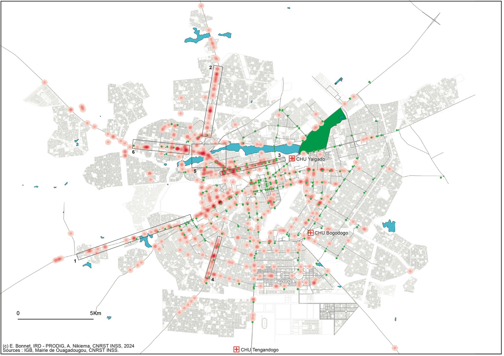
All major roads to the city centre have significant crashes densities ( Figure 1), especially near traffic lights (green point) and major intersections. The city centre, around the United Nations roundabout and the roads serving the central market, the presidency (1) and the shopping district of Koulouba (2), have the highest densities. The Rue de la Liberté (3) and the urban roads joining the national roads leading to Kamboinsin (4) and Bobo-Dioulasso (5) are notable road traffic crash-prone routes. Interchanges were built on these roads at key traffic hubs in order to relieve traffic congestion and reduce its corollary, crashes, which were particularly visible at the northern interchange (6). They have helped to reduce the phenomenon. To the south of the city, the Avenue de la Dignité (7) tarmacked for less than a decade, has high densities of minor crashes. Although most reported crashes take place along paved roads, interventions are also observed in neighborhoods, but concentrations remain low. This also applies to slum areas but more rarely in the light of the findings from the formal housing areas.
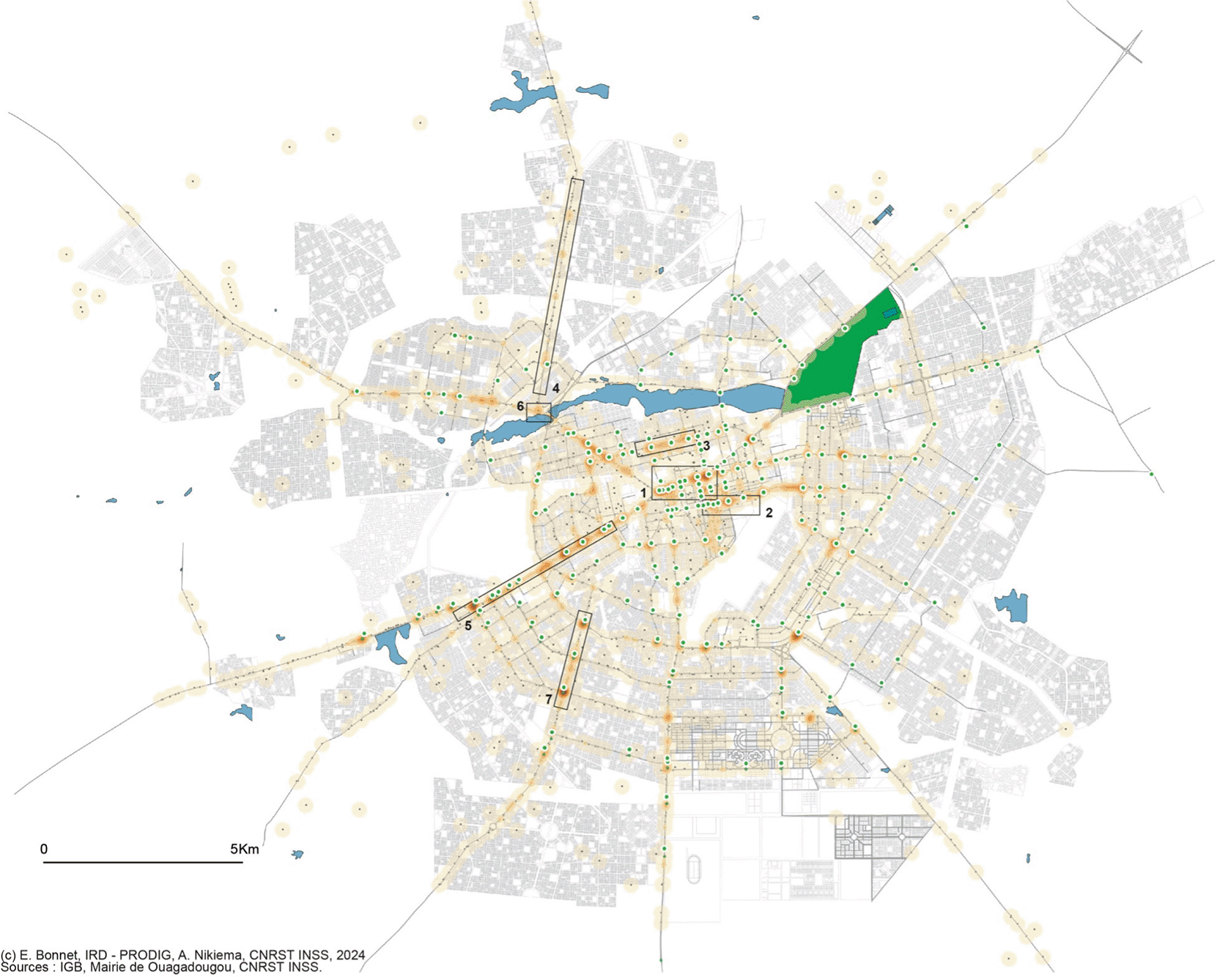
Seventy percent of the injured had their crash on an asphalted road ( Figure 2) and the highest concentration on the most recent roads. The spatial analysis of the density of casualties shows a concentration of road crashes on 4 axes already visible on the road traffic crash map: the road towards Bobo Dioulasso (1) and the road towards Kamboinsin (2), the Rue de la Liberté (3) and the Avenue de la Dignité (4). In addition, the Northern Interchange and associated arteries are complex to use with several access lanes around a circular road on the interchange (5), which confuses users unaccustomed to this traffic model. It is the only complex interchange of this type throughout the country.
The aim of this action-research project was to demonstrate the feasibility of data digitization by Ouagadougou’s road safety stakeholders to estimate the burden of crashes and their characteristics. The system and its appropriation by the players worked perfectly and produced unprecedented knowledge. As a result, the total burden is estimated at 4,766 casualties, based on data from the university hospitals. The total number of deaths, corresponding to the census of the National Police at the scene of the crash (n = 58), the number of deaths upon arrival in A&E (n = 85) and the number of people who died during their stay in the CHU (n = 63) amounts to a total of 206 persons.
Since 2010, WHO and the United Nations have regularly reviewed road safety and road injuries worldwide.2,3,19–21 All the reports mention the need to improve data capture so that every country can complement the WHO’s desired indicators, first and foremost the toll of dead and injured, and on the other hand, target priorities for action. The December 2023 report3 is no exception, but mentions new actions in Zambia, where data capture was opened to several actors as part of a Data for Health project.22 It is therefore a new positioning which tends towards the recognition that the results published in the reviews are far from reality especially for LMICs and that it is necessary to improve the capture and statistical models. The data appears to be both undervalued by countries and overvalued by WHO as many West African states claim.23 The Zambian study shows that the data of the various actors remain incomplete, but the researchers mobilize them in their statistical models to more accurately estimate the burden of crashes. This experience demonstrates the need to propose crash monitoring systems that integrate these actors, encourage them to participate in a collective collection to improve analysis of road crash and injury. This will make the data more complete and the statistical models more accurate.
The action research conducted in Ouagadougou specifically aimed to develop this type of monitoring system by mobilizing two major players in the capture of data for the estimation of the number of crashes, the number of injuries and deaths. The results show that data were entered in regular fashion and that actors were dedicated to the action research from the start.
This study, therefore, made it possible to assess the precise burden in terms of victims injured and deaths, but not to reach a global estimation of the number of crashes. We also identified the accident-prone points of the town, not seen in Ouagadougou since 2015. The systematic capture of data from two road safety actors with a view to supplying information for a road traffic monitoring system in west Africa is ineffective in any country. This research, therefore, demonstrates that this type of capture is possible at minimum cost, as we had already demonstrated with a single actor in 2015.7 We also demonstrate that the data issued by the national police force is not the most reliable for estimating the burden of crashes, in particular as regards health impacts, as well as the regularity of data gathering. The only ones who can do this are the hospitals.
This demonstration is important because to this day, the international data used by the WHO to establish its global assessments relies principally on data from the national police force. Incentives from international organisations regarding hospital data production would make it possible to avoid modelling based on unreliable data. Systematic data capture, together with the police, firefighters and hospitals, with common identifiers, would enable capture recapture methods to be used and estimate the complete burden of road traffic crashes. Results from this reseach appears useful at a time when other countries of the sub-region, Senegal, Côte d’Ivoire and Benin24 are putting forward their crash data digitization systems, but which are still mainly based on national police force data. Finally, if the data captured by the two actors are very different in tems of volumes and characteristics, they provide complementary information. The CHU data make it possible to estimate the burden of the number of injured victims and deaths, and an exact description of the traumas. The police data, even if they are incomplete, enable the drawing up of a basic map of accident-prone places, in the interest of prevention.
Much more than a statistical monitoring tool, this monitoring system removed the technological difficulties encountered in 2015 in a similar project,7 and proposed a simple technology for access, allowing not only a continuous assessment, a precise mapping, but also other potentialities identified by hospital actors. The system offers screening potentials from patients to the CHUs. The real-time collection of geolocation, of the number of cases in the A&E departments of the different CHUs could make it possible to optimize the distribution of patients according to the availability of the different emergency services. This research is in addition to other experiments conducted in Pakistan25 and Kenya where a trauma monitoring system was tested in 2 hospitals in Nairobi.26 These studies also demonstrated the feasibility of deploying such systems and their comprehensiveness in hospitals, in particular because of the involvement of stakeholders from the start of the project. Elsewhere in Kenya, in Kisumu, another pilot on an injury monitoring system confirms the feasibility of implementation in hospitals, the quality of the data obtained and the usefulness of epidemiological data for improving the health status of patients.27
However, our monitoring system is more open than these experiences since it also integrates data from the National Police and extends over a period of 12 months. However, it must be noted that not all police stations have been assiduous in capturing data. Indeed, after cleansing the data, we recorded 3,622 crashes out of the 4,000 entries into the system. In 2021 the statistics of the National Police indicated 12,401 road traffic crashes for the city of Ouagadougou alone.28 Although the study period is not comparable, data capture conducted by the police as part of this research was found to be low, even though a map of road traffic crashes hotspots and relevant statistics on a sample of crashes could be produced, the experience was inconclusive. As in 201529 National Police officers engaged in crash detection services, demand financial motivation to carry out the work and more considerations. Turnover of staff in police stations is a further difficulty in ensuring staff are trained in the use of capture tools and their continuity over time. Integrating road safety issues and monitoring tools into police academies would certainly be effective. Our action research in Ouagadougou, however, although rich in information about the quality of the data captured by the National Police, is biased because it is linked to the necessity to obtain a crash report from victims, mainly of material damage, to activate the process of insurance settlements. This is why 68% of the crashes recorded by the police concern cars. It seems to us that if the National Police is able to contribute to a comprehensive crash monitoring system, the principle reason is because of its ability to identify physical crashes and the location of road traffic crash-prone areas. It is more the BNSP (fire brigade) that would make it possible to better understand the human consequences in terms of deaths and casualties, since they take care of more than 60% of the injured admitted to the A&E. The 2020 BNSP report stated that it had taken care of 7,820 road injuries and 100 fatalities in the Ouagadougou region, an area larger than our study.30 Some of these casualties do not require hospital emergencies, which partly explains this high number. The integration of BNSP among the actors would make it possible to assess the number of casualties and deaths more accurately. Rethinking data capture by integrating all road safety actors into a common monitoring system would improve the estimation of the burden of crashes. It would also improve the results of statistical capture-recapture analyses used in numerous research projects in recent years, but which are often based on incomplete and short-term censuses.22,31–35
The main result of the research in Ouagadougou is the statistics produced from the three CHUs of the city. The capture was quasi-exhaustive (some short-term outages blocked a few hours of capture) and could rely on committed and motivated interns. The originality of our experience is that it is not a prospective survey carried out by investigators but by hospital practitioners, completing a digital register that supplies an injury monitoring system. The results are based on 4,766 patients admitted to A&E and have characteristics specific to Ouagadougou compared to other research in sub-Saharan Africa.25,26,36 It should be noted in particular that the medical care of road casualties suffers from several shortcomings. In the first place, the capacity of the BNSP is not sufficient for the number of casualties requiring transport (61%), leaving a quarter of those injured to travel on their own to the CHUs. This proportion is 10% for crashes classified 3 or 4 in terms of ISS (injury severity score), i.e. the most severe.37 In addition, the distribution between the CHUs is far from equitable, increasing the arrival times to A&E (the traffic is denser in the city centre) and the time it takes for patient care at the saturated A&E department at the Yalgado Hospital. The issue of pre-hospital care is a major problem in Africa,38 in particular because it is mainly left to the fire brigade, not having sufficient equipment in relation to the populations they are supposed to cover, and also by the first aid and medical skills of the firefighters on board for the interventions.39 An Emergency Medical Assistance Service (known as the SAMU in France) would enable medical treatment to be adapted for the most serious road traffic injuries. Senegal is an exception in West Africa with two SAMUs in the country, one in Dakar and the other in the Saint-Louis region.40
The main characteristics of road traffic crashes in Ouagadougou are essentially associated with users of two-wheel motorized vehicles. They represent 89% of patients admitted to A&E, this being a peculiarity of Ouagadougou which is already known41 and is confirmed here by this new study. Of these patients, 45% have head-injuries and are a reminder that while Ouagadougou is characterized by a strong presence of two-wheel vehicles, it is also characterized by a low rate of helmet wear,42 making these users particularly vulnerable. There is also a high prevalence of injury to the lower extremities. This high prevalence is also cited in other studies on road injuries in Africa.43 It also suggests an additional burden of incapacity to move and work for these types of injuries, including those categorized as non-serious, and generally on the financial consequences of road crashes.44
In terms of the severity of injuries, there is a very low proportion of injuries considered to be critical, and to some extent a low mortality rate in relation to the number of injured. The notion of severity is, however, to be considered with caution, since it is not evaluated in the registers by hospital doctors. We wanted to characterize severity on a scale that would allow for an AIS and an ISS computation, but interns were not trained in the skill, so we were finally able to differentiate with certainty two categories of injuries (Mild/Moderate and Severe to maximal). The majority of patients were considered to have light injuries, which can be explained by the slow traffic speed in the city and the separation of lanes between two- wheel vehicles and other vehicles thus reducing the most violent impacts.
The geography of road traffic injuries proposed in this study complements the analysis since it makes it possible to explain both the time it takes to mobilize the emergency services, the speeds travelled and to identify the most road traffic crashes-prone places. These elements are useful in targeting actions and thus reducing road traffic crashes and their consequences. For the past 5 years, Ouagadougou has developed new asphalted axes to relieve congestion of increasingly cluttered roads used by two-wheel motorized vehicles. The growth of the city has led to an extension in travel without changing its direction towards the city centre, which explains the constant exposure to road crashes. Mobility is a concern for the administrative authorities. They have developed various interventionist tools such as the Ouagadougou Mobility Support Project (PAMO), the Urban Travel Observatory (ODUO) or the traffic and parking plan while prioritizing traffic flow but without specific intervention for road safety. To do this, wide lanes have been multiplied on the outskirts.45 The new road developments have resulted in the extension of the circular boulevard to the south of the city, the widening of the axes connecting the national roads and the opening of new roads, in particular a bypass of the capital that extends beyond the municipal boundaries. The analysis of road traffic crashes -prone zones highlights a large number of hazardous junctions already observed in 2015.45 They correspond to relative non-compliance with traffic lights in the city.
The high densities of casualties at the interchanges as well as the peripheral axes, is significant in terms of behaviour on the roads. The lack of a driving licence, the lack of knowledge of traffic rules by road users, especially young people46 are recurrent. Another risk factor may be road development. Roads are often designed with no consideration of traffic and road occupation practices by populations. Research shows that the road infrastructure environment can contribute to driver failure.47 The particularity of asphalt roads in Burkina Faso is to exert a strong attraction on informal trade.48 This then requires pedestrians to walk on the roadway used by road users and vehicles to occupy part of the same roadway for parking. A situation that could lead to conflicts and potential crashes.
Our research encompasses some limitations. Mainly, we could not implement the capture recapture method, traditionally used to estimate the total number of road crashes, due to two reasons. First, the proportion of missing information on the victim’s characteristics (their age, for instance) prevented us from implementing the capture recapture method to estimate the global number of crashes. Second, the description of the location of the crash given by the patients admitted to hospital was not always precise, rendering matching the information with the police dataset challenging. This limitation underlines the importance of a comprehensive data capture system for road crashes.
Reducing the burden of road traffic injuries requires the availability of reliable data from all stakeholders. The multisectoriality of road safety in public policies is one of the major challenges when involving countries in systematic and effective monitoring of road crashes and their consequences. It is also a question of increasing public awareness of road safety regulations, in particular through educating the young about road safety, one of the axes of the national road safety policy which remains at the embryonic stage, despite its implementation since 2008.
This study was approved by the Institutional Ethics Committee for Health Research of the Institut de Recherches en Sciences de la Santé (IRSS), Burkina Faso (Decision No. 08/2020 of 27 January 2020). No personal identifiers were recorded; each entry received a unique code. Results are reported in aggregate form. Informed consent was obtained from all respondents. GPS data were restricted to event locations and did not allow household or individual identification.
Written informed consent was obtained from all participants prior to their inclusion in the study. The consent form was read aloud by physicians, and participants were also given the opportunity to read it themselves. Consent was documented by an electronic signature on a tablet, and all signed forms are securely stored in the study database. No children were enrolled, as pediatric cases are managed in another university hospital.
| Views | Downloads | |
|---|---|---|
| F1000Research | - | - |
|
PubMed Central
Data from PMC are received and updated monthly.
|
- | - |
Provide sufficient details of any financial or non-financial competing interests to enable users to assess whether your comments might lead a reasonable person to question your impartiality. Consider the following examples, but note that this is not an exhaustive list:
Sign up for content alerts and receive a weekly or monthly email with all newly published articles
Already registered? Sign in
The email address should be the one you originally registered with F1000.
You registered with F1000 via Google, so we cannot reset your password.
To sign in, please click here.
If you still need help with your Google account password, please click here.
You registered with F1000 via Facebook, so we cannot reset your password.
To sign in, please click here.
If you still need help with your Facebook account password, please click here.
If your email address is registered with us, we will email you instructions to reset your password.
If you think you should have received this email but it has not arrived, please check your spam filters and/or contact for further assistance.
Comments on this article Comments (0)