Keywords
SAR, remote sensing, mode of transportation, earth observation
This article is included in the Japan Institutional Gateway gateway.
SAR, remote sensing, mode of transportation, earth observation
The importance of transportation to national development is growing. It is a significant factor in determining patterns of production and commerce, and as a result, economic integration. It can also assist some nations in generating cash by offering transportation services.1 There is a need to detect and monitor the most current condition of transportation, especially the mode of transportation, the container types, as well as the related infrastructures. The information acquired can be used for taking immediate actions that will allow maintenance, mitigations, and sustainable development.
However, evaluating, monitoring, and detecting the mode of transportation is time-consuming expensive, and labour-intensive. The traditional way can only cover small scale and use in situ measurement techniques. One of the most famous methods that allow us to collect information on a large scale, time-efficient, and without direct interaction with the object is using remote sensing technologies. Especially Synthetic Aperture Radar (SAR) remote sensing, which can be operated day or night, penetrate clouds, and without weather issues because it uses microwave electromagnetic energy.
The length of microwave electromagnetic wave used in SAR remote sensing is between 1 centimetre to 1 meter. Similar to optical remote sensing, radar sensors also operate with one or more bands. It is identified by letters, such as P, L, S, C, X, K, Q, V, and W. The longest band is P with 100 cm of wavelength, while the shortest band is W with 0.3 cm of wavelength. On the contrary, the highest frequency is the W-band, with 100 GHz, and the lowest frequency is the P-band with 0.3 GHz.2
L band has higher penetration than C- or X-bands, therefore for mapping the volume of vegetation L- and C-band is better since they can be penetrated deeper into the vegetation canopy. While the X-band will scatter close to the surface of the vegetation canopy.3 When the frequency becomes lower, it can propagate with low attenuation and penetrate deeper, like the P-band that can penetrate several centimetres of the forest, dry ground, snow, ice, and the soil surface.4
Surface roughness affects the dark level of the produced SAR remote sensing image. Smooth surfaces like water bodies, roads, and other paved surfaces will produce a dark image since there is no return of backscatter signal due to it having a specular reflection. Rough surfaces like buildings, towers, tree trunks, and other vertical structures will produce a bright image since there is a strong return of backscatter signal due to it having diffuse scattering.3
SAR remote sensing is categorized as an active sensor and can be classified as an imaging sensor. The image produced using SAR remote sensing depends on the polarization of an electromagnetic wave. Different images will produce different visualizations if using different types of polarization. Polarization is the orientation of the plane of oscillation of a propagating signal.5 Concerning the Earth's surface, the perpendicular polarization planes are commonly referred to arbitrarily as horizontal and vertical. Polarization interacts differently with objects on the Earth’s surface, which leads to the different brightness levels recorded in a specific polarization channel.3
In SAR remote sensing the polarization uses abbreviations, such as horizontal transmission and horizontal reception (HH), vertical transmission and vertical reception (VV), horizontal transmission and vertical reception (HV), and vertical transmission and horizontal reception (VH).
One of the earliest generations of SAR remote sensing sensors is Canada’s RADARSAT program includes RADARSAT-1, RADARSAT-2, and the RADARSAT Constellation Mission (RCM). RADARSAT-1 (launched in 1995) and RADARSAT-2 (2007) operated in the C-band, offering high-resolution imaging for disaster monitoring, agriculture, and forestry. The RCM, launched in 2019, comprises three satellites that ensure daily global coverage, improving monitoring capabilities for Arctic regions, sea ice, and maritime safety. RADARSAT-2, with its ability to capture fine-resolution imagery, is also used for oil spill detection and urban mapping (https://www.asc-csa.gc.ca/eng/satellites/radarsat/).
Currently, there are many types of SAR remote sensing sensors available. One of the well-known is the Sentinel-1 SAR belonging European Space Agency (ESA). Sentinel-1 carries a C-band with dual polarization (HH+HV, VV+VH) and a temporal resolution of 12 days (sentinels.copernicus.eu). PALSAR-3 belongs to Japan Aerospace Exploration Agency (JAXA), revisit time is 46 days, and carries an L-band with multiple polarization (eorc.jaxa.jp). PALSAR with HH signal polarization can penetrate the forest canopy deeper and is returned from the bottom of the forest stronger than the VV signal polarization.6 TerraSAR-X is a commercial SAR remote sensing sensor belonging to the German Aerospace Center (DLR) with a 1-meter spatial resolution and temporal resolution of 11 days. TerraSAR-X carries an X-band, with a range of different modes of operation, allowing it to record images with different swath widths, resolutions, and polarizations (dlr.de).
Italy's COSMO-SkyMed constellation, developed by the Italian Space Agency (ASI), consists of four satellites operating in the X-band. These satellites provide rapid revisit times and high-resolution imaging for military and civilian applications, including disaster management, land cover mapping, and infrastructure monitoring. A second-generation COSMO-SkyMed constellation has been launched to enhance data quality and revisit frequency (https://portal.cosmo-skymed.it/CDMFE/home).
Other Asian countries also have launched SAR remote sensing sensors. It is India’s Radar Imaging Satellite (RISAT) series, including RISAT-1 (C-band) and RISAT-2 (X-band). These satellites are used for agricultural monitoring, disaster management, and surveillance. Additionally, the upcoming NASA-ISRO Synthetic Aperture Radar (NISAR) mission is a collaboration between NASA and the Indian Space Research Organisation (ISRO). Scheduled for launch in 2025, NISAR will operate in both L-band and S-band, making it the first dual-band SAR system. It is expected to provide unprecedented data for applications ranging from ice sheet dynamics to natural hazards (https://www.isro.gov.in/NISARSatellite.html).
South American countries also have SAR remote sensing sensors. The Argentine Space Agency (CONAE) developed the Satélite Argentino de Observación COn Microondas (SAOCOM) constellation, consisting of SAOCOM-1A and SAOCOM-1B. These satellites operate in the L-band and are primarily designed for agriculture and soil moisture studies. Their ability to penetrate soil makes them excellent for monitoring water content in agricultural fields, and improving crop management (https://saocom.invap.com.ar/).
With better spatial and temporal resolution, SAR remote sensing is suitable for transportation detection and monitoring activities. Many kinds of research used SAR remote sensing for the mode of transportation studies. Studies for monitoring the airport were done in 20017 and 2004.8 Studies for ship detection were introduced in 20039 and car detection in 200710 and 2016.11
As discussed, the remarkable capabilities of SAR remote sensing provide unprecedented opportunities to employ these technologies in a broad variety of modes of transportation studies. There are currently some SAR remote sensing literature review studies conducted. Gend and Genderen12 was the first comprehensive SAR remote sensing review paper conducted related to the Interferometric Synthetic Aperture Radar (InSAR). The author comprehensively discussed the issues, techniques, and application of InSAR. Ouchi13 has summarized the recent trends and advances in SAR remote sensing on various topics. A topic such as fields of applications, specifications of airborne and spaceborne SAR, and information content of interpretation, InSAR, and Polarimetric SAR (PolSAR). However, the review is too general and does not focus on transportation issues. Other references [14] also briefly discussed the remote sensing techniques for road evaluation. They concluded that remote sensing techniques offer new potential for pavement stakeholders to evaluate large areas in an efficient time. The authors provided comprehensive information about remote sensing technologies, not only SAR but also Ground Penetrating Radar (GPR), infrared thermography, LiDAR and terrestrial laser scanning, hyperspectral, and emerging technology such as mobile smartphones. Further, other references [15] also introduced the trend in commercial SAR remote sensing. They introduced high-resolution wide-swath capabilities, multi-polarimetry, and the development of increased bandwidth of SAR sensors. They also emphasized that the timely availability and delivery of SAR remote sensing data is important. Therefore, expanding the number of satellite constellations and ground station networks is needed to fulfil the requirement.
There is still a need for a more comprehensive and focused review to discuss various aspects of the application of SAR remote sensing for transportation studies. Thus, the main objective of this study is to 1) identify the trend and gaps in the use of SAR remote sensing technologies for them to be easily adopted by transportation stakeholders; and 2) to classify the use of various SAR remote sensing technologies regarding the information they can provide in various mode of transportation detection, evaluation, and monitoring.
I used three scientific databases for a systematic search strategy. The databases are Web of Science (https://www.webofscience.com/), IEEE Xplore (https://ieeexplore.ieee.org/), and ScienceDirect (www.sciencedirect.com). Within the Web of Science and ScienceDirect database, only article document types were selected, while proceedings, books, or book chapters were excluded. While within IEEE Xplore, only journals type were selected, while conferences and magazines were excluded. Table 1 shows the keyword used to search the scientific papers.
| Databases | Address | Keywords |
|---|---|---|
| Web of Science | https://www.webofscience.com/ | (TS=(SAR) OR TS=(Synthetic aperture radar) OR TS=(remote sensing) OR TS=(airplane) OR TS=(aircraft) OR TS=(airport) or TS=(runway)) AND (TS=(ship*) OR TS=(port) OR TS= (harbor) OR TS=(car*) OR TS=(truck*) OR TS=(train*)) AND (TS=(terminal) OR TS=(parking) OR TS= (station) OR TS=(railway) OR TS=(vehicle) OR TS=(vessel)) |
| IEEE Xplore | https://ieeexplore.ieee.org/ | “All Metadata”: SAR AND Synthetic aperture radar AND remote sensing AND airplane AND aircraft AND airport AND runway AND ship AND port AND harbor AND car AND truck AND train AND terminal AND parking AND station AND railway AND vehicle AND vessel |
| Scopus | www.sciencedirect.com | TITLE-ABS-KEY(“SAR” OR “Synthetic aperture radar” OR “remote sensing” OR “airplane” OR “aircraft” OR “airport” OR “runway”) TITLE-ABS-KEY(“ship” OR “port” OR “harbor” OR “vessel”) TITLE-ABS-KEY(“car” OR “truck” OR “train” OR “railway” OR “vehicle”) |
This study focuses on the trend of SAR remote sensing in modes of transportation. Therefore, only the articles or journals from 1990 to 2022 were selected. The preferred reporting items for systematic reviews and meta-analyses (PRISMA) framework was adopted (https://www.prisma-statement.org//).
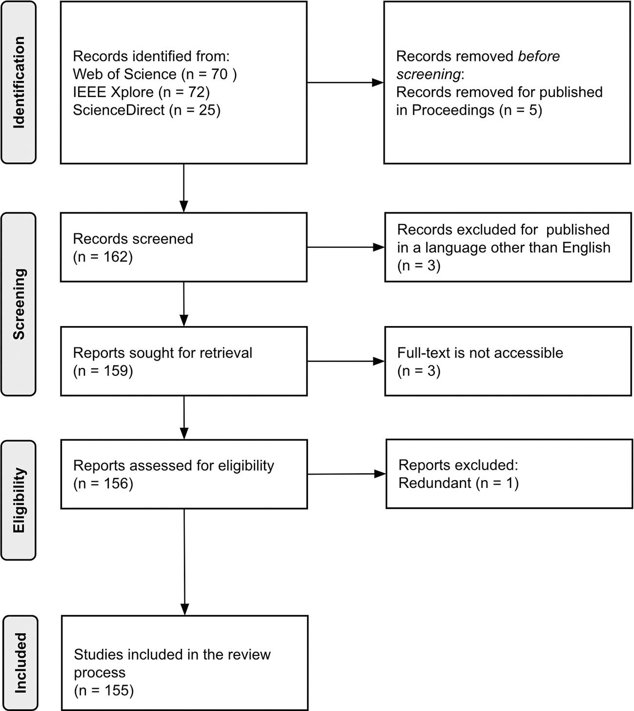
In the identification phase, there are 167 articles in total were collected. There are three articles published in languages other than English, and there are five articles published in Proceedings. Furthermore, there are three articles where full text was not accessible and one article is redundant. Thus, all of these articles were eliminated. Finally, there are 155 articles and journals were selected for the review process. Figure 1 shows the PRISMA flow diagram of this study.
The selected articles and journals were then classified into five classes related to the review objectives. The first topic was the classification of the different modes of transportation. The different modes of transportation are air, land, and water. The second classification is the container of the mode of transportation, which includes aeroplane, car, truck, train, and ship or vessel. Then, the third classification is the infrastructure of the mode of transportation such as airport, runway, road, railway, port, and harbour, The fourth and fifth classifications are geographic distribution and publication pattern. Table 2 summarises the classification of topics used in this review study.
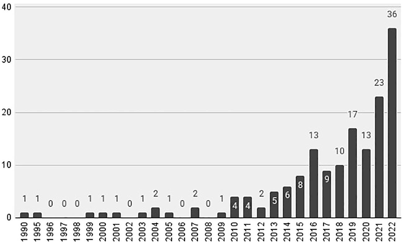
Based on the result, the first article that discussed ship detection was published in 1990.16 Then the utilization of SAR remote sensing for modes of transportation was relatively stagnant for two decades. After 2009, the result of the analysis showed that the utilization of SAR for modes of transportation gradually increased. After 2014, the utilization of SAR remote sensing increased dramatically. It is the open public policy by the European Space Agency (ESA) that makes the availability of the Sentinel-1 mission open to the public. Consequently, the adoption of SAR remote sensing for modes of transportation research is increasing by up to 36 articles by the year 2022 ( Figure 2).
Our result found that most of the studies were conducted in the Asia region, especially in China (30), Korea (10), Hong Kong (6), Singapore (4), Japan (4), and Taiwan (3). The second most studies were conducted in the European region, especially Spain (7), Italy (4), and the United Kingdom (3). The last region is North America, where there were 6 studies conducted using SAR for the mode of transportation analysis. However, there are many articles or journals did not specifically mention the study area.
The most studied ship detection was in the busiest strait such as the Strait of Gibraltar,17–21 Singapore and Malacca Strait,18,22–24 and South Korea,25–27 Gulf of Guinea,28 and Canada.29 While the studies of airports, aircraft, and related things are mostly conducted in China.7,8,30–49,37,38 There are few studies on airports conducted in Turkey50 and South Korea.51 The studies on railways were mostly conducted in China52–56 and a study in the Netherlands.57 While the studies of roads, vehicles, and related things were conducted in European countries,58 China,59 and Thailand.60
Interestingly, this finding is informed us that the study of using SAR for the mode of transportation mostly conducted in the northern part of the equator ( Figure 3). We assumed that it is due to the developed countries mostly being located in the northern part of the equator. They have the most developed mode of transportation and need to detect, evaluate, and monitor the condition of the infrastructures such as airports,31–35,40,49 railways,52–57 and harbours.61–63
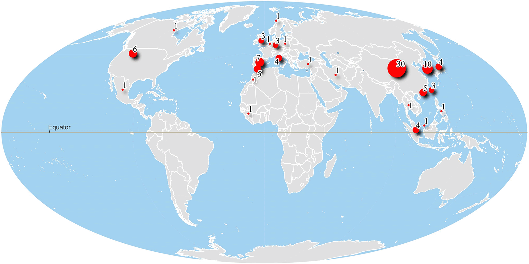
This figure was created using QGIS-LTR Desktop version 3.28.10-Firenze.
Most articles were published in the IEEE Journal of Selected Topics in Applied Earth Observations and Remote Sensing (23), followed by IEEE Geoscience Remote Sensing Letter (22), and Remote Sensing (19) and open access journal by Multidisciplinary Digital Publishing Institute (MDPI)
According to our findings, the first journal that published an article related to SAR remote sensing for the mode of transportation is IEEE Transaction on Geoscience and Remote Sensing in 1990.16 However, it took 14 years to publish the second article64 related to SAR remote sensing for the mode of transportation in the same journal. This journal is the fourth most published article in the SAR remote sensing for the mode of transportation. Figure 4 summarises the top ten journals that published articles related to SAR remote sensing for the mode of transportation in alphabetical order.
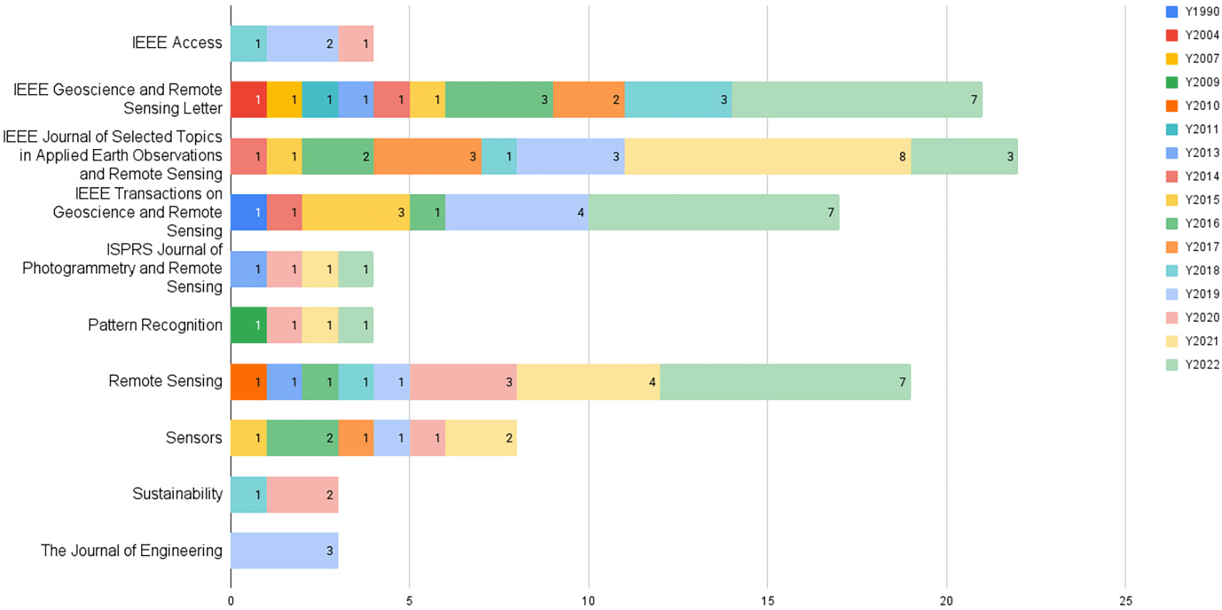
Open-access journals like Remote Sensing, Sensors, and Sustainability have become more popular as a place to publish studies related to SAR remote sensing for the mode of transportation.
As it is visualized in Figure 5, the water mode of transportation is the most frequent that is assessed and evaluated with SAR remote sensing (63.9%). Followed by air and land, with 20% and 16.1%, respectively. The main reason why the water mode transportation is the most frequent is due to the data characteristics of SAR remote sensing. The ship as the target of classification is located on a homogeneous water background, making it easier to analyse. compared to aircraft or cars which have a more heterogeneous background.

The result of the container of the mode of transportation is shown in Figure 6. According to the analysis of the result, most of the studies using SAR remote sensing in the mode of transportation are mostly for ship detection (75), car (14), aeroplane (5), and truck (1). As we explained earlier, ship detection is relatively easier compared to other modes of transportation. Since it is located in the water, with a homogenous background. Figure 7 visualized the condition of the Singapore Strait with the large number of ships in the water. The seasonality of the ship from April to September 2022 is represented in rainbow colour.

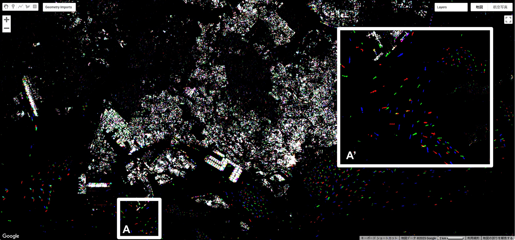
Ships are represented in rainbow colours. Processed using Google Earth Engine (GEE) by authors. A’ is a zoom-in area of A, allowing readers to more clearly see the presence of the ship.
Currently, studies on ship detection using SAR remote sensing are focused on speed and accuracy,65,66 and only a few studies to detect ships in multiscale67,68 and in complex backgrounds.67,69,70 Thereafter, future studies are expected to cover ship detection in multiscale and in a more heterogeneous background. Furthermore, most studies were conducted to detect stationary containers, few studies were conducted to detect moving containers.64,71–73,73–77 Future studies are expected to cover moving containers. Regarding the sensor used to detect the ships or vessels, most studies used satellite-based sensors. Only a few studies used airborne sensors.78,79
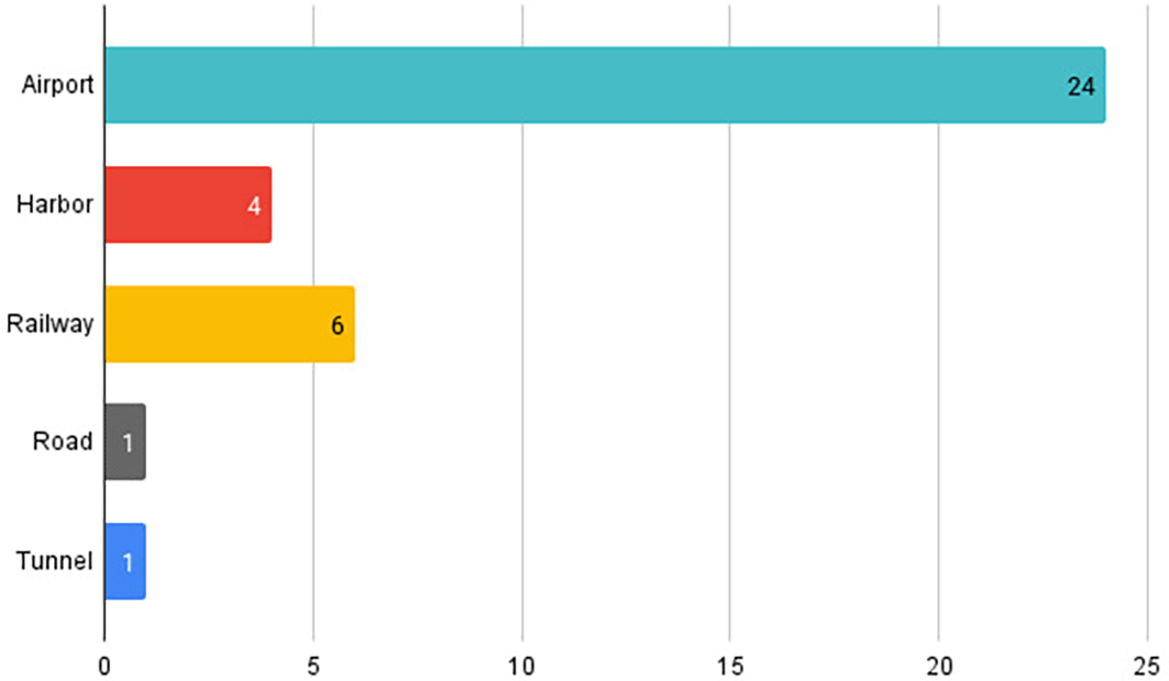
Figure 8 shows the result of the infrastructure of the mode of transportation. Surprisingly, the airport as the air mode of transportation become the most studied object (24). Where the railway as the land mode of transportation is the second most studied (6), the harbour as the water mode of transportation was the third most studied object (4), and road and tunnel as the land mode of transportation are the least studied, with only one paper each.
The Differential Interferometric Synthetic Aperture Radar (DInSAR) method has been widely used in studies aimed at monitoring transportation infrastructures, as highlighted by numerous works in the literature.7,8,27,30,43,45,46,48,50,52,80–82 This method is particularly valuable because it enables researchers to detect and measure the three-dimensional displacement of transportation infrastructure over time, providing a detailed time series of movement or deformation. The capability to track such displacements is crucial for understanding the structural stability and functionality of infrastructure systems, such as roads, railways, bridges, and airports which are integral to modern transportation networks ( Figure 9).
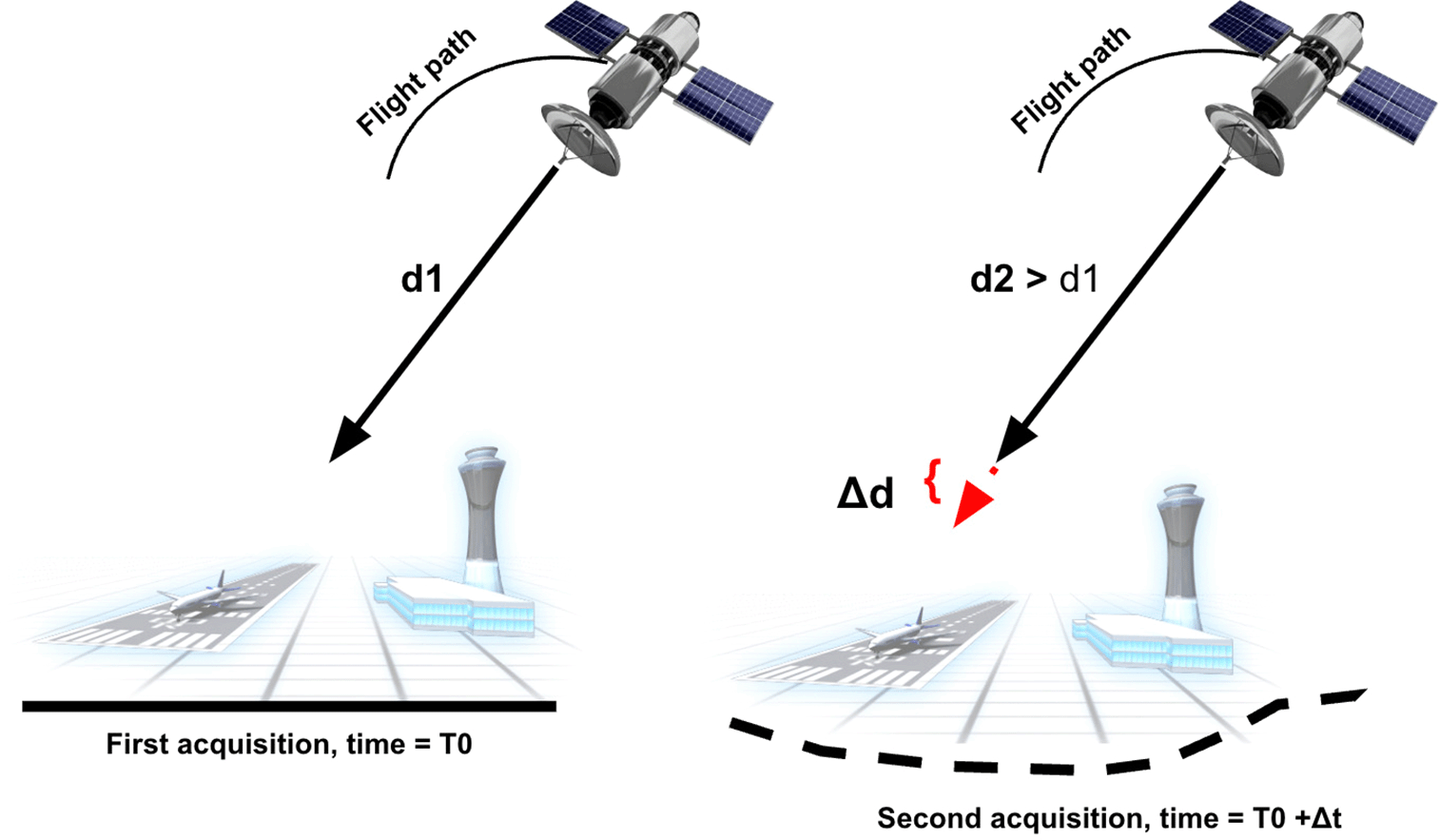
The DInSAR process involves using two radar images of the same area, captured from slightly different vantage points by a satellite or airborne radar system. These images are acquired at different times, and their slight positional difference creates a phase shift in the returned radar signals. This phase difference arises because the radar signals travel slightly different distances to and from the sensor, a phenomenon referred to as the "range difference." By analyzing the phase differences between the two images, researchers can derive critical height and displacement information about the study area.
To create an interferogram, which is the core product of the DInSAR technique, the phase differences between the two radar images are processed. The interferogram visually represents these differences, and with further processing, it can reveal subtle ground movements or deformations in the monitored area. These deformations are often caused by natural processes, such as earthquakes, landslides, or subsidence, or by human activities, such as construction or mining.
The utility of DInSAR lies not only in its ability to detect minute displacements but also in its capacity to do so over large areas with high spatial resolution. This makes it an indispensable tool for transportation infrastructure monitoring, as it helps engineers and policymakers assess potential risks and develop mitigation strategies. For instance, runways of airports experiencing subsidence in a specific section could be identified early using DInSAR, allowing maintenance efforts to be targeted effectively, thereby minimizing risks to public safety and reducing economic losses.
After 2010, the use of neural network classifier algorithms gained significant popularity in applications of Synthetic Aperture Radar (SAR) remote sensing for analyzing container modes of transportation. This marked a shift from earlier methods that required more human intervention in feature extraction and classification. Neural networks became a preferred choice because of their ability to model complex patterns and relationships within data, improving the accuracy of classification tasks.23,37,42,77,83–93
However, a new trend emerged between 2018 and 2022, as advancements in computational power and algorithmic research propelled the adoption of deep learning classifier algorithms for SAR applications.41,58,94–98 Deep learning, which is a subset of machine learning, relies on artificial neural networks with many layers (also called deep neural networks). Figure 10 demonstrates the principle of this approach, where the deep learning algorithm autonomously performs feature extraction, labeling, and classification without requiring manual intervention. This self-learning capability is achieved through interconnected layers of nodes, which process and transform data hierarchically to identify patterns and generate outputs.18,66,95,96
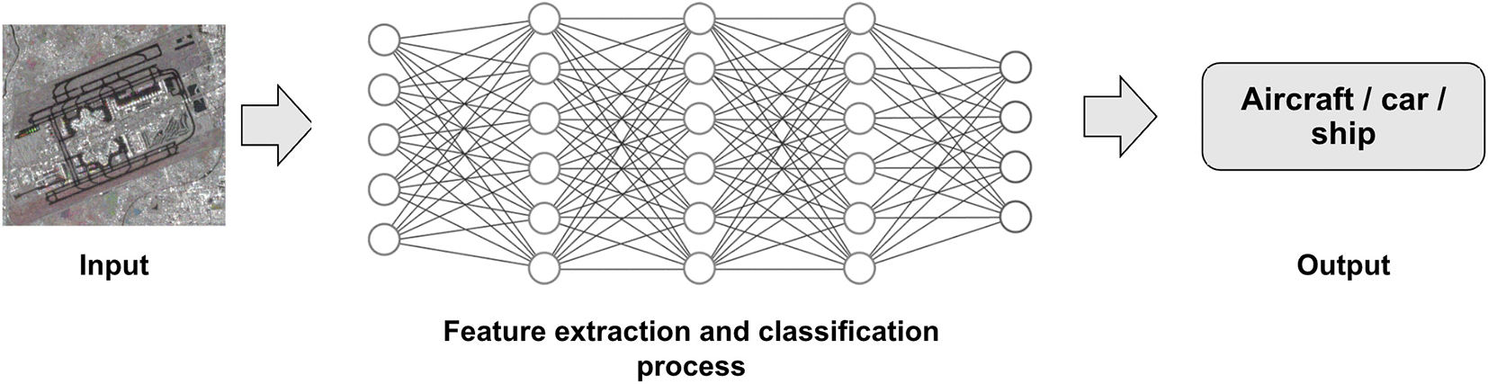
Where there are many layers and connected nodes used to extract the feature information and process the classification.
Neural networks and deep learning algorithms fall under the category of two-stage object detection algorithms. These algorithms follow a sequential approach: in the first stage, they generate candidate regions where objects might exist, and in the second stage, they refine these regions by classifying objects and determining their precise positions.
In contrast, one-stage object detection algorithms simplify this process by directly generating the target object's category and positional information in a single step. This streamlined approach is faster and more efficient, making it particularly useful for real-time applications. Examples of popular one-stage object detection algorithms include the Single Shot Multibox Detector (SSD)99–101 and the You Only Look Once (YOLO) series.102–105 These algorithms have gained widespread use due to their ability to balance speed and accuracy, which is essential for tasks like detecting and tracking objects in SAR data.
The progression from neural networks to deep learning, and the subsequent emergence of one-stage object detection algorithms like SSD and YOLO, reflects the rapid evolution of machine learning techniques in SAR remote sensing. These advancements have transformed how data is analysed, enabling more automated, accurate, and efficient processing methods.
Figure 11 shows the taxonomy of SAR remote sensing for transportation studies. In the studies related to infrastructures of transportation, most research uses the DinSAR methodology. While in the studies related to the container can be divided into two sub-classes; traditional and modern methodology. In the traditional methodology, most research utilized the backscatter, polarization, geometric, and feature-based. In the modern methodology, there are two sub-classes; one-stage and two-stage methodology.
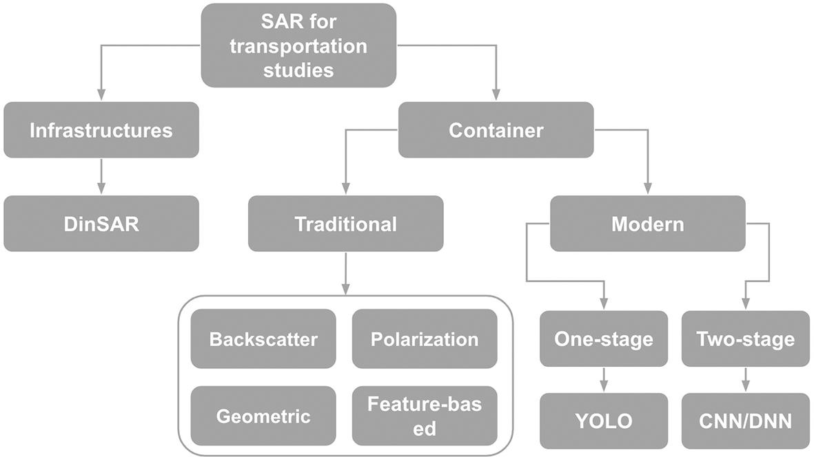
The one-stage methodology is designed to be simple and fast. It combines all the steps required for a task, such as locating objects and classifying them, into a single process. This approach is direct and efficient, making it suitable for applications that need quick results, like object detection of modes in transportation studies. However, because everything happens in a single step, the predictions might not be as refined or precise as those made using a two-stage approach. Examples of one-stage deep learning models include YOLO and SSD.
The two-stage methodology takes a more careful and detailed approach by splitting the process into two distinct steps, region proposal and classification. This two-step process makes the two-stage methodology slower than the one-stage approach but often more accurate. It allows the system to refine its predictions by carefully analysing the regions of interest. Models like Faster Region-Convolutional Neural Network (R-CNN) are examples of the two-stage methodology, often used in applications where precision is more critical than speed, such as detailed object analysis of transportation modes.
Synthetic Aperture Radar (SAR) remote sensing has been extensively utilized in transportation studies for over three decades, contributing significantly to monitoring and understanding various modes of transportation. The evolution of SAR sensor technology, coupled with advancements in algorithm development, has enabled the application of SAR in this domain. Moving forward, the role of SAR remote sensing is anticipated to expand, particularly in the detection and monitoring of moving transportation objects such as vehicles, ships, and aircraft.
Most transportation systems studied using SAR remote sensing are concentrated in the Northern Hemisphere, where the most developed transportation networks are located. This geographic focus reflects the higher demand for advanced transportation research in industrialized and densely populated regions. Among the different modes of transportation, maritime transportation has been the most extensively studied. The primary reason for this lies in the strong contrast between the ship, as the detected object, and the surrounding sea, which serves as a relatively homogeneous background. This distinct contrast makes ship detection more feasible and reliable using SAR. However, future research aims to address the challenges of detecting ships in more heterogeneous backgrounds, such as coastal areas or inland waterways, where the environment is more complex.
When it comes to transportation infrastructure, SAR studies have primarily focused on airports, followed by railways and harbours. Airports are often studied due to their critical role in global transportation networks and their vulnerability to environmental changes, such as land subsidence. The Differential Interferometric Synthetic Aperture Radar (DInSAR) method has been the most commonly employed technique for monitoring transportation infrastructure. By using time-series SAR data, DInSAR allows researchers to detect and measure land subsidence in three dimensions. This capability is invaluable for assessing the stability and safety of transportation infrastructure, particularly in areas prone to geological or environmental changes.
In terms of algorithms, significant advancements have been made in the last decade. Neural network algorithms began to gain traction after 2010, revolutionizing how SAR data is processed and analysed for transportation studies. More recently, deep learning techniques have emerged as the state-of-the-art approach for detecting and monitoring modes of transportation. These methods are highly effective in identifying complex patterns in SAR datasets, enabling the accurate detection of transportation objects and activities. However, deep learning is computationally intensive, requiring significant processing power and time. Therefore, future research must balance the trade-offs between accuracy and computational efficiency when applying deep learning algorithms to SAR data from diverse sources.
SAR's potential in transportation studies continues to grow, driven by technological advancements and the increasing availability of diverse SAR datasets. Future research is likely to focus on improving detection capabilities in complex environments, enhancing algorithm efficiency, and expanding the scope of applications to include emerging transportation technologies and systems.
| Views | Downloads | |
|---|---|---|
| F1000Research | - | - |
|
PubMed Central
Data from PMC are received and updated monthly.
|
- | - |
Provide sufficient details of any financial or non-financial competing interests to enable users to assess whether your comments might lead a reasonable person to question your impartiality. Consider the following examples, but note that this is not an exhaustive list:
Sign up for content alerts and receive a weekly or monthly email with all newly published articles
Already registered? Sign in
The email address should be the one you originally registered with F1000.
You registered with F1000 via Google, so we cannot reset your password.
To sign in, please click here.
If you still need help with your Google account password, please click here.
You registered with F1000 via Facebook, so we cannot reset your password.
To sign in, please click here.
If you still need help with your Facebook account password, please click here.
If your email address is registered with us, we will email you instructions to reset your password.
If you think you should have received this email but it has not arrived, please check your spam filters and/or contact for further assistance.
Comments on this article Comments (0)