Keywords
Social Cartography, Paramo, Peasant Community, Environmental Problems
This article is included in the Ecology and Global Change gateway.
Social Cartography, Paramo, Peasant Community, Environmental Problems
The Sumapaz paramo complex, situated on the eastern flank of the Colombian Andes at elevations ranging from 3,200 to 3,800 meters above sea level, covers over 333,000 hectares (Garavito González et al., 2018), making it the largest high-mountain ecosystem in the world and the most significant paramo region in Colombia. Of this area, 210,739 hectares are protected as the Sumapaz National Natural Park. Within this protected area, the municipality of Pasca holds 1,598.19 hectares of the park and an additional 11,422.79 hectares of paramo ecosystem, where most of the population is engaged in agriculture and livestock activities. The present study concentrates on the environmental and socio-territorial dynamics in this locality.
The Sumapaz paramo’s critical national importance is attributed to its ecological, agricultural, and hydrological functions. Its unique flora and endemic fauna sustain ecological balance, its agricultural aptitude supports food production, and its hydrological services contribute to potable water provision (Hernández Florez et al., 2009). However, the ecosystem is highly vulnerable to disturbances, recovering slowly from impacts due to climate change and anthropogenic activities, notably temperature shifts, humidity fluctuations, and extreme precipitation events (Garcia Bustamante & Leal Espear, 2019).
Historically, state-sponsored colonization, especially during the liberal administrations of Enrique Olaya Herrera and Alfonso López Pumarejo, enabled settlers to claim land rights in Sumapaz and facilitated intensified agricultural use in the region (Comisión de la Verdad, 2019). Since then, the agricultural frontier has expanded, transforming natural landscapes and exposing weaknesses in territorial governance (Morales-Betancourt & Estévez-Varón, 2006).
Scientific studies (Daza Torres et al., 2014) list a suite of major environmental pressures affecting paramo ecosystems, including: Slash-and-burn land clearing, Logging, Potato monoculture, Cattle ranching, Aquatic ecosystem eutrophication, Mining, Unregulated tourism, Road construction, Biodiversity loss, Unsustainable hunting/fishing and Invasive species proliferation.
Typically, policymakers and environmental discourses cast rural communities as primary threats to biodiversity and water, but this view reduces their cultural and economic relationships with the land to a simplistic source of environmental problems and erases their identity and livelihoods (Méndez Polo, 2019).
Therefore, social cartography is proposed as a research approach to visualize, exchange, and better understand rural communities’ perceptions of environmental issues beyond their roles as agricultural producers. Employing participatory and qualitative methods that encourage active community involvement is essential in designing more effective conservation strategies that both conserve the ecosystem and dignify its people (Bustamante Toro & López Castaño, 2024).
In this study, social cartography facilitated knowledge creation across a diverse group of actors: local youth, rural parents, and university researchers, collectively mapping environmental issues as perceived by the community. The research further explores how environmental conflicts in the paramo reflect more complex social problems, including stigmatization, marginalization, poverty, food security, state neglect, territorial fragmentation, and weak governance.
This study took place in the municipality of Pasca, Cundinamarca, Colombia (see Figure 1). Pasca adjoins Bogotá (Province 20 Sumapaz) on the east, Sibaté and Soacha to the north, Fusagasugá to the west, and Arbeláez to the south, covering more than 264 km2 and elevations between 2,180 and 3,900 meters, with average temperatures from 8–15°C (Fonseca Carreño, 2021).
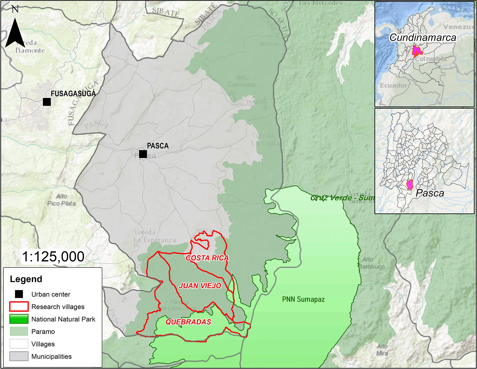
Source: Authors.
Pasca is part of the broader Sumapaz province, a vital hydrological region through which the Sumapaz River flows (Albarracín-Zaidiza et al., 2019). The regional economy is primarily rural and agricultural, focused on maintaining production/consumption balances for family sustenance (Santacoloma-Varón, 2015), though recent years have seen emerging tourism and environmental services (Bermúdez et al., 2017).
Within Pasca, 1,598.19 hectares fall under Sumapaz Natural Park protection, itself spanning over 210,000 hectares across Bogotá, Cundinamarca, Meta, and Huila (Rivera Valderrama et al., 2018). Pasca also encompasses 11,422.79 hectares of Sumapaz–Cruz Verde Paramo, the world’s largest paramo and a region of immense biodiversity and water provision significance (Daza Torres et al., 2014).
The research focused on peasant communities inside or contiguous to the paramo zone and National Natural Park. The study, illustrated in Figure 1, selected the villages of Costa Rica, Juan Viejo, and Quebradas.
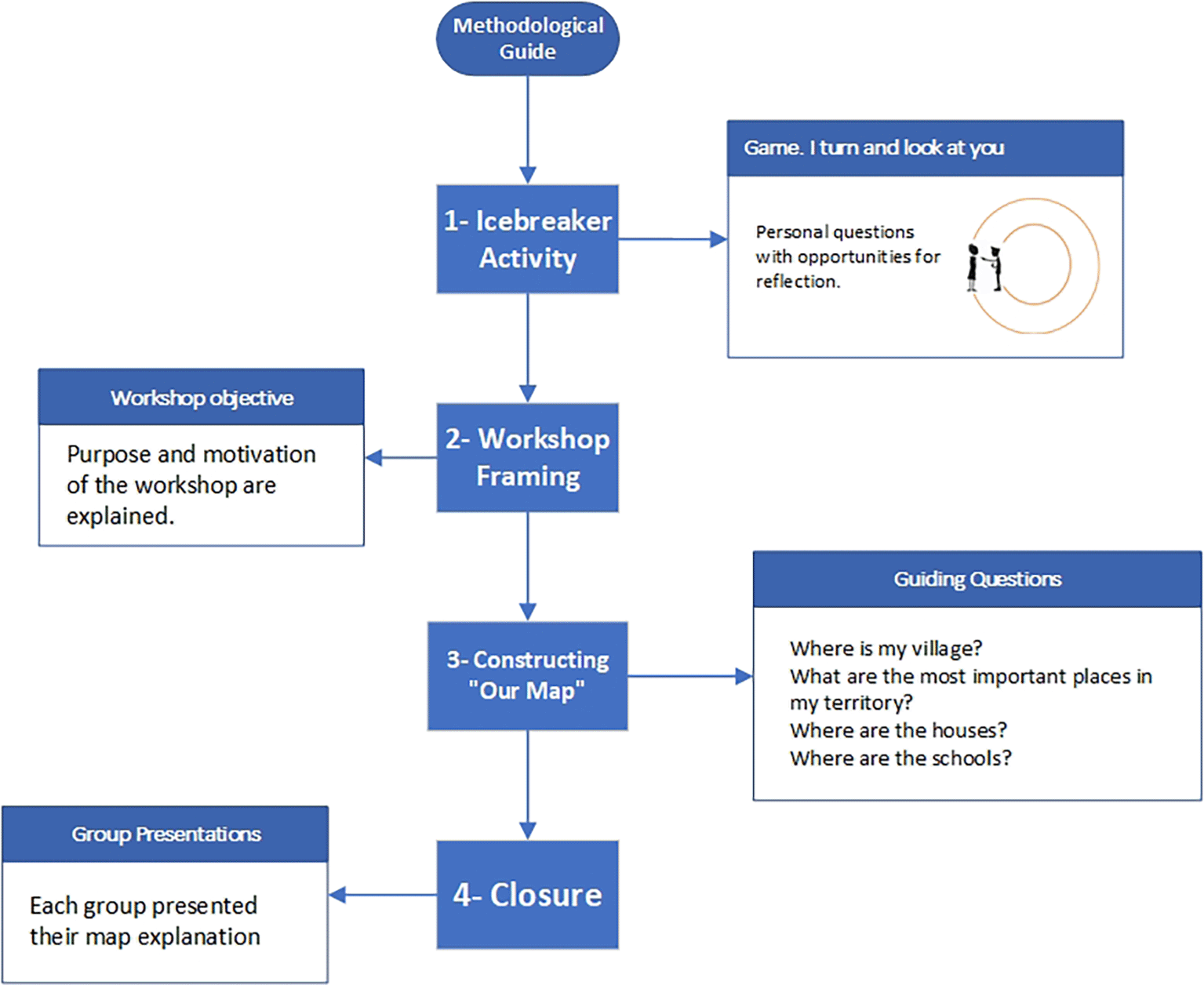
Social cartography was essential in this research as a participatory and collaborative tool for interpreting territorial dynamics and constructing knowledge dialogs (Ospina Mesa et al., 2021). Two participatory workshops were designed.
First Workshop: Engaged secondary school students (ages 10–15) from Costa Rica, Juan Viejo, and Quebradas. Participants self-identified by gender and worked in groups accordingly.
Second Workshop: Conducted at Costa Rica’s primary school, included both children and their parents, separated by gender into groups of girls and mothers, and boys and fathers (see Table 1).
Participation emphasized local voices over those of external facilitators, aiming for representation and inclusion as described by Barragán Giraldo et al. (2020).
The participatory approach was rooted in creative, playful, and collaborative engagement principles “creating while playing and co-producing collectively” (Diez Tetamanti, 2018). Data collection through social cartography followed a carefully structured process, supported by a methodological guide that contained four primary stages (see Figure 2).
Source: Authors.
Stage One: Icebreaker Activity
A trust-building game was developed, bringing participants together in two concentric circles to share about themselves while passing a ball to music—a pedagogical didactic used to stimulate group confidence and collective work (Tamayo Giraldo & Restrepo Soto, 2017).
Stage Two: Workshop Framing and Group Organization
Each participant was introduced, and the workshop’s research-driven goals (understanding territory and environmental issues) were explained (Diez Tetamanti, 2018). Small group organization (max 8 per group) was prioritized to ensure active engagement (Barragán Giraldo & Amador Báquiro, 2014). Details of composition by village and gender are found in Table 1.
Stage Three: Constructing “Our Map”
Participants, in groups, produced visual maps of their environment using diverse materials (cardboard, markers, magazines, etc.), guided by predefined prompts and adaptable questions (Betancurth Loaiza et al., 2019). Table 2 presents the key guiding questions.
Stage Four: Group Presentations and Closure
The workshop closed with group presentations, where participants narratively explained their maps, including legends, symbols, and identified environmental problems. This phase fostered reflection, group validation, and knowledge exchange (Diez Tetamanti & Rocha, 2016).
In this study, informed consent and assent for the participation of minors and their parents were obtained verbally. This methodological decision was made in response to the context of violence, the presence of illegal armed groups, and state repression affecting rural communities in the Sumapaz paramo. During the workshops, the research team presented the planned activities to the parents gathered at the school and requested written consent; however, the parents refused to sign any documents, instead granting their authorization verbally under the explicit condition that neither adults nor minors would be required to sign or provide any personal or identifying information.
This reservation is rooted in the climate of fear and insecurity caused by the assassination and persecution of social leaders in Colombia—with 170 cases reported in 2024 alone—as well as the risk of stigmatization or legal prosecution for traditional practices such as hunting, fishing, and wood extraction, which have been part of local livelihoods for over half a century but are now criminalized as environmental offenses. Therefore, verbal consent was an indispensable ethical condition to ensure the safety and informed participation of the peasant community, protecting their identities and rights throughout the research process.
Research on Colombian paramos consistently points to severe ecological degradation owing to unsustainable land practices outside the agricultural frontier. Key damaging activities in Sumapaz are potato monoculture, cattle grazing, small-scale mining, indiscriminate logging, illegal flora/fauna extraction, soil erosion, reduced water retention, and pollution from fertilizers/herbicides (Garavito Rincón, 2015). The present study focused on documenting how paramo-resident peasants, outside the formal agricultural zone, perceive and experience these environmental problems—through the participatory production of social cartographies.
Juan Viejo Village: Located entirely within the paramo, Juan Viejo’s livelihoods center on potato farming and dairy cattle. The community burns household waste, including herbicide containers. The CAR has designated buffer/conservation zones perceived as “true wasteland” subject to strict use controls. Despite restrictions, residents depend on trout fishing and hunt small games (e.g., ducks, rabbits, borugos) for food (see Figure 3). Evidence of tree felling (for home repair) and recurring fires (cause unclear) was present. Small-scale mining supports local road maintenance. There has also been a notable increase in tourism (4x4s, bikes, hiking), raising new environmental concerns.
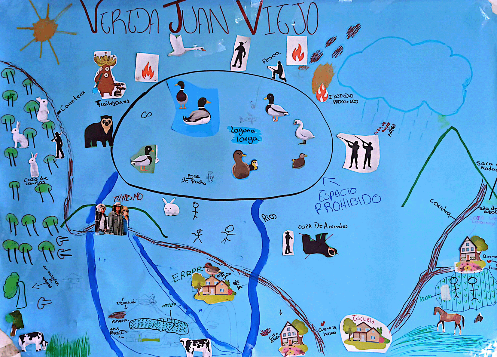
Source: Authors.
Quebradas Village: This village, adjacent to the park and situated within the paramo, shares similar patterns: intensive potato and cattle production (lower zones), burning of waste, and hunting/fishing. Youth cartographers highlighted hunting of rabbits, borugos, and deer, as well as trout fishing in specific streams (El Soche, Long, Black). Unregulated tourism was recognized as a growing issue. Notably, access to some upper/remote areas was restricted due to rumors of armed group presence, resulting in both insecurity and a disrupted relationship with the environment (see Figure 4).
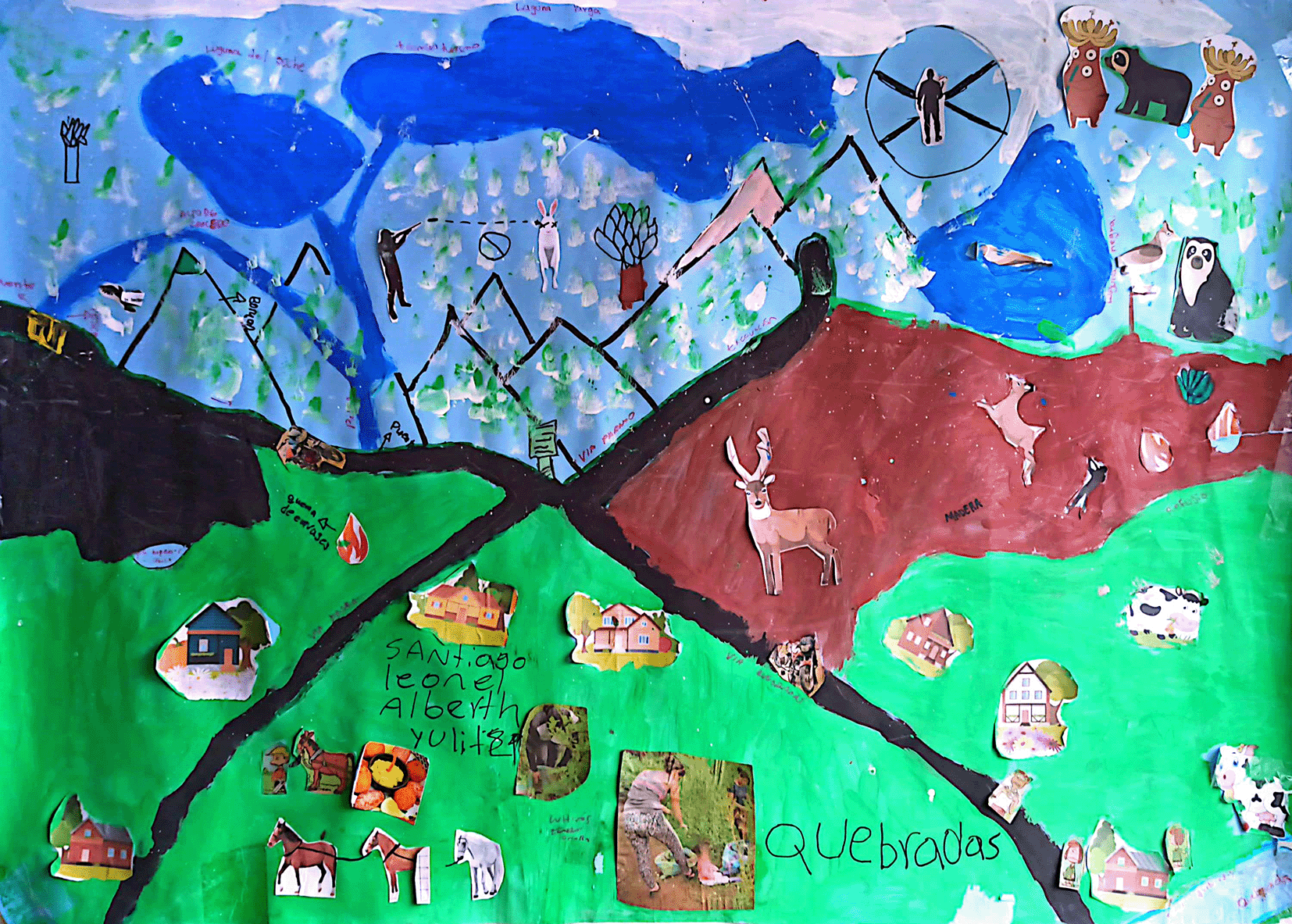
Source: Authors.
Costa Rica Village: Four maps from two workshops revealed nuanced, gendered, and generational perspectives. Youth groups (see Figure 5: A and B) depicted agricultural and livestock dependence, widespread burning of waste, river contamination by agrochemical runoff (notably herbicides), hunting and fishing for subsistence, tree felling, and tourism-generated trash left behind (a wildfire source).
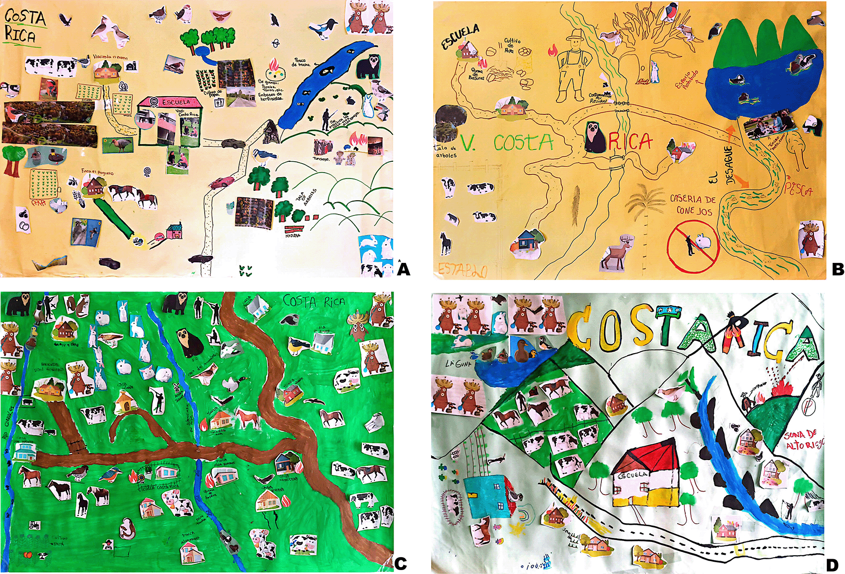
A) workshop #1 for young people (women) between 10 – 15 years old. B) workshop #1 youth (Men) between 11 – 15 years old. C) workshop #2 Women (Mothers and daughters). D) Workshop #2 Man (Fathers and Children).
Source: Authors.
Adult groups produced differentiated narratives:
• The mothers/girls group ( Figure 5: C) repeated concerns over waste disposal, subsistence farming, hunting/fishing, but did not mention tree felling.
• The fathers/sons group ( Figure 5: D) focused on wildfires in the upper paramo and trout fishing, but omitted hunting and agrochemical contamination. Uniquely, they marked “prohibited zones” connected to rumors of armed groups.
Across sites, findings demonstrate convergence in local perception: agriculture, livestock, burning waste (with associated agrochemical pollution), hunting/fishing, selective tree felling, the impact of unregulated tourism, insecure zones (due to armed groups), and shifting access to land/resources. Notably, tourism—though seen as a recent economic opportunity—frequently generates environmental hazards through unmanaged campfires, litter, and erosion.
Pasca’s peasants have long depended on potato farming and dairy cattle for survival—a pattern the participatory maps confirm. Locally, these activities are not widely regarded as environmentally destructive, but ecological literature identifies these as the principal forces reshaping paramo ecosystems (Buytaert et al., 2006). Potato and cattle production occupy 10% of Colombia’s paramos, reducing native vegetation, biodiversity, and ecosystem functions, while chemical fertilizers/pesticides degrade land and water quality (Farfán et al., 2020). Compaction from cattle, cultivation-induced exposure, and altered water retention compromise crucial hydrological services (Cárdenas & Tobón, 2017; Díaz-Granados Ortiz et al., 2005).
While these practices sustain food production, they are entwined with social challenges—especially since most farming occurs on minifundios (smallholdings), restricting economic viability and contributing to poverty. Economic precarity forces many to rely on informal labor and contributes to a cycle of overexploitation, as intensified efforts are required to bolster fragile livelihoods in the face of absent state support (Giraldo, 2008; Santacoloma-Varón, 2015).
Despite ecological costs, the importance of peasant food provisioning is unequivocal. High soil fertility, robust pollinator populations, and diverse flora support steady food output for local and regional markets—including urban centers like Bogotá (Mena Vásconez, 2011; Silva Pérez, 2010). Yet, limited access to markets, technical support, and basic services sustains high levels of poverty and marginalization—reinforced by a historic lack of meaningful state intervention. (Santacoloma-Varón, 2015).
Instead of demonizing rural people, the discussion points to the need for agroecological technical assistance, market access, and capacity building—enabling peasants to transition toward productive models that align food security with environmental sustainability (Toledo et al., 2017).
A salient outcome from social cartography is the bifurcation of the territory as seen by residents:
• Productive Lands (Farms): Regarded as “owned” spaces, these produce economic subsistence but are not seen as part of the larger ecosystem.
• Wild Paramo/Regulated Zones: Designated “protected” areas (park boundaries, riverbanks, reserves) are viewed as “waste” or otherwise out of reach, useful neither for agriculture nor livestock, and policed through restrictions, perceived sanctions, and institutional enforcement (Piedrahita Arcila & Peña Padierna, 2016).
This fragmentation provokes conflict and tension, as peasant communities often feel excluded from governance, their knowledge dismissed, and their needs marginalized (Acevedo Tarazona & Correa Lugos, 2019; Méndez Polo, 2019). Instead, territorial governance is frequently characterized by top-down, non-participatory planning, where policies are imposed rather than negotiated or co-produced (Garavito González et al., 2018).
Economic vulnerability shapes environmentally marginal practices: Protein deficiencies prompt hunting and fishing (rabbits, borugos, birds, trout), while wood extraction (for construction, repairs, or sale) supplements cash income. These activities occur within the context of extreme rural poverty—often less than $6 USD daily per family (Avellaneda-Torres et al., 2014). Youth openly admit to subsistence activities often omitted by adults, likely reflecting adult awareness of the risk of sanctions and social stigma.
This study suggests four core interventions, requiring restored trust and co-governance between state and community actors:
1. Agroecological Transition: Reduce reliance on pesticides/herbicides, diversify crops, rotate cultivation, and apply organic soil amendments.
2. Alternative Livelihoods: Provide local capacity and support to move beyond extractive survival strategies.
3. Tourism Regulation: Develop sustainable tourism guidelines to control environmental impact.
4. Waste Management: Strengthen community-led initiatives for trash and agrochemical packaging disposal.
State leadership is essential, but interventions must be designed, enacted, and monitored with active peasant participation—building legitimacy, credibility, and shared ownership. Recognizing territorial complexity, food insecurity, and rural hardship is key in designing policies that foster both conservation and community well-being.
This study employed social cartography as a participatory methodology to capture and analyze the environmental concerns of young members of peasant communities in the Colombian villages of Juan Viejo, Quebradas, and Costa Rica, located within or near the Sumapaz páramo. Through collaborative mapping and dialogue, the research identified key environmental challenges as experienced and understood by local youth.
The most prominent issues involve inadequate waste management—particularly the open burning of household waste and agrochemical containers. This problem is exacerbated by the lack of a formal waste collection system and the absence of a structured municipal waste management plan. Furthermore, subsistence hunting of small mammals such as rabbits, borugos, and birds persists, alongside tree felling for timber necessary for housing, repairs, or to supplement household income. Another pressing concern is the growing impact of uncontrolled tourism; increased visitation by off-road vehicles, motorcycles, bicycles, and hikers is contributing to environmental degradation in these sensitive high-mountain ecosystems.
Notably, despite well-documented evidence that livestock grazing and traditional agricultural practices are major drivers of ecological degradation in páramo ecosystems, community members do not perceive these as threats. Instead, they see these productive activities as vital to food security and regional supply for nearby towns and cities, including Pasca, Fusagasugá, Sibaté, and Bogotá. The findings underscore the need to avoid stigmatizing or criminalizing traditional agricultural livelihoods. Instead, it is crucial to provide agroecological technical assistance and educational resources that can facilitate a transition toward more sustainable and environmentally responsible production systems. Such support is essential for alleviating extreme poverty in rural communities, which frequently drives secondary environmental pressures such as hunting, fishing, and deforestation.
The research reveals a pronounced fragmentation in the territorial identity among peasant populations. While they express a strong sense of connection to the lands they cultivate, legally protected páramo zones are seen as “real wasteland”—spaces characterized by prohibition, outside surveillance, and the threat of sanctions. This perception deepens the divide between people and protected areas, hindering community engagement in conservation and undermining the ecological connectivity vital for páramo protection.
In conclusion, the study argues for the necessity of integrating peasant communities into territorial governance through participatory, inclusive frameworks. Such approaches, initiated by state institutions but developed collaboratively with local actors, are vital to fostering shared stewardship, legitimacy, and active participation in the sustainable management and conservation of the páramo ecosystem.
The research obtained a favorable opinion from the Ethics, Bioethics, and Research Integrity Committee (CEBII) of the University of Cundinamarca, as stated in document MCTF054 (Evaluation by the Ethics, Bioethics, and Research Integrity Committee – CEBII), dated December 11, 2024 (Herrera Luis, 2025). The Committee was formally informed that the study would obtain verbal consent only from participants. This authorization was granted in order to uphold the principles of human dignity and to safeguard the rights of individuals, as well as other living beings, involved in the research. For verification, the official ethical approval document is provided in the Extended Data.
| Views | Downloads | |
|---|---|---|
| F1000Research | - | - |
|
PubMed Central
Data from PMC are received and updated monthly.
|
- | - |
Provide sufficient details of any financial or non-financial competing interests to enable users to assess whether your comments might lead a reasonable person to question your impartiality. Consider the following examples, but note that this is not an exhaustive list:
Sign up for content alerts and receive a weekly or monthly email with all newly published articles
Already registered? Sign in
The email address should be the one you originally registered with F1000.
You registered with F1000 via Google, so we cannot reset your password.
To sign in, please click here.
If you still need help with your Google account password, please click here.
You registered with F1000 via Facebook, so we cannot reset your password.
To sign in, please click here.
If you still need help with your Facebook account password, please click here.
If your email address is registered with us, we will email you instructions to reset your password.
If you think you should have received this email but it has not arrived, please check your spam filters and/or contact for further assistance.
Comments on this article Comments (0)