Keywords
COVID-19; health policy; Indonesia; GWR analysis; hotspot; COVID-19 risk factors
This article is included in the Global Public Health gateway.
COVID-19; health policy; Indonesia; GWR analysis; hotspot; COVID-19 risk factors
The global COVID-19 pandemic has shown a downward trend based on the 136th issue of the COVID-19 Weekly Epidemiological Update in March 2023 yet the spread of COVID-19 still exists in several countries and there are even some countries that have reported a significant increase in cases.1 However, from the end of 2023 until today, we cannot see the number of cases worldwide representation due to the reduction in testing and reporting globally.2
Since December 2022, the Indonesian government has announced the end of the policy of enforcing restrictions on community activities (PPKM). As a result, the community is no longer required to wear masks both indoors and outdoors. However, hand washing is still recommended as part of common behaviour for clean and healthy living.3
The COVID-19 pandemic has provided lessons learned for all countries to improve the health sector and even involve many sectors. It is highly expected that the world can be better prepared to prevent or manage with the possibility of the next pandemic threat that can disrupt global health security. Various studies have been conducted by many countries to find out about the COVID-19 virus in terms of medicine and also public health in order to strengthen the global health security.
This valuable lesson is related to a country's governance, communication and financial management systems. The success that is generally seen is how the policy product carried out by a country is directly related to the pandemic product, they are mortality, morbidity and mortality rates. The variations of these products occur not only between countries, but also between regions within a country; such as in Indonesia which an archipelago with 33 provinces and 514 districts/cities that have flexibility in practicing their countermeasures.
This study is expected to provide important information about COVID-19 trends, the virus distribution pattern, and specific risk factors according to the location and geographical conditions of each area. This information can be a valuable reference for the preparedness management of a diseases with pandemic potential. The objectives of this study are:
1. To describe the trend distribution of COVID-19 cases in 33 provinces in Indonesia in 2020-2022
2. To identify the COVID-19 hotspot provinces and its trend in 2020-2022
3. To model COVID-19 risk factors in 33 province using geographically weighted regression (GWR)
4. To identify the main risk factors of COVID-19 in each province as the basic information of public health policy for infectious diseases.
This study employs an ecological study design using aggregate data representing 33 provinces in Indonesia from 2020 to 2022. This study aims to analyse spatial trends and risk factor of COVID-19 across different regions in Indonesia. This study was using secondary data which taken from various sources, thus there is no informed consent needed for this study.
COVID-19 case reports obtained from Indonesia COVID-19 Task Force (https://covid19.go.id/) and socioeconomic and demographic data generated from the Central Bureau of Statistics of Indonesia (BPS) (https://www.bps.go.id/id).
The dependent variable is the aggregate COVID-19 cases (2020-2022). Independent variables include 2nd vaccination coverage (Prop_vacc2), proportion of internet users (Prop_internet), number of agglomeration areas in the province (Aglo), population density at the province level (density).4–16 Agglomeration area defined as a spatial concentration of economic activity in urban settings which influenced by economies of proximity. The area includes the urban centre and surrounding buffer districts/area.17
This study follows a multi-step spatial analysis approach to determine the spatial distribution, hotspots, and risk factors for COVID-19. First step of the analysis is to determine the neighbour definition of each area. In this study, we used k-nearest neighbour with k=2.18,19 Second step is to assess spatial autocorrelation among areas based on COVID-19 cases using Moran Index test to identify the autocorrelation. The null hypothesis in this analysis is that there is no spatial autocorrelation between regions (I=0). The third step is to determine the COVID-19 hotspot area using Moran's Scatter Plot.18 The hotspot areas definition in this study are all areas located in high-high (HH) and high low (HL) quadrant in the Moran’s scatter plot. HH describes an area with high cases surrounded by areas with high cases, while HL describes an area with high cases surrounded by areas with low cases.20
In terms of finding the risk factors in each of the 33 provinces, researchers used geographically weighted regression (GWR) analysis.21 The steps of GWR analysis are (1) test of residual normality assumption using Anderson-Darling test (H0=the residual distribution is under the normal curve distribution), (2) residual independency assumption using Run-test (H0= the residuals are independent each other), (3) homogeneity assumption using Breusch-Pagan (H0= the residuals are homogeneous),22 (4) multicollinearity test using VIF value where VIF < 10 is acceptable, (5) determine the bandwidth value using cross validation method (used to identify the optimum bandwidth value), (6) GWR analysis using Kernel Gaussian and Kernel Bi-Square weight method.21
Software ad tools
All statistical analysis were conducted using R i386 (version 3.6.1) (https://www.r-project.org/).
During the COVID-19 pandemic in Indonesia, agglomeration areas were restricted from population movement because they were considered more vulnerable due population density and business activities carried out in the area. The data were taken from Central Bureau of Statistics of Indonesia report.
Indonesia consists of 34 provinces spread into seven major island groups: Sumatra, Jawa, Kalimantan, Sulawesi, Bali, Nusa Tenggara Timur (NTT) and Nusa Tenggara Barat (NTB), Maluku Islands, and Papua. Details of the provinces on each island are shown in Table 1.
Figure 1 describe the distribution of COVID-19 cases in each province in three years which most occurred in Jawa Island in particular in DKI Jakarta, Jawa Barat, Jawa Tengah, Banten, and Jawa Timur.
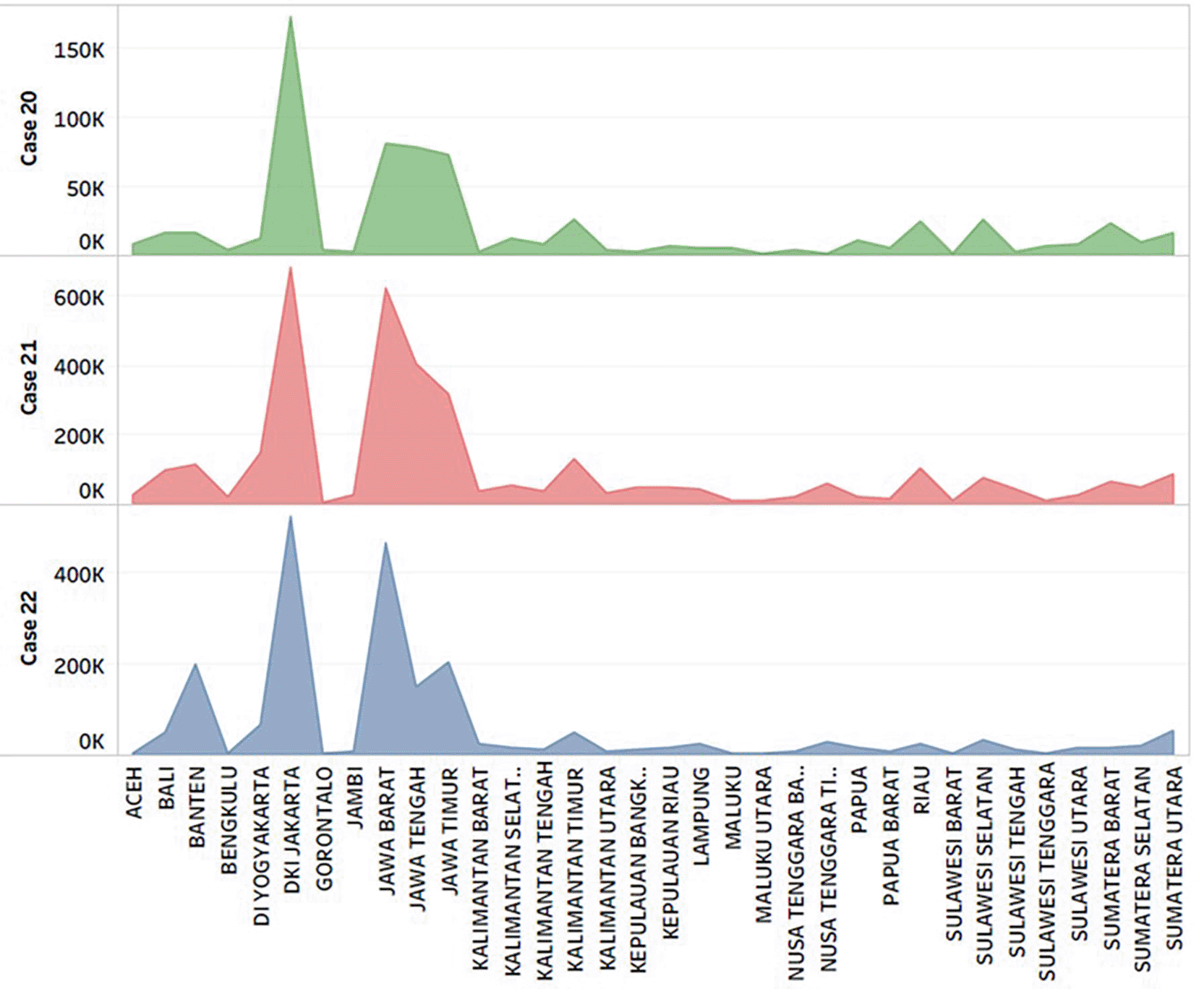
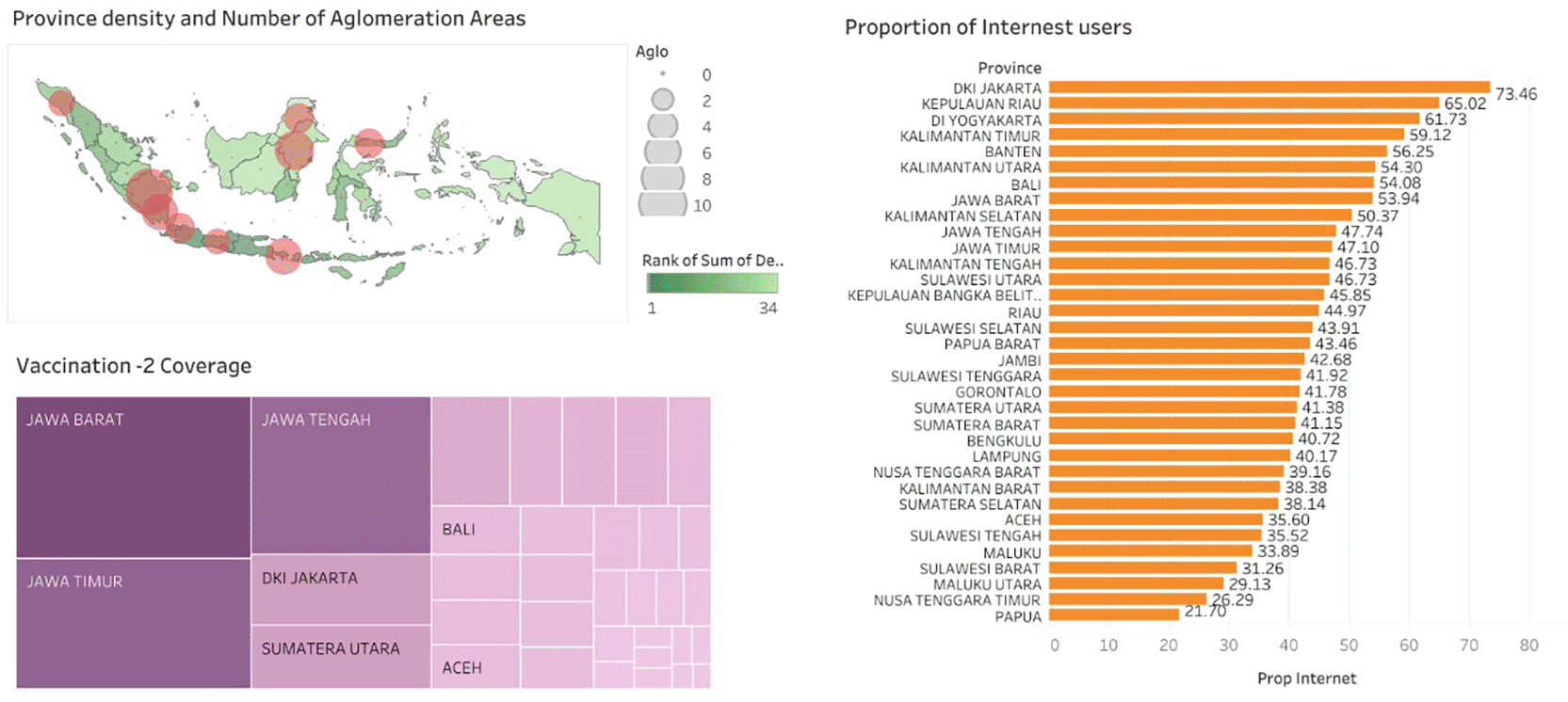
DKI Jakarta, Jawa Barat, Jawa Tengah, Jawa Timur, DI Yogyakarta, and Banten Provinces which are located in Jawa Island are province with highest density of population in Indonesia. In term of vaccination coverage, Jawa Barat, Jawa Timur, Jawa Tengah, DKI Jakarta, and Sumatera Utara are the highest. The highest percentage of internet users are in DKI Jakarta and Riau Island Province, while the lowest are in Papua and Nusa Tenggara Timur ( Figure 2).
Moran test found that in 2020 to 2022, there was autocorrelation among areas based on COVID-19 cases. It means that COVID-19 does not occur randomly but interrelated between one area to its neighbors ( Table 2). Since there is autocorrelation, the hotspot of COVID-19 can be determined further using Moran’s scatter plot ( Figure 3).
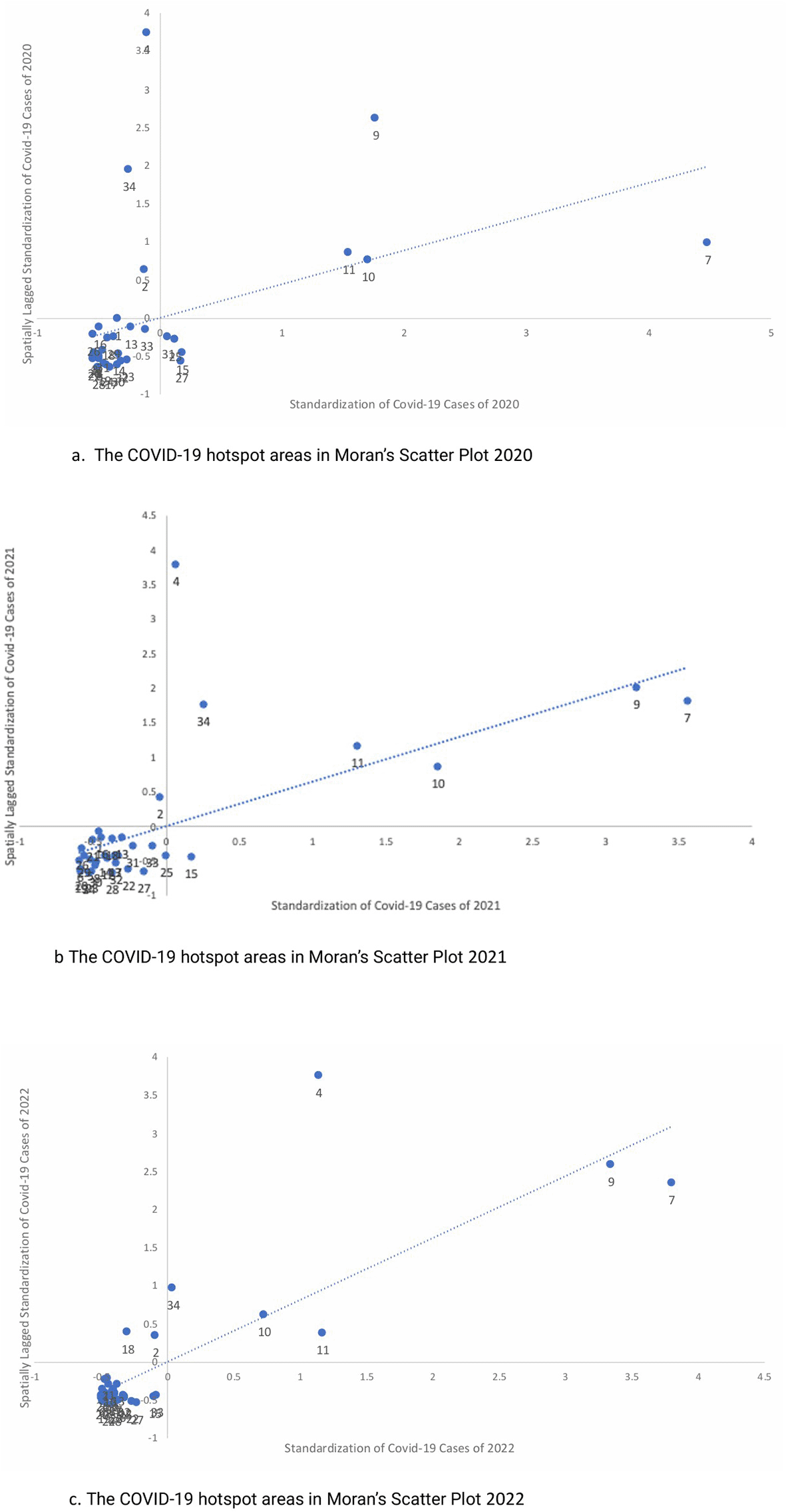
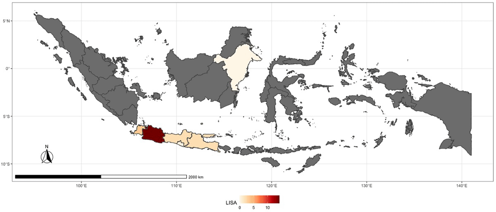
Over the pandemic, certain provinces consistently emerged as COVID-19 hotspots. Notably, DKI Jakarta, West Java, Central Java, and East Java were identified as hotspots across all three years of observation ( Table 3). The hotspot provinces in 2022 are Banten, DKI Jakarta, Jawa Barat, Jawa Tengah, Jawa Timur, and DI Yogyakarta ( Figure 4).
Before conducting the GWR test, all the assumption tests should be fulfilled using classic linear regression. The first assumption test found that the residuals did not distribute under the normal distribution curve ( Table 4). Hence, the researcher did data transformation using natural logarithm transformation method. Afterwards, we did the second assumption test and found that all assumptions have fulfilled ( Table 5).
Assumption test result toward transformed data showed that the residual of COVID-19 cases already distributed under the normal distribution curve, independent, homogeneous, and there was no multicollinearity among all variables ( Table 5). Thus, further analysis could be run to identify risk factors in each area.
The dependent variable in this study is the total number of cases from 2020 to 2022. GWR analysis was done to identify the risk factors. It began with determining bandwidth value by using Kernel Gaussian and Kernal Bi-Square method. These two kinds of bandwidth will be compared in terms of their contribution to the model performance created. The model performance will be seen by comparing the AIC and R2 and Adj-R2 values ( Table 6).
| Component | Regression model | Kernel Gaussian | Kernel Bi-square |
|---|---|---|---|
| AIC | 47.3533 | 38.8130 | 35.9460 |
| R2 | 0.6463 | 0.6680 | 0.7172 |
| Adj - R2 | 0.5975 | 0.5922 | 0.5982 |
Table 6 clearly shows that GWR model with Kernel Bi-square had a better model performance due to the smaller AIC value and the higher R2 and Adj-R2 value. Thus, risk factors modeling with GWR analysis employed Kernel Bi-square bandwidth. The COVID-19 risk factors model of each province is presented in Table 7.
The modeling results show that only variable of proportion of internet users consistently has a positive and statistically significant relationship with COVID-19 cases in all provinces, while other variables do not have a significant relationship with total cases ( Table 7). It is known from the GWR model that areas with a high proportion of internet users are an indication that these regions have high cumulative cases of COVID-19.
The statistically significant Moran index value proves that there is autocorrelation between provinces based on COVID-19 cases. This illustrates that COVID-19 cases in a province does not occur randomly, but have a relationship with COVID-19 cases in neighboring areas.23 This is in line with the theory states that attribute values in an area will tend to be the same as areas that are closer than those farther away which is accordance with the basic concept of geography (Tobler’s Law 1) which states everything is related to everything else, but near things are more related than distant thing.18,24,25
The number of COVID-19 hotspot provinces in Indonesia in 2020 was originally only four4 on Jawa, but in 2021 along with the increasing of COVID-19 cases in the community, the hotspot area became six6 provinces up to 2022. Based on the map in Figure 4, the hotspot area is clustered on Jawa, which means that Jawa Island is a COVID-19 hotspot in Indonesia. This finding is consistent with previous research in Indonesia.23 Jawa Island has a higher population density than other regions in Indonesia ( Figure 2) and also has many agglomeration areas that are centers of economic activity. As such, population mobility in the region will tend to be higher than in other provinces across Indonesia.23,26 The more densely populated and the more mobile the population in an area, the higher the risk of COVID-19 transmission as seen and proved in this study. It applies not only to the transmission of COVID-19, but also to other infectious diseases with a similar transmission mode.27
The only risk factor that consistently had a statistically significant association with COVID-19 across all provinces in Indonesia was the number of internet users ( Table 7). The enactment of mobility restriction policies in all regions particularly in agglomeration areas (which almost all urban areas) has led most citizens to do work and school activities from home and some also use the internet to spend time at home. This finding is consistent with several studies conducted in other countries.28–31 In Indonesia, the distribution of internet is not equal across Indonesia, there is still a gap between rural and urban area, between provinces and even within a province. However, generally, internet is more accessible in urban/city compared to rural areas. Unfortunately, the data cannot represent rural and urban since it was a cumulative number of provinces in which there are urban and rural areas within. Basically, internet can be a strong means for the community to get the correct information but instead it could be a risk to the public health due to misinformation.32
The data can no represent urban and rural area in Indonesia. For information, there are still gaps between areas in Indonesia regarding social characteristic, internet facility, health facility including COVID-19 test equipment which resulted bias of cases due to unreported and undetected cases. The level of province may not represent all conditions in one province due to the variation of areas within a province. This study also did not measure the level of compliance of the population with the movement restriction policy, mask wearing, and hand washing due to data limitations. We assume that in agglomeration area, the population have higher mobilization level.
COVID-19 distribution was most concentrated in Pulau Jawa (Jawa Island) particularly in DKI Jakarta, Jawa Barat, Jawa Tengah, Banten, and Jawa Timur. Geographic weighted regression analysis showed that the distribution of COVID-19 in a province does not occur randomly but has a relationship with COVID-19 cases in the neighboring areas. The hotspot area forms a dense cluster on Jawa Island, meaning that the Jawa Island is a COVID-19 hotspot in Indonesia. Jawa has the highest population density in Indonesia, as well as an agglomeration of economic activities center. The risk factor that is statistically significant consistent with COVID-19 across all provinces in Indonesia is the proportion of internet users.
The study results are very useful to serve as lessons learned in responding to events similar to the COVID-10 pandemic. Indonesia, a vast archipelago, is a unique region that also requires unique or region-specific actions. With the knowledge that the hotspots of the COVID-19 pandemic in Indonesia are areas located on the Jawa Island, if there is an infectious disease outbreak or on a large scale, such as pandemic, then the Jawa Island must be a priority area that must first be addressed and protected. This may be related to its areas which are mostly with higher population density and are the centre of the economy (agglomeration) activities which has an impact on the high level of community activity and mobility. The restricted movement among the community inevitably makes people adapt, especially in terms of technology utilization. The community can quickly shift to be more technology-friendly although this has not occurred evenly throughout Indonesia due to socio-economic disparities in many parts of Indonesia. However, this shifting can provide an opportunity for the government to utilise technology for interventions. To that, the government should improve the infrastructure especially related to the internet provision and other technologies or tools without any doubt since the community in fact are able to adapt.
During the COVID-19 pandemic, the Government of Indonesia developed a publicly accessible web-based dashboard to monitor confirmed cases at both the provincial and district levels. This platform, which provides real-time data on case numbers disaggregated by province, is freely available to the general public (https://covid19.go.id/ which later integrated into https://infeksiemerging.kemkes.go.id/dashboard/covid-19). Leveraging the availability of these spatially referenced data, the research team initiated a study proposal employing spatial analysis techniques to explore the geographical distribution and determinants of COVID-19. The proposal was submitted on June 29, 2022, to the Research Ethics Committee of the Faculty of Public Health, Universitas Indonesia, through an online submission system (https://kajietik.fkm.ui.ac.id). The committee, chaired by Prof. Dr. Ratna Djuwita, MPH, with Prof. Dr. L. Meily Kurniawidjaja, M. Sc, Sp.OK serving as secretary, granted ethical clearance for the study on August 25, 2022. The approval remains valid until August 25, 2023 with letter number is No. Ket-532/UN2.F10.D11/PPM.00.02/2022.
This study was using secondary data which taken from various sources, thus there is no informed consent needed for this study.
| Views | Downloads | |
|---|---|---|
| F1000Research | - | - |
|
PubMed Central
Data from PMC are received and updated monthly.
|
- | - |
Provide sufficient details of any financial or non-financial competing interests to enable users to assess whether your comments might lead a reasonable person to question your impartiality. Consider the following examples, but note that this is not an exhaustive list:
Sign up for content alerts and receive a weekly or monthly email with all newly published articles
Already registered? Sign in
The email address should be the one you originally registered with F1000.
You registered with F1000 via Google, so we cannot reset your password.
To sign in, please click here.
If you still need help with your Google account password, please click here.
You registered with F1000 via Facebook, so we cannot reset your password.
To sign in, please click here.
If you still need help with your Facebook account password, please click here.
If your email address is registered with us, we will email you instructions to reset your password.
If you think you should have received this email but it has not arrived, please check your spam filters and/or contact for further assistance.
Comments on this article Comments (0)