Keywords
Adaptation, climate change, remote sensing, sea level rise
This article is included in the Climate gateway.
Adaptation, climate change, remote sensing, sea level rise
One of the contributing factors to the current global climate change is the rise in sea level. Indeed, the increase in greenhouse gas concentrations in the atmosphere since the mid- 19th century has led to an energy imbalance of the earth system, typified by an increased influx of radiation compared to infrared energy reflected into space. This energy imbalance led to the warming of the climate system-the oceans, atmosphere, and cryosphere-which directly affects the rise in global average sea level (von Schuckmann et al., 2020). According to the latest data from the World Meteorological Organization (2025), the rate of global sea level rise has significantly risen, from about 2.1 mm per year for the periods 1993–2002 to 4.7 mm per year for the period 2015–2024. In general, two main mechanisms cause sea level rise, namely the thermal expansion of seawater due to increased temperatures and the melting of land ice from ice sheets and glaciers. The most considerable contribution comes from the storage of heat energy in the ocean, where more than 90% of the excess energy caused by global warming is absorbed into the ocean water column. In addition, the melting of ice sheets in Greenland, Antarctica, and mountain glaciers also contributes significantly to this rise (Meyssignac et al., 2019).
The trend of global mean sea level (GMSL) rise, as detected through observational records, shows an increase of 0.20 meters since the early 20th century. Satellite altimetry measurements from 1993 to the present indicate an acceleration in sea level rise, at a rate higher than previous tide gauge records (WCRP Global Sea Level Budget Group, 2018). This fact confirms that global warming is not only continuing but also accelerating. In addition to global trends, the impact of sea level rise varies significantly across different regions. In addition to global trends, the impact of sea level rise varies greatly in different regions such as large river deltas and low-lying islands, which are more vulnerable due to a combination of sea level rise, land subsidence, and human activity along the coast. Therefore, monitoring of shoreline response and sea level variation are seen as two crucial and interrelated impacts, both of which are direct responses to large-scale climate forcing (Graffin et al., 2025). Furthermore, Mao et al. (2025) indicate that the forecast of shoreline evolution in response to sea level rise and wave climate change is also a priority for sustainable management of the coasts. Therefore, monitoring sea level with accuracy and continuity is not only a key factor in understanding global climate dynamics but also a strategic leverage to support adaptation strategies at coastlines. For this reason, policymakers need information on trends, acceleration, and spatial variation of sea level rise to devise effective mitigation and adaptation at both the local and global levels.
Predicting shoreline evolution in response to sea level rise and wave climate change is also critical for sustainable coastal management (Mao et al., 2025). Thus, accurate and continuous sea level monitoring is essential, not only to understand global climate dynamics but also to support coastal adaptation strategies. Information on trends, acceleration, and spatial variations in sea level rise is crucial for policymakers to develop effective mitigation and adaptation measures at both local and global levels.
Remote sensing technology has enabled breakthroughs in understanding dynamic processes on the planet, such as those in the oceans and atmosphere. Remote sensing is an observation technique that uses sensors installed on board satellites and aircraft to gather information about the Earth’s surface without direct physical contact. This technique promotes the study of Earth’s surface over vast spatial domains and temporal resolutions, thereby allowing the observation of natural processes over the entire lifetime of Earth (Cazenave & Moreira, 2022). In marine research, remote sensing uses various tools, including radar altimeters, satellite gravimeters, optical altimeters, and laser altimeters. Radar altimeters launched during the TOPEX/Poseidon mission, which began in 1993, were designed to detect tiny changes on the sea surface and provide an accuracy of up to 4 cm per day (Ballarotta et al., 2019). On the other hand, satellite gravimetry, such as the Gravity Recovery and Climate Experiment (GRACE) mission, provides information on the distribution of seawater masses resulting from climate change.
The primary advantage of remote sensing lies in its ability to produce global, long-term data that provide inherent and contextual information for sea-level observations. This technique makes it easier to gather information about areas that are either difficult to access or dangerous, serving as the cornerstone of informed decision-making. In addition, remote sensing is the preferred strategy for environmental observation, especially regarding the examination of land use and land cover variations (Jensen, 2014) and the observation of the impact of climate change, primarily based on the measurements of sea-level increase and the distribution of various greenhouse gases (Masria A., 2024). Some studies have used not only one type of data but also combined satellite altitude measurements and LiDAR data to chart coastal elevation and assess the risk of sea-level rise (Bogning et al., 2018; Chust et al., 2008; Rizzo et al., 2025). Altimetry data have enabled sea-level observations for three decades, and the use of optical and LiDAR provides information for coastal observations. Therefore, this technique serves not only as an instrument for scientific study but also as the cornerstone for making environmental policy and adapting to climate change, as shown using the European Union’s Copernicus program (Melet et al., 2021).
The application of remote sensing technology to sea level rise has been considered a breakthrough in climate research. Satellite altimetry enabled the measurement of sea surface levels on a global and daily basis from 1993, hence delivering very accurate and consistent long-term records. Long-term trends and acceleration in sea level rise can be detected using this data, while natural climate variability and changes resulting from anthropogenic activities are distinguishable (Nerem et al., 2018). A number of remote sensing technologies have an important role in understanding sea level rise and coastal vulnerability. Detecting changes in seawater mass due to melting of land ice and variation in land water storage is done by GRACE gravimetry data, while changes in coastal land deformation are observed by SAR. Altimetry and LiDAR support flood modelling and coastal spatial planning with high-precision elevation data, resulting in more accurate projections of seawater intrusion and land loss (Cazenave & Le Cozannet, 2013). Synergy between technologies, including ICES at laser altimetry and tidal data validation, reduces uncertainty and produces more reliable information.
Studies on sea level rise using remote sensing are generally still partial, both in terms of region and method, making them difficult to compare due to differences in sensor usage, such as altimetry, gravimetry, and LiDAR. Several remote sensing-based studies highlight only technical aspects or global trends, while systematic studies on the effectiveness and accuracy of technology remain limited, as explained in Legeais et al., (2021). The other studies show that sea level rise studies focus more on identifying global trends than evaluating the accuracy of methods, as demonstrated by Dash et al. (2025)‘s analysis of sea level anomalies in ocean parameters, and Hamlington et al. (2023) on the acceleration of sea level rise in the last three decades.
The study by Jia et al. (2022) compiled multi-satellite altimetry data to calculate sea level changes technically without discussing field validation in depth. The accuracy and robustness of Global Mean Sea Level (GMSL) observations are a considerable methodological concern that needs to be overcome (Guérou et al., 2023). However, the search for the most reliable technologies for continuous observation and validation of climate modelling requires an extensive survey of the literature to assess research trends, capabilities, and limitations. In an attempt to merge and evaluate advancements, the study appears to focus on the use of the Systematic Literature Review (SLR) method for two primary purposes. Firstly, there is interest in exploring the use of remote sensing technology to detect and monitor sea level rise. In essence, the study seeks to assess which of the available technologies for sea level increase observation are most pertinent and reliable for the observation process.
This leads to the development of two major research inquiries that guide the study and are addressed to enhance research and support the development of correlated adaptive and mitigation measures for sea levels. These research inquiries are as follows: (1) What remote sensing method can be most applicable for sea-level rise observation? and (2) How do the accuracy levels of the various observation methods differ for comparison consideration?
Research on the use of remote sensing satellites to monitor sea level rise due to climate change was reviewed by combining various literature from geography and environmental science, thereby providing an accurate understanding of the role of remote sensing technology in monitoring and evaluating environmental conditions. This method was carried out systematically with reference to the PRISMA protocol (Moher et al., 2009), as well as methodological updates refined in PRISMA 2020 (Page et al., 2021).
To ensure a comprehensive and high-quality literature synthesis, this study utilized two prominent scholarly databases: Scopus and Web of Science (WoS). Scopus was selected for its extensive coverage of social and environmental sciences (Shaffril et al., 2018), while WoS provided access to highly reputable, peer-reviewed journals across multidisciplinary fields. The search was conducted in August 2025, focusing on the most recent decade (2016–2025) to capture advancements in satellite-based monitoring and the latest generation of remote sensing technologies. The following search string was employed to identify relevant literature:
((“Remote Sensing” OR Satellite) AND (Monitoring) AND (“Sea Level Rise” OR “Shoreline Changes”))
The Boolean operator “OR” was applied to “Sea Level Rise” and “Shoreline Changes” to broaden the scope, ensuring the inclusion of studies discussing either phenomenon or their interrelationship. Initial searches yielded 821 records from Scopus and 945 records from WoS.
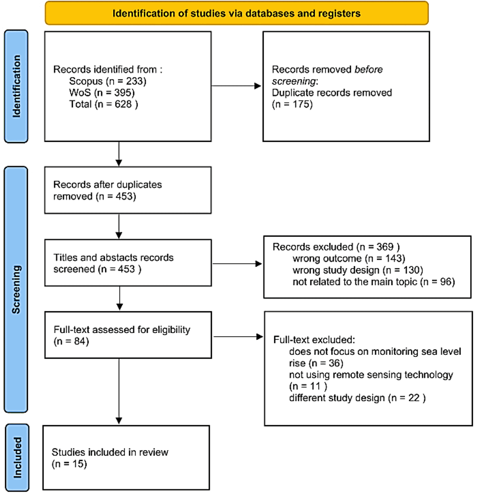
To maintain academic rigor, the retrieved documents were screened based on predefined inclusion and exclusion criteria, as detailed in Table 1. Only peer-reviewed journal articles published in English and available via Open Access were retained. Following the initial screening, the pool was refined to 233 articles from Scopus and 395 from WoS, resulting in a final total of 628 articles for eligibility assessment.
Before screening, to avoid duplication of similar articles in one database with another, articles suspected of being duplicates were resolved using the Rayyan online platform. The results revealed that 175 articles in the Scopus database had a similarity of over 95% to articles in the WoS database, resulting in a total of 453 articles entering the screening stage. The first screening stage examined the title and abstract of each article. Articles irrelevant to the research topic and objectives were then ‘excluded’. Articles that clearly had a scope in accordance with the research questions that had been formulated were ‘included’. In contrast, information lacking detail in the title and abstract was included in the ‘maybe’ option for further full-text screening. This process was carried out collaboratively as a team to maintain consistency and validity, resulting in more accurate and accountable decisions. A total of 369 articles were excluded, consisting of 143 articles with wrong outcomes or research results that did not match the focus of the study, 130 articles with study designs that were not relevant to the required research design, and 96 other articles that were not included because their topics were not directly related to the main issues discussed in this study, leaving 84 articles included for full-text screening.
The second screening stage involved selecting articles by reading the full contents of each selected article in detail. The authors divided the tasks for this stage, agreeing on specific provisions that specifically address the use of remote sensing in monitoring sea level change. Of the 84 articles, 15 met the eligibility criteria based on the research purposes ( Figure 1).
Quality assessment was conducted on 15 articles that had passed the screening stage based on the PRISMA protocol. This process involved systematic evaluation using the Joanna Briggs Institute (JBI) Critical Appraisal Checklist for cohort studies. Although this tool is widely used in medical and social research, several types of checklist tools, including one for cohort studies, are relevant for quantitative, observational, and temporal research, with some adjustments to the questions. This step evaluates the risk of bias in the primary studies by asking questions about each sample article/study related to exposure assessment, measurement of exposure and outcome variables, control of confounding factors, and appropriate statistical analysis. Answers are determined by selecting one option (yes, no, unclear, or not applicable). Based on the cumulative score for each question, all article samples can be categorized as meeting the quality standards for inclusion in the research.
During the data extraction stage, document characteristics, including study information, study area, study design, and research limitations, were identified. This data was used to classify the types of remote sensing widely used globally to monitor sea level rise, based on a sample of articles that had passed the eligibility criteria. Details of the data extracted from the selected studies are presented in Table 2.
The number of publications, prominent journals, and authors in sea level rise research has increased since 2017. Early research in 2017 focused on regional sea level rise. The use of advanced methods, such as GNSS reflectometry, virtual tide gauge data, and analyses of vertical land motion, represented a major expansion during the 2018–2019 period. Research on sea level rise was improved in 2020 by increasing the application of remote sensing methods. This field peaked in 2021 with the highest number of research articles covering a wide range of topics, including regional sea level dynamics, decadal climate variability, and contributions from Copernicus satellites. The research remained consistent from 2023 to 2024, with a focus on satellite-based monitoring to support adaptation policy and long-term trend assessments in the North Atlantic. The most recent study, which was released in 2025, underscores the importance of regional dynamics by discovering that shifts in water balance have reduced sea level rise in the Eastern Mediterranean. Research from 2017 to 2025 shows an increasing trend overall, with 2021 marking the peak of methodological innovation and scientific output in SLR impact studies. Key information regarding the included studies is summarized in Table 3.
| Title and source (DOI) | Study region/scale | Sea-level component | Sensors/Data used | Time span | Validation data |
|---|---|---|---|---|---|
| Virtual Tide Gauges for Predicting Relative Sea Level Rise (Hawkins et al., 2019) | Coastal site-based | Relative sea level, geocentric sea level, Vision language modeling (VLM) | Tide gauges (TG), GPS, and satellite radar altimetry (SRA) | TG: decadal to secular time scales SRA: 1992-present GPS: late 20th century onward | GPS and satellite altimetry |
| The Eastern Mediterranean Sea mean sea level decadal slowdown: the effects of the water budget (Borile et al., 2025) | Regional basin scale and sub regional | Mean Sea Level (MSL) trend | Tide gauges, satellite radar altimetry, GPS (VLM-MIDAS), reanalyses datasets for the past 30 years (1993–2022) | 1998–2017 | Tide gauges, GPS, satellite altimetry |
| Underlying drivers of the decade-long fluctuation in the global mean sea-level rise (Cha et al., 2021) | Global | Global mean sea-level (GMSL) trend | Satellite Altimetry, Argo Floats, Reanalysis Ocean Product (IK, EN4, NOAA, MERRA and MERRA-2), GRACE | Satellite altimetry: 1993–2018 Steric Component: 1993–217 (IK available until 2012); MERRA and MERRA-2 (before 2002–2017) Argo floats: 2005–2017 GRACE: 2002–2027 | Satellite Altimetry, Argo Floats, Reanalysis Ocean Product, GRACE, ice sheet and glacier datasets, with trends extracted using EEMD |
| The sea-level budget along the Northwest Atlantic coast: GIA, mass changes, and large-scale ocean dynamics (Frederikse et al., 2017) | Regional/coastal | Relative sea level | Tide gauges, GPS, GRACE, Satellite altimetry (AVISO), Reanalysis atmosphere | 1965–2014 (50 years) | Tide gauges and GPS observations of relative sea level and vertical land motion are compared to the cumulative effect of GIA, present-day mass redistribution, and ocean dynamics over 50 year period (1965–2014) |
| Spatial Variability of Relative Sea-Level Rise in Tianjin, China: Insight From InSAR, GPS, and Tide-Gauge Observations (Tang et al., 2021) | Regional/coastal | Relative sea level | InSAR, CGPS, tide gauges | InSAR: January 2017–April 2019 | InSAR was combined with CGPS in order to tie the InSAR relative rates to the absolute CGPS geodetic reference frame |
| Seasonal Patterns, Inter-Annual Variability, and Long-Term Trends of Mean Sea Level Along the Western Iberian Coast and the North Atlantic Islands (Biguino et al., 2024) | Regional coastal and island scale | Mean sea level | Tide gauges, satellite altimetry (AVISO), Auxiliary data (NAO, Winter NAO, EA, WeMOI, SOI, AMO), ERA5 wind data, ocean temperature anomalies (0–700 m) | TG: minimum 20 years (1943–2022, 1973–2022, 1993–2022) SA: 1993–2022 ERA5: 1940–2022 Ocean temperature anomalies: 1955–2022 | TG–altimetry comparison |
| Sea-level rise and vertical land motion on the Islands of Oahu and Hawaii, Hawaii (Yang & Francis, 2019) | Island scale | Relative sea level, absolute sea level, steric sea level, ocean mass component, VLM | Tide gauges, GNSS, satellite altimetry, GRACE, Temperature and Salinity (EN4.2.1) | TG: 1948–2017 SA: 1993–2017 GRACE: 2002–2017 Temperature and salinity: 1947–2017 | All sea-level datasets were corrected for seasonal, instrumental, and geophysical effect |
| Satellite monitoring for coastal dynamic adaptation policy pathways (Hamlington et al., 2023) | Global | GMSL, perubahan regional, dan proses contributor (es, sterodinamik, VLM) | Altimetri, Gravimetri, SAR (Sentinel-1, NISAR), LiDAR (ICESat-2) | 1992-present | Pasut in-situ, GPS station, and impact indicators such as flood extent |
| Integrated Analysis of the Combined Risk of Ground Subsidence, Sea Level Rise, and Natural Hazards in Coastal and the Delta River Regions (Zhao et al., 2021) | Yangtze River Delta (YRD), the Pearl River Delta (PRD), Shanghai | Regional sea level rise, land subsidence, and flood risk | SAR (Sentinel-1, CSK, ENVISAT, Radarsat-2), Optic Sentinel-2, Altimetri | 1993–2020 | Data levelling, GPS (PULK station), geotechnical model, and TanDEM-X DEM |
| Validation of Copernicus Sea Level Altimetry Products in the Baltic Sea and Estonian Lakes (Liibusk et al., 2020) | Coastal regions of the Baltic Sea | Sea Surface Height (SSH) and Sea Level Anomaly (SLA) | Sentinel-3 SRAL (Level 2 & Level 3), CMEMS product, NEMO reanalysis model | Level 3 = 2014–2017 Level 2 = 2019 | Shipborne GNSS, geoid model (EST-GEOID2017), 21 tide gauges, and pressure buoys |
| Observational Requirements for Long-Term Monitoring of the Global Mean Sea Level and Its Components Over the Altimetry Era (Cazenave et al., 2019) | Global | GMSL, steric component, and mass components (ice/land water) | Satellite altimetry (TOPEX-Jason), GRACE/GRACE-FO gravimetry, Argo floats | Altimetry = 1993–2019 Argo/GRACE = 2005-present | Sea level budget closure assessments |
| Evaluation and improvement of coastal GNSS reflectometry sea level variations from existing GNSS stations in Taiwan (Lee et al., 2019) | Taiwan | Coastal Sea Level Heights (SLHs) and absolute sea level trends | GNSS Signal to noise ratio (SNR) data from existing stations (Kaohsiung, Suao, TaiCOAST) | Kaohsiung (2006–2011) Suao and TaiCOAST (2015) | Co-located/nearby traditional tide gauges and multimission satellite altimetry |
| Current observed global mean sea level rise and acceleration estimated from satellite altimetry and the associated measurement uncertainty (Guérou et al., 2023) | Global | GMSL anomalies, trends, and acceleration | Reprocessed L2P 21 data (TOPEX/Poseidon, Jason-1, −2, −3) | January 1993 – December 2021 | Sea level solutions form NASA GSFC, NOAA STAR, University Colorado and CSIRO |
| Copernicus Sea Level Space Observations: A Basis for Assessing Mitigation and Developing Adaptation Strategies to Sea Level Rise (Legeais et al., 2021) | Global | GMSL and regional trends | Satellite altimeters (TOPEX/Poseidon, Jason series, Sentinel) CMEMS & C3S products | 1993–2021 | Tide gauges, Argo profiles (steric height), and crossover comparisons |
| GOM20: A Stable Geodetic Reference Frame for Subsidence, Faulting, and Sea-Level Rise Studies along the Coast of the Gulf of Mexico (Wang et al., 2020) | Coastal and inland areas around the Gulf of Mexico | Relative Sea-Level (RSL) trends and absolute rise | 55 GNSS stations (GOM20), 30 tide gauge stations, IGS14 | GNSS (average 13,5 years) Tide gauges (average ~ 5 decades) | Closely-spaced tide gauge and GNSS pairs, and comparison of NAD83 and NA12 frames |
Research on sea level rise highlights the importance of robust cross-border collaboration, with studies tailored to the unique geographical and environmental challenges of each region. China is a leading contributor, conducting research on the spatial variability of relative sea level rise in Tianjin and spearheading the large-scale Dragon IV project, which applies Earth Observation technologies to monitor coastal zones in China and the Saint Petersburg region of Russia (Tang et al., 2021; Wang et al., 2020). The United States has also played a central role through long-term investigations along the Northwest Atlantic and Hawaiian coasts, as well as joint research with Mexico in the Gulf of Mexico that integrates GNSS, tide gauges, satellite altimetry, and geodetic models to assess interactions between sea level rise and vertical land movement (Wang et al., 2020). In Europe, Portugal has a well-developed understanding of seasonal, interannual, and multidecadal sea level variability along the Iberian coast and North Atlantic islands (Biguino et al., 2024). In contrast, Estonia has focused on validating satellite altimetry products in the Baltic Sea (Liibusk et al., 2020). Taiwan has strengthened regional monitoring through GNSS reflectometry applications in major ports, and Russia has contributed via coastal monitoring collaborations with China (Lee et al., 2019). France, through the Copernicus program, has played a crucial role in producing global estimates of sea level rise and developing indicators to inform climate change mitigation and adaptation strategies (Legeais et al., 2021). China and the United States are the most active contributors overall. Portugal, Estonia, Taiwan, Russia, and Mexico, on the other hand, only contribute through studies on their specific regions.
The fifteen reviewed studies collectively demonstrate the diverse applications of remote sensing and geodetic methods for monitoring sea level rise across global, regional, and local scales. At the global scale, satellite altimetry has provided the foundation of sea level observation. Reprocessed datasets from TOPEX/Poseidon, Jason-1/2/3, and Sentinel missions, often combined with GRACE and GRACE-FO gravimetry, consistently report a global mean sea level (GMSL) rise of approximately 3.1–3.4 mm/yr with acceleration ranging from 0.08 to 0.12 mm/yr2 (Legeais et al., 2021; Guérou et al., 2023; Cazenave et al., 2019; Hamlington et al., 2023). The methodological frameworks and specific limitations of each study are systematically detailed in Table 4.
Limitation codes: [SR] Short Record, [CC] Coastal Contamination, [VLM] VLM Issues, [SG] Sparse Coverage, [LR] Low Resolution, [MC] Mission Continuity, [UA] Uncertainty, [MD] Model Dependency.
| Data used | Focus of analysis & main findings | Spatial scale | Temporal coverage | Limitations | Validation strategy | Author |
|---|---|---|---|---|---|---|
| Tide Gauge (TG) | Tide gauges serve as the primary long-term reference for measuring Relative Sea Level (RSL). When combined with GPS or altimetry, they enhance Vertical Land Motion (VLM) and RSL accuracy. The general sea-level rise trend aligns with satellite data, showing regional variability linked to ocean dynamics and the Atlantic Multidecadal Oscillation (AMO). | Coastal stations; Global network (PSMSL); Dense: Europe, N. America; Sparse: Africa, S. America. | 1998–2017 (contemporary); Longer records available (70+ yrs); ≥3 years minimum; Error < 3.0 mm/yr | [SR] The 20-year interval enhances uncertainty due to interannual/decadal variability (AMO, ENSO); trade-offs between contemporary relevancy and trend stability. [SG] Limited distribution in specific coastal areas (Africa: 71 stations; S. America: 22 vs Europe: 241). [VLM] High sensitivity to local subsidence; requires GPS within ~20 km range for precise separation of RSL components. [UA] Monthly data gaps >10 days/month flagged; dependence on long-term high-quality records makes global spatial analysis challenging. | IB/DAC atmospheric correction (ERA-Interim); GPS co-location for VLM; Z-score comparison (|Z| < 2 agreement); Cross-validation with altimetry. | (Biguino et al., 2024; Frederikse et al., 2017; Hawkins et al., 2019; Lee et al., 2019; Yang & Francis, 2019) |
| Satellite Altimetry (TOPEX, Jason, Sentinel, DUACS, SRA) | Satellite altimetry enables global monitoring of GMSL with millimeter-level accuracy (~3.1–3.3 mm/year). It detects long-term trends and accelerations, supports coastal adaptation policymaking, and provides valuable input for spatial and oceanographic analyses. | Global ocean; 66°N-66°S coverage; ~300 m along-track resolution; Gridded products: 0.25°. | 1993-present; Trend: 3.1–3.3 mm/yr; ≥12 monthly observations; Error < 1.5 mm/yr; Temporal inconsistencies between missions. | [CC] False ground reflections within 10—20 km of shore; points within 20 km removed or altered. [LR] Coarse spatial resolution at high latitudes (>66°); gridded products reduce the visibility of small-scale features. [MC] Temporal inconsistencies between missions require careful crosscalibration; systematic jumps up to 1 cm observed (Black Sea example). [UA] Atmospheric disruptions, wave effects, and orbit determination errors reduce the detection of small regional climate signals. | Tide gauge comparison (coastal); Cross-calibration between missions; DAC correction (IB + barotropic); Homogeneous reference field (C3S products). | (Borile et al., 2025; Cazenave et al., 2019; Cha et al., 2021; Guérou et al., 2023; Hamlington et al., 2023; Legeais et al., 2021; Liibusk et al., 2020; Zhao et al., 2021) |
| GPS/GNSS (including GNSS-R, VLM data) | GNSS data are used to separate Vertical Land Motion (VLM) from RSL and correct tide gauge records. GNSS-R provides high potential for coastal sea-level monitoring, while GOM20 offers a stable geodetic reference frame (~0.5 mm/year) for long-term trend detection. | Coastal/inland stations; Dense: US (4,756), Europe (2,847); Sparse: S. America (287), Africa (683); GNSS-R: coastal potential. | ≥2 years recording; ≥75% uptime (1998–2017); ≥10% recording ratio; <2.0 mm/yr velocity uncertainty; MIDAS removes discontinuities. | [SG] Low station density in some regions. [LR] Subsidence varies at sub-km scales in deltas; GPS stations (point measurements) miss spatial variability. [VLM] MIDAS assumes linear trends, which are invalid for co-seismic events (e.g., Indonesia and Japan) and anthropogenic nonlinear processes and can introduce errors of up to 0.4 mm/yr when these nonlinearities are unaccounted for. [UA] GNSS-R sensitive to environmental reflections (ships, vegetation); frame 0.3 mm/yr in the horizontal directions and 0.5 mm/yr in the vertical direction (GOM20); requires offset adjustments for equipment changes. | Joint inversion and comparative analysis of SRA, GPS, and TG data; Spatial and “leave-one-dataset-out” cross-validation; Outlier filtering for extreme VLM rates (>30 mm/yr); Offset adjustment for equipment changes and seismic events; Hector software implementation for robust trend estimation. | (Frederikse et al., 2017; Hawkins et al., 2019; Lee et al., 2019; Wang et al., 2020; Yang & Francis, 2019) |
| GRACE/GRACE-FO (Satellite Gravimetry) | GRACE measures global and regional mass change, closing the sea-level budget. GMSL fluctuations are linked to variations in ocean heat content and land water storage. | Near-global satellite altimetry (±66°–±82°); 0.25° gridded products; ~300 km gravimetric resolution; Sparse coastal tide gauge networks in Africa and South America. | 2002-June 2017 (GRACE) June 2018-present (GRACE-FO) leading to moderate gap between missions; Monthly basis; Ensemble mean annual time series. | [SR] 20-year record (GRACE) limits multi-decade trends detection; unreliable secular vs decadal separation. [LR] ~ 300 km resolution cannot resolve mass changes at sub-regional level; coastal signals were contaminated by terrestrial leakage. [MD] Separating mass redistributions in the Earth’s interior (GIA) from surface water and ice changes is a major source of uncertainty; Applying different global GIA models yields a difference of approximately 0.2 mm/yr in global mean sea level (GMSL) estimates. [MC] 18-month gap between GRACE/GRACE-FO leading to discontinuity; requires interpolation or model filling. | Sea level budget closure (altimetry + steric + mass); Comparison with hydrological models; Validation against in-situ mass measurements; Multi-solution combined approach. | (Cazenave et al., 2019; Cha et al., 2021; Hamlington et al., 2023; Yang & Francis, 2019) |
| InSAR/DInSAR | InSAR effectively maps land subsidence and spatial RSL variability in coastal and delta regions. Atmospheric correction significantly improves monitoring accuracy to sub-centimeter per year. | Coastal zones, urban areas, deltas Site-specific studies; Swath width: 250 km (Sentinel-1); Pixel resolution: 5–20 m. | Mission-dependent
Sentinel-1: 2014—present; 6—12 day repeat; SBAS and PSInSAR techniques utilize multi-temporal stacking for deformation analysis. | [CC] Processing artifacts in complex coastal topography: layover, shadow, decorrelation in wetlands. [LR] Land cover classification challenges; temporal decorrelation in vegetated areas reduces phase coherence. [UA] Atmospheric delays significant; correction critical for sub-cm accuracy; achieving sub-mm precision technically demanding. [MC] Requires sustained mission continuity; cross-sensor calibration complex; different wavelengths (C-band, X-band) have different sensitivities. | GPS comparison at benchmarks; Leveling survey validation; Cross-validation between ascending/descending; Atmospheric correction verification. | (Tang et al., 2021; Zhao et al., 2021) |
| Ocean & Atmospheric Reanalysis/Dynamics Data | Oceanic and atmospheric reanalysis data explain decadal sea-level variability driven by circulation patterns, ocean heat content, and water cycle dynamics. | Regional to global basins; Typical resolution: 0.25–1°; High resolution (e.g., SAR Altimetry ~300 m) for coastal/lakes; Mediterranean, Atlantic focus in studies. | Reanalysis datasets (e.g., ERA5, 20th Century Reanalysis); Model-dependent periods; Monthly/daily outputs; Multi-decadal hindcasts. | [UA] High uncertainty in coastal zones and complex topography; boundary effects significant. [MD] Model assumptions limit validity: constant Dardanelles outflow, simplified steric effects, parameterized mixing. [LR] Coarse grid (0.25–1°) misses fine-scale circulation features, eddies, fronts; coastal processes are poorly resolved. [MC] Reanalysis version changes introduce discontinuities; ERA-Interim → ERA5 transition requires careful handling. | Comparison with observations (Argo, XBT, moorings, tide gauges); Budget closure analysis; Multi-model ensemble; Sensitivity testing of key parameters. | (Borile et al., 2025; Cha et al., 2021; Frederikse et al., 2017) |
| Argo Float (Temperature & Salinity Profiles) | Argo data help quantify the thermosteric contribution to sea-level rise and close the global sea-level budget. | Open ocean; Global array; Sparse: >60° latitude, marginal seas; Depth: 0–2000 m. | 2000-present Full coverage: 2005+ | [SG] Sparse coverage: high latitude (>60°), Southern Ocean, marginal seas, Mediterranean; float distribution uneven. [CC] Limited coastal representation; floats avoid shelves (<1000 m depth); cannot resolve shelf/estuary dynamics. [MC] Requires crosscalibration using independent observing systems. [SR] Limited pre-2005 for full global thermosteric estimates; early Argo era has data quality issues | Ship-based CTD comparison; Satellite salinity cross-validation; Quality control flags (GDAC); Objective analysis for gridding. | (Cazenave et al., 2019; Cha et al., 2021) |
| Sea Surface Temperature & Salinity (In-situ/Satellite) | Used to isolate the thermosteric component of RSL rise, improving understanding of oceanographic contributions to local sea-level changes. | Surface ocean Global coverage (satellite) | Historical in-situ: 1950s+ | [SR] Historical data limited and variable quality, particularly Southern Ocean; pre-satellite era sparse. [UA] Difficult to separate local thermosteric effects from global trends; aliasing of internal waves, eddies. [CC] Coastal SST contaminated by land thermal emissions; requires quality flags; SSS in river plumes problematic. | Drifter/mooring comparison; Radiosonde matchups; Cross-sensor validation; Buoy calibration/validation. | (Yang & Francis, 2019) |
| Multi-Satellite Data (Sentinel, Jason, GRACE-FO, ICESat-2, etc.) | Integrates multiple satellite observations within the Dynamic Adaptive Policy Pathways (DAPP) framework to support coastal adaptation and risk management. | Coastal adaptation zones; Variable coverage by sensor; Integrated products experimental; | Mission overlap periods essential 2015+ for full constellation; Near-real-time to reprocessed. | [CC] Limited spatial coverage in shallow coastal zones (<10 m depth) across all sensors; integration doesn’t solve fundamental coastal gaps. [UA] Complex error propagation in multi-sensor fusion; uncertainty quantification challenging; correlated errors difficult to separate. [MC] Requires sustained funding for operational multi-mission processing; institutional coordination across agencies. [VLM] Integration assumes consistent VLM estimates across measurement types; tide gauge vs GPS vs InSAR differences. | Cross-sensor consistency checks; Ground truth campaigns; Uncertainty propagation analysis; Bayesian data fusion approaches. | (Hamlington et al., 2023) |
At the regional scale, the integration of altimetry with GNSS, tide gauge, and buoy observations has improved the validation of satellite products and the characterization of spatial variability. Liibusk et al. (2020) validated Sentinel-3 sea level products in the Baltic Sea and inland waters, showing sub-decimeter accuracy in open coastal areas but reduced performance in inland lakes. Yang et al. (2019) combined tide gauges, GNSS, and altimetry to distinguish stable from subsiding islands in Hawaii, while Zhao et al. (2021) applied DInSAR and multi-sensor integration to assess sea-level rise vulnerability in China’s deltas and Saint Petersburg, achieving millimetric accuracy. Wang et al. (2020) constructed a stable Gulf of Mexico geodetic reference frame (GOM20) using long-term GNSS data, which supported more reliable estimates of coastal subsidence and sea-level rise in the region. Several studies at the local scale focused on site-specific monitoring approaches. By estimating sea level shifts at Taiwanese harbors using GNSS-IR and SNR data, Lee et al. (2019) reported centimeter-level accuracy at coastal stations. Other local validations explored how environmental and spatial factors, such as cloud interference, biases in geophysical corrections, and radar altimeter performance close to the coast, affect data reliability. (Liibusk et al., 2020; Hamlington et al., 2023). Figure 2 provides a schematic example of a subsiding coastal system (the Gulf of Mexico) showing how a moderate regional altimetry trend can translate into extreme effective relative sea-level rise when combined with subsidence.
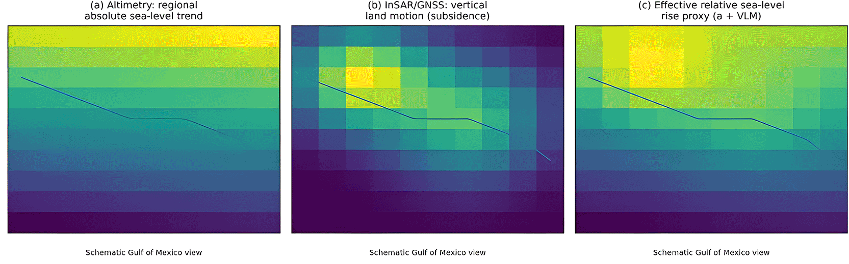
Example region: Gulf of Mexico. (a) Schematic altimetry-based regional sea-level trend (absolute sea level). (b) Schematic InSAR/GNSS-derived subsidence pattern (vertical land motion). (c) Schematic effective relative sea-level rise proxy combining (a) and (b) to highlight hotspots of the greatest locally experienced rise. Note: Panels are conceptual and intended to synthesize the reviewed evidence rather than reproduce a specific dataset.
These studies demonstrate how different monitoring methods complement one another across these scales. While GNSS networks and reference frames facilitate the monitoring of vertical land motion and relative sea level at regional scales, satellite altimetry and gravimetry offer reliable long-term global records.
Sea-level fluctuations have been recorded through a variety of remote sensing methods, with numerous studies focused on different variables. Sea surface height (SSH) and sea level anomaly (SLA) data that have been adjusted for atmospheric effects, tides, and inter-mission biases are typically used in satellite altimetry studies (Cazenave et al., 2019; Legeais et al., 2021; Guérou et al., 2023; Hamlington et al., 2023; Biguino et al., 2024). To explain the observed variations in sea level fluctuation, researchers also use climate indicators such as the North Atlantic Oscillation (NAO), Atlantic Multidecadal Oscillation (AMO), and El Niño Southern Oscillation (ENSO). Gravimetry from GRACE (Yang et al., 2019; Hamlington et al., 2023) provided ocean mass change variables, often combined with steric components from temperature and salinity or Argo floats. GNSS-based studies (Frederikse et al., 2017; Hawkins et al., 2019; Lee et al., 2019; Wang et al., 2020) emphasized vertical land motion (VLM), reference frame stability, signal-to-noise ratio (SNR), and tidal harmonics to refine relative sea-level estimates. InSAR and DInSAR applications (Zhao et al., 2021; Tang et al., 2021) have contributed localized variables, such as land subsidence rates, vertical displacement, and deformation fields, which are often cross validated with tide gauges and GPS.
At regional scales, multi-sensor frameworks (Frederikse et al., 2017; Cha et al., 2021; Borile et al., 2025). Integrated altimetry, tide gauges, GNSS, GRACE, and reanalysis products to partition relative and absolute sea-level components. Key variables included steric height, ocean mass, hydrological fluxes, and climate oscillation indices, allowing for the attribution of spatial and temporal variability.
Studies consistently show that sea-level rise produces measurable yet uneven effects across scales. Globally, satellite altimetry confirms a persistent increase in global mean sea level of ~3.1–3.4 mm per year since the early 1990s, with signs of acceleration driven by ocean heat uptake and ice mass loss, and modulated by climate variability such as ENSO and the Pacific Decadal Oscillation (Cazenave et al., 2019; Cha et al., 2021; Legeais et al., 2021; Guérou et al., 2023; Hamlington et al., 2023). Regionally, circulation and hydrological processes create contrasting trends: acceleration in the western Mediterranean versus slowdown in the east, seasonal to multidecadal anomalies along the Iberian coast linked to NAO and AMO, and variability along the U.S. and Pacific coasts influenced by steric and ocean mass changes (Frederikse et al., 2017; Yang & Francis, 2019; Biguino et al., 2024; Borile et al., 2025). Locally, vertical land motion amplifies hazards, with subsiding areas such as the Gulf of Mexico, Tianjin, Asian deltas, and Taiwanese harbors showing higher relative rise and greater risks of inundation and infrastructure damage (Hawkins et al., 2019; Lee et al., 2019; Wang et al., 2020; Tang et al., 2021; Zhao et al., 2021).
Remote sensing methods have been widely applied to monitor sea-level change at global, regional, and local scales, with complementary strengths and limitations. Satellite altimetry provided consistent estimates of global mean sea level (GMSL) and long-term trends, especially with improved corrections (Legeais et al., 2021; Guérou et al., 2023; Hamlington et al., 2023; Cazenave et al., 2019; Biguino et al., 2024). Nevertheless, performance remains limited in coastal and inland waters due to radar contamination and signal loss (Liibusk et al., 2020). Gravimetry from GRACE has improved the attribution of ocean mass changes (Yang et al., 2019), but its coarse spatial resolution and sensitivity to glacial isostatic adjustment introduce regional uncertainties. Multi-sensor frameworks combining altimetry, GNSS, tide gauges, and GRACE have enhanced the separation of relative and absolute signals (Frederikse et al., 2017; Yang et al., 2019), although results varied with processing strategies and record length.
At regional scales, integrated datasets helped attribute variability, such as Mediterranean trends (Borile et al., 2025) and continental Bayesian inversions (Hawkins et al., 2019). However, assumptions of linearity and inconsistencies in the dataset constrained accuracy. GNSS observations have improved vertical land motion estimates (Wang et al., 2020; Frederikse et al., 2017), but their accuracy depends on the network distribution and long-term stability. In contrast, GNSS-IR/SNR offers cost-effective monitoring, albeit with sensitivity to site conditions and tidal range (Lee et al., 2019). InSAR and DInSAR detected localized subsidence with millimetre precision (Zhao et al., 2021; Tang et al., 2021), but atmospheric delays, decorrelation, and computational complexity reduced robustness. Finally, hybrid analyses integrating altimetry, GRACE, tide gauges, and Argo revealed decadal variability linked to ENSO and PDO (Cha et al., 2021), though uncertainties remain in early ocean heat content records.
Research indicates that remote sensing is the most effective technology for monitoring sea level rise (SLR) when applied through an integrated, multi-level approach that addresses global, regional, and local scales. No single method captures the full complexity of SLR from the open ocean to the coast; therefore, a complementary suite of technologies is required to resolve the trade-offs between global precision and local relevance. A visual summary of the accuracy and scalability comparisons for each remote sensing method is presented in Figure 3.
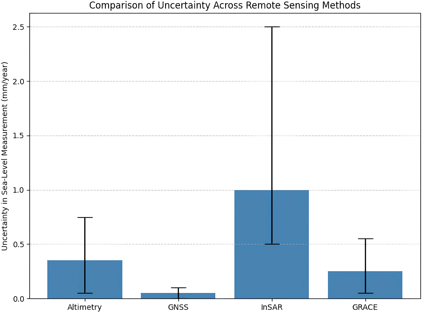
For global-scale monitoring, satellite altimetry (specifically the TOPEX/Poseidon, Jason, and Sentinel series) serves as the primary instrument for determining Global Mean Sea Level (GMSL) and regional trends, providing precise data on long-term eustatic trends (~3.3 mm/yr) and accelerations driven by thermal expansion and ice melt (Guérou et al., 2023; Legeais et al., 2021). While offering high accuracy for global averages with a trend uncertainty of approximately 0.3–0.4 mm/yr, altimetry accuracy degrades significantly within 10–20 km of the shoreline due to land signal contamination and waveform distortion (Liibusk et al., 2020; Legeais et al., 2021). To complement these geometric measurements, GRACE and GRACE-FO missions measure changes in the Earth’s gravitational field to quantify the mass component of sea level rise (caused by ice melt and terrestrial water storage changes) with an accuracy of 0.2–0.3 mm/yr and a spatial resolution of approximately 300 km, essential for closing the global sea-level budget (Cazenave et al., 2019).
At the regional level, sea-level variability is heavily influenced by ocean circulation dynamics and water budgets, often causing deviations from the global trend. Studies in the Northwest Atlantic and the Mediterranean demonstrate that fusing satellite altimetry with oceanographic data (such as steric height from Argo floats) and reanalysis models is essential to distinguish long-term climate trends from decadal variability caused by mass redistribution and steric effects (Biguino et al., 2024; Borile et al., 2025; Frederikse et al., 2017). However, on a local scale, monitoring shifts toward Relative Sea Level (RSL), where impacts are frequently dominated by Vertical Land Motion (VLM). In densely populated deltas and coastal zones, such as Tianjin and the Gulf of Mexico, subsidence rates driven by groundwater extraction can exceed global sea-level rise rates by an order of magnitude (Tang et al., 2021; Wang et al., 2020). Addressing this complexity requires an integrated approach that combines altimetry with Global Navigation Satellite System Reflectometry (GNSS-R), Interferometric Synthetic Aperture Radar (InSAR), and tide gauges to resolve high-resolution spatial variability (Hawkins et al., 2019; Lee et al., 2019; Tang et al., 2021). In this synergistic framework, GNSS serves as the “gold standard” for providing a stable geodetic reference frame and point-specific VLM calibration, while InSAR is utilized to detect ground surface deformation patterns such as subsidence or uplift across large areas with high spatial resolution (Tang et al., 2021; Wang et al., 2020; Zhao et al., 2021).
A distinct trade-off exists between global precision and local relevance. Satellite altimetry provides the global consistency necessary for understanding climate forcing and absolute sea-level trends (Guérou et al., 2023; Legeais et al., 2021) but often lacks the resolution required for local hazard mitigation due to coastal signal contamination (Hamlington et al., 2023; Liibusk et al., 2020). Conversely, tide gauges and GNSS offer high local relevance for assessing flood risk and Vertical Land Motion (VLM) but suffer from sparse and uneven spatial coverage (Hawkins et al., 2019; Lee et al., 2019). To bridge this gap, future research must prioritize extending coastal time series and using integrated approaches such as “virtual tide gauges” that fuse altimetry, GNSS, and InSAR to accurately decouple global climate signals from local ground deformation (Hawkins et al., 2019) integrated approaches such as “virtual tide gauges” that fuse altimetry, GNSS, and InSAR to accurately decouple global climate signals from local ground deformation (Hawkins et al., 2019). The most effective comprehensive monitoring strategy relies on this synergy: utilizing altimetry for global absolute trends (Legeais et al., 2021; Tang et al., 2021), GNSS and InSAR to resolve high-resolution local VLM and subsidence components (Tang et al., 2021), and GRACE/GRACE-FO to quantify the mass-driven components, such as ice melt, within the global budget (Cazenave et al., 2019; Yang & Francis, 2019).
Accurate monitoring of sea levels is the starting point for validating and predicting the future dynamics of the sea. Multi-scale data, including global sea levels, are important for designing adaptive and effective measures for the future. This means that the effectiveness of planning for sea-level adaptation depends entirely on the accuracy and availability of high-quality sea-level monitoring data, such as that provided by the Copernicus initiative (Legeais et al., 2021; Guérou et al., 2023; Biguino et al., 2024). The Dynamic Adaptation Pathways (DAPPs) tool provides an effective policy for managing delay factors in decision-making by implementing stepwise actions based on signals from continuous sea-level monitoring. Remote sensing data plays an important role as a sea-level monitoring tool, providing continuous spatial and temporal information that complements the inherent spatial disparity in locally measured tides. Remote-sensed information provides an effective means for quantifying and evaluating sea-level dynamics and thresholds, thereby reducing epistemic uncertainties in the timing of sea-level adaptations (Hamlington et al., 2023).
The complexity of sea-level rise (SLR) observed in the coast requires an integrated and interdisciplinary approach, which requires the involvement of various sectors such as climate science, earth sciences, and social sciences, to address policy-making decisions (Legeais et al., 2021; Borile et al., 2025). Apart from data integration, stakeholder engagement is an important factor in the reduction strategy. These factors and others above explain the combination and mutual interaction between technology, data, and the collaborative efforts of society for the proper conversion and use of scientific information for effective adaptations for policy makers. Although there are many benefits derived from the use of remote sensing data, there are many challenges involved, specifically the difference between the complexity of the raw data and the use and applicability of the information. In order to address the problem, there is therefore a need for the development and use of easily accessible derivative data sets, such as the use of the Copernicus Services and the appointment of experts who are utilized for the translation of signals into warning messages (Hamlington et al., 2023). The development and maintenance of homogeneity, continuity, and error characteristics are important for supporting data policy and observation of sea-level rise. This represents the backbone of sustainable development, as observed by the United Nations (Cazenave et al., 2019). Encountered water transport and the development of the budget for surface water require observation and continuous monitoring, which necessitate advanced assessment of significant threats and impacts to inform climate adaptation.
This study affirms that, between 1993 and 2021, the most credible approach to evaluating GMSL sea-level height remains satellite altimetry. However, an unprecedented strategy combining varied remote-sensing tools, for example, InSAR, GNSS-R, and sea-tide records, is needed to address the complexities observed along the coast. Studies have consistently shown that vertical land movement is the most dominant factor in relative sea level rise at the local level, which can be effectively detected using InSAR data. Despite advances in remote sensing technology, significant limitations remain, including altimetry accuracy in coastal areas, uneven spatial distribution, uncertainty due to short-term data records, and technical constraints on the latest methods, such as InSAR and GNSS-R. Future research should prioritize ensuring the long-term continuity of high-precision altimetry records beyond current missions, such as Sentinel-6/Jason-CS, by launching planned next-generation missions and maintaining orbit consistency for climate continuity. A primary focus should be on reducing altimeter sea level errors and better characterizing associated uncertainties, particularly by separating geophysical signals from empirically estimated short-timescale noise, as is being addressed by projects like ASELSU and FDR4ALT. Improvements in ITRF realizations are also crucial for GMSL stability, with newer versions, such as ITRF2020, offering potential advancements. Efforts are needed to investigate and reduce systematic errors in the sea level budget, with proposals such as the GRASP experiment aiming to integrate primary geodetic techniques. Infilling investment in the infrastructure and human capacity for the installation, maintenance, and quality control of the tide gauge data, as well as continuous evaluation of vertical land movement (VLM) for the tide gauge stations, the identification of the shore thinning process, and the rapid diagnosis of the tide gauge malfunctions, are critical for the observation of the coast. In the future, it would be important for the research to determine whether the observed biases are related to differences in bottom depth between GNSS and tide gauge stations. The development and growth of signal interpretation skill sets would play an essential role in the observation and explanation of the corresponding indicators for the data, namely the DAPPs. For the coastal prediction plan, there would be greater interest in future research to evaluate the transport of water for sea levels and the surface water budget, giving initial priority to the Mediterranean Basin. For research on sea levels and the corresponding increase, the development of the study on the processes and impacts would necessarily require collaboration across many disciplines. More analysis would be necessary for interannual sea levels along the corresponding coast, that is, the Atlantic Multidecadal Oscillation.
| Views | Downloads | |
|---|---|---|
| F1000Research | - | - |
|
PubMed Central
Data from PMC are received and updated monthly.
|
- | - |
Provide sufficient details of any financial or non-financial competing interests to enable users to assess whether your comments might lead a reasonable person to question your impartiality. Consider the following examples, but note that this is not an exhaustive list:
Sign up for content alerts and receive a weekly or monthly email with all newly published articles
Already registered? Sign in
The email address should be the one you originally registered with F1000.
You registered with F1000 via Google, so we cannot reset your password.
To sign in, please click here.
If you still need help with your Google account password, please click here.
You registered with F1000 via Facebook, so we cannot reset your password.
To sign in, please click here.
If you still need help with your Facebook account password, please click here.
If your email address is registered with us, we will email you instructions to reset your password.
If you think you should have received this email but it has not arrived, please check your spam filters and/or contact for further assistance.
Comments on this article Comments (0)