Keywords
coastal management, business model, European project, MI-SAFE
This article is included in the Innovations in Research Assessment collection.
coastal management, business model, European project, MI-SAFE
Flood risk management is a pressing challenge facing coastal managers worldwide, including in Europe. In the context of population growth in coastal areas, rising sea levels, and the potential increase in the frequency and intensity of extreme events, there is an increasing reliance on “grey” infrastructures such as dams, sea defences and sea walls. However, there is growing demand for more sustainable, cost-effective approaches to coastal protection, leading to increased interest in nature-based solutions, such as vegetated intertidal flats.
The Foreshore Assessment using Space Technology (FAST)1 (de Vries et al., 2018) project was conceived as a multidisciplinary endeavour to address coastal management issues, employing a synthesis of remote sensing and field data from vegetated intertidal flats across four EU countries (the Netherlands, the UK, Romania, and Spain). The primary objective of the study was to develop a package of services, designated MI-SAFE, to assess the potential of these ecosystems to reduce flood and erosion risks. The context for the FAST project is set by European policy guidelines on flood risk management, such as the European Commission Communication of July 20042, which highlighted the socio-economic impacts of floods and outlined a coordinated approach to managing risk in Europe. European funding instruments, including the Integrated Maritime Policy framework3 and the LIFE programme4, have provided substantial support for coastal protection and Integrated Coastal Zone Management (ICZM)5 initiatives. Despite this, implementing flood defences incurs considerable expense. Historically, European countries have adopted a reactive approach to this issue; however, there is an increasing recognition of the long-term benefits of investing in risk management.
The need to incorporate Nature-Based Solutions (NBS), such as vegetated intertidal flats, into coastal flood risk management strategies has driven demand for tools to assess their effectiveness. However, there are scientific and multidisciplinary challenges to be addressed, such as the need for a more comprehensive understanding of how vegetation reduces wave energy and how these processes scale from individual plants to large intertidal flats. Moreover, a considerable proportion of the budget allocated to research projects is often used to develop fundamental infrastructure. However, such investments are usually rendered futile once the project has concluded. This highlights the need for integrating long-term, sustainable business cases.
The FAST project sought to address these gaps by leveraging Earth Observation (EO) capabilities, evidence, and actionable information, particularly from the European Copernicus programme. Deltares6, a world-leading Dutch institute specialising in applied water, subsurface, and infrastructure research, as well as the development of software and forecasting systems, assumed a pivotal role in the project, serving as the project coordinator. The project also involved researchers from the University of Cadiz (Spain), the University of Cambridge (UK), GeoEcoMar (Romania) and NIOZ (The Netherlands). The FAST project adopted a multidisciplinary approach to address coastal management challenges. It involved combining remotely sensed data, particularly from EO sources such as Sentinel satellite imagery, with field-collected data. This approach was applied to vegetated intertidal flats in four EU countries: the Netherlands, the UK, Romania and Spain. These intertidal flats were meticulously mapped, and a comprehensive study was conducted to ascertain the impact of their distinctive characteristics on wave energy and erosion. A plethora of open-format information on elevation (topography and bathymetry), vegetation, water level and wave statistics was collected, reclassified or produced. The integration of these layers with intensive scientific fieldwork facilitated the establishment of relationships between elevation and vegetation properties, as well as water level and wave dynamics. These relationships were utilised to calibrate the open software wave model XBeach, thereby enabling the estimation of the effects of intertidal flat vegetation on wave attenuation and breakwater overtopping. The dissemination of this information was facilitated by OpenEarth, an open-source initiative dedicated to archiving, hosting, and disseminating data, models, and tools for the benefit of marine and coastal scientists and engineers.
The primary output of the project is the MI-SAFE software package, a service platform designed to assess the risk-reducing potential of vegetated coastal areas, such as salt marshes and floodplains, within flood and coastal erosion risk management strategies. The FAST project has generated MI-SAFE by collecting, reclassifying, and producing open-format information layers on elevation, vegetation, water levels, and wave statistics. The relationships between elevation and vegetation properties and between water level and wave dynamics have been established and utilised to calibrate the open-source wave model XBeach. This has enabled the estimation of the effects of coastal vegetation on wave attenuation and levee overtopping. MI-SAFE employs a multifaceted approach to achieve this objective, leveraging a combination of data sources. These sources comprise a knowledge database featuring algorithms validated through field studies, Sentinel EO observations, and other global online information, including tidal data.
Additionally, local data sources are incorporated into the system, enhancing its comprehensive, integrated nature. MI-SAFE integrates ecosystem engineering concepts into coastal protection, offering a standardised service platform for integrating ecosystem properties into flood risk management strategies. The objective of this initiative is to enhance the effectiveness of existing methods in coastal wetlands and to promote the adoption of NBS solutions.
The services offered by MI-SAFE are primarily structured around two principal components. Firstly, the MI-SAFE viewer constitutes a user-friendly web platform accessible online, serving as the primary vehicle for distributing and demonstrating services. It facilitates the exploration of information on vegetated intertidal floodplains worldwide, enabling users to learn about their characteristics and their role in natural flood protection. The viewer supports two display modes: The term “data” refers to the presentation of map layers containing environmental information. At the same time, “results” denotes the provision of outcomes derived from MI-SAFE models. The software includes an evaluation function that facilitates agile software development by incorporating user feedback. Similarly, advanced-level services are available upon request from the FAST team. It is asserted that the purpose of these services is to provide customised solutions for users with specific requirements. Indeed, the levels or modalities of services offered by the MI-SAFE package are developed in three levels:
• Basic level - MI-SAFE Educational Modality: Intended for a general audience and for educational or demonstration purposes. The information is global in scale, highly uncertain, and should be used strictly as a demonstration tool. The software includes a map viewer with interactive visualisation and analysis, which highlights the presence of vegetation and its potential to reduce wave height. The provision of information regarding the status of the ecosystem and its role in mitigating flood risk is facilitated. Access to the site is free.
• Intermediate level - MI-SAFE Expert Modality: This expert modality provides enhanced services, offering input, information layers, and more detailed data on the effects of vegetation on levee crest height requirements under various storm surge scenarios. The system provides high-resolution results at specific FAST project study sites, where in situ and satellite data have been calibrated and validated. It facilitates the download of Sentinel data and value-added products and offers “quick scans” of the disaster risk reduction potential in areas with limited data availability. Access to the site is free.
• Sophisticated level - MI-SAFE Advanced Modality: The system provides customised solutions and a range of services on request, satisfying the needs of prospective clients. The utilisation of sophisticated XBeach model data and configurations facilitates the generation of bespoke assessments quantifying the impact of intertidal flats and floodplains on wave height at a designated location and under conditions stipulated by the client. The range of services offered encompasses validation and calibration of new sites, as well as the development of new functionality. It is acknowledged that clients may require supplementary services in conjunction with the formalisation of commercial service agreements. Such services may include training, field sampling design, modelling, or assistance with data structures and reporting.
MI-SAFE is a unique service in several respects. Primarily, it combines global coastal coverage with high-resolution local analysis. Furthermore, it provides flood risk-related parameters for many areas of the world. The service is based on transparent, verifiable scientific knowledge, utilising automated coupling of Earth Observation, water-level, wave, and vegetation modelling. MI-SAFE relies on Open Geospatial Consortium data streams, is built with open-source tools, is supported by the Open Earth community, and offers versatile functionalities with advanced capabilities tailored to specific needs. Consequently, MI-SAFE makes a significant contribution to flood risk management in Europe and plays a crucial role in implementing the European Flood Directive.
Furthermore, MI-SAFE has the potential to estimate the role of vegetation in slowing floods during periods of high river flow. In summary, MI-SAFE is an integrated package of software and services centred on a web-based platform (MI-SAFE Viewer) that utilises Earth Observation data and modelling to assess the protective role of coastal and floodplain vegetation against flooding and erosion. It offers a range of service levels to meet the diverse needs of its users, utilising open technologies and data.
A fundamental element of such European projects is the search for long-term sustainability. The need to ensure the sustainability and ongoing operation of MI-SAFE beyond the FAST project’s funding period prompted the formulation of a business case and an exploitation strategy for the service package. The literature indicates that sound business cases, used effectively throughout the project’s lifetime, underpin governance and significantly improve the project’s success rate (Einhorn et al., 2019). A business case is a relative document that articulates the rationale for initiating a project or task, ensuring that the initiative has value compared to existing market alternatives and that resources are invested to facilitate the development of commercial activities. It summarises the anticipated benefits, both tangible and intangible, for all stakeholders, considers alternative options, and recommends a preferred solution (Krell and Matook, 2009).
The present manuscript outlines the business case development processes for the MI-SAFE package, with particular reference to its structure, market strategy, and the considerations and tools utilised by the FAST consortium to ensure its long-term viability. The overarching objective is to ensure the long-term sustainability of MI-SAFE. Following extensive deliberations, it was determined that this objective would be achieved through integrating MI-SAFE into the Deltares open-source community and providing advanced services. MI-SAFE is intended to be safeguarded by being incorporated into the Deltares software system, thereby facilitating its utilisation by the existing sales force, marketing plans and maintenance infrastructure. Furthermore, the FAST team will continue to provide support services through service agreements agreed with individual customers. This case exemplifies a multidisciplinary collaboration between experts in coastal management and marine sciences, on the one hand, and entrepreneurship and business management, on the other.
An agile development approach was used throughout the project to develop the MI-SAFE package. A central pillar of this methodology was the user-driven approach. This involved actively engaging with end-users and clients through interactive consultations and regional workshops. The tools used to develop the business model are listed below in the order in which they were applied.
Initially, the FAST team participated in a training workshop to equip them with the necessary skills and knowledge to conduct customer interviews using the method outlined by Blank and Dorf (2005). In the domain of entrepreneurship, customer interviews serve as a foundational tool for substantiating hypotheses about the market, the problem to be addressed, and the proposed solution (Chen et al., 2015). These interviews are characterised by semi-structured conversations with potential customers or users to gain in-depth insight into their needs, problems, behaviours, and priorities before launching a product or service into the market (Blank and Dorf, 2005). Conducting interviews with potential customers before the start of business development will provide the necessary information to assess the viability of the value proposition being proposed, in the form of a product or service.
Customer interviews are conducted in the early stages of the entrepreneurial process, especially during the problem and needs discovery and validation phase (e.g., in methodologies such as Lean Startup (Silva et al., 2020) or Design Thinking (Bason and Austin, 2019)), and are termed problem interviews (Blank and Dorf, 2005). These interviews can also be conducted at different times to validate new hypotheses or adjust the value proposition, and are known as solution interviews. In essence, interviews serve as a conduit for validating and/or refuting preconceived assumptions. The logic is straightforward: when a new concept is initiated, it is presumed that the client is confronted with these issues, that the optimal solutions are known, and that there is sufficient clientele to establish a profitable business. It is anticipated that the following hypotheses will be addressed through problem interviews (Blank and Dorf, 2005).
A script was established for the interviews, allowing each FAST member to adapt according to the interviewee. The following structure was observed in the interviews:
• A cordial welcome was extended, during which the purpose of the conversation was explained to the interviewee without revealing the solutions being devised (to avoid potential bias in the responses).
• Demographics. The interviewee was invited to provide information about their professional background and offer a personal description, including their age, occupation, and the nature of their responsibilities.
• The interview began with a discussion of the challenges the interviewee faced in daily coastal management. The aim was to take them to the point where they might need MISAFE services.
• Time to go deeper. The interviewee is then taken through each of the problems they have identified, asking them to explain the process involved in carrying out the tasks where the issues arose. Questions are asked, such as: What objectives does the interviewee pursue in carrying out these tasks? What solutions are currently being used? How complicated are the current processes? What do they entail in terms of economic costs? Among others.
• Ranking of problems. Based on the issues the interviewee has verbalised in the previous phase, they are asked to rank them from most to least intense, based on their experience.
• Commitment. As a farewell, in addition to thanking them for their time and participation, a double commitment was desired. On the one hand, to prevent them from directing other people to talk to them. This would enable us to expand our network of contacts with interested end-users and clients. The second commitment was to ask him if we could come back for a solution interview, i.e., to present him with a demo or prototype of MISAFE.
The international FAST team successfully overcame the initial reluctance of scientists who were unfamiliar with this entrepreneurship tool and lacked knowledge of conducting interviews. The team then compiled a list of potential key users and customers to interview.
A first round of end-user interviews was performed. Every FAST partner conducted this consultation in their own countries to introduce users to the FAST project and the potential of GMES/Copernicus data products and services, assess the specifications of end-user needs, document experiences with managing foreshores and floodplains, and evaluate the value of new products and services to different user groups. Through these interviews, they gathered fascinating information, such as
Content – the tool should
- ‘Provide actual and validated monitoring information on the most important indicators of foreshore status and system working’
- ‘Support planning, design, maintenance and testing of foreshore about levee requirements’
- ‘Support assessment of application requests about current legislation’
- ‘Support participatory policy-making process’
- ‘Provide scientific data on foreshore state, sea level, bed stability, morphology, sediment dynamics, and functionalities to handle these’
- ‘Provide impacts on potential management interventions’
Technology – a tool should
- ‘Be compatible or interoperable with existing software/ICT’
- ‘Be easily accessible (simple, tangible, visual, flowcharts, etc.) for non-specialists’
- ‘Be useful for providing additional consultancy services regarding the interpretation and use of the information’
- ‘Provide possibilities to add and process local data’
- ‘Be available during project lifetime and beyond’
After carefully analysing the answers, they organised a list of potential services according to the demand of the different end-users, including:
1. Ecosystem status information
2. Expert data quality outputs for non-specialists
3. Local data upload and integration
4. Long-term data availability
5. Management tool
6. Manipulation predictive tool (foreshore assessment and impacts)
7. Network adaptation (Interoperability)
8. Scientific interpretation functionalities
All members of the FAST team conducted two rounds of end-user consultations in each partner country. The purpose of these consultations was to understand users’ real problems and shape the tool to meet their specific needs. The information gathered during these consultations was essential for the subsequent development of the tool. The list of potential services was used to select three types or levels of MISAFE services described above.
Preliminary sector and market analysis, in conjunction with our partners’ perceptions of demand for such services, indicates the economic viability of developing relevant MISAFE services. A thorough investigation of available sector data has revealed several reports that are incomplete and/or inconsistent. To illustrate this point, the Parliament of the United Kingdom7 published an analysis of flood defence spending in England in 2014, which contains the relevant information:
1. Annual flood damage costs are estimated at around £1.1 billion and could reach as much as £27 billion by 2080.
2. It has been estimated that maintaining existing levels of flood defence would require flood defence spending to increase to over £1 billion per year by 2035.
3. There was a significant increase in flood defence spending from 1997 to 2010—spending increased by three-quarters in real terms.
4. DEFRA (Department for Environment, Food & Rural Affairs) expects to spend at least £2.1billion on flooding and coastal erosion over the next four years, only a slight decrease on the £2.36billion spent over the last four years.
Moreover, in February 2014, the UK government made a series of announcements about recovery and spending. The primary points of these announcements were as follows:
a) An additional £130 million for emergency repairs and maintenance.
b) 42 new flood defence schemes for 2014-15, which, together with other projects beginning construction in 2014-15, will protect more than 42,000 households.
c) £370 million in capital investment to improve flood defences in 2015-16, followed by the same in real terms each year, rising to over £400 million by the end of the decade.
d) A six-year programme of work running up to 2021, including a new long-term investment strategy on flood defences and assessments of the future need for flood and coastal defences, taking account of the latest risk maps and economic analysis.
Similarly, in the Netherlands, the budget for the second National Flood Protection Program (HWBP-2)8 amounts to €3.218 million. Overall, and translating both reports, we can highlight some key points: European governments, insurance companies, engineering firms, and consultants are seeking more ecologically sustainable, cost-efficient, and accurate defence modes.
In this sector, Deltares (project coordinator) is one of the leading institutes worldwide, providing expert knowledge and scientific-level analyses. As an autonomous institute for applied research, it operates on a global scale in the domain of water, subsurface and infrastructure. Deltares is an organisation that does not seek to generate profit. A total of 46% of its revenue is supported by the Dutch government, with the remaining 54% being sourced from public and private sector clients. It employs almost 800 researchers and consultants in the fields of hydrodynamics, coastal engineering, industrial flow technology, geoengineering, water quality, ecology and social sciences. Of these, approximately 150 are classified as environmental consultants. The institute is committed to the idea that software should be widely disseminated and open source to support further scientific development. Profitability in terms of financial gain is a secondary (soft) objective. The primary issues relevant to water security identified during consultations with new clients are as follows: Deltares asserts that it has completed project work in more than 80 countries worldwide.
Likewise, a competitor analysis has been developed. Table 1 summarises some results, showing relevant competitors and potential allies.
The FAST services are characterised by the integration of scientific findings and a development process oriented towards end-user needs. The project integrates these services into the current practices and working environments of various governmental, research, and commercial user communities active in these areas. Consequently, several potential target markets and client segments have been identified:
• The engineering community (including SMEs) can utilise FAST services to provide physical boundary conditions for cost-effective safety infrastructure, such as levees, that meet design and construction requirements.
• Government organisations (whether national, regional or local) responsible for the maintenance of safety infrastructure are at liberty to utilise the FAST services to evaluate the present and future status of safety infrastructure, including foreshores.
• International research institutes involved in researching and analysing the impacts of climate change on society may apply for FAST services to investigate threats to the safety infrastructure. The services can then be used to develop innovative solutions that embed (or restore) foreshores and floodplains within a safety philosophy.
• It is recommended that international governmental branches and non-governmental organisations concerned with the management of foreshores and adjacent systems, from the viewpoint of maintaining or creating natural values, evaluate the balance between nature conservation and enhanced stability and safety infrastructure.
• European civilians are the end users who benefit indirectly from FAST services.
To explore the possibilities in greater depth, two market analyses have been developed. These analyses reviewed the original list, incorporating, excluding, or rectifying it through interviews with a list of end-users and clients. The results obtained demonstrate a balanced distribution across various potential segments.
• It is estimated that 40% of public administrations are responsible for management and/or promotion.
• The analyses revealed that 28% of private companies typically provide services to the public administration. The provision of services by private companies to the public administration is often necessitated by the public sector’s lack of flexibility, which may stem from a lack of expertise, workforce, or technological resources. Alternatively, the decision may be influenced by the cost-effectiveness of private sector solutions.
• It is estimated that 32% of universities and research institutes, as well as non-governmental organisations (NGOs), can be both wetland owners and influential stakeholders in the development and implementation of wetland management strategies. Research institutions can develop or initiate improvements in the performance of management and promoters, which is particularly interesting.
Globally, billions of people are reliant on flood defence infrastructure for their safety. Furthermore, the financial burden of constructing, maintaining and managing flood defence infrastructure is significant. Moreover, the majority of dams and levees are designed and built from a single perspective, namely hydropower or flood defence, and often conflict with ecosystem integrity by obstructing water and sediment fluxes and by serving as barriers between water and land. To curtail expenditure and mitigate the deleterious effects on ecosystems, solutions that integrate natural systems with flood defence structures are currently being explored in several countries. In this scenario, FAST provides a detailed exposition on estimating climate robustness and the capacity of foreshores and floodplains to mitigate the effects of climate change. Consequently, the focal point of the discourse is “Environmental and Climate Change Impacts and Attribution”.
To analyse the FAST micro-environment, drawing on business strategy development, a SWOT analysis of the strengths, weaknesses, opportunities, and threats (SWOT) associated with our services was conducted. SWOT analysis is a widely used diagnostic tool in environmental management to identify key factors that influence the success or failure of a project (Hovardas, 2015; Sinha et al., 2020). According to Hovardas (2015), the project’s capacity to achieve its objectives is evaluated in terms of two distinct categories of factors: inner (i.e., those intrinsic to the project itself ) and outer (i.e., external to the project). The mobilisation of these factors is instrumental in achieving the project’s objectives. The inner aspects are called ‘strengths’, while the outer elements are called ‘opportunities’. Similarly, project barriers (termed ‘weaknesses’) and environmental barriers (termed ‘threats’) can be identified. The result of the SWOT analysis offers insights concerning the trajectory of the project, categorised as follows: ‘strengths’ that should be supported (i.e., inner potential), ‘opportunities’ that have to be sought (i.e., environmental prospects), ‘weaknesses’ that must be overcome (i.e., inner barriers), and ‘threats’ that ought to be alleviated (i.e., environmental hindrances).
In summary, as illustrated in Figure 1, a positive outlook is indicated for future steps. Further rigorous effort is necessary to translate these strengths and opportunities into reality. It is key that they devise conversion strategies to transform weaknesses or threats into strengths or opportunities, or at the very least, mitigate their impact. As previously mentioned, an example of a conversion strategy is the development of new, customised services and functionalities involving third parties.
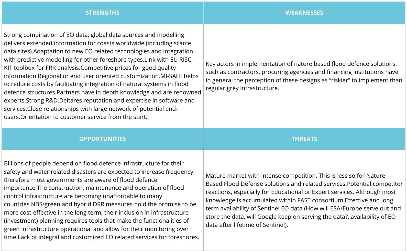
Legend: Matrix detailing the Strengths and Weaknesses (internal factors), as well as the Opportunities and Threats (external factors) identified for the development of the MI-SAFE business model.
As previously mentioned, Deltares is involved in developing innovative solutions, innovations, and applications that benefit people, the environment, and society. The institute collaborates with governments, businesses and research institutes in Europe and abroad. It was mutually agreed upon by the partners involved in the FAST project that Deltares would assume responsibility for the commercialisation, development and maintenance of the software’s operational status throughout the project period. Furthermore, it was agreed that Deltares would continue to host this software on public servers following the project’s finalisation.
Deltares Systems is the brand under which the organisation offers all software services and ready-to-use software products. These products are available via the institute’s webshop. It contains a selection of the most popular software products and services from over 150 Deltares software products, which cover the entire spectrum of their expertise, including coastal waters and estuaries (Delft3D), rivers and urban water management (SOBEK), the design of diaphragm wall structures (D-Sheet Piling) and the stability of flood defences (D-Geo Stability). In the global market, Deltares employs a regional and national approach. The selection of regions and countries is based on strategic, market, and operational criteria. Its excellent knowledge distinguishes Deltares, as well as strategic cooperation agreements and a focus on investment scenarios.
Regarding MI-SAFE, Deltares is held in high esteem on both the national and international stages. The organisation is specialised in the development of enhanced forecasting systems, designed to meet the mounting demand. This presents opportunities to integrate data and existing models with MI-SAFE.
• Deltares collaborates closely with other research institutes.
• Government departments and agencies are working closely together.
• Deltares also collaborates closely with private consulting firms.
A matter of increasing concern is the affordability of software maintenance. In this regard, Deltares’ international operations are increasingly characterised by the adoption of open-source software. This approach facilitates the utilisation of external expertise to enhance the MI-SAFE software, models and information systems. The increased availability of data enables the configuration of models to support policy development and decision-making within real-time warning systems.
In line with our previous analysis, our available resources, our capabilities and our values, the following conclusion can be drawn about our marketing strategy:
a) MI-SAFE is responsible for developing a Copernicus Downstream Service (DS) and software tool that combines Sentinel satellite image data with in situ measurements (from eight different foreshore case study areas in four countries) to assess the protective role of wetlands in flood risk management strategies.
b) MI-SAFE is integrated into Deltares’ overall services.
c) Following a series of interviews with end-users, a consensus has been reached on the definitions of basic and advanced services for the software system. In consideration of the range of functionalities expressed by end users and the operational software requirements, including tool processing speed, a range of web viewer versions has been developed to accommodate as many of the desired functionalities as possible. The web viewer is an interface that can be constructed using a variety of components to efficiently view and query a range of information services for a broad public. It is asserted that three modalities have been proposed as the foundation for the software design:
• A primary ‘quick scan’ mode has been developed to assess the potential of foreshores to mitigate flood hazards. It is anticipated that this mode will be both agenda-setting and of interest to a wide community of the general public and policymakers. This mode is characterised by its rapid responsiveness in the web viewer for a limited number of parameters for many foreshore locations. However, it is essential to note its limitation to a relatively coarse spatial and temporal scale.
• An advanced ‘assessment’ mode with more functionalities that extend beyond the basic modality to assess the flood hazard mitigation potential of foreshores. This mode should be regarded as the Minimum Viable Product (MVP). The MVP (Minimum Viable Product) is a tangible representation of a product or service with a limited set of features, deployed to learn the value of a potential solution through experimentation (Stevenson et al., 2024). This assessment mode is of interest to policymakers, consultants, and engineers. This mode incorporates numerical modelling results, thereby facilitating expedited responses in the web viewer across an extensive range of parameters, potentially reducing the set of foreshore locations and enhancing spatial and temporal scale.
• An Intervention and Evaluation mode that represents the most advanced iteration of the tool. In this mode, the user can evaluate the effects of scenarios by selecting different sets of boundary conditions or altering the foreshore status. This mode is of interest to the engineering community. This mode can deliver output to the web viewer for a further extended set of parameters, possibly for a reduced set of foreshore locations, with improved spatial and temporal detail, if relevant.
The software development process is based on the strategy and infrastructure of creating open-source software products. This signifies that FAST assimilates into extant open-source communities and can utilise open-source software modules developed in other research programmes. The FAST initiative is closely connected to the global community of practitioners in open-source software development. This affiliation is facilitated by the pre-existing software products that have been developed and are currently in use.
Furthermore, it is acknowledged that the development and utilisation of MI-SAFE software has the potential to yield a multitude of additional services for end users, thereby augmenting the value for professional users:
Existing open-source methods and tools are utilised as a context for the services provided. The initial version of MI-SAFE was developed as an online web viewer to provide users with a comfortable environment for accessing the available FAST web services. The web viewer is composed of a map viewer with dockable elements that possess specific functionality for data integration, map visualisation and visual analytics. MI-SAFE can be accessed from any location with internet connectivity. For instance, it can be utilised by consultants or public officials to evaluate the condition of the foreshore. The viewer incorporates an evaluation tool to facilitate the collection of user feedback. The Deltares Open-Source Community infrastructure serves as a platform for documenting and streamlining the process above. The design of the tool consists of seven main components ( Figure 2):
1. Extraction and delineation component
2. Information component
3. Intervention component
4. Interoperable WPS components toolbox
5. Open database service
6. Online interactive web viewer
7. Evaluation component
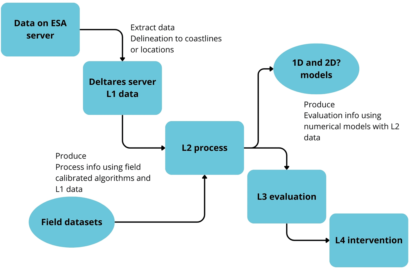
Legend: Schematic representation of the seven main components of the tool's design, illustrating the flow from the extraction of data from Earth Observation (EO) and local sources to the production of information using calibrated algorithms and the delivery of services to the end user through the web viewer.
The MI-SAFE tool uses four distinct data sources:
1. Knowledge database, consisting of field-validated algorithms and rules on how to convert images into information;
2. EO observations from Sentinel;
3. Other global online information, for instance, tidal datum and tidal range information; and
4. Local data sources include land use maps.
In the context of the MI-SAFE software, it is essential to note that the core processes are executed in an automated, reproducible manner. When feasible, Web Processing Services (WPS) or alternative database protocols are used to view, query, download, and process FAST products. In the cases where functionality is deemed sufficient, the WPS functions are available for utilisation in alternative user interfaces or as a downloadable script. The core processes encompass data delineation, correction, and collation. The integration of calibrated field algorithms and run model predictions is achieved through separate core processes. Moreover, a methodology is required to extract hydraulic information from an online source. The intervention component must incorporate mechanisms that facilitate the editing of boundary conditions, cartography, and the reiteration of other fundamental processes. It is acknowledged that all FAST maps may be published as NETCDF and GeoTiff files, with the subsequent capacity to feed WPS modules. It is noteworthy that both the FAST software and its associated databases are open-source. It is important to note that certain functionalities about service offerings may not be accessible to all users.
The MI-SAFE tool is integrated within Deltares systems as a comprehensive component, representing the most effective method for viability assessment. As previously indicated, Deltares is a globally renowned organisation. However, MI-SAFE is nonetheless viable in principle. As previously referenced, MI-SAFE, as an open-source program, is founded on the principles of communities of practice, thereby serving as an additional viability assessment. Furthermore, MI-SAFE derives revenue from two primary sources: advanced consultancy services (which are remunerated for the development of a customised system or additional modules) and a maintenance and support contract (which is optional for the client and which offers different levels of service depending on the urgency of the type of service, etc.).
The Fast team produced a financial forecast, incorporating anticipated revenues, expected profits and cash flows, for a standard scenario (i.e., the more likely one) of the MI-SAFE services. The financial projections for best- and worst-case scenarios were also included, along with the standard case. The scenario method is a process that enables the analysis of potential future events by considering alternative outcomes when the precise nature of the future is not yet apparent (Avagyan et al., 2022). A panel of experts was convened to produce a series of illustrative scenarios. A consultation was undertaken with customers, end-users and potential allies. The FAST partners are responsible for indicating what amounts are reasonable and assumable by their own customers, end-users, contacts and organisations. Therefore, the estimated potential revenue was calculated using the more moderate scenario for the initial five-year period, based on average prices (derived from Deltares’ systems portfolio).
In addition, despite pertinent documentation indicating an annual growth rate of 3%, this was not considered, given the cautious outlook. This forecast enabled the prediction of the net income statement, facilitating the evaluation of net income across various scenarios. Indeed, the majority of costs were calculated as a percentage of Deltares’ systems costs, thereby enhancing their results and engendering economies of scale. The remaining projected statements were redundant, as MI-SAFE is inherently incorporated into the Deltares systems. The financial projections have met with the approval of the fast consortia partners, thereby ensuring the sustainability of MI-SAFE services over time.
The business strategy was developed using the Business Model Canvas tool. According to Osterwalder and Pigneur (2010), the Business Model Canvas is a shared language for describing, visualising, assessing and changing business models. Each of the nine components of the Business Model Canvas is described in both pictorial and narrative detail. The further use of the canvas aims to translate business plans into customer-centric business processes.
As previously stated, the responsibility for the commercialisation, development and maintenance of the software’s operational status during the project period lies with the Deltares Institute. Following the project’s conclusion, Deltares will continue to host the software on public servers. Deltares collaborates with governments, businesses, and research institutes worldwide. Nevertheless, the FAST consortium has developed its own business model, which is outlined in the following canvas ( Figure 3).
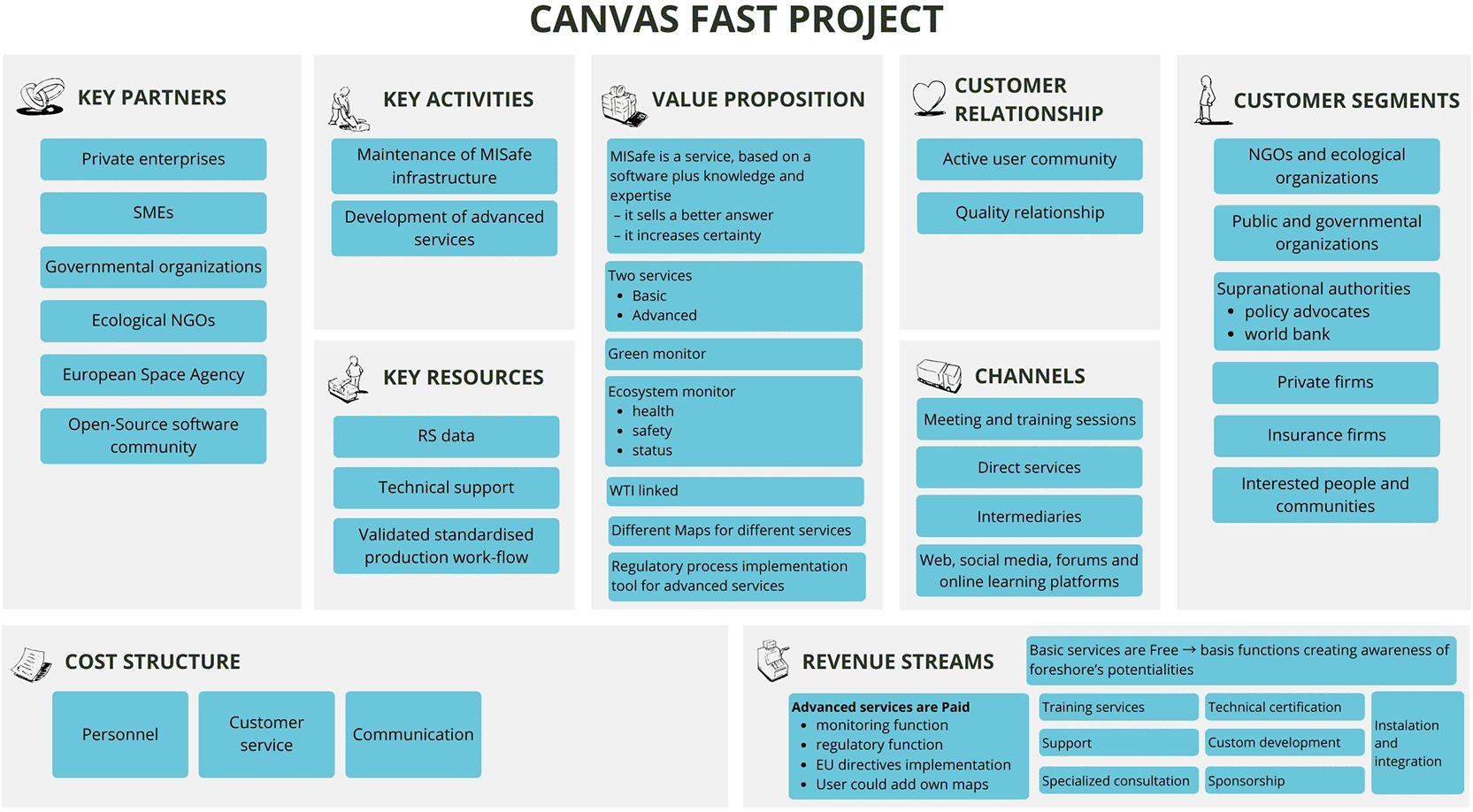
Legend: The Initial version of the business model canvas focused on a traditional linear product approach.
As illustrated in Figure 3, the customer segments are extensive and encompass the engineering community, governmental organisations, research institutes, international governmental branches, non-governmental organisations (NGOs), and the general public. Therefore, the end-users/clients were divided into six archetypes: non-governmental organisations (NGOs), research institutions, environmental organisations, public administrations, supranational agencies, private companies, insurance companies, and interested people and communities. As previously outlined, MI-SAFE has delineated a pioneering and singular operational service capability, providing intelligence on the condition of coastlines and floodplains, as well as the attendant repercussions on security infrastructure concerning prevailing and prospective physical forces and administration, for diverse target markets and customer and end-user demographics. The creation and activation of the community above facilitates the establishment of customer relationships. At the same time, the distribution channel is configured as mixed, either through Deltares’ direct means or through authorised intermediaries. The primary revenue streams are derived from advanced services, which are frequently characterised by annual agreements and customised development, as well as ancillary services such as new site calibration, consultancy, training, and support. A proportion of the revenue from these services is reinvested in the open-source infrastructure, thereby funding the hosting of the educational and expert modes. MI-SAFE’s unique value proposition lies in its ability to go beyond simply providing existing information and offering tools for local analysis and estimation of vegetation effects on wave attenuation, setting it apart from competitors. Its usefulness in environments with limited data is particularly valuable. The business model has been developed to address the challenges of the sector by seeking diverse sources of funding (including private and co-funding). The strategy of viability, achieved by subsidising fundamental and expert levels (freemium) through revenues generated by advanced and additional services, is a viable business model for open-source initiatives based on public research. While the knowledge generated by public funds is in the public domain, the added value in advanced services (customised analysis, consultancy, expert support) justifies the pricing structure. It allows for the maintenance and continuous improvement of the platform.
In the operational blocks of the Business Model Canvas, key activities comprise scientific development, the development of the MI-SAFE tool, interaction with users, data collection and processing, model calibration, the provision of services (educational, expert, advanced and additional), the building of a community of practice and the maintenance and development of the software. Key project resources include OT data (Sentinel), field data, algorithms developed for RS data analysis, models for predicting flood protection (such as XBeach), the OpenEarth platform, Deltares infrastructure and expertise, and the combined expertise of the FAST consortium. Key allies in developing the whole model include NGOs, public administrations, private companies, the European Space Agency, and the open-source software community. Ultimately, the long-term cost structure encompasses the maintenance of the IT infrastructure, personnel, customer service and marketing/promotion, among other elements.
Nevertheless, this business model is forsaken, and a significant transformation ensues, precipitated by introspection and discourse among the FAST project’s constituents. Consequently, a business model based on a platform-as-a-service is developed, as delineated below.
The business model evolved into a ‘Platform as a Service’ model, in which the portfolio of services is distributed through a web platform. Business model thinking has evolved away from the traditional value chain approach to a new logic based on open networks and platforms (Fehrer et al., 2018). According to Fehrer et al. (2018), this new business logic, based on open networks and platforms, challenges the notion that firms manage, influence, and control entire activity systems. Platform business models are systems that facilitate the creation, delivery and capture of value by enabling interactions between multiple user groups through digital or physical platforms. They typically leverage network effects, open networks and innovative monetisation strategies, which distinguishes them from traditional business models.
This evolution of the FAST business model towards a Platform as a Service is a strategic decision that enables and facilitates the integration of the various roles of the FAST consortium partners and the involvement of the open-source community. The platform model is generally well-suited for initiatives based on open-source and public data, as it leverages the diffusion and collaboration that are intrinsic to these communities. The rationale underpinning this evolution can be articulated as follows: The FAST project was initiated to facilitate the incorporation of nature-based solutions into flood risk management, to address the questions that had emerged from these innovative techniques. For instance, it is necessary to ascertain the mechanisms by which vegetation reduces wave energy, as well as how these processes are transferred from individual plants to large foreshores. However, the development of the business strategy has demonstrated that FAST offers a wide variety of value-added services, of which software is but a small part. This point suggests that the conventional linear value transmission model from the consortia to the customers may not be adequate for effective FAST business strategy modelling. In the course of developing its former business model, FAST has transitioned from providing value-added information to private and public organisations with an interest in coastal management to a platform that enables end-users not only to consume but also to create value, thereby multiplying it. For instance, the combination of global coastal vegetation and geographical data, previously unattainable, provided by FAST, could be helpful for several purposes. These include the original purpose of applying nature-based solutions to the development of new flood risk management strategies, as well as assisting and facilitating site selections for film producers. It is important to note that platforms do not merely create content and disseminate it. These systems empower users to generate and utilise value. From a technological standpoint, external developers can expand a platform’s functionality by leveraging application programming interfaces (APIs). From a business perspective, the platform enables a select group of users — producers — to create value for another group — consumers — who then have the opportunity to consume it.
The platform business model canvas (PBMC) provides a framework for the necessary transformation of management and the value proposition. To address this, a review of the previous FAST business model Canvas was undertaken, leading to the adoption of a new layout that enabled a more precise representation of value propositions and exchange opportunities for all stakeholders involved in the platform ( Figure 4). The PBMC is a strategic management and entrepreneurial tool used to describe, design, challenge, invent, and pivot business models. The Platform approach engenders a radical, rapid transformation in the client’s role. Consequently, end-users/clients can assume a more active role, transcending the conventional boundaries between consumption and production, contingent on the established configuration.
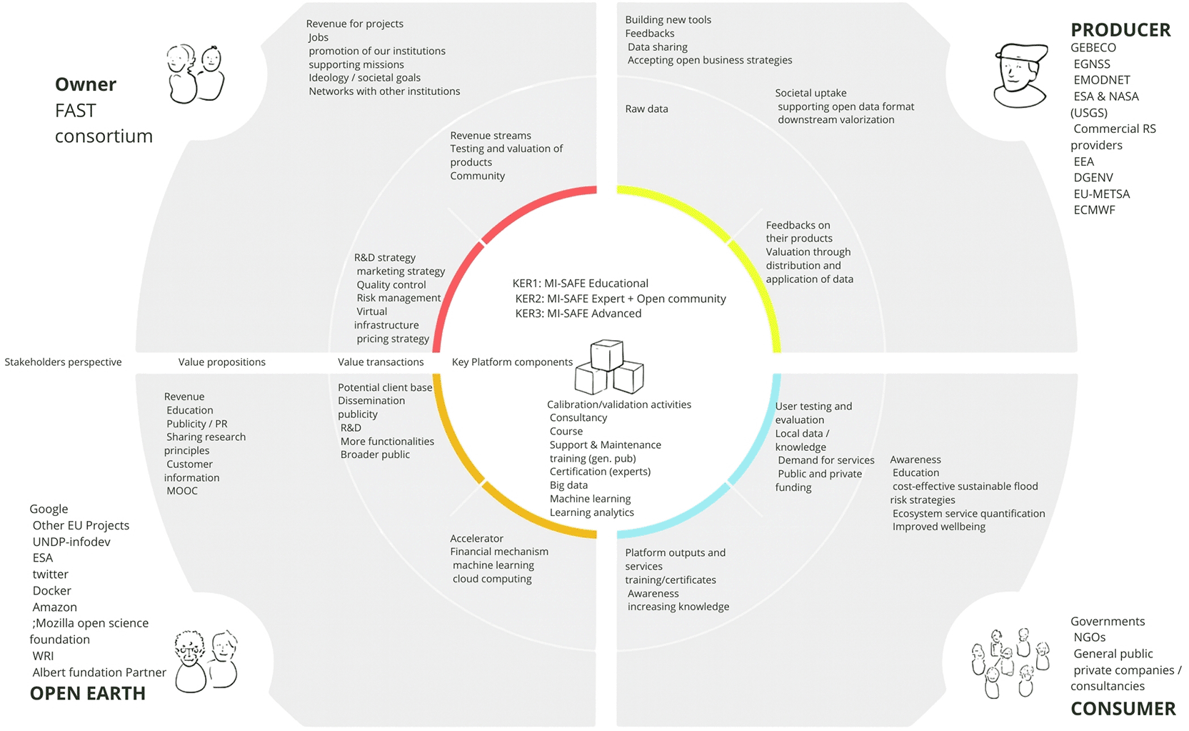
Legend: New business model design evolved towards a ‘Platform as a Service’ (PaaS). The diagram visualises the network of interaction between the four key segments: platform owners, producers (who co-create value), consumers (end users) and external partners, facilitating multidirectional value exchange.
As Kramer and Porter (2011) assert, the notion of creating shared value emphasises the interconnections between societal and economic progress. It has the capacity to catalyse the subsequent phase of global growth. The primary objective of FAST is to foster innovation and drive societal growth. The FAST Consortium provides a medium that facilitates exchanges between the FAST Consortium, producers, potential partners, and end-users in both directions. The creation of value is a key priority, and the PBMC is constructed around this principle. The novel configuration of the PBMC is predicated on the platform’s multi-peer business model. It is evident that users of the FAST platform function not only as customers but also as producers and configurators. This is attributable to the open-source basis, which enables the shaping of diverse stakeholder segments involved in the platform’s co-creation process. Consequently, this facilitates the generation of value, not only for the users but also for the platform itself. The PBMC facilitates the visualisation of the network, which is structured in the following segments:
• Stakeholders: In each of the four corners of the PBMC, one segment is allocated: owners, producers, customers, and partners.
• The owners of the FAST platform are the Consortia, whose constituents provide the foundational infrastructure of the platform and are accountable for the administration of the business processes associated with it.
• The following cornerstone is constituted by the producers, who primarily function as a data provider. The General Bathymetric Chart of the Oceans (GEBCO), the European Global Navigation Satellite Systems (EGNSS), and the European Marine Observation and Data Network (EDMODnet) are among the primary sources of data. The European Space Agency (ESA) is collaborating with the US Geological Survey (USGS) and NASA to provide observation data from the Copernicus and Landsat satellites. The ESA is also collaborating with the European Environment Agency, the Directorate-General for the Environment, the European Organisation for the Exploitation of Meteorological Satellites (EUMETSAT), and the European Centre for Medium-Range Weather Forecasts (ECMWF).
• Another cornerstone is the end-client segment, which comprises governments and other public administrations, non-governmental organisations, private companies, and consultancies.
• Partners are the fourth cornerstone, because it is key that the platform establishes a network of partners with a view to optimising the model. These partners may comprise private enterprises, including prominent technological companies such as Twitter, Docker and Amazon, as well as entities specialising in flood defence consultation and engineering. Additionally, the private sector encompasses small- and medium-sized enterprises, with a focus on aquaculture farms, fisheries, and private marinas. Furthermore, SMEs engaged in nautical activities, tourism and leisure sectors are also included. Public and governmental organisations, in conjunction with various special interest public agencies and organisations (e.g., towns, districts, and others involved in ensuring public safety, agriculture, conservation, and tourism), play a crucial role in this regard. In addition, the European Space Agency (ESA), the GMES consortium, the academic and scientific community, the United Nations Development Programme (UNDP), and the World Resources Institute (WRI) are also involved. Environmental, ecological, developmental and societal NGOs, as well as other civil associations, include, for example, open-source software communities, such as Open Earth and other EU projects, Mozilla, the Open Science Foundation, and the Albert Foundation in Monaco.
• The value proposition is as follows: Each of the segments enumerated above will receive a positive value proposition from FAST. Furthermore, the consortia will promote the institutions of its members, assist in fulfilling their missions, and enable members to achieve their ideological and societal goals. Moreover, the platform allows FAST consortia to establish and expand a network with other institutions.
In terms of producers, FAST provides them with the opportunity to develop new tools, receive feedback, facilitate data sharing for their products, promote social uptake, support and adopt open data formats, and employ business strategies and downstream valorisation.
In the context of end-clients, the MI-SAFE tool is designed to deliver a range of services contingent on the specific modalities and the particular needs of the end-user. These services encompass raising awareness, providing education on pertinent matters, valuing ecosystem services, developing cost-effective and sustainable flood-risk management strategies, and, ultimately, improving well-being. Conversely, the partners will receive revenues, in addition to educational resources, publicity/PR opportunities, the possibility of sharing research principles, customer information and Massive Open Online Courses (MOOCs).
• Value Transactions: In the context of a PBMC, the financial aspect is not invariably the primary value of the FAST project. Transactions on the platform also consist of data and services. The platform is responsible for providing the channels and infrastructure for these exchanges. In this way, the FST consortium implements R&D, marketing and pricing strategies, as well as quality control, risk management and virtual infrastructure. Regarding financial implications, a benefit of open-source platforms is that, after substantial development investments, they often exhibit inherently low costs. Consequently, the long-term cost structure of the FAST product encompasses the following elements: The primary responsibility of the role is to maintain the IT distribution infrastructure. In addition, the successful candidate will be expected to deliver personal services to customers and contribute to the organisation’s advertising and promotional activities. Conversely, the owners receive the majority of their revenue from the platform through various streams, primarily specialised consultation, public support, custom development, installation and integration, technical certification, and training services. Nonetheless, it is acknowledged that the progression of the FAST project will facilitate the identification of regional and end-user tailored service bundles, in addition to consolidating a community and testing and evaluating products.
Regarding the producers, the PBMC provides the raw data, and the producers themselves receive feedback on their products, as well as valuation through the distribution and application of data. In terms of consumers, their contributions include user testing and evaluation, local data and knowledge, demand for services, and private and public funding. In return, they receive heightened awareness of the situation, platform output, and supplementary services such as training and certificates.
Finally, partners can incorporate the following into the platform: financial mechanisms, machine learning techniques, cloud computing services, and acceleration mechanisms. In return, they will receive a potential client base, dissemination publicity, research and development activities and access to a broader public.
• Key platform components: The platform’s technical aspects have been identified as the fundamental basis for facilitating peer group growth. The FAST project establishes the three fundamental exploitation outcomes that align with the three modalities of MI_SAFE: educational, expert + open community, and advanced. Moreover, APIS, the platform, has been found to develop calibration/validation activities, consultancy, courses, support and maintenance, training for the general public, certification for experts, big data, machine learning and learning analytics.
The FAST project has successfully developed the MI-SAFE package. This innovative tool utilises Earth Observation and modelling to quantify the role of vegetated intertidal flats in reducing flood and coastal erosion risk. The present manuscript evidences the evolution of the business model, which has been developed into a Platform as a Service, integrating science, OT technology and end-user needs.
The structuring of MI-SAFE into three service levels (Educational, Expert, and Advanced) and the feasibility strategy, based on a freemium model, with the Dutch institute Deltares playing a central role in operations and commercialisation, provide a solid basis for the platform’s long-term viability and growth. This approach illustrates how publicly funded research can generate revenue streams from value-added services for professional users.
The MI-SAFE package is a significant contribution to flood risk management in Europe, providing actionable information and assessment tools that integrate ecosystem engineering concepts. It also demonstrates the potential of nature-based solutions supported by EO technology. Moreover, the business case presented here exemplifies a business model developed by a European research project, illustrating how such models can lead to the development of sustainable products with a wide-ranging social and economic impact. It exhibits how experts in coastal management and marine sciences collaborate with entrepreneurship and business management.
The present manuscript is, of course, framed within the action research paradigm, as the authors have been actively involved in developing the business model. Action research has been demonstrated to be a pivotal approach for enhancing academic teaching practice and student engagement in higher education, notwithstanding the limitations identified in the extant literature (Bradbury-Huang, 2010).
For this study, formal approval from an institutional ethics committee (IRB) was not sought, as the research does not constitute a clinical or biomedical study, but instead falls within the scope of business model development and market analysis. Human participation was limited to semi-structured interviews with professionals, coastal managers, and end users to identify technical needs and validate the MI-SAFE software’s value proposition. No medical data, biological samples, or sensitive personal information were collected. However, the study was conducted in accordance with ethical principles of transparency and informed consent: the purpose of the conversation was clearly explained to all interviewees, and they were invited to participate voluntarily and to provide information about their professional experience and the challenges they face in their daily management. Likewise, informed consent was obtained from all individual participants included in the study, who were duly notified of the scope and purpose of the research before their participation. This consent was given verbally due to the low risk of the professional interviews conducted and the fact that no sensitive personal data requiring written consent was collected.
| Views | Downloads | |
|---|---|---|
| F1000Research | - | - |
|
PubMed Central
Data from PMC are received and updated monthly.
|
- | - |
Provide sufficient details of any financial or non-financial competing interests to enable users to assess whether your comments might lead a reasonable person to question your impartiality. Consider the following examples, but note that this is not an exhaustive list:
Sign up for content alerts and receive a weekly or monthly email with all newly published articles
Already registered? Sign in
The email address should be the one you originally registered with F1000.
You registered with F1000 via Google, so we cannot reset your password.
To sign in, please click here.
If you still need help with your Google account password, please click here.
You registered with F1000 via Facebook, so we cannot reset your password.
To sign in, please click here.
If you still need help with your Facebook account password, please click here.
If your email address is registered with us, we will email you instructions to reset your password.
If you think you should have received this email but it has not arrived, please check your spam filters and/or contact for further assistance.
Comments on this article Comments (0)