Keywords
Forest Farm Interface, Biomass Carbon, Soil Organic Carbon, Litter
This article is included in the Climate gateway.
This article is included in the Agriculture, Food and Nutrition gateway.
This article is included in the Ecology and Global Change gateway.
Forest Farm Interface, Biomass Carbon, Soil Organic Carbon, Litter
The reviewers' comments and suggestions have been addressed in the updated version of this manuscript. The following changes have been made to improve the manuscript:
See the authors' detailed response to the review by Arshad Ali
See the authors' detailed response to the review by Sigit D. Sasmito
Over the last two decades, forests and forest management have changed dramatically. In 1990, the world's forest area was 4.13 billion hectares (ha) (31.6% of total land area of Earth). According to the UN's Food and Agriculture Organization, this area had shrunk to 3.99 billion hectares (30.6% of Earth's total land area) by 20151. Ethiopia's ecosystem is diverse, ranging from the dry lowlands in the east to the high altitudes of the central highlands (Hurni, 1998). The country's unique ecological conditions, as well as its rich flora and fauna, have made it one of the most important biodiversity hotspots on the world2. The country's forest land, on the other hand, has been rapidly shrinking over time. From 1990 to 2000, forest losses were estimated to 8.3 million hectares, and from 2000 to 2010, 5.2 million hectares3. This day major parts of the remaining natural forests which harbor high biodiversity are located on steep slopes at high altitude and in the remote southern and southwestern parts of the country. These few remaining high forests are also threatened by anthropogenic activities and converted to agricultural and other land use systems4. Similarly, other remaining natural forests have also been threatened by pressure from investors and changed to industrial plantation like coffee and tea4,5. This reduction and conversion of natural forest to other land use systems in many parts of Ethiopia has led to the decline in number and distribution of many plant species, shortage of raw materials for wood processing industries and disturbance of ecosystem services6. As a consequence, forest farm interface has expanded within and around the natural forest. Subsequently, it has resulted the expansion of forest farm interface in and around the forest ecosystem.
“For this study forest farm interface is defined as an area produced by forest encroachment that is officially unclassified as either forest or agricultural lands and is found in areas where intense economic activities such as crop farming, grazing, and the use of forest products predominate. It comprises lands managed by persons with no official use rights and found between natural forest and farmlands”7. For the past five decades, the government of Ethiopia has attempted to reforest degraded forests4,5. Hundreds of aid projects have been implemented in different parts of the country to reverse deforestation and forest degradation in the country. However, the success stories were below expectations and the problems are still immense. This resulted from the lack of effective management practices and quantification of the available forest resources. This insufficiency of scientific quantitative data brought lack of responsiveness for sound management of natural resources in the country.
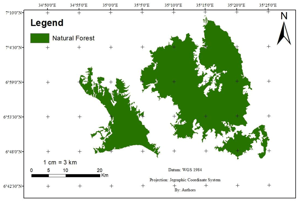
Gura-Ferda forest is one of the Afromontane rainforests in the southwestern region of Ethiopia and grows at altitudes from 700 to 2,300 meter above sea level. During the past decades, especially since 1984, large parts of this forest have progressively been disturbed and fragmented due to forest conversion to settlements, agriculture, and industrial plantation8. Nowadays, pressure produced by immigration and investors is increasing forest disturbance. However, there is no quantitative information on the change of species diversity and carbon stocks resulting from the conversion of natural forests to forest farm interface and farmlands. The overall objective of this study was, therefore, to analyze the woody species diversity and carbon stock change in association with the change of natural forests to forest farm interface and farmlands. The study hypothesized that, the conversion of natural forests to forest farm interface and farmlands affect the woody species diversity, biomass and soil organic carbon (SOC) stocks.
The study was conducted at Gura-Ferda district of southwestern Ethiopia which is located at 603 km southwest of the capital city Addis Ababa (Figure 1). Geographically, it is positioned between 6°29’12” N and 7°13’22” N latitude and 34°52’23” E and 35°23’59” E longitude. The area coverage of this district is estimated to be 2565.42 km2. The annual average rainfall over the period of 1983–2012 was 1639.8 mm, with a maximum of 1946.3 mm and a minimum of 1289.8mm. The area receives a maximum rainfall in October and minimum rainfall in February. The average annual temperature is 23.4°C with a range from 16.1°C–30.6°C. The dominant soil type of the study area is nitisols with soil textural class loam to clay9.
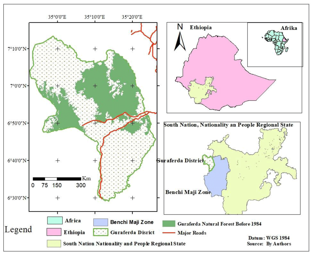
As the past data of the Gura-Ferda district specified, since 1984, there was a degradation of natural forest in the area (Table 1). The notable drivers of this forest area decrement were resettlement, crop investment and fuel wood. According to the office of Gura-Ferda district, in 1984, the populations of the district were 149. However, in 2016 they were increased to 45,02810. Moreover, during 2003/4 legal resettlement, massive deforestation of natural forest were accompanied for house construction of immigrates4,11. Next to resettlement, the taken up of forest by investors is other key drivers for the degradation and deforestation of natural forests in the area. According to 10, there were more than 30 investors who were involved in different agricultural investment especially coffee and rubber tree plantation. These investors had been used shrub land, natural forest, and grass lands for investment.
Data source. For the purpose of this research both primary and secondary data were employed. Primary data were obtained through field survey of the study area. Secondary data used were satellite images and publications such as articles, data from district land administration offices and censuses results. Multi-sensor and multi-temporal Landsat images were downloaded from United States Geological Survey (USGS) (https://earthexplorer.usgs.gov) (Table 2). Accordingly, satellite images of 1984 and 2016 were used for this study. Images of the year 1984 were taken because it was the time when the government organized a resettlement program at the study area. Similarly, images from the year 2016 was selected because it was the time when recent agricultural systems were expanded and government was focused on commercial investments in the area. Since it is a time of free atmospheric cloud, satellite images in the months of December to January were used.
| Acquisition date | Path/Row | Cloud cover (%) | Sensor type | Spatial resolution (m) | LU/LCC related events |
|---|---|---|---|---|---|
| 28/12/1984 | 170/055 | 0.0 | TM | 30x30 | Government Organized Resettlement Program |
| 26/12/2016 | 171/055 | 0.0 | OLI/TIRS | 30x30** | Recent Agricultural Expansion and focusing of government on commercial investments |
Stratification of study area. Before the resettlement program of 1984, all areas used for the sampling unit in this study time were covered by forest. However, nowadays, it is observed that the area has three discrete categories. These are: natural forest, forest farm interface and farmland (Figure 2; Figure 3).

Natural forest (NF): land with trees, shrubs and other vegetation that originally emerged on its own without the influence or direct intervention of man covering more than 0.5 ha and growing to a height of more than 2m and a canopy cover of more than 20%12.
Forest-farm interface (FFI): an area produced by forest encroachment that is officially unclassified as either forest or agricultural lands and is found in areas where intense economic activities such as crop farming, grazing, and the use of forest products predominate. It comprises lands managed by persons with no official use rights and found between natural forest and farmlands7.
Farmland (FL): an area which has been converted to intensive mono cropping with few/no scattered trees due to high disturbance
Sampling techniques. Three transects with a total of 30 plots (10 plots on each transect) were established on NF, FFI, and FL using a compass and a geographic positioning system (GPS). A distance of 200 meters (m) separated the transect lines and sample plots from each other13,14 (Figure 4). Each land use system's sample plot size was selected based on the expected density of woody species15,16. To collect vegetation data for both NF and FFI, a nested plot design of 400m2 with 25m2 and 1m2 size was employed (tree, sapling and seedling, respectively). Plot size of 50 m × 100 m was used for FL17. Seedlings with a height ≤ 50 centimeter (cm) and a diameter at breast height (DBH) ≤ 2.5 cm were counted from 1 m*1 m quadrat. Individuals with a height ≥ 50 cm and a DBH ≥ 2.5 cm were classified as saplings and counted. The diameter and height of all woody species with a DBH ≥ 5 cm were measured in the 400 m2 sample plots.

DBH of sampled dead wood was measured following the techniques used by 18 and 17. A complete list of woody species was made for each plot throughout the whole area and documented by local name. Species identification for common species was done in the field via different plant identification keys. However, for the less common species plant sample specimens were pressed and identified at the National Herbarium of Ethiopia, Addis Ababa University. Litter samples were collected from 1 m × 1 m subplot within the main plot. The collected fresh litter was weighed right on the site. Then the evenly mixed samples were taken to the laboratory and oven dried at 65°C for 24 hours to determine dry to fresh weight ratio. Soil samples were collected from the sub-plots used for litter sampling. Two sets of soil samples were taken, one set for the determination of organic carbon fraction (%C), and one set for the determination of soil bulk density. A total of 90 soil samples (layers of 0–30 and 30–60 cm) were collected for %C analysis using soil auger. In addition, similar size of undisturbed soil samples was collected separately for determination of soil bulk density.
Diversity analysis. Shannon-Wiener index (H`) was used to determine diversity of woody species of the study area. H` was determined through the analysis of two components of species diversity. These are the species richness (the number of species in the sample plots) and evenness of species (abundance distribution among species).
Where pi, is the proportion of individuals found in the ith species, S is the total number of species, and ln is the natural logarithm
Similarity measures are one of the most intuitive and often used methods for comparing two or more sites or samples in terms of species overlap. To compare the similarity and/or dissimilarity of NF, FFI, and FL, a percentage similarity index was calculated. This similarity index was chosen because it includes quantitative data (abundance) in its calculation, which overcomes the limitation of Sorenson’s and Jaccard's similarity index, which only consider qualitative data (species list). A matrix of percent similarity index makes it easy to interpret when comparing more than three sites19.
Where yki is the abundance of kth species at compared land use i and ykj is the abundance of kth species at compared land use j
Biomass carbon stock estimation. Allometric equation developed by 20 was used for estimating the aboveground biomass of woody species in NF (Table 3). Biomass of standing dead wood which has branches was also estimated using this allometric equation. This equation was selected since it was established for estimating the biomass of woody species in tropical natural forests. Moreover, this equation used diameter at breast height and wood density which was the most important biomass predictor variables. The biomass of woody species in FFI and FL was estimated using allometric equation developed by 21,22 since it was developed for land use systems having more or less similar climatic properties as those in the current study area. Woody density was taken from the document of Ethiopia’s fForest reference level submission to the United Nation Framework Convention on Climate Change (UNFCCC)12.
| Land Use | Equation | R2 | D (cm) | % C | Source | |
|---|---|---|---|---|---|---|
| Natural Forest | Woody species | AGB = ρ × d2 × H × 0.0559 BGB = 0.20 × AGB | - - | ≥5 ≥5 | 50 50 | 20 24 |
| Forest Farm Interface | Woody species | AGB = 0.225 × d2.341 × ρ0.73 BGB = 0.28 × AGB | 0.98 - | ≥5 ≥5 | 48 48 | 21,22 |
| Farmlands | Woody species | AGB = 0.225 × d2.341 × ρ0.73 BGB = 0.28 × AGB | 0.80 - | ≥5 ≥5 | 48 48 | 21,22 |
Aboveground biomass of standing dead wood which has no leaves was estimated following the procedure used by 18. The biomass of felled dead wood was estimated using allometric equation developed by 23. The total biomass of the dead wood was estimated by summing up of the standing, logged and felled dead wood. Finally, estimated biomass of woody tree species in NF, FFI and FL were converted to carbon (C) stock using carbon fraction value of 0.5, 0.48, and 0.48 respectively21,24. The loss on ignition method was used to estimate percentage of organic matter in the litter. The amount of C in the litter was estimated through multiplying of litter organic matter by 0.5025.
Soil organic C stock estimation (SOC). Soil analyses were undertaken at Wondo Genet College of Forestry and Natural Resources soil laboratory. The soil samples for bulk density were oven-dried at 105 °C for 48 hours. Bulk density was estimated by the core method26. The soil samples for %C were air –dried and analyzed using Walkley-Black method27. A SOC stock (Mg C ha-1) was determined through fixed depth method by multiplying of %C, bulk density (g/cm3), soil organic C fraction (%C) and soil depth (cm))25,28.
Where: BD soil is soil bulk density (g/cm3), %C is percent of organic C fraction, ODW is oven dry weight of soil (<2mm fraction) (g/cm3), CV is soil core volume (cm3), RF is mass of coarse fragments (g) = insignificant in our case, and PD is density of rock fragments (g/cm3) = 2.65 g/cm3
Total C stocks. Total C stock (Mg C ha-1) was calculated by summing up of biomass C stocks (above-and-below) and SOC stocks.
The stand structural parameter, diversity indices, biomass C stock and SOC stock data were described by mean and standard deviation. One-way ANOVA were performed (α = 0.05) to compare Shannon, Simpson, evenness, and C stocks among NF, FFI and FL. For SOC stock, two-way ANOVA was used since soil depth were considered as study factor together with land use types. Fisher's Least Significant Difference (LSD) post hoc test was used to compare means that demonstrated significant variations in SOC. All data were checked for normality prior to doing the analysis of variance using Kolmogorov-Smirnov test. The data were analyzed using Statistical Package for Social Science (SPSS version 20). All tests were conducted at 95% confidence level.
A total of 64, 27 and 21 woody species belonging to 37 families were recorded and identified in the sample plots of Gura-Ferda NF, FFI, and FL respectively (Table 4). Moraceae, with 29% of woody species, was the most well-represented woody species family in NF, followed by Rubiaceae (24%). Only one or two woody species were found in the other families. The 3rd and 4th most abundant families were Olacaceae and Fabaceae, respectively. In FFI, the Moraceae and Meliaceae families were the most abundant woody species families, accounting for 45% and 27% of all woody species, respectively. Euphorbiaceae and Moraceae were the most abundant family in FL. The Simpson (D) and Shannon diversity index (H’) value of NF is significantly higher (p=0.001) than that of FFI and FL. The D of FL was higher than that of FFI, but the difference was not significant. The H’ in NF was 1.91 and 2.52 times higher than the H’ of FFI and FL, respectively (Table 4). Evenness was significantly higher (p<0.05) in FL than that in NF and FFI.
The three land use types shared only 12 of the 70 woody plant species. The percent similarity index for NF with FFI, NF with FL, and FFI with FL was 10.95 %, 5.23 %, and 9.90 %, respectively. As a consequence, NF and FFI were the most similar, while NF and FL were the least similar. Woody species such as Albizia gummifera, Cordia africana, Croton macrostachyus, Diospyros abyssinica, Ficus sur, and Lepidotrichlea volkensi were common across all land uses.
The basal area of woody species in NF ((61.02±46.51 m2 ha-1) ) was 2.23 and 10.54 times higher than FFI (26.79 ± 12.16 m2ha-1) and FL (5.79±6.00 m2 ha-1), respectively (Table 5). The density of woody species in the study area was 1256.67±553.28 individuals per hectare for NF, 822.5±195.68 individuals per hectare for FFI and 110.83±70.92 individuals per hectare for FL.
The mean aboveground biomass (tree/shrub, dead wood and litter) C stocks of FFI (63.4±30.46Mg C ha-1) are significantly lower than the adjacent NF (132.75±132.61 Mg C ha-1), but significantly higher than that of FL (14.16±15.05Mg C ha-1). The mean aboveground biomass C stocks of NF were approximately 2.1 and 9.37 times higher than FFI and FL (Table 5). The mean overall dead wood C stock of the study area was 2.3 ± 2.84 Mg C ha-1 for NF and 5.6 ± 6 Mg C ha-1 for FFI (Table 6). The mean litter biomass C stock for aboveground biomass was 0.66 ± 0.29 Mg C ha-1 for NF and 0.5 ± 0.19 Mg C ha-1 for FFI.
A belowground biomass C stock in the NF was significantly higher (p< 0.001) than the belowground biomass C stocks of FFI and FL (Table 5). The mean belowground biomass C stocks in the NF, FFI and FL were 25.96 ± 22.76 Mg C ha-1, 11.46 ± 5.93 Mg C ha-1 and 2.83 ± 3 Mg C ha-1 respectively. The total biomass C stocks in NF was by 2 % and 18.5 % higher than FFI and FL. From the total biomass C, the contribution of dead wood and litter covers only 1.4% and 0.4% in NF, respectively, while, it covers about 6.9% and 0.6% in FFI.
Within each land use, %C and SOC stock was significantly higher (p<0.001) in the top layer (0–30cm) than in the lower layer (36.9% and 0.6% 0–60 cm) (Table 5). The top layer stocked 57.11%, 55.46%, and 57.09% of the total SOC in the NF, FFI and FL respectively. The total SOC stocks (0–60 cm depth) were significantly different among all land uses. SOC stock significantly differs along depths for all land uses. With respect to conversion of NF to FFI, 22.5% of SOC stocks (0–60 cm) were lost. Similarly, 44.05 % of SOC stocks (0–60 cm) were lost in conversion of the NF to the FL.
The total C stock of the study area was calculated by summing up all the C value of each pool. Accordingly, the total C stock (Mg C ha-1) is significantly different among the three-land uses. The total C stock in NF was 388.54±161.63 Mg C ha-1. While the total C stocks for FFI and FL were 252.95±41.86 Mg C ha-1 and 145.58±25.94 Mg C ha-1 respectively (Table 5). Of which, the SOC accounted for 59.15%, 70.40%, and 88.33% for NF, FFI and FL, respectively. The total C stock of NF was approximately 1.54 and 2.67 times higher than that of FFI and FL.
The degree of human interference and disturbance caused by overexploitation of forest resources, overgrazing, the establishment of new settlements, and the conversion of forest to coffee plantation for long periods could be attributed to the variation in species composition among the NF, FFI, and FL of Gura-Ferda district. Almost all of the woody species found in the FFI and FL were not planted, but rather were left over from the conversion of the NF to the FFI and FL. The Gura-Ferda NF is floristically low when compared to other moist afromontane forests like Jibat humid Afromontane forest (183 species), Sirso moist evergreen Afromontane forest (74 species)29, and Bonga forest (243 species)30. It is, however, higher than Gendo moist afromontane forest (38 species)31 and Gole Forest (46 species) in Kamba district, Southern Ethiopia32.
As shown in Table (1), FFI which emerged after the resettlement program of 1984 accounts for 23.28% of the NF within 1984–2016-year interval. As reported by 11, and 10, the main problem related to land use land cover change at Gura-Ferda district was agricultural investment, fuel wood collection, wood for house construction and farm implementation, wildfire, resettlement, land certification, poor governance within the district, and subsistence agricultural land expansion.
According to Gura-Ferda district land administration report, large areas of extra land were recorded for each farmer. The farmers had expanded their farmland into nearby forest, shrub/bush land and grass land and used those land uses for commercial crop production. Therefore, this increment of unregistered or unplanned farms and FL resulted from above mentioned drivers are the main causes for the loss of woody species diversity in the study area.
The main reason for the lower woody species diversity in FFI in relation to NF in the study area is due to the application of intensive thinning of different woody species in the system in order to reduce shading effect. 33 also reported that, managing forest for coffee production has resulted in significant changes in species diversity, composition and vegetation structure in coffee forests of southwestern Ethiopia. The number of woody species recorded in Gura-Ferda NF is comparable to the Komba-Daga moist evergreen forest in southwestern Ethiopia (62 woody species)34. For instance, the number of woody species recorded in the Gura-Ferda NF of the current study area is substantially higher than those reported for Agama tropical Afromontane forest of Ethiopia (39 woody species)35. However, the number of woody species in the current studied NF is lower than the woody species recorded for Wondo Genet Afromontane forest in the central highlands of Ethiopia (72 woody species)36.
Our results also indicated that, the woody species richness in FFI of the current study is comparatively lower than woody of species in agroforestry system of south-central and southern highlands of Ethiopia37,38. Since maximizing coffee production is the main goal, most of the native trees have been cleared by cultivators and few shade plant species are retained in highly populated coffee shrubs.
The study showed how C stocks in biomass and soils were varied across different land use systems. NF had higher biomass C stocks compared to FFI and that of the FL. 39 and 40 reported higher biomass C in forest land use system as compared to other land cover types in northwestern Himalaya and northern Ethiopia, respectively. From the studied land use systems of this area, most of the C was stocked in NF. The accumulation of high C stock in NF was attributed by the presence of diversified woody species in the NF in comparison with FFI and FL. Additionally, the NF has found to accumulate larger aboveground biomass in the litter compared with that of FFI. This result is in line with the result of 40 which stated that tree density, diversity and diameter have an effect on biomass C.
Case studies have showed as different land use systems stocked different amounts of C in their biomass component. Accordingly, the biomass C stocks recorded in the NF of the current study area is substantially lower than the biomass C stocks of Adaba-Dodola community forest, southeastern Ethiopia41. The biomass C stocks of NF of the current study area was approximately three times lower than the biomass C stocks reported for woody plants of Mount Zequalla Monastery in Ethiopia42. Similarly, the biomass C stocks of FFI in this study was higher than that of the coffee based agroforestry system in Gera, Jimma Zone, South-West Ethiopia43. The difference in biomass C stocks might be due to various factors such as difference in diversity of trees (woody and non woody) of larger sizes, the used allometric equation, soil condition and climate factors. For instance, in the coffee based agroforestry system studied by 43, trees aboveground biomass was determined using44 allometric equations. But, for this study, the generic equation developed by 20 and 21 were used for woody tree species. The biomass C stocks of the FFI of the current study area was relatively equivalent with the total biomass C stocks of fruit coffee system of indigenous agroforestry systems of the south-eastern Rift Valley escarpment, Ethiopia45.
The average mean above ground biomass C stock of the FFI was higher than the mean biomass C stocks of organic polyculture coffee, non-organic polyculture coffee and organic Inga species in Chiapas, Mexico46. The variability among these systems in this respect might be because of differences in species composition, site characteristics, management practices, land holding sizes, ancillary factors (e.g. soil condition, climate, system age, land-use history), and adopted allometric model for biomass estimation47.
Concentrations of SOC decreased with an increment of depth in all NF, FFI and FL. The highest SOC stock in the NF might be attributed to the lower organic carbon turnover rate as a result of minimum soil disturbance in the system, and more litter fall inputs from different wood tree species. While in the FFI, common intensive management practices like cleaning, weeding, burning and relocation of biomass might influence accumulation of litter carbon. It was in agreement with results by 48 who claimed the diminishing trend of SOC content with depth in his study in Kafa, Southwest Ethiopia. 49 also observed a declining trend in SOC concentration with depth in the Central Rift Valley area of Ethiopia.
The total SOC stocks at soil depth for the three land use systems in this study were within the range of SOC stocks reported for other similar systems in Ethiopia50. The upper layer (0–30 cm depth) SOC stock of FFI in this study area was higher than the mean SOC (65.2 Mg C ha-1) of Nitisol soil under agroforestry systems in Ethiopia50. The result of SOC in 0–30 systems cm depth in FFI was also higher than the 0–30 cm depth SOC recorded in Gununo watershed agroforestry practices51, and 0–30 cm depth SOC (60.8 Mg C ha-1) of Indonesia homegarden agroforestry system52.
The results indicate that 22.5% and 44.05% of SOC stocks (0–60 cm) were lost in conversion of the NF to the FFI and FL respectively within 33 years. Another meta-analysis of 53 found that SOC decreased by 44.5% following conversion from a NF to a crop field. 54 also found that SOC decreased by 30.9% after 15 years of deforestation in the Bale Mountains of Ethiopia.
FFI in the southwestern part of Ethiopia plays an important role in maintaining more woody species and sinks of C. The higher contribution of NF to climate change mitigation is mainly due to the higher diversity and density of larger woody species in the system as compared to the adjacent FFI and FL. Trees in particular play substantial roles for enhancing biomass C stocks in forests and any other land use systems. However, the increment of FL found adjacent to the NF and FFI showed a lower role of biodiversity conservation and C stock. This shows that sustainability of the system is questionable. If the NF is not sustainably managed and certification of land is not carried out in the area, there will be expansion of FFI and FL which will cause further deforestation and forest degradation. Therefore, it needs to recognize FFI as part of climate change mitigation strategies, as it can also provide much benefit to the community and a potential to reduce pressure on adjacent NF. The quantified C stocks would be beneficial to Ethiopia's economy and environment, encouraging the country to contribute even more to global warming mitigation while also providing income. The estimated C sequestration potentials of NF, FFI, and FL along the natural forest to farmland conversion gradient will necessitate the implementation of sustainable strategies, collaboration among actors, and promotion of best sustainable land management practices in order to improve marketing channels and institutional settings for effective C trading.
| Views | Downloads | |
|---|---|---|
| F1000Research | - | - |
|
PubMed Central
Data from PMC are received and updated monthly.
|
- | - |
Provide sufficient details of any financial or non-financial competing interests to enable users to assess whether your comments might lead a reasonable person to question your impartiality. Consider the following examples, but note that this is not an exhaustive list:
Sign up for content alerts and receive a weekly or monthly email with all newly published articles
Already registered? Sign in
The email address should be the one you originally registered with F1000.
You registered with F1000 via Google, so we cannot reset your password.
To sign in, please click here.
If you still need help with your Google account password, please click here.
You registered with F1000 via Facebook, so we cannot reset your password.
To sign in, please click here.
If you still need help with your Facebook account password, please click here.
If your email address is registered with us, we will email you instructions to reset your password.
If you think you should have received this email but it has not arrived, please check your spam filters and/or contact for further assistance.
Comments on this article Comments (0)