Keywords
land-use areas, pesticide poisoning, spatial association patterns, pesticide use in Thailand
This article is included in the Agriculture, Food and Nutrition gateway.
land-use areas, pesticide poisoning, spatial association patterns, pesticide use in Thailand
Farmers use agrochemicals extensively to obtain high yields as well as being able to harvest in a timely manner that meets the market demand for a high price.1 Pesticides are parts of the agrochemicals widely used in most agricultural areas. These chemicals are considered as safe when used under a limited level following the proper application procedures. Some chronic diseases such as cancer, diabetes, Parkinson’s, and Alzheimer’s are reported to have direct or indirect relationships with pesticide exposures and develop related diseases.2 The use of pesticides has shown varying detrimental effects on humans as well as the environment. Presently, enough evidence is available to suggest their misuse and overuse in last few decades in most of the developing nations. Primarily, due to the lack of education, they are endangering the lives of farmers as well as the entire population and environment.3
Thailand ranks third for herbicide use per area and fourth in annual insecticide use compared to 15 Asian countries4 as most Thai farmers are still using a lot of agricultural chemicals.5 Both farmers and people living around the production area with long-term exposure to pesticides can develop chronic health effects such as neurotoxicity, gastrointestinal tract inflammations and cardiovascular related diseases.2,6 The organophosphates used in pesticides affect the nervous system which is one of the most common problems among agricultural workers. Many farmers are still not using full range of personal protection standards.7 There is a lack of rigorous legislation and regulations to control pesticides use in developing countries.8 So, pesticide related disease is one of the major public health problems in Thailand.9 However, the spatial impact assessment of pesticide poisoning for further planning and policymaking to explore areas with a high risk of using chemicals is still underexplored in Thailand. Therefore, this study aimed to determine the spatial association of each type of land used and diseases associated with pesticide pollution in Thailand to provide comprehensive information to the policy makers and also provide recommendations related to health risk control which will further enhance the quality of life of the farmers.
This study was approved by the Ethics Committee in Human Research of Khon Kaen University, Khon Kaen, Thailand (Reference no. HE652049).
All 77 provinces in Thailand were included which occupy an area of 514,000 square kilometers, which consists of 511,770 square kilometers of land and 2,230 square kilometers of water. Thailand shares borders with the following neighboring countries: Myanmar, Cambodia, Laos, and Malaysia.
The geographic coordinates of the administrative areas used in this study were collected from the DIVA-GIS (http://www.diva-gis.org/) online publicly available database.10 This cross-sectional analytical study used two datasets for analysis:1) A data set on status of patients with disease occurred by pesticide pollution and diagnosed on the basis of ICD10 code: T600, T601, T602, T603, T604, T608, T609 in January 2018-December 2020 from the occupational and environmental diseases report of Health Data Center (HDC), Thailand,11,12 and 2) Agricultural area distribution data on the agricultural statistics of Thailand report from the Office of Agricultural Economics, Thailand.13,14 There was no inclusion or exclusion criteria applied to the data accessed in these reports.
The independent variables of this study were types of land use areas for agricultural consisting of rice field areas, field crop areas (sugarcane, cassava, peanut, common tobacco, corn, and potato), fruit trees and perennial areas (including rubber trees, eucalyptus trees, and palm oil trees), vegetables and flower areas, and then other agriculture areas in the years 2018-2020, in Thailand. The dependent variable was the proportion of diseases related with pesticide pollution (insecticide and herbicide) in the provinces for the years 2018-2020 excluding Bangkok because data from Bangkok was not reported on the HDC.
This study used the Quantum GIS program (https://qgis.org/en/site/) to describe the spatial distribution patterns of agricultural areas and the proportion of patients infected with pesticide related diseases in the provinces of Thailand. The GeoDa program (https://geodacenter.github.io/) was used to analyze spatial autocorrelation by specifying XY-coordinates to automatically calculate distance between different points or centroids of polygons. It can further be specified for the threshold distance to determine the minimum distance for two units to be considered as neighboring provinces. For connecting as a criterion to identify groups which using the weight matrix to analyze spatial correlation.15,16
Moran’s I spatial autocorrelation test statistic was performed to identify global autocorrelation within Thailand. The global autocorrelation statistics provide a single measure of spatial autocorrelation for an attribute in Thailand as a whole15,17 by an Empirical Bayes (EB) standardization as a means to correct Moran’s I spatial autocorrelation test statistic for varying population densities across observational units.
The reports of the Empirical Bayes Index (EBI) Moran scatter plot observed a plot with the spatially lagged variable on the y-axis and the original variable on the x-axis. Both variables were standardized and the graph was divided into four quadrants: high-high (HH) and low-low (LL) indicating positive spatial autocorrelation; and high-low (HL) and low-high (LH) indicating negative spatial autocorrelation. The slope of the linear fit to the scatter plot equals Moran’s I.15,18 The expected value of Moran’s I is -1/(n - 1), and the interpretation is similar to that of the product-moment correlation coefficient. Informally, +1 indicates strong positive spatial autocorrelation (i.e., clustering of similar values), 0 indicates random spatial ordering, and -1 indicates strong negative spatial autocorrelation (i.e., a checkerboard pattern).15,17 Then, a LISA was used to determine the local spatial autocorrelation patterns of the variables.17,19 This computes a measure of spatial association for each individual location.
The maps depict the locations with significant Local Moran statistics (LISA significance maps) and classify those locations by type of association (LISA cluster maps).15 The dark red is an indication of spatial clusters when having a high frequency of land used with a high frequency of patients infected with pesticides-induced diseases among the identified median of three neighboring provinces (high surrounded by high or hot-spot). The dark blue location is indication of spatial clusters when a low frequency of land used with a low frequency of patients acquired pesticides induced diseases in the identified province with neighboring provinces (low surrounded by low or cold-spot). By contrast, the light red and light blue are indications of spatial outliers (respectively, high surrounded by low, and low surrounded by high).15,19 The statistical significance level was 0.05. The simulation used 999 permutations to evaluate the sensitivity of the results (Figure 8 and Figure 11).
The average prevalence of pesticides-induced disease patients in the years 2018-2020 was 13.17 (95% CI: 10.83-15.50) per 100,000 population. We found that the highest average prevalence of pesticides-induced disease patients per 100,000 population in a province was between 25.39-55.28 when classified as decile in the Mae Hong Son, Uttaradit, Phitsanulok, Loei, Nong Bua Lam Phu, Nakhon Phanom, Nakhon Ratchasima, and Ang Thong provinces (Figure 1A). The highest average prevalence of pesticide-induced disease patients per 100,000 population were between 14.78-37.64 while classified on the basis of the insecticide (Mae Hong Son, Lampang, Uttaradit, Nakhon Phanom, Sakon Nakhon, Nakhon Ratchasima, Ang Thong, and Phetchaburi provinces) (Figure 1B). On the basis of herbicide, 6.36-16.14 per 100,000 population were having pesticide-induced diseases in the Mae Hong Son, Nan, Phetchabun, Loei, Nong Bua Lam Phu, Nakhon Ratchasima, Sa Kaeo, and Chai Nat provinces (Figure 1C).
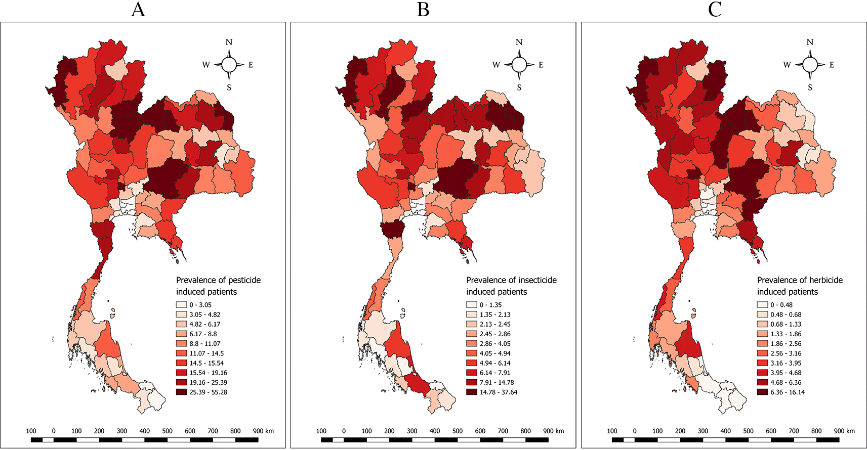
A: Distribution of the average prevalence of pesticide-induced patients per 100,000 population in years 2018-2020.
B: Distribution of the average prevalence of insecticide-induced patients per 100,000 population in years 2018-2020.
C: Distribution of the average prevalence of herbicide-induced patients per 100,000 population in years 2018-2020.
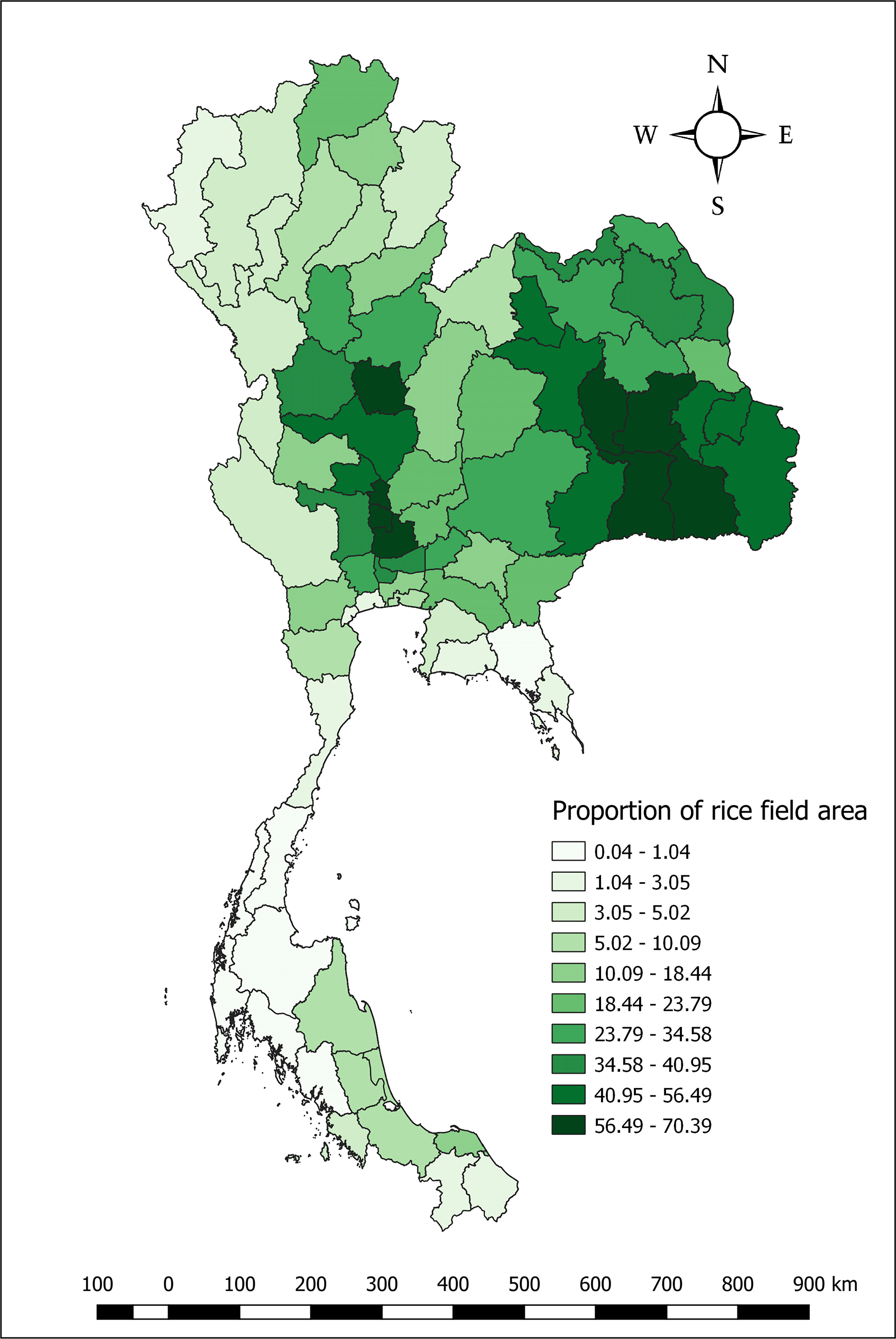
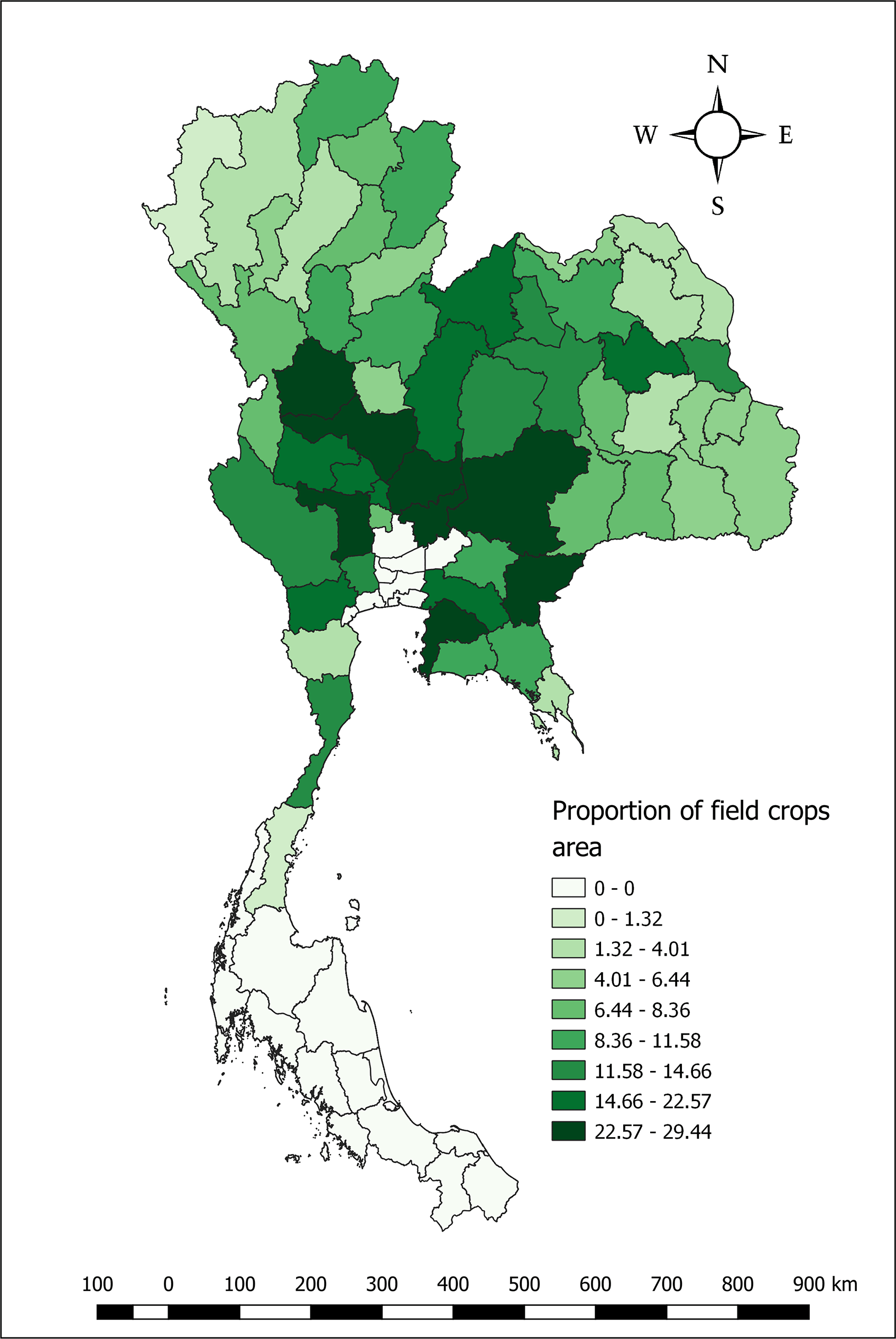
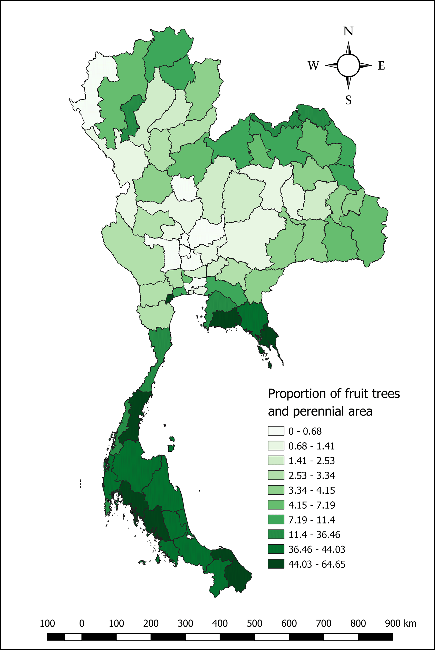
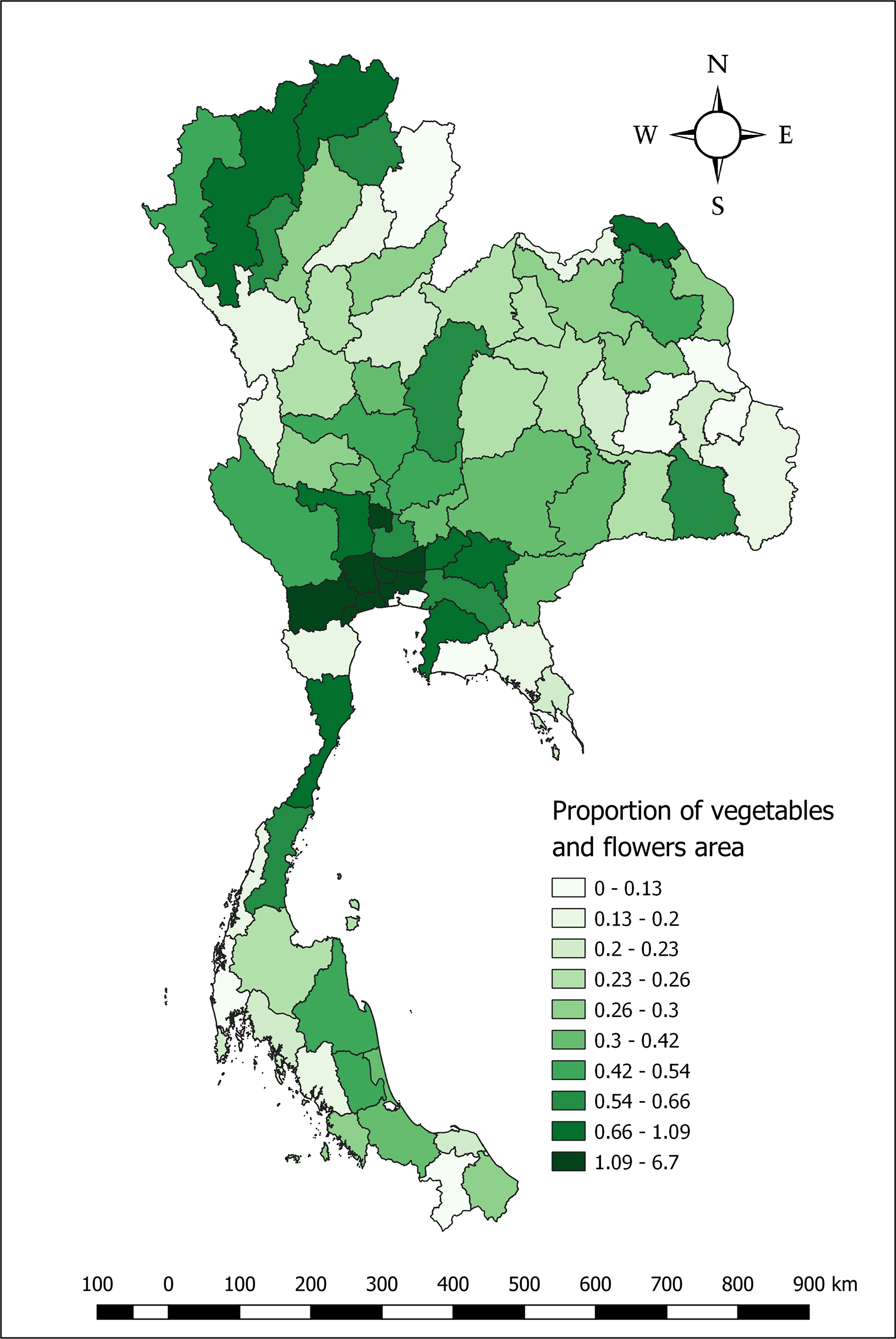
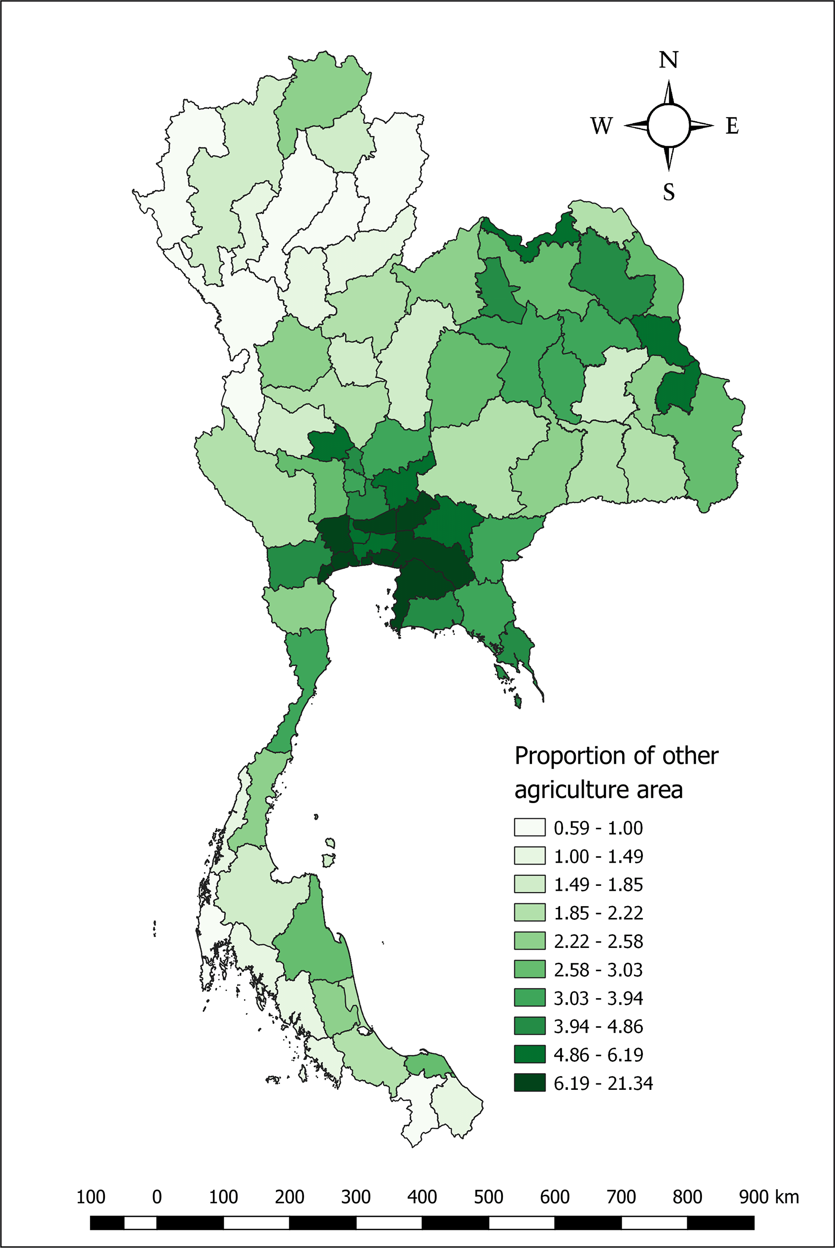
Rice field area was representing the average proportion of rice field when it has been classified as decile. We found that the province with the highest proportion of rice field areas (56.49-70.39%) was the Phichit, Maha Sarakham, Roi Et, Surin, Si Sa Ket, Sing Buri, Ang Thong, and Phra Nakhon Si Ayutthaya provinces (Figure 2). The highest average proportion of field crops areas (22.57-29.44%) were in the Kamphaeng Phet, Nakhon Sawan, Nakhon Ratchasima, Lop Buri, Saraburi, Suphan Buri, Sa Kaeo, and Chon Buri provinces (Figure 3). The highest average proportion of fruit trees and perennial area (44.03-64.65%) were identified in the Samut Songkhram, Rayong, Trat, Chumphon, Krabi, Trang, Pattani, and Narathiwat provinces (Figure 4). In addition, the highest average proportion of vegetable and flower areas (1.09-6.7%) were observed in the Ang Thong, Samut Songkhram, Samut Sakhon, Nakhon Pathom, Pathum Thani, Nonthaburi, Bangkok Metropolis, and Ratchaburi provinces respectively (Figure 5). Furthermore, the highest average proportion of other agriculture areas (6.19-21.34%) were in the Nakhon Nayok, Pathum Thani, Samut Songkhram, Samut Sakhon, Samut Prakan, Nakhon Pathom, Chachoengsao, and Chon Buri provinces (Figure 6).
The Moran’s I indicated clustering patterns of each type of land use density and the average prevalence of pesticide acquired diseases with statistical significance (p-value <0.05). The results illustrated that the proportion of rice field areas had a spatial autocorrelation with the distribution pattern in the same direction as the average prevalence of pesticide-related diseases with Moran’s I: 0.270. The average prevalence of pesticide-related diseases with high value surrounded by high value or risk areas (Hot spot or HH) were observed in eight provinces (Sing Buri, Saraburi, Nakhon Nayok, Phra Nakhon Si Ayutthaya, Samut Prakan, Nakhon Pathom, Pathum Thani, and Nonthaburi provinces). However, low value surrounded by low value (LL) were found in nine provinces (Chiang Mai, Lampang, Chumphon, Ranong, Surat Thani, Phangnga, Phuket, Krabi, and Phatthalung provinces) (Figure 7).
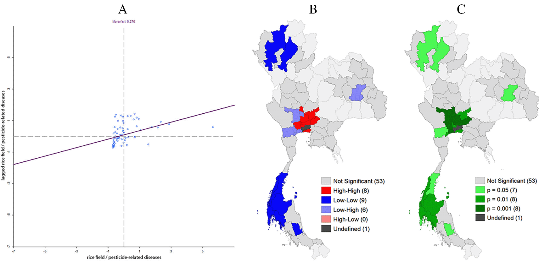
A: Moran’s I scatter plot matrix of the rice field area and the prevalence of pesticide-induced diseases in 2018-2020, Thailand.
B: LISA cluster map of the rice field area and the prevalence of pesticide-induced diseases in 2018-2020, Thailand.
C: LISA significance map (p<0.05) of the rice field area and the prevalence of pesticide-induced diseases in 2018-2020, Thailand.
In addition, the average proportion of field crop areas found that there was a spatial autocorrelation with the distribution pattern in the same direction as the average prevalence of Pesticide associated diseases with the Moran’s I 0.144. Similarly, the average proportion of field crop areas and the average prevalence of pesticide-related diseases with high value surrounded by high value or risk areas (HH) were observed among three provinces (Sing Buri, Prachin Buri, and Rayong provinces). In contrast, low value surrounded by low value (LL) were found in 11 provinces (Chumphon, Ranong, Surat Thani, Nakhon Si Thammarat, Phangnga, Krabi, Trang, Phatthalung, Satun, Songkhla, and Pattani provinces) (Figure 8).
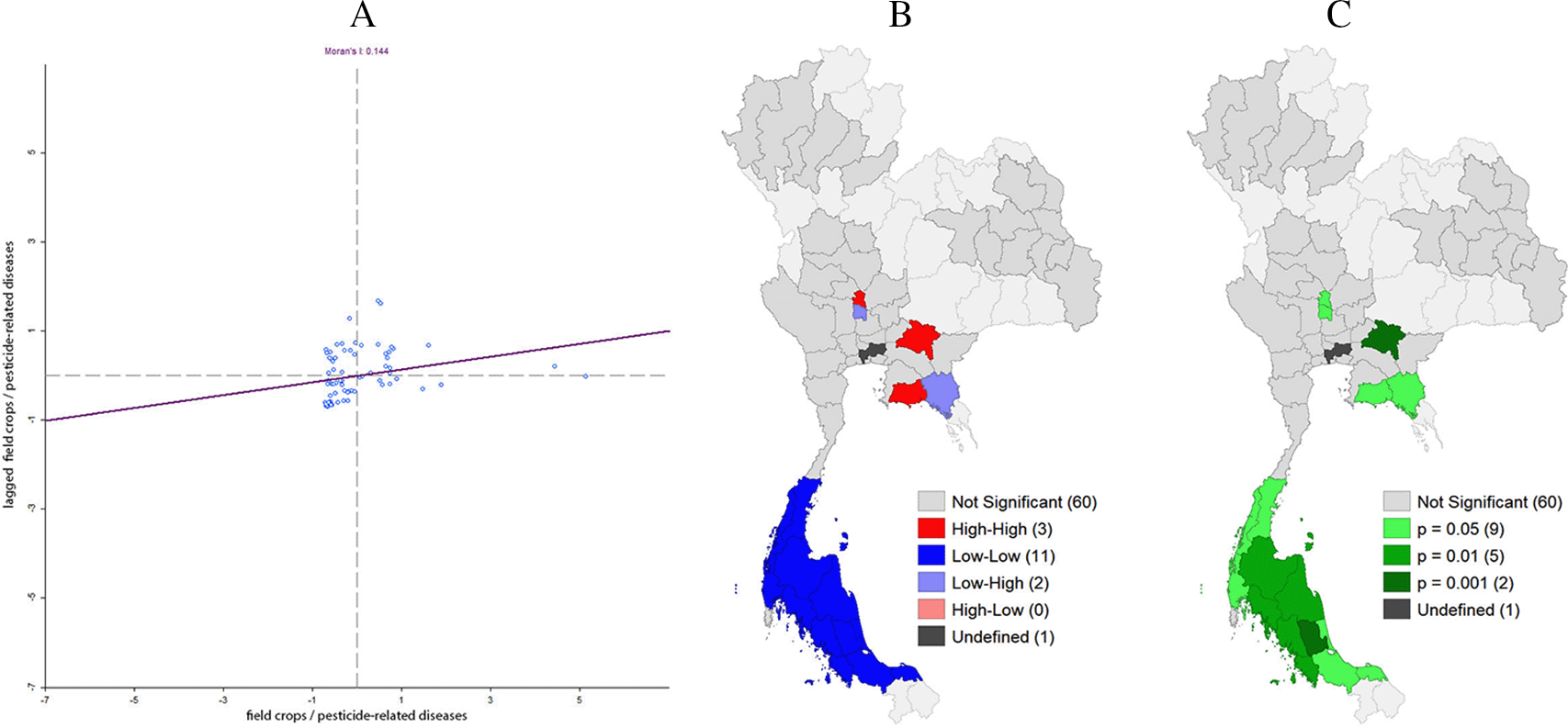
A: Moran’s I scatter plot matrix of the field crops area and the prevalence of pesticide-induced diseases in 2018-2020, Thailand.
B: LISA cluster map of the field crops area and the prevalence of pesticide-induced diseases in 2018-2020, Thailand.
C: LISA significance map (p<0.05) of the field crops area and the prevalence of pesticide-induced diseases in 2018-2020, Thailand.
Simultaneously, the average proportion of fruit tree and perennial areas were found to have spatial autocorrelation which has a distribution pattern in the same direction as the average prevalence of pesticide induced diseases with Moran’s I of 0.606 and high value surrounded by high value or risk areas (HH) were in eight provinces (Phangnga, Phuket, Krabi, Trang, Songkhla, Pattani, Yala, and Narathiwat provinces). Although, low value surrounded by low value (LL) were in found in 12 provinces (Phitsanulok, Phetchabun, Kamphaeng Phet, Phichit, Nakhon Sawan, Uthai Thani, Chai Nat, Lop Buri, Suphan Buri, Sing Buri, Ang Thong, and Phra Nakhon Si Ayutthaya provinces) (Figure 9). Furthermore, the average proportion of vegetable and flower areas in the province found a spatial autocorrelation which has a distribution pattern in the same direction as the average prevalence of pesticide-associated diseases with Moran’s I of 0.135, and found the high value surrounded by high value or risk areas (HH) were among six provinces (Nonthaburi, Pathum Thani, Nakhon Pathom, Samut Sakhon, Samut Songkhram, and Ratchaburi provinces). However, low value surrounded by low value (LL) were in four provinces (Uttaradit, Kalasin, and Yasothon provinces) (Figure 10).
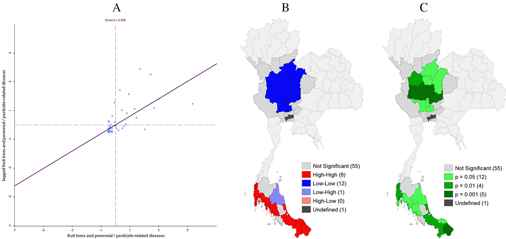
A: Moran’s I scatter plot matrix of the fruit trees and perennial area and the prevalence of pesticide-induced diseases in 2018-2020, Thailand.
B: LISA cluster map of the fruit trees and perennial area and the prevalence of pesticide-induced diseases in 2018-2020, Thailand.
C: LISA significance map (p<0.05) of the fruit trees and perennial area and the prevalence of pesticide-induced diseases in 2018-2020, Thailand.
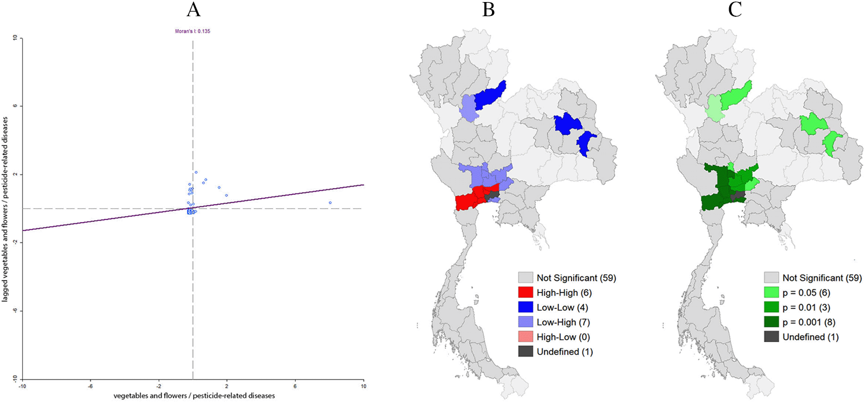
A: Moran’s I scatter plot matrix of the vegetables and flowers area and the prevalence of pesticide-induced diseases in 2018-2020, Thailand.
B: LISA cluster map of the vegetables and flowers area and the prevalence of pesticide-induced diseases in 2018-2020, Thailand.
C: LISA significance map (p<0.05) of the vegetables and flowers area and the prevalence of pesticide-induced diseases in 2018-2020, Thailand.
Finally, we observed that the average proportion of other agriculture areas in the province showed spatial autocorrelation with the distribution pattern in the same direction as the average prevalence of pesticide-induced diseases with Moran’s I of 0.324. This signifies that the high value or risk areas (HH) were in nine provinces (Nonthaburi, Pathum Thani, Nakhon Pathom, Samut Sakhon, Samut Songkhram, Samut Prakan, Nakhon Nayok, Chachoengsao, and Chon Buri provinces). But, low value surrounded by low value (LL) were also in nine provinces (Chiang Mai, Lamphun, Lampang, Phrae, Uttaradit, Sukhothai, Phitsanulok, Kamphaeng Phet, and Phichit provinces) (Figure 11).
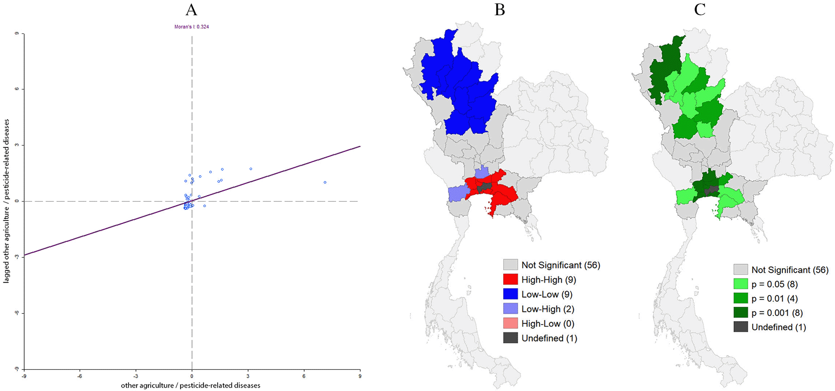
A: Moran’s I scatter plot matrix of other agriculture area and the prevalence of pesticide-induced diseases in 2018-2020, Thailand.
B: LISA cluster map of other agriculture area and the prevalence of pesticide-induced diseases in 2018-2020, Thailand.
C: LISA significance map (p<0.05) of other agriculture area and the prevalence of pesticide-induced diseases in 2018-2020, Thailand.
In our setting, the overall average prevalence of pesticide-induced diseases was 13.17 per 100,000 population in year 2018-2020 in Thailand. However, the prevalence of pesticide-related diseases were lower than the overall study in Thailand for the years 2013 and 2014 which, were 11.62 and 12.25 per 100,000 population respectively in a previous study.20 This might be due to increase pesticide use in recent years.
Our bivariate analysis of Moran’s I and LISA observed the spatial association between type of land-used and prevalence of pesticide induced patients. We found that areas with a higher proportion of rice fields showed a high prevalence of pesticide-induced cases especially in the Centre and Northeast of Thailand. The average proportion of field crop areas on the average prevalence of pesticide acquired cases in Thailand was found only in Central Thailand. The average proportion of fruit trees and perennial areas on the average prevalence of patients related with pesticide pollution was found only in the South of Thailand. And in the Centre of Thailand, the average prevalence of pesticide-induced cases was observed where the average proportion of land use was for the vegetables and flowers only.
Those results might be obtained due to the geographical differences of Thailand with different land-uses. The risks of using chemical pesticides in each area were different as well. For example, the central and northeastern regions of Thailand have a lot of rice fields, which have a higher chance of using the herbicide.21 However, field crop areas and vegetable and flower areas, that were found in the Centre of Thailand have a greater chance of using insecticides.21 Similarly, in the south of Thailand, where people use other chemical pesticides, the fruit tree and perennial areas had a significant association with pesticide pollution.22 Therefore, policy formulations to prevent the use of pesticides, including limiting of pesticides chemical imports should consider for specific areas in order to plan effective control or prevention, such as herbicide and insecticide in the central region and herbicide in the northeast as well as other chemical pesticides in the fruit trees and perennial area in the south. However, this study described an initial assessment by bivariate analysis. Therefore, future studies should control co-variable for analysis to confirm the correct result.
This study allowed us to identify the average prevalence of pesticide-induced disease patients in the provinces of Thailand between 2018-2020. We observed the proportion of rice field areas had a spatial autocorrelation with the distribution pattern in the same direction as the average prevalence of pesticide-related diseases. In addition, areas with a higher proportion of rice fields showed a high prevalence of pesticide-induced cases especially in Central and Northeast Thailand. Therefore, policymakers should focus on the best means to control these cases and provide new policy recommendations for pesticide use for agriculture, especially, in the province with more land-use areas for each type of crop.
| Views | Downloads | |
|---|---|---|
| F1000Research | - | - |
|
PubMed Central
Data from PMC are received and updated monthly.
|
- | - |
Provide sufficient details of any financial or non-financial competing interests to enable users to assess whether your comments might lead a reasonable person to question your impartiality. Consider the following examples, but note that this is not an exhaustive list:
Sign up for content alerts and receive a weekly or monthly email with all newly published articles
Already registered? Sign in
The email address should be the one you originally registered with F1000.
You registered with F1000 via Google, so we cannot reset your password.
To sign in, please click here.
If you still need help with your Google account password, please click here.
You registered with F1000 via Facebook, so we cannot reset your password.
To sign in, please click here.
If you still need help with your Facebook account password, please click here.
If your email address is registered with us, we will email you instructions to reset your password.
If you think you should have received this email but it has not arrived, please check your spam filters and/or contact for further assistance.
Comments on this article Comments (0)