Keywords
Micro-Scale, Transport, Built Environment, Transit-Oriented Community, Transport Supply System, Sustainable Development, Mobility Hub
Micro-Scale, Transport, Built Environment, Transit-Oriented Community, Transport Supply System, Sustainable Development, Mobility Hub
A micro-scale transit built environment (MSTBE) refers to neighbourhood-specific urban design that integrates relevant built environment and transportation indicators. It is the smallest scale since it deals with internal trip capture, relative friction, and the pedestrian environment.1 The authors split the sustainable MSTBE into three scopes: transit-oriented communities (TOCs), sustainably developed transit supply systems, and the mobility hubs (including their zones), all of which are supported by transit frameworks, strategies, solutions, and guidelines (see Figure 1-1).
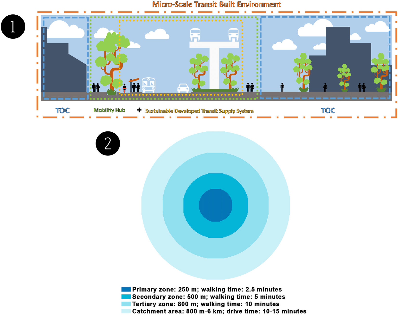
TOCs are walkable, compact, and well-connected neighbourhoods. These neighbourhoods are intended to encourage active transportation by focusing on high-density, mixed-use, and pedestrian-friendly development within the walking distance of frequent transit and utilising mobility management strategies to reduce unnecessary driving. TOCs must be regarded as part of the government's attempt to establish sustainable and innovative means of transportation. The TOC approach aims to aid in developing communities based on transit stations to increase ridership, alleviate traffic congestion, and enhance housing and job opportunities. All of this contributes to the development of entire communities based on solid urban planning and design guidelines. Collaborating to create TOCs has the following primary advantages: the building of complete communities, added value, the creation of a mix of uses, a vibrant public realm, and prominence.2–4
Transit infrastructure and transit services are components of a sustainably developed transit supply system. Transit infrastructure consists of the basic facilities, structures, equipment, technologies, and services that support economic activity and quality of life. It promotes local and regional development by facilitating the flow of goods, connecting production centres with markets, and facilitating people's movements by providing access to work, social opportunities, health and educational facilities, and other services. At the same time, transit services encompass all services (sea, air, land, inland waterways, surveying, and pipelines) that involve the movement of people and products (freight), the rental of carriers with a crew, and related support and auxiliary services – the type and quality of transit services in a neighbourhood influence the establishment of a TOC. Transit service types can be selected based on speed reliability, regardless of infrastructure, and local access attributes are primarily determined by the right-of-way (ROW) type and station or stop spacing.
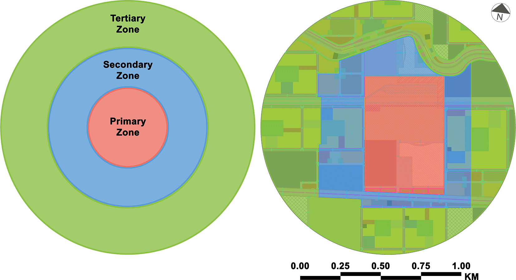
A mobility hub is a multimodal transportation centre that includes major transit stations and their surrounding areas (approximately 10 min/800 m radius), that connect transit, active transportation, and car commutes and that increase the use of shared modes with an emphasis on employment, living, shopping, and/or recreation. This type of hub is frequently seen as a location where new transportation technology and services can be integrated and utilised to improve user experience and increase transportation alternatives for first- and last-mile travel. As the origin, destination, or transfer point for many trips, a mobility hub plays a vital role in the regional transit system.5–7 When planning the process and understanding the needs and potential in each area, it is common practice to split a mobility hub into zones. The four zones are the primary zone, secondary zone, tertiary zone, and catchment area (see Figure 1-2).8
There have recently been statements that Alexandria's ongoing and future transportation projects will be implemented, such as the high-speed train El Ain El Sokhna-Marsa Matrouh, the Alexandria Metro (Abu Qir-Misr Station), Raml Tram Rehabilitation, and the Establishment of Central Stations on the Express Train Track. These statements are on the official website of the Egyptian National Authority for Tunnels.9–12 From the perspective of the authors, accepting these projects is unfeasible because the existing MSTBEs all over Alexandria are unsustainable owing to their lack of scopes: TOCs, sustainably developed transit supply systems, and mobility hubs. Even if there are one or two scopes, the MSTBE will be incomplete.
TOCs are walkable, compact, and well-connected neighbourhoods that are intended to encourage active transportation by focusing on high-density, mixed-use, and pedestrian-friendly development within the walking distance of frequent transit and utilising mobility management strategies to reduce unnecessary driving. Sustainably developed transit supply systems include transit infrastructure and transit services. Mobility hubs are composed of major transit stations and their surrounding areas, and they play an important role in the regional transportation system by serving as the origin, destination, or transfer point for a considerable share of trips. There are no sustainable guidelines to guide the urban design of qualified transit stations and their surroundings, which results in passenger discomfort. Passengers encounter problems in direct and indirect ways, and therefore, passengers are averse to using public transportation and are forced to use private cars. Lastly, each mode of public transportation operates independently, without integration with other transit systems, and does not facilitate passengers' movement from the start to the end of their trips.
This study aimed to establish a sustainable urban design for MSTBE by gathering, studying data and information, and capturing image survey data on the current state of the case (see Data Availability13). It used SWOT analysis to identify and comprehend key issues impacting the urban design of mobility hub zones. The interaction and balance between transportation, land use, and place-making functions were used throughout to meet the aims of the study, including the following:
• Establishing TOCs, which, by design, encourage people to drive less, walk, cycle, and cross more, with a concentration on high-density mixed-use development on a human scale around frequent transit stops and stations.
• Developing an environmentally friendly transportation supply system.
• Creating a mobility hub to merge several forms of transportation into a single focal point.
Our research paper has no relevance to studies involving humans (individuals, human data, or material) or human participants, including personal genomics studies or clinical trials. Therefore, the authors are not concerned with the Helsinki Declaration. Any individual or attendant from any of the institutions visited during this research does not necessitate any protocol or consent from the individual for the use and publication of data in Egypt. Ethical approval must be obtained only when information is not open access.
The “Enhanced MSTBE Phases” methodology was created by the authors to establish a sustainable MSTBE, including documentation, analysis, and development. This methodology was the one that was used for the key elements of the study design used in this research, depending on data collection.
Approval requests: Formal requests were made for information and approvals to the transport institutions to obtain approval to use and share the data and not to face any objections throughout the research operation.
Techniques: The techniques involved looking for documents, maps, manuscripts, and references related to transportation in Alexandria and photographing the case study site by using a digital single-lens reflex (DSLR) camera with a professional camera tripod, a padcaster tripod dolly wheel, and a smartphone with a DJI Osmo Mobile 3 Gimbal for the smartphone.
Analysis Method: SWOT analysis was used as a tool to determine the strengths, weaknesses, opportunities, and threats of the case study site.
The study focused on the MSTBE in Alexandria and highlighted the Muharram Bek El Mowkaf El Gedid Mobility Hub (MBMH) and the 800 m radius surrounding it as the case study. The authors established a proposal for the MBMH and the 800 m radius surrounding it. This study used the “Enhanced MSTBE Phases” methodology, which was created by the authors, to establish a sustainable MSTBE, including documentation, analysis, and development.
Data collection depended completely on the documentation phase, which was the first phase where data and information were collected. From this phase, the authors were able to complete the next phases. The first phase was documentation, which included researching and gathering information and data on the current state of the case. This phase was divided into four aspects, including visits, photography, drawings, and TV shows. The second phase included conducting an overall analysis of the data collected in the first phase, utilising SWOT analysis. Depending on the two prior phases, the third phase came with a proposal for the case study.
As mentioned earlier, this phase was divided into four aspects:
Visiting relevant transport institutions: Visits were made to the General Authority for Passenger Transport in Alexandria, Public Authority for Planning Transport Projects, National Railway Authority of Egypt, Ministry of Transportation, and Directorate of Housing and Utilities–Alexandria. Appointments were made:
• To view documents, maps, manuscripts, and references related to transportation in Alexandria, such as the Strategic General Urban Plans, which were prepared by the Egyptian General Organisation of Physical Planning (GOPP) in collaboration with other authorised accredited local and foreign organisations: the Maclean Plan 1921 and General Plan (GP) 1959, GP 2005, GP 2017, GP 2025, GP 2032, and GP 2050 (the authors have collected the plans into two figures; see Data Availability,13 “Strategic General Urban Plans (1).jpg” and “Strategic General Urban Plans (2).jpg”).
• To have some available public notes for the transit projects in Alexandria that may be helpful in the study, such as titles of ongoing projects and whether they are on schedule i.e., the high-speed train El Ain El Sokhna-Marsa Matrouh, the Alexandria Metro (Abu Qir-Misr Station), Raml Tram Rehabilitation, and the Establishment of Central Stations on the Express Train Track, as the Egyptian National Authority for Tunnels announced about them; the Alexandria urban transport study is financed by the neighbourhood investment facility from the European Union and managed by the French Development Agency (Agence Française De Développement); the Egyptian Government commissioned EGIS rail, a French advisory office, to prepare a long-term scenario for the Alexandria governorate strategic plan for urban transportation consistent with urban planning for the city; and a partnership between SYSTRA, AECOM, Orascom Construction SAE, The Arab Contractors, Siemens Mobility, and other companies with the Egyptian ministries to consult, design, install, commission, and maintain the systems for the projects.
• To facilitate the operation of capturing image survey data on the current state needed for the case study.
Prior to the visits, the authors submitted “Formal Requests for Information and Approval”, signed by the Vice Dean for Graduate Studies and Research, Prof. Sahar Mahmoud Al-Arnaouti, and stamped by the Faculty of Fine Arts, to the transport institutions and obtained approval to use and share the data.
For the copies and translation of the formal requests for information and approval, see Data Availability13.
Capturing image survey data: The authors used the following photography and panoramic photography tools to acquire image survey data: (1) a DSLR camera with a professional camera tripod, (2) a padcaster tripod dolly wheel, and (3) a smartphone with a DJI Osmo Mobile 3 Gimbal for the smartphone to capture image survey data on the current state of the case study (see Data Availability,13 “00 Capturing Image Survey Data Tools.jpg”, “01 Primary Zone.jpg”, “02 Secondary Zone.jpg”, and “03 Tertiary Zone.jpg”).
Overlaying, tracing, drawing, and presenting: The authors used the maps obtained from the institutional archives (the authors have collected the plans into two figures; see Data Availability,13 “Strategic General Urban Plans (1).jpg” and “Strategic General Urban Plans (2).jpg”) and the exported images from Google Earth Pro (see the software availability statement for alternatives) to draw the new Alexandria Transit Map by overlaying and tracing with Autodesk AutoCAD (see the software availability statement for alternatives). Then, the authors cropped the case study zone from it and presented the case study zone using Adobe Photoshop (see the software availability statement for alternatives).
Transcribing announcement on TV shows: On the “Al Hekaya” TV talk show, presenter Amr Adeeb and Kamel El-Wazir, the minister of transport of Egypt, announced official transportation news about the transit developments in Egypt and Alexandria (see Data Availability,13 “Official Transportation News through the Media.pdf” provides descriptions of the news).
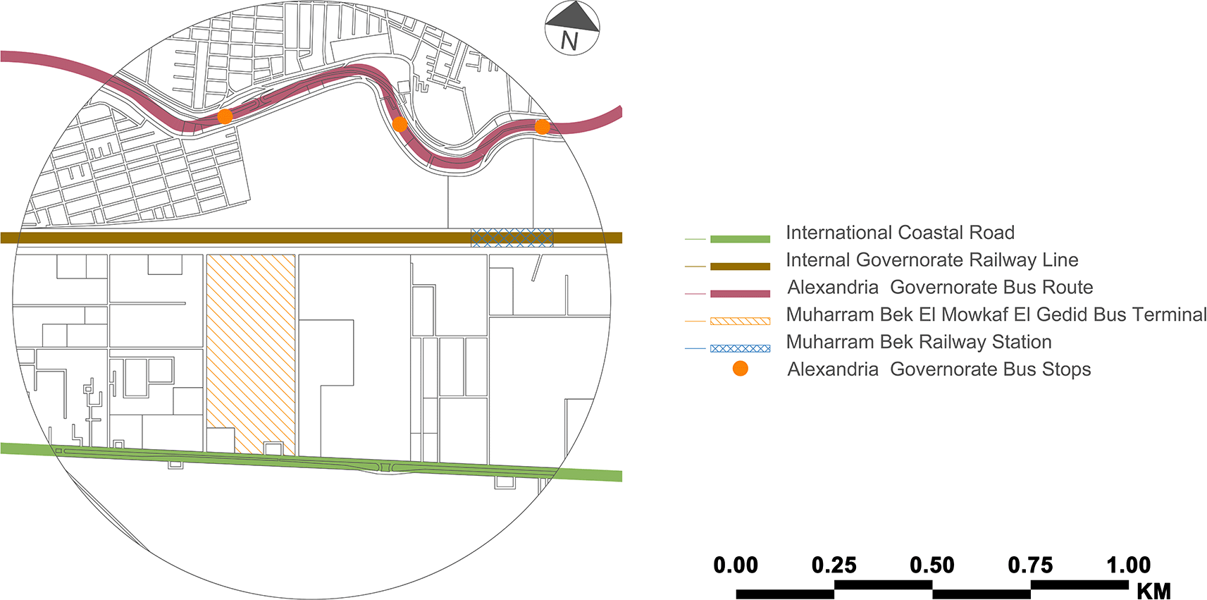
After conducting comprehensive research and data collection, the authors selected the MBMH as the case study zone from among 23 mobility hubs indicated on the new Alexandria Transit Map. The case study zone is located in Alexandria's core area and includes the 800 m radius surrounding the Muharram Bek El Mowkaf El Gedid Bus Terminal. Before the 1952 revolution, the Muharram Bek neighbourhood was considered an elite neighbourhood, with mansions and villas dominating the area. In accordance with GP 2032, an electric high-speed rail terminal will be constructed in front of the Muharram Bek El Mowkaf El Gedid Bus Terminal. Table 1 presents the current profile for the case study zone.
The Muharram Bek El Mowkaf El Gedid Bus Terminal is the new bus terminal for regional and national bus connections located in Alexandria's Muharram Bek area. Construction of it began in 2001 and was completed in 2003. It is operated by the National Company for Road Construction and Development and serves as the primary departure and arrival point for passengers travelling by land to and from Alexandria. It was considered an alternative to the old bus stop at the Sidi Gaber Train Station before all buses and taxis for the governorates were relocated to the present location. Public transportation runs across the case study zone (see Figure 2). However, there is no integration between two or more public transportation modes. Arriving passengers could use the train, but since the current Muharram Bek railway station is more than 1 kilometre distant, they cannot. An extra stop along the new suburban train line would be beneficial, and getting to the Misr Station Train Station is also difficult. Although the Misr Station is approximately 2 kilometres distant, the railway line prevents pedestrian access to the city centre.
This figure is the authors’ own work.
There is currently no mobility hub in the case study. However, the authors created a radius walking distance map to identify and analyse the mobility hub zones (see Figure 3-1). The following table (Table 2) shows the SWOT analysis for each mobility hub zone (see Figure 3-2). SWOT analysis is used to investigate the current and initial conditions of the planned hub site and its surroundings. Analyse existing transport networks, including street connections, cycling, pedestrian infrastructure, and public transport. This review included land use, urban form, and neighbourhood character to fully capture the context of the site. Redevelopment opportunities on and around the site were analysed to understand the potential of mobility hubs to support transit-oriented development. Finally, the site's constraints and opportunities are discussed to determine which elements of the mobility hub are best suited to the site's current issues and build on its strengths. In addition, the view of documents, maps, manuscripts, and references related to transportation in Alexandria, notes taken from visiting relevant transport institutions, and El-Wazir's explanation of official statements from transcribing announcements on TV shows helped the authors build the outline description of the current situation for the SWOT analysis.
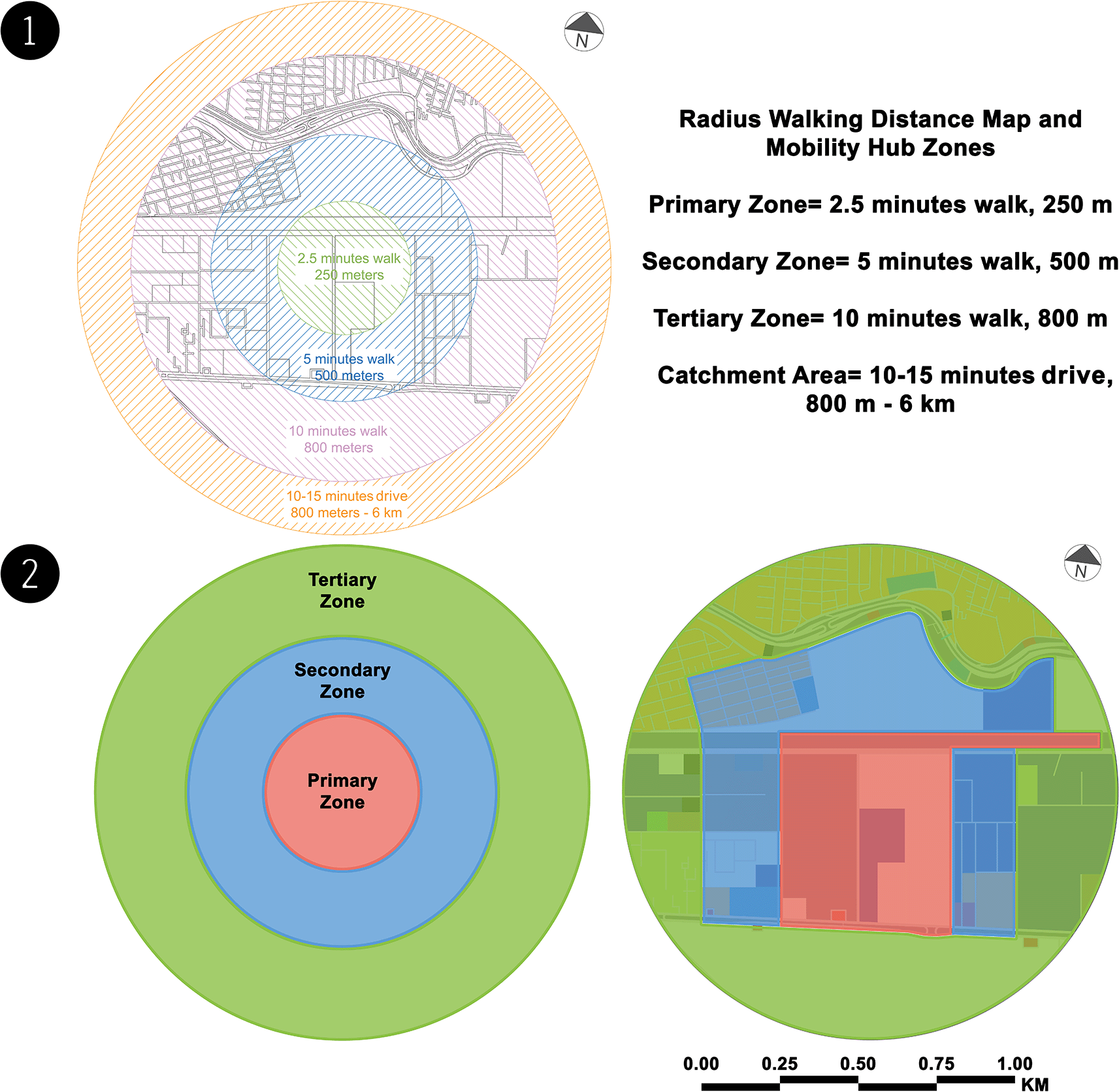
This figure is the authors’ own work. (2) Mobility hub zones – case study zone (present). This figure is the authors’ own work.
| SWOT | Primary Zone | Secondary Zone | Tertiary Zone |
|---|---|---|---|
| Strengths |
|
| |
| Weaknesses |
|
|
|
| Opportunities |
|
| There are development services, i.e., petrol stations, car service centres and a supermarket |
| Threats | There is no provision to guarantee the safety of people crossing the train track from mixed-use land | Pedestrians do not generally use bridges except a few times due to the many stairs on the bridges; pedestrians jump over concrete barriers to pass from one side to the other, often exposing passers-by to danger; some neighbourhood residents made a small ladder bypassing by jumping or using bridges |
From the authors' viewpoint, the MBMH will become a mixed-use attraction within the city. The land uses on both sides of the transit corridors will create a distinctive mobility hub location with appealing streetscapes, reinforce the built form and open space transitions to new residential uses. The neighbourhood's developed form will be mainly mid-rise. It will be supported by a mixed-use development optimising connections and views. The authors utilised the prior studies to export a proposal map to create a rich MSTBE. The authors worked on developing certain multi-dimensional aspects, such as land use, the built form, and open space and circulation, so that they could offer a proposal, as presented in the table below (Table 3). Following the table (Table 4), the authors created the proposal profile for the MBMH.
| Land Use | Built Form | Open Space & Circulation |
|---|---|---|
|
|
|
| Item | Description |
|---|---|
| Mobility Hub's Name | Muharram Bek El Mowkaf El Gedid |
| Context | Suburban mixed:
|
| Transport Function | Destination |
| Type | Anchor |
| Scale | City centre mobility hub |
| Infrastructure – Lines & Routes |
|
| Infrastructure – Others |
|
| Transit Modes |
|
| Related Mobility Components |
|
| Non-Mobility and Urban Realm Improvement Mobility Components | |
| Park & Ride | The authors propose relocating the Muharram Bek Train Station to the mobility hub site, accompanying the park and ride |
The authors dispersed land uses throughout the case study based on the demands of each mobility hub zone (see Figure 4). In the primary zone, the authors focused on utilising this zone on the MBMH and its amenities on both sides of the transit corridor to offer a walkable environment with direct, weather-protected access. Secondary zone utilisation is mostly mixed-use development along major transit corridors with enhanced transit services and visible and physical links to the mobility hub. Finally, mid-rise buildings are primarily clustered around transit services in the tertiary zone, with the greatest height and density along the railroad track. The needed services are provided within and around the buildings, considering the heights of residential buildings and open spaces. Implementing living streets by installing cycle infrastructure and creating pedestrian-friendly streets along transit corridors and within residential buildings creates safe and direct connections across the transit corridors.
This figure is the authors’ own work.
The authors estimated the exact percentages of the land uses for each mobility hub zone in the case study at the current and proposed states (see Figure 5) and compared them to ensure that the balance distribution is suitable and balanced in the table below (Table 5).
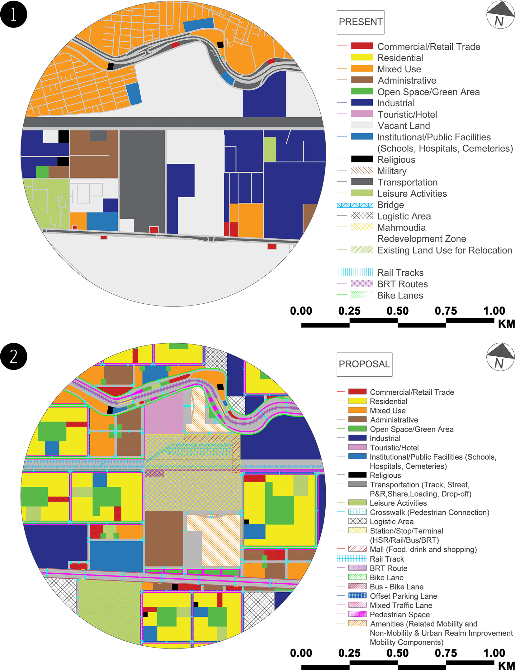
This figure is the authors’ own work. (2) Land uses map – case study zone (proposal). This figure is the authors’ own work.
The proposal includes the following:
• The new development will provide a direct pedestrian connection to the MBMH.
• The Muharram Bek neighbourhood will be framed by mid-rise construction, providing a dynamic cityscape that transitions to stable residential sections. Mid-rise buildings will provide new areas to live, work, and shop with easy access to public transportation.
• An enhanced streetscape and bike lanes will be installed along with the transit modes.
• Neighbouring residential communities will be protected and enhanced.
• The Muharram Bek El Mowkaf El Gedid Bus Terminal will be integrated with the Muharram Bek Railway Station (after relocation), the Alexandria High-Speed Rail Terminal, and a compact urban street network that includes the Bowalino BRT Stop, Alexandria High-Speed Rail Station BRT Stop, Muharram Bek El Mowkaf El Gedid BRT Stop, and Alexandria Governorate Bus Stops.
• Public and semi-public open spaces will be included in the new development.
• The new mixed-use development will seamlessly link with the multimodal transit hub, creating new housing and employment opportunities.
• In conjunction with new development opportunities, a new bicycle and pedestrian-friendly street character for Muharram Bek will be established.
• The proposed streetscape upgrades in the Muharram Bek neighbourhood will connect all streets with new development.
Transportation has changed dramatically in the last decade. Demographic changes, increased urbanisation, and changes in employment types and arrangements have put additional demand on existing transportation and transit networks. Alexandria must be ready to accept ongoing/future transportation developments that will complement local transit. This study was concerned with employing new concepts to address community concerns and providing a proposal to optimise the present aspects of the topic under investigation with appropriate adjustments and enhancements.
The case study is documented, analysed, and developed via the implementation of the Enhanced MSTBE Phases. The Enhanced MSTBE Phases methodology facilitates urban design research by developing MSTBEs to be sustainable based on researching, gathering data and information, and capturing image survey data on the current state of the case study. The SWOT analysis of mobility hub zones provides a platform for analysing internal potential and weaknesses as well as future external opportunities and threats. It considers all positive and negative factors that influence success within and outside the case study. Analysis of the MSTBE in which the authors work assists in anticipating changing trends and applying them to long-term sustainable decision-making.
This research uses the MBMH as a case study as a starting point for applying Enhanced MSTBE Phases in Alexandria, Egypt. The Enhanced MSTBE Phases methodology develops the case study zone to be a sustainable MSTBE with multi-dimensional aspects such as land use, the built form, open space, and circulation within the 800 m radius of the Muharram Bek El Mowkaf El Gedid Bus Terminal. As a result, a long-term sustainable MSTBE acts as a catalyst for future implications influencing meso-scale and macro-scale transit built environments.
• Google Earth Pro free alternative: OpenStreetMap.
• Autodesk AutoCAD free alternatives: FreeCAD and LibreCAD (2D).
| Views | Downloads | |
|---|---|---|
| F1000Research | - | - |
|
PubMed Central
Data from PMC are received and updated monthly.
|
- | - |
Provide sufficient details of any financial or non-financial competing interests to enable users to assess whether your comments might lead a reasonable person to question your impartiality. Consider the following examples, but note that this is not an exhaustive list:
Sign up for content alerts and receive a weekly or monthly email with all newly published articles
Already registered? Sign in
The email address should be the one you originally registered with F1000.
You registered with F1000 via Google, so we cannot reset your password.
To sign in, please click here.
If you still need help with your Google account password, please click here.
You registered with F1000 via Facebook, so we cannot reset your password.
To sign in, please click here.
If you still need help with your Facebook account password, please click here.
If your email address is registered with us, we will email you instructions to reset your password.
If you think you should have received this email but it has not arrived, please check your spam filters and/or contact for further assistance.
Comments on this article Comments (0)