Keywords
Primary health care, emergencies, geographical standard, demographic standard, GIS, Coverage
This article is included in the Health Services gateway.
Primary health care, emergencies, geographical standard, demographic standard, GIS, Coverage
This new version of the article includes several improvements and clarifications compared to the earlier version. The methods section has been made clearer by adding more explanation about how the GIS analysis was done, including road network preparation, delay time calculation, and how final travel time was computed. More details were also added to explain how the network dataset was built and how service areas were analyzed.
Several figures, tables, and descriptions have been updated to make the results easier to understand, especially the maps showing PHC coverage, population density, and underserved areas. The demographic analysis was also clarified to show more clearly how the number of required PHC centers was calculated.
The discussion section has been strengthened to better explain what the findings mean for healthcare planning and emergency preparedness. The recommendations have been simplified and made more practical for policymakers.
Overall, this version provides clearer explanations, improved analysis, and more useful conclusions, making the study easier to follow and more informative.
See the authors' detailed response to the review by Ayed Taran
See the authors' detailed response to the review by Jianwei Li
See the authors' detailed response to the review by Pankaj Roy
See the authors' detailed response to the review by Hanifa Denny
The pre-disaster phase of the disaster management (DM) process is based on examining the current readiness of facilities and services related to disaster risk reduction and identifying and addressing deficiencies and weaknesses for providing the needs and requirements for the success of the DM process.1 The spatial evaluation process for the sites of services and facilities needed for DM examines readiness in the study area using geographic information system (GIS) techniques and spatial analysis.2–4
Geographical standards (coverage distance) and demographic standards show the capabilities of primary health center facilities to cover the largest area of the study area and the service area. In addition, we analyze the population’s suitability with the number of facilities available in the study area to find out if it is sufficient to provide services to the entire community according to the standards required.5–8
Primary health care (PHC) is a crucial component of health systems and communities’ social and economic development.9–11 PHC is responsible for providing health services and responding to emergencies at each sub-region level.11–16 Sleman District was chosen as the study area because it has a high population density, mixed urban and rural areas, and a high disaster-risk level. There are 26 centers in Sleman District, Indonesia, distributed over 17 sub-regions.12
The study utilized demographic and geographic Standards as variables, gathering data from the District Health Office. It adhered to the Ministry of Health’s regulations to assess their applicability within the study area.
The study was conducted in Sleman District, Yogyakarta City, Indonesia, which comprises 26 Primary Health Care (PHC) centers distributed across 17 sub-regions. Sleman District has the highest disaster risk index in Yogyakarta, with a score of 97.17 This study utilized ArcGIS 10.5 to analyze the distribution and accessibility of PHC facilities based on demographic and geographic standards, aiming to identify shortages, assess needs, and propose solutions and recommendations.18–21
The GIS-based analytical approaches employed in this study depend on the availability of spatial and non-spatial data.22–24 According to the geographical standard, each sub-district should have one PHC, and urban facilities should have a service scope within specific distances: 5 km for hospitals, 2.5 km for schools, and 2 km for markets. Non-spatial data, such as population demographics, were also considered to estimate healthcare demand.25,26
Furthermore, the study utilized statistical data to measure the need for new PHC centers based on the population data. The Ministry of Health set the standard where each PHC has to provide services for 20,000 people.27
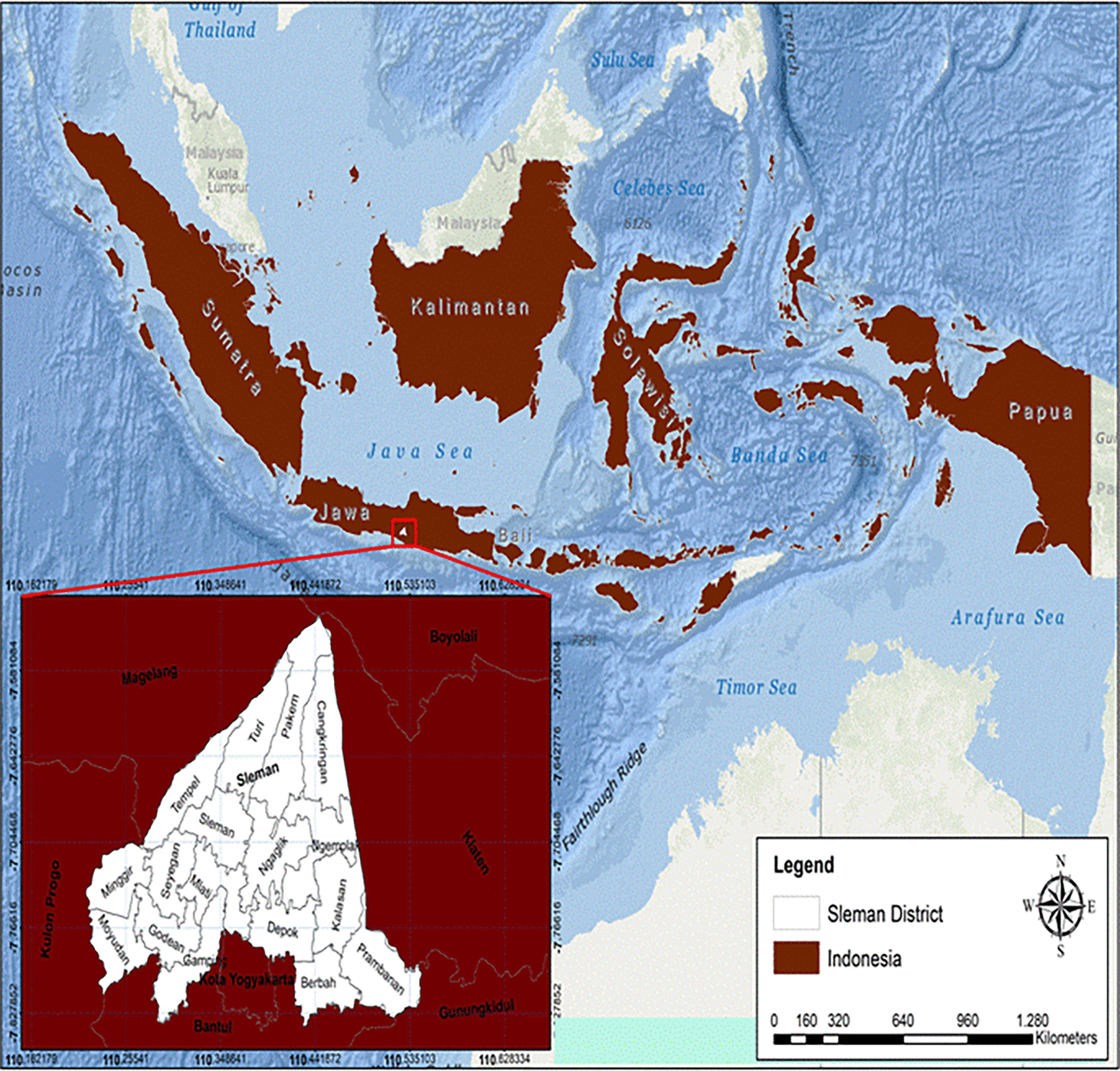
Sleman District is located between 110° 13′ 00″ to 110° 33′ 00″ east longitude and 7° 34′ 51″ to 7° 47′ 03″ south latitude (see Figure 1).
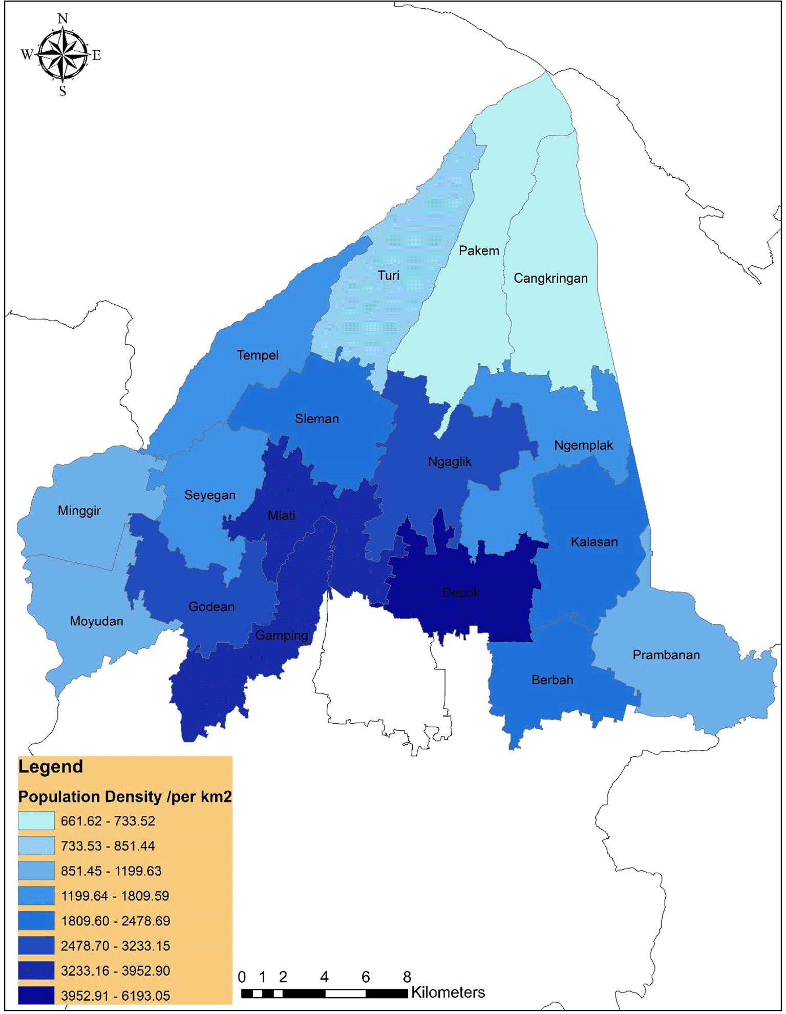
Sleman had a population of 1,206,714, comprising 608,968 males and 597,746 females, within an area of 574.82 km2. The population density was 2,099 people per km2. Notably dense districts include Depok (5,359 people per km2), Mlati (4,049 people per km2), Gamping (3,771 people per km2), and Ngaglik (3,194 people per km2) in 2018.28
Figure 2 shows the population density distribution across Sleman District. High-density areas in the central and southern sub-districts indicate greater service demand, supporting the demographic finding that 41 additional PHCs are needed.
Proximity Analysis: Assessed the accessibility of PHC facilities by measuring distances or travel times from specific locations, considering transportation networks and road conditions to determine ease of access during emergencies.
Spatial overlay: Combined spatial data layers to identify relationships and patterns, such as overlaying facility locations with demographic data to pinpoint areas with a critical need for primary care. This overlay identified gaps by linking population data to service coverage zones, helping to pinpoint critical need areas. Additional overlays for schools and markets (within 2.5 km and 2 km, respectively) were also applied to measure secondary accessibility standards.
Network analysis: Optimized routes and travel times using transportation networks, aiding in the identification of efficient emergency service routes and areas requiring improved infrastructure or additional facilities. Routes were calculated considering road types, traffic patterns, and transportation networks, which enabled the identification of underserved areas and assessment of infrastructure improvement needs.29,30
This study improves travel-time estimation by adding delay time into the ArcGIS network analysis ( Figure 3). Previous calculations only used the road length and speed, which often produced inaccurate results during emergencies.
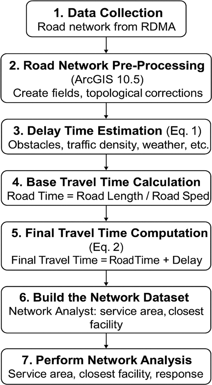
Delay time is calculated using Equation (1). It represents the additional time caused by obstacles, traffic, and road conditions.
The base travel time is calculated using Equation (2), and both values are combined to obtain the final travel time.
The GIS network analysis used Sleman’s road network data obtained from the Regional Disaster Management Agency (RDMA). This road network forms the basis for modelling disaster-response accessibility. Roads in Indonesia are classified by speed and status—National (100 km/h), Provincial (80 km/h), City (50 km/h), and Other Roads (30 km/h)—following national transport guidelines.
The road database was processed in ArcGIS 10.5 to correct topological errors such as gaps and breaks. Additional attribute fields were created, including road type, direction, speed, length, delay time, travel time, and road condition. These parameters support network restrictions and determine how each road segment contributes to travel time, service area, and emergency response analysis. Road direction was classified as one-way or two-way, while road condition was categorized as very good, good, bad, or very bad.
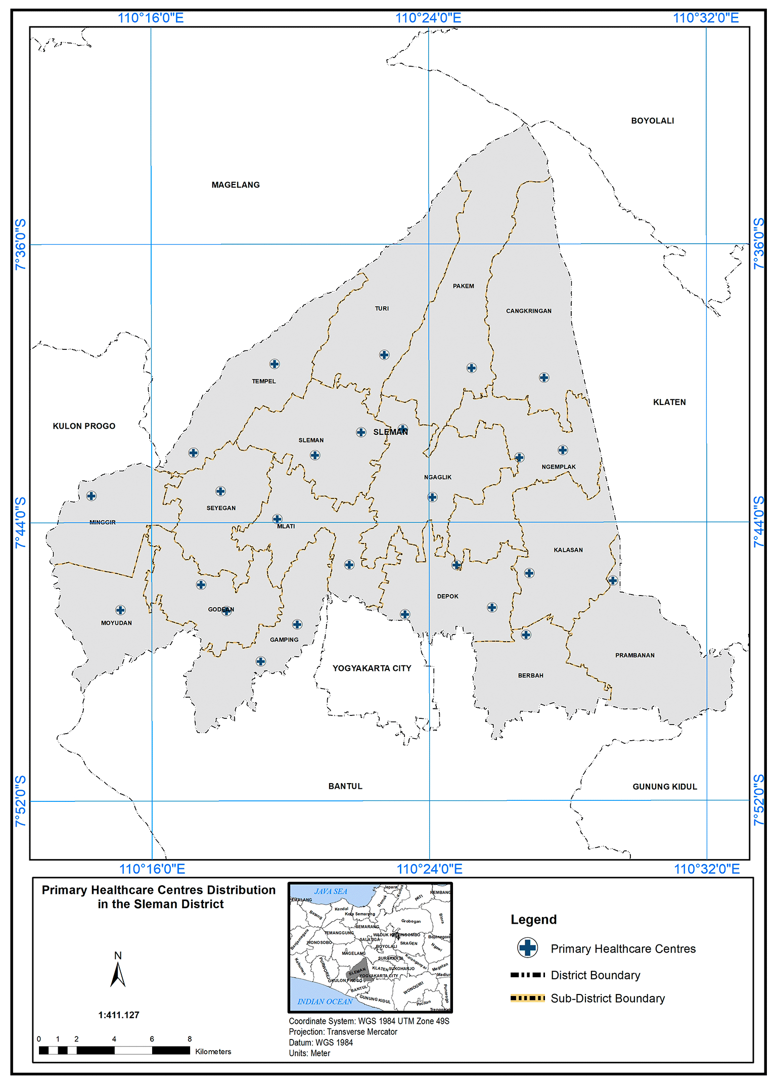
The correctness of facilities’ locations were verified through maps using Google Earth and WorldWindEarthExplorer. Using the ArcGIS 10.5 program and Arc Analysis tools, the study area is derived based on arial images, identified by comparing it with the arial images obtained from Indonesian Disaster Management Agency. The extracted data sets were then transferred to Microsoft Excel 2013, using the network analysis in Arc GIS 10.5 (open source alternative: QGIS) to analyze and determine the scope of service of PHC. Spatial analysis of the location regarding PHC needed in the study area depended on geographical standard and demographic standards. By applying these standards, we can inquire about PHC capabilities to cover the study field and the service area that could be accessed. In addition to analyzing the population’s suitability with the number of PHCs available in the study area, is it sufficient to provide primary healthcare services to all, at the time and standard required? The analysis started by obtaining the map of 26 PHC centres distributed over 17 sub-regions as shown in Figure 4.
According to the geographical standard, each sub-district must have one PHC and urban facilities, including a scope of service within 5 km, a school within 2.5 km, a market within 2 km, and a hospital within 5 km.31 The service area of PHCs in the study area, based on these geographical standards, is illustrated below:
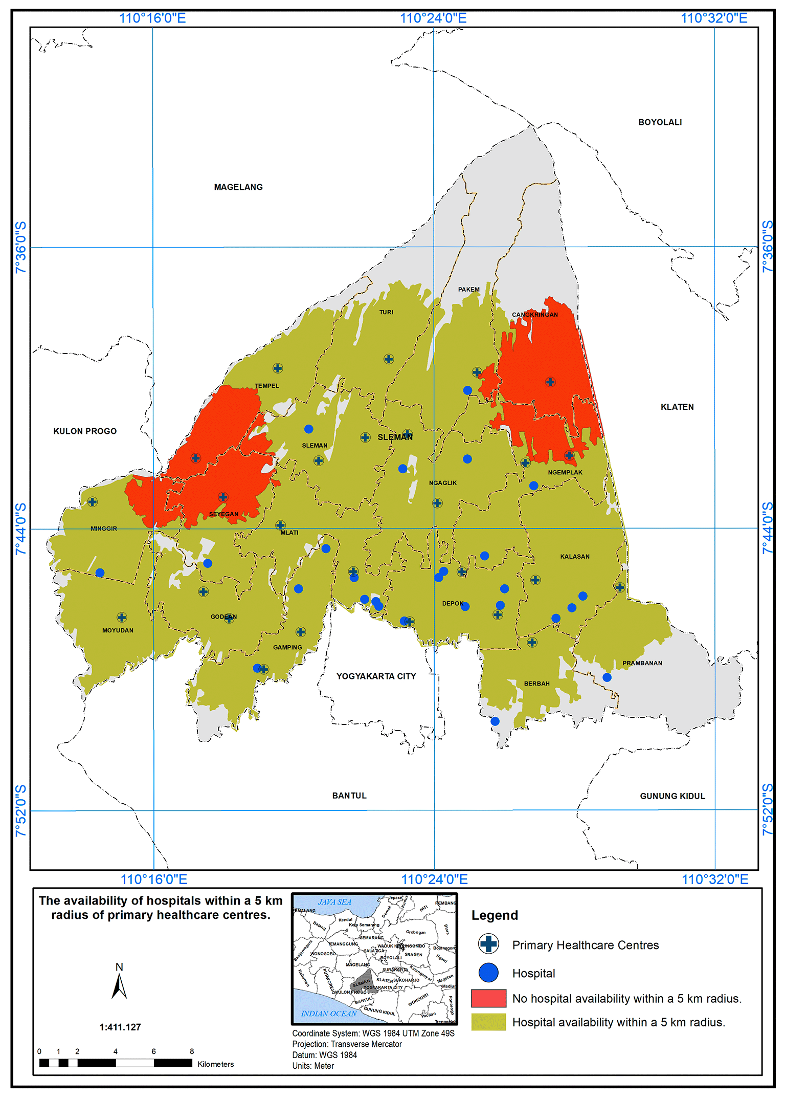
The PHC service areas in the study area are defined by a 5 km radius from hospitals. Figure 5 shows the availability of hospitals within this radius. It was found that 24 health centers met the specified standard in the presence of a hospital (represented in green), while two health centers did not meet the standard (represented in red).
The PHC service area based on a 5 km radius is further detailed in Figure 6. According to the Indonesian Ministry of Health standards, health centers are required to provide services within a 5 km distance. The 5 km radius for healthcare service coverage is chosen to enhance accessibility and equity, ensuring patients can reach healthcare within a manageable distance, especially in rural and semi-urban areas (Regulation of the Minister of Health of the Republic of Indonesia Number 43 Year 2019 Concerning Public Health Centers, 2019).
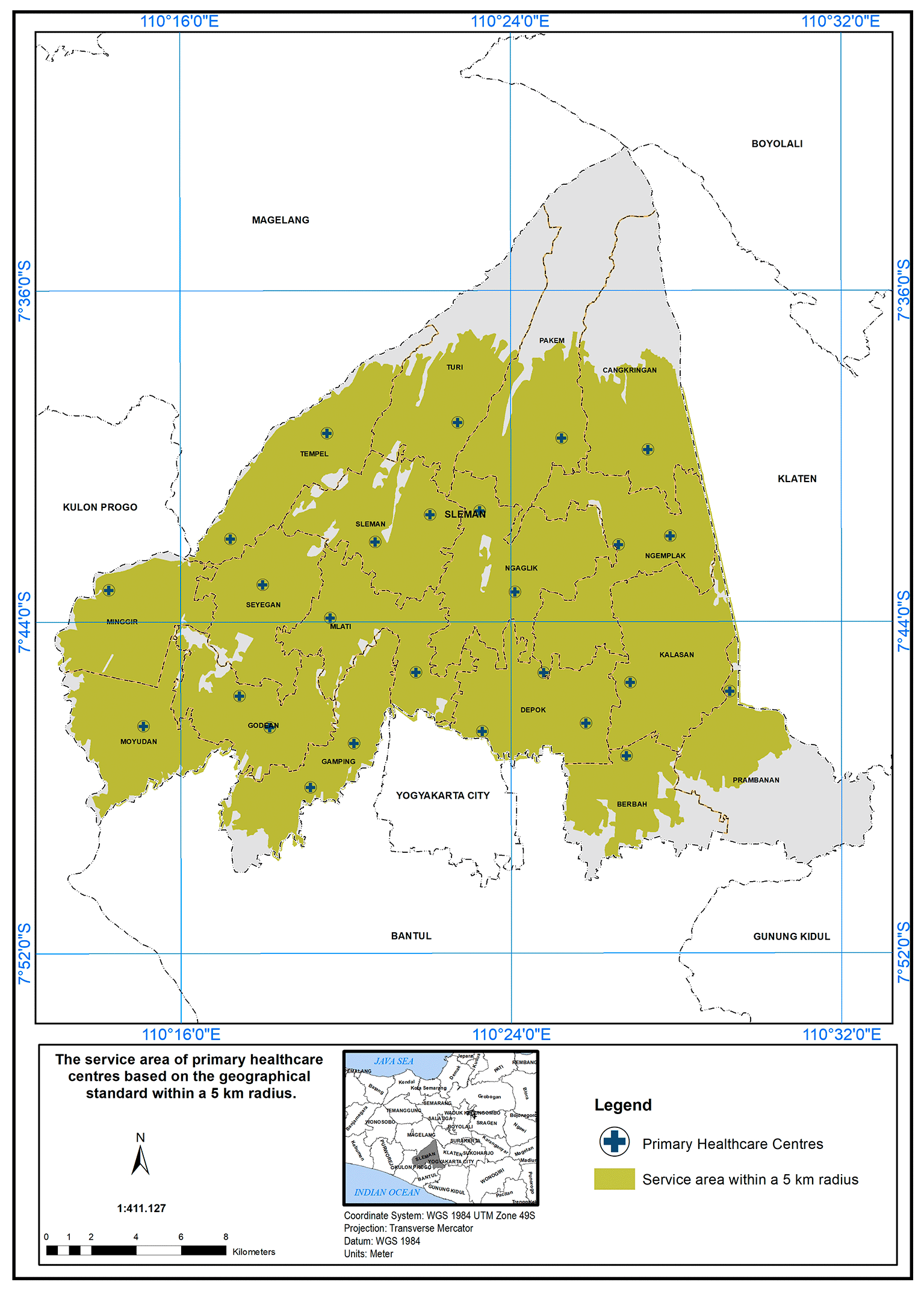
In Sleman District, health centers cover an area of 454.10 km2 out of 574.25 km2, serving approximately 79% of the study area. The unserved area totals 120.15 km2, primarily in the northern (Cangkringan, Pakem, Turi, Tempel) and southern (Prambanan, Berbah, Gamping) districts. Detailed coverage for each district is provided below:
• Cangkringan District: One PHC covers 24.24 km2 out of 44.72 km2 (45% unserved).
• Pakem District: One PHC covers 25.98 km2 out of 52.70 km2 (50.7% unserved).
• Turi District: One PHC covers 22.90 km2 out of 40.50 km2 (43.4% unserved).
• Tempel District: Two PHCs cover 28.45 km2 out of 32.33 km2 (12% unserved).
• Prambanan District: One PHC covers 14.25 km2 out of 40.62 km2 (64.9% unserved).
• Berbah District: One PHC covers 17.0 km2 out of 25.85 km2 (24.2% unserved).
In conclusion, the study area has a service coverage deficiency of 21%. This highlights the need for additional primary healthcare centers (PHCs) in districts that face shortages. These districts have high population densities and are also located in close proximity to natural disaster sources, such as volcanoes, floods, and landslides. Inadequate PHC coverage can lead to serious health outcomes, including delayed treatment, increased cases of preventable diseases, and higher maternal and child mortality rates. During disasters or emergencies, limited access to healthcare may also result in greater vulnerability and poorer recovery among affected populations.
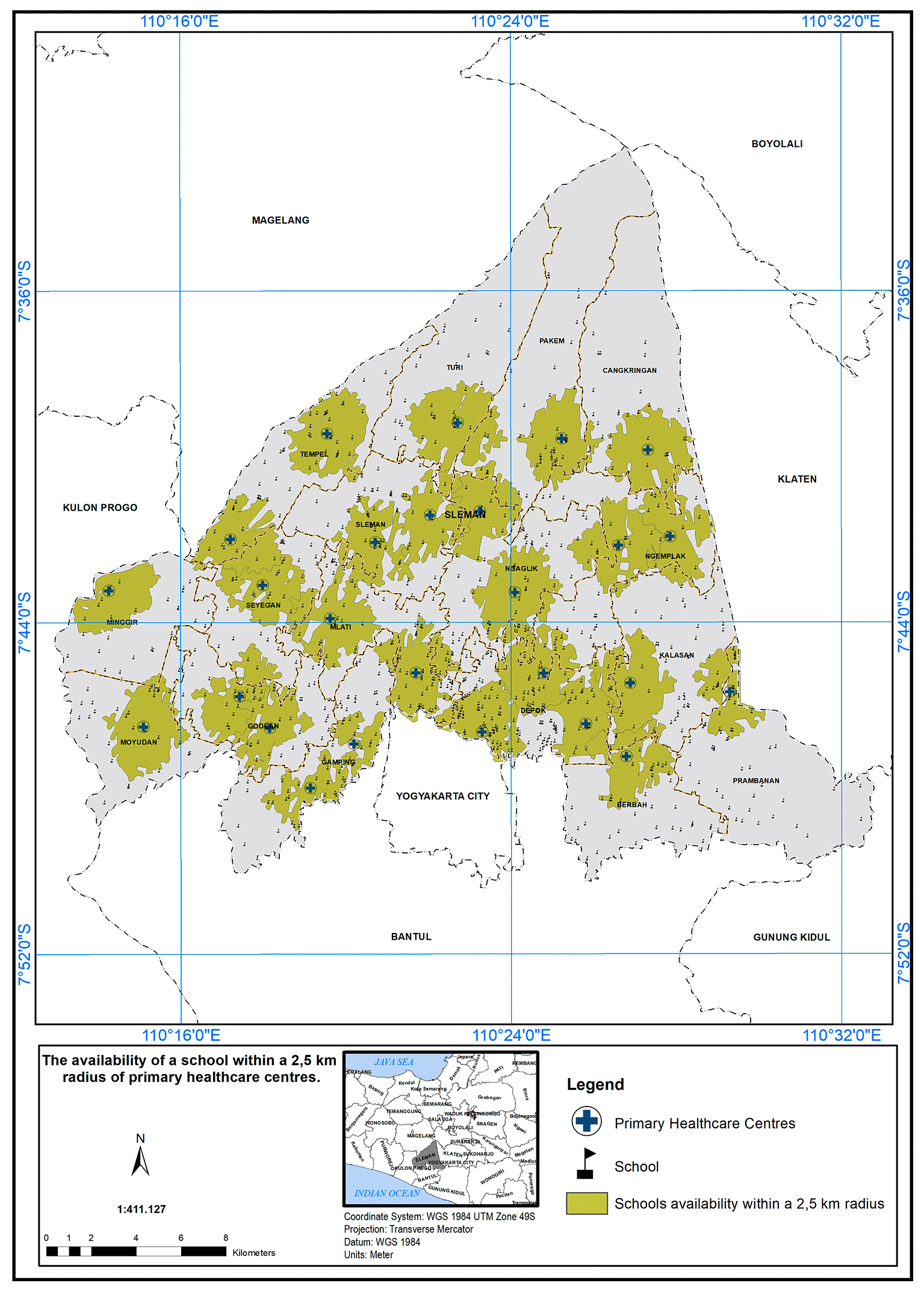
The service area of the PHC center is defined as a 2.5 km radius from the schools. Figure 7 illustrates the availability of schools within this 2.5 km radius. A service scope within 2.5 km of the primary care centers has been implemented. In Figure 7, 26 PHC centers met the specified standard in the presence of a school, indicated by the green color.
The service area based on a 2 km radius from markets is shown in Figure 8. Out of 26 PHCs, 23 met the standard (indicated in green), while three did not (indicated in red). Three PHC centers did not meet the specified standard in the presence of a market, indicated by the red color.
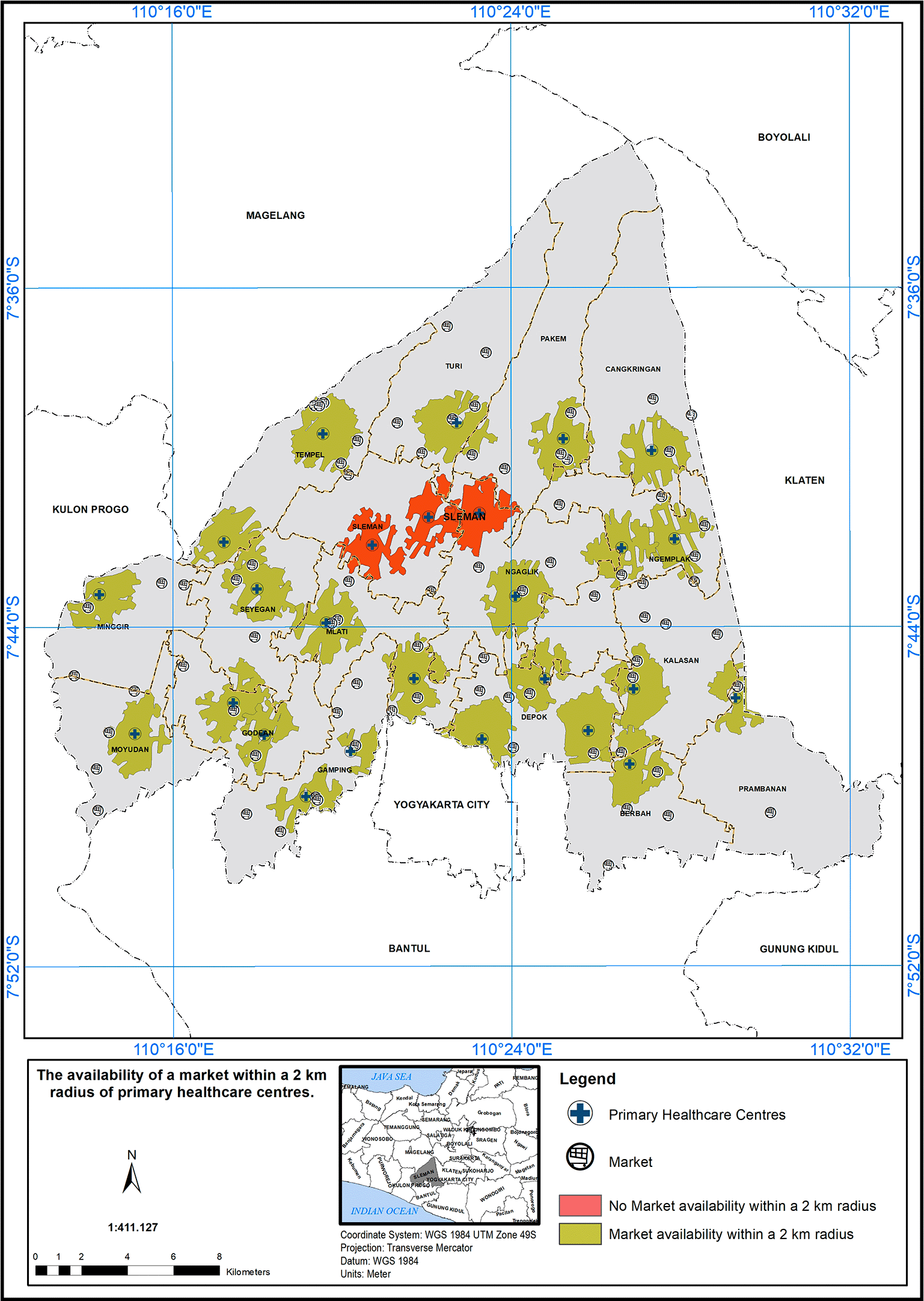
Table 1 provides an explanation of the individuals who receive services and those who do not receive services through the PHC center in Sleman District, based on the demographic standard. The location of the PHC center is determined by the population distribution in the region, following the demographic standard set by the Indonesian Ministry of Health, which specifies serving a population of 20,000 people per PHC.32 After applying the demographic standards, the study yielded the following findings. The total population of the Sleman district is 1,206,714 people. Out of 26 PHCs, 520,000 individuals are receiving services in accordance with the prescribed criteria. The population without access to services amounts to approximately 686,714 people. According to the demographic standard, a larger percentage of the population should have access to PHC services. The shortage in health centers represents approximately 41 PHC centers. Statistical data indicates that the highest number of individuals lacking services in PHCs is found in the Depok region, with a shortage of 130,526 people. The construction of seven additional PHC facilities is necessary. In contrast, the percentage of individuals lacking access to PHC services in Cangkringan District is relatively small, necessitating the establishment of one new PHC.
In this study, the researchers set a geographical standard to determine the service area of Primary Health Care (PHC) centers in the study area. The standard was based on a 5 km radius from the hospitals.25 According to the findings presented in the study, it was observed that 24 health centers met the specified standard for service area coverage in the presence of a hospital. This discrepancy between compliant and non-compliant health centers may have important implications for healthcare accessibility in the region. The availability of PHC services within a 5 km radius from hospitals could significantly impact the ease of access to healthcare for the population living in those areas. The PHC centers that fall within the service area are better positioned to serve their communities effectively, ensuring that a larger population has access to essential healthcare services. Factors such as distance, transportation infrastructure, and population density could play a role in determining the feasibility of establishing PHC centers in those regions.33,34 Policymakers and healthcare administrators may need to consider additional measures to address the accessibility challenges faced by these areas, potentially by improving transportation options or establishing additional health facilities to fill the service gap.
Overall, this study provides valuable insights into the distribution of PHC services based on geographical standards in the study area. The findings can serve as a foundation for healthcare planning and resource allocation, aiming to enhance healthcare accessibility and ultimately improve the overall health outcomes for the population in the region. However, further research and collaboration between various stakeholders, including government agencies, healthcare providers, and community representatives, will be necessary to address the challenges highlighted by the study and ensure equitable access to healthcare services for all residents.
The variations in PHC coverage across different sub-districts signify the importance of localized and targeted healthcare planning and resource allocation. It is evident that certain areas are more underserved than others, requiring specific attention and efforts to improve healthcare accessibility in those regions.
The study’s findings can serve as a foundation for evidence-based decision-making in healthcare planning and policy development. By identifying the areas with the greatest need for additional healthcare resources, policymakers can prioritize their interventions to achieve more equitable healthcare distribution and improve the health outcomes of the population in the study area. The implementation of a service scope based on a 2.5 km radius from schools is a commendable step towards improving healthcare accessibility and promoting the well-being of the school community.
It also encourages early intervention and preventive healthcare practices, which can contribute to better health outcomes among the school community.
The implementation of a service scope based on a 2 km radius from markets is a promising initiative to enhance healthcare accessibility in the study area.25 The findings in Figure 8 underscore the importance of such approaches in healthcare planning. However, it is crucial to continue evaluating and refining the service area to ensure that healthcare services effectively reach all populations, particularly those residing near markets. By addressing the challenges and disparities identified in the evaluation process, healthcare providers and policymakers can work together to build a more inclusive and accessible healthcare system, ultimately contributing to the improvement of community health and well-being.
The study highlights the importance of adhering to demographic standards to ensure that a larger percentage of the population has access to PHC services. There is a shortage of 41 PHC centers, based on the demographic standard of 20,000 people per PHC. This shortage of health centers directly affects the number of individuals who lack access to healthcare services in the region. Moreover, shortfalls indicate that a considerable portion of the population lacks timely access to essential healthcare, potentially leading to adverse health outcomes such as delays in medical interventions, and overall diminished quality of care. The underserved populations are especially vulnerable in emergencies, where delays in accessing healthcare can exacerbate injury or illness outcomes.
The study’s results have significant implications for healthcare planning and resource allocation in Sleman District. Policymakers and healthcare authorities need to take into account the demographic standards and the actual healthcare needs of the population when planning the distribution and establishment of PHC centers.
The study identifies significant gaps in healthcare access for a substantial portion of the population. Addressing these disparities requires careful planning, resource allocation, and the establishment of new PHC centers, particularly in regions with the greatest need. By addressing the shortages and expanding healthcare infrastructure, policymakers can work towards achieving a more equitable healthcare system that caters to the healthcare needs of all individuals in the district. Based on the findings, policymakers should prioritise establishing new PHC centres in underserved sub-districts such as Cangkringan, Pakem, Turi, and Prambanan, where healthcare access remains limited. These areas face high population density and disaster risk. In addition, alternative healthcare delivery models such as mobile clinics and telehealth services should be used to improve access in remote and disaster-prone locations. Implementing these strategies will strengthen healthcare accessibility, reduce preventable health problems, and improve community resilience.
In conclusion, there is a significant deficiency in the number of PHCs in the study area compared to the large population, both at the geographical and demographic standards level. The region is in urgent need of filling these gaps by establishing new PHC centers to meet the population’s needs and provide high-quality PHC services in line with international standards. This will also help alleviate the burden on central hospitals in the region.
Policymakers should consider expanding infrastructure by establishing additional PHC centers in densely populated, underserved areas, thus improving service reach. Additionally, enhancing community engagement through health education and preventive care programs can lower disease incidence, helping to manage healthcare demand in high-need areas. Improving transportation routes to PHCs would further facilitate access for those in distant regions. Finally, adopting a data-driven approach to resource allocation, utilizing GIS data, will ensure that health infrastructure evolves to meet population changes and emerging needs, creating a resilient and equitable healthcare system.
| Views | Downloads | |
|---|---|---|
| F1000Research | - | - |
|
PubMed Central
Data from PMC are received and updated monthly.
|
- | - |
Provide sufficient details of any financial or non-financial competing interests to enable users to assess whether your comments might lead a reasonable person to question your impartiality. Consider the following examples, but note that this is not an exhaustive list:
Sign up for content alerts and receive a weekly or monthly email with all newly published articles
Already registered? Sign in
The email address should be the one you originally registered with F1000.
You registered with F1000 via Google, so we cannot reset your password.
To sign in, please click here.
If you still need help with your Google account password, please click here.
You registered with F1000 via Facebook, so we cannot reset your password.
To sign in, please click here.
If you still need help with your Facebook account password, please click here.
If your email address is registered with us, we will email you instructions to reset your password.
If you think you should have received this email but it has not arrived, please check your spam filters and/or contact for further assistance.
Comments on this article Comments (0)