Keywords
Urban space, Human Mobility, Virtual Activity, Social Media, Instagram
Urban space, Human Mobility, Virtual Activity, Social Media, Instagram
This revised version has been significantly improved in response to the commentary provided by reviewers. Improvements include a more engaging title and a rewritten abstract highlighting the research findings. The introduction now clearly states the research gap, the nub question, and the aims of the study, and the methods section provides a thorough and reproducible description of the variables and analytical approaches used. The interpretation of results has been greatly extended, including quantitative evaluations of the maps generated. Finally, the discussion and conclusion sections have been substantially revised in order to allow a more in-depth investigation into the results, clearly answer the research aims, and strongly emphasize the novel methodological contribution in mapping a 'hidden' urban layer from social media data. The basic data and conclusions are left intact but are now expressed with greater clarity and rigour.
See the authors' detailed response to the review by Moh. Dede
Urban areas have been assessed inconsistently in the past and in previous decades, and this assessment was based on limited, sometimes incomplete, and erroneous data. This approach led to improper assessment and incomplete analysis of urban spaces. In most cases, this type of assessment and analysis is based on the preparation of a questionnaire and field observations by the researcher, even incorporating the researcher’s opinions. However, without questionnaires, field observations, and old data collection techniques, we can collect useful and real data about the living conditions of people in urban areas. This prevents the researcher from commenting on or interfering with the collected data directly or indirectly during data collection and case studies. The question may be how this happens With the development of new and innovative technologies, much of the data needed to analyze urban spaces has been created as unstructured data in the virtual world. Social media is one of the best ways to collect real and pure research data to analyze and evaluate urban spaces. These media have been introduced as a source of real and error-free data for researchers. The researcher’s intelligence and ingenuity in this direction have been introduced as the main leverage and drive in research, and can be very effective. Although prior work has illustrated the value of social media data in understanding human migration (Gao et al., 2017; Luo et al., 2016) and city dynamics (Shelton et al., 2015; Martí et al., 2019), there remains a significant lack in quantitatively linking specific online signals, like hashtags, with the spatial patterns of popularity of a particular metropolitan area. Previous research often places a focus on general patterns in a city or utilizes data from social media platforms like Twitter and Foursquare (Noulas et al., 2012; Quercia et al., 2015). The present study aims at filling this gap by raising the following question: How does a specific cultural tag on Instagram, #bookgarden, transform into measurable popularity for its corresponding metropolitan area in Tehran? The general objectives of the study are as follows: 1) propose a methodological framework for extracting and analyzing Instagram data through a spatially specific hashtag; 2) describe the spatial distribution and strength of virtual interactions in reference to the Tehran Book Garden; and 3) evaluate and describe the degree of impact that this online activity has on the popularity of the physical space. Through the execution of these activities, there is the hope that this study can offer a novel, fine-grained methodology in the evaluation of city spaces. Knowing that social media is considered a source of data, we can refer to the kind of social media investigated in this study. Instagram, a social media platform, is a popular medium worldwide that provides various opportunities for users. By providing these opportunities, users can share many real activities in the virtual world with friends, acquaintances, and people around the world. One of the most attractive features of this medium is hashtag. Hashtags allow users to share the geographic location of an urban space and mark that location as popular and preferred. This can attract people from cyberspace to real space, increase the popularity of desired urban spaces, and introduce people from cyberspace to real space. Human mobility is created by introducing and attracting people from cyberspace to real space. Human mobility is the beginning of people’s activities in a real space. Urban dynamics are based on different types of human mobility and are considered an undeniable necessity in the relationship between human mobility in a city (Dorostkar, 2025; Dodge et al., 2016; Miller and Shaw, 2015). To evaluate human mobility in a city, we can use the social media Instagram, which provides us with large data sources of people and geographical areas in general. These data do not deprive users of their rights in any way, because before accessing these data, Instagram users must confirm the rules and regulations for the use of Instagram, which means that access to individual data is possible for public use. Based on these interpretations, it is possible to identify and discover patterns of human movement and mobility in the virtual world and on Instagram social media based on the formation of a graph of human mobility (Gao et al., 2018; Poon and Pandit, 1996; Xu et al., 2015). In addition to being able to pave the way for urban planning and decision-making, Instagram can also be useful in the type of human mobility that identifies data from young or old populations, as young people are very important in the assessment of human mobility. (Martín et al., 2017; Nara et al., 2017; Panigutti et al., 2017; Wesolowski et al., 2015). An understanding of human mobility is possible by mapping it from different sources. Many studies have been conducted to identify human mobility and determine its pattern of human mobility to find a new way to solve this challenge. Social media data are considered a new source and method to identify these movements, and special attention is paid to the analysis of data from social media (Dorostkar and Najarsadeghi, 2024; Xia et al., 2011; Yuan and Raubal, 2014; Crooks et al., 2015; Gao et al., 2017; Cheng et al., 2011; Luo et al., 2016; Noulas et al., 2012; Quercia et al., 2015; García-Palomares et al., 2018; Hamstead et al., 2018; Quercia and Saez, 2014; Van Canneyt et al., 2012; Hochman and Manovich, 2013; Lee, Wakamiya, and Sumiya, 2013; Peña-López et al., 2014; Béjar et al., 2016; Chen and Roy, 2009; Dunkel, 2015; Tasse and Hong, 2014).
Demographic change is especially relevant to the resilience of cities, and needs to be examined from a comprehensive perspective that addresses both individual and collective influences (Wang and Taylor, 2018; Liao et al., 2019). Although a great deal of research on human migration has focused on external drivers, the fundamental drivers of this type of mobility have been less examined (Wu et al., 2014; Roy et al., 2019). Examining the mobility patterns of humans is critical to comprehending behavioral trends and interactions with the environment (Luo et al., 2016; Ebrahimpour et al., 2020). Traffic information facilitates the construction of urban mobility models (Cui et al., 2018), which describe how individuals’ movements influence collective dynamics at the urban scale (Porcher and Renault, 2021).
Urban and high-density residential areas may experience reduced human movement (Chan, 2020), whose identification is thus a top priority in city planning and research.
Social media is both a form of communication for citizens and a byproduct of technological progress that facilitates resource accessibility (Abbasi et al., 2017; Jiang et al., 2019). Moreover, it is a platform for gathering data to evaluate urban areas against strategic importance, physical travel patterns, and activity routines (Wang and Stefanone, 2013; Longley and Adnan, 2016), providing real-time behavioral insights about humans (Huang et al., 2020).
This study explores Tehran’s urban spaces by investigating the impact of the hashtag #book garden on Instagram and how it translated online presence into offline presence. The primary research question explores how #bookgarden is making urban spaces more attractive. The Tehran Book Garden, situated in the capital city of Iran (geographical coordinates: 35.7495° N, 51.4316° E) close to the National Library and Shahid Haghani Highway, was used as a case study. As is evident from the temporal popularity graph, peak traffic occurred at 4 PM.
Therefore, this study, with a review of the theoretical basis and some related studies in this field, deals with the process of obtaining data and methods of their analysis, and then the obtained findings are presented. Finally, the results are discussed and concluded.
The data of this study were collected quantitatively through Instagram and with the theme of Book Garden to identify people from different urban areas attracted to this attractive space, and by cross-linking these data on geographic maps we analyzed them. This step is considered the first part. In the second part, the communication between the spatial distribution of publishing posts to the Book Garden Center for urban regions of Tehran is evaluated, and the result is announced. In this section, the method of interpolation of urban space affecting book gardens is used as an important and effective space. Different interpolation methods have been developed according to the nature and type of data to be interpolated, the most important of which is the drawing method. In Map H, we used this method. This method is based on drawing irregular geometric shapes around known points, and is associated with the estimation of unknown values using simple mathematical methods. In map H, we used the triangulation method to measure the drawn irregular area by measuring the distances of each point on each side of the triangle from the center (the location of the book garden) and then calculating the average of these sides. This method shows which level of the city is effective in creating the attractiveness of the urban space of the Book Garden, which is the basis for forming map M, that is, the level of impact of the #book garden in Tehran.
The data for this study were collected in various ways. For the Instagram data collection, the API of this software was used as a graph. Access to this data is complex and requires programming skills (Python software: https://www.python.org/downloads/windows). The code and process of data extraction are presented as follows (the reason for joining Facebook and switching from there to Instagram is the limitation of Instagram from 2020 (https://github. com/facebookarchive/python-instagram ).
The API allows us to access large amounts of data on the web. The main reason for choosing the social medium Instagram for this study is the high penetration of this software worldwide. According to 2018 statistics, Instagram has approximately 1 billion active users, which shows the strength of penetration and the volume of data collection in this sector. Based on these statistics and unrestricted access, this social medium was used to collect data (Cortese et al., 2018) and investigate the attractiveness of urban space in this study. The data used in this study consist of public data with unrestricted access extracted from the Internet and Instagram software based on a special hashtag called #bookgarden and the location of Tehran Book Garden urban space (coordinates: 35.7495–51.4316), which can be captured and tracked in Instagram posts from January 21, 2022, to January 21, 2023. The number of hashtags used amounts to 5631 posts with location (linking the location of the sender’s post in the Instagram software), which, of course, is obtained by deleting unrelated posts and hashtags. According to the evaluations, this number was satisfactory for the present study. Hashtags associated with Instagram posts can be used by keywords to support a topic or for advertising, and show different results. Our datasets were fully categorized and accurately extracted from Instagram and included the #bookgarden and the geographic location of its urban space in shared texts, locations, users, related posts, etc., forming a complete but limited dataset in one place. Different methods can be used to analyze hashtags in posts and their texts (Solis and Webber, 2012; Valderrama-Santomé et al., 2019; Dans and González, 2019; Paül, 2018). However, in this study, to achieve a new and innovative method, we analyzed the hashtags in the form of graphs on the site plan of Tehran and drew the connection with the urban space of the book garden created. Then, using the same graphical connectivity, we ranked the neighborhoods and urban areas according to the influence and attractiveness of urban spaces for the presence of people. This study was conducted in combination to examine a larger area and determine the relationship between the attractiveness of urban spaces and social media Instagram. In another study, the relationship between users and location was determined using Instagram posts to determine the direction of movement of these individuals (Giordano et al. 2021).
The innovation in this study comes from the method of data collection and analysis, which led to the formation of pure research that can be used as a pattern in other studies.
Data Analysis Procedures and Variables: The primary variables considered within the 5,631 geotagged tweets consisted of: 1) Timestamp (used to define temporal patterns), 2) Geographic Coordinates (latitude and longitude for spatial depiction), and 3) User ID (used to measure distinctive user activity and concentration). The data analysis followed a clear-cut methodology designed to ensure reproducibility: First, the raw data was put through a cleansing and filtering process targeting the #bookgarden tag and the Book Garden location. Then, data points were spatially depicted on a base-map of Tehran’s municipal districts (Maps A and B). A spatial network analysis was subsequently carried out in order to define relationships among user points and the Book Garden (Map C). Finally, the area of influence was computed using the defined Triangulated Irregular Network (TIN) method. The important variable in the calculation of the interpolation was the average distance among the vertices of the influential triangle (points 3, 4, 5) and the Book Garden (point 2), producing a quantitative value (4) representing the strength of the relationship for the final zone mapping outcome (Map M).
Figure 1 shows the demographic distribution of Instagram users with open access to their data in the book garden. From this Figure, it can be seen that, particularly between January 21, 2021, and January 21, 2022, users acted with an average and reasonable distribution rate. This shows the effectiveness of the #book garden and the creation of attractiveness of the urban space Book Garden for users. Another point that stands out in this diagram is the normal distribution of data based on this hashtag at different time intervals, which expresses the attention of users following the Book Garden for this urban space. On the left side of Figure 1, there is a chart of the most popular times for using the urban space of the Book Garden. In this chart, it is clear that the most popular time of use for users is 4 p.m. and was introduced as an indicator of the time of day, while 9 to 11 a.m. was the least popular in the morning, and 8 and 7 p.m. were the least popular in the evening. Of course, this low popularity at night has another reason: the geographical location of the book garden and access to it. Access to the Book Garden usually involves cars and subways. At night, these two access roads face high traffic volumes because of the heavy traffic on the highways leading to the Book Garden and the interference with the time when city residents return from work to their residences by subway. This is one of the reasons for the decreasing popularity of the Book Garden at night.
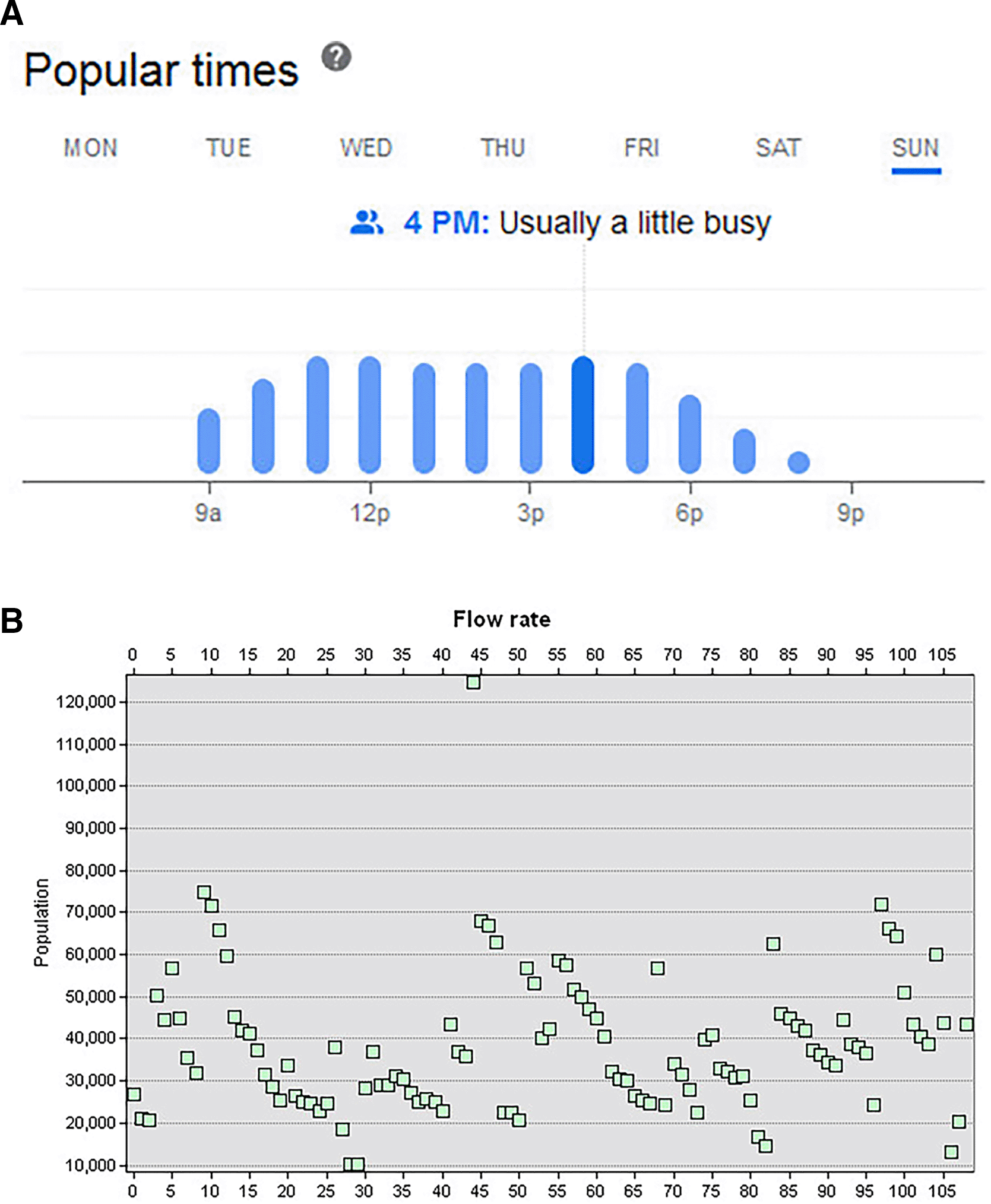
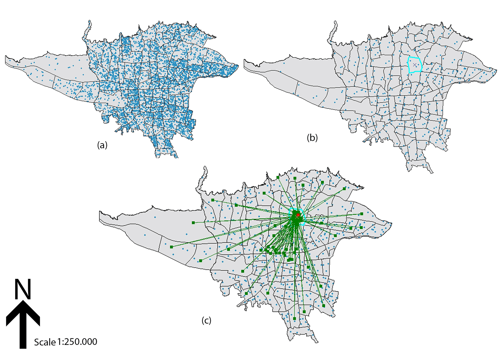
Figure 2 map A shows the penetration rate of Instagram posts with the hashtag #bookgarden in Tehran, taking into account all hashtags associated with the post. As can be seen from this map, the central and southeastern part of Tehran is a very active space in the virtual world and has many differences compared to other neighborhoods and urban areas. In this map, we used the data on #bookgarden based on neighborhoods and urban areas delineated and identified by Tehran Municipality. In this map, the western part of the city faces low and even empty distribution due to its distance from the geographical location of the bookgarden and also due to the location of the industrial part of the city in this area. The opposite is true for the central part of the city, which means that due to the proximity of the city center to the geographical location of the Book Garden, we see the most virtual activity on Instagram from this part. Figure 2 Map B shows the spread of #bookgarden along with its geographical location, and as can be seen in the map, the western part of the city is almost empty, and in this regard, no virtual activity can be seen from this part. In this map, the location of the book garden is marked in light blue. Comparing maps A and B, we can see that a considerable number of users have not indicated their geographical location next to the hashtag. Nevertheless, there are a significant number of posts with the conditions considered in this study that are located and indicated in map B. This map is used as the basis for further data analysis. Using map B and the geographic location of the book garden, we attempted to link the contributions to the book garden in the city; the results are shown in map C. Figure 2 map C shows the progression of the #bookgarden broadcast and its connection to the location of the bookgarden as an attractive urban space in 2021. In this interconnection, we used situational data and the #bookgarden to analyze all activities with open and public access on Instagram, which showed that the central part of the city had the most interconnection of said data. In this area, where bookstores and various scientific and cultural spaces are located, the most virtual activities were carried out, which shows the high human and virtual activity in this area. The main questions for further analysis and calculation of the networked area in this part of the city can be divided into two parts: the impact of users visiting the Book Garden and publishing posts with the #bookgarden and displaying the location on Instagram, and the impact of published posts with these terms on the popularity of the Book Garden urban space. To analyze and accurately measure this section, we used the interpolation method described in map H. Map C shows the neighborhoods and urban areas where the Book Garden received the most popularity over the course of a year.
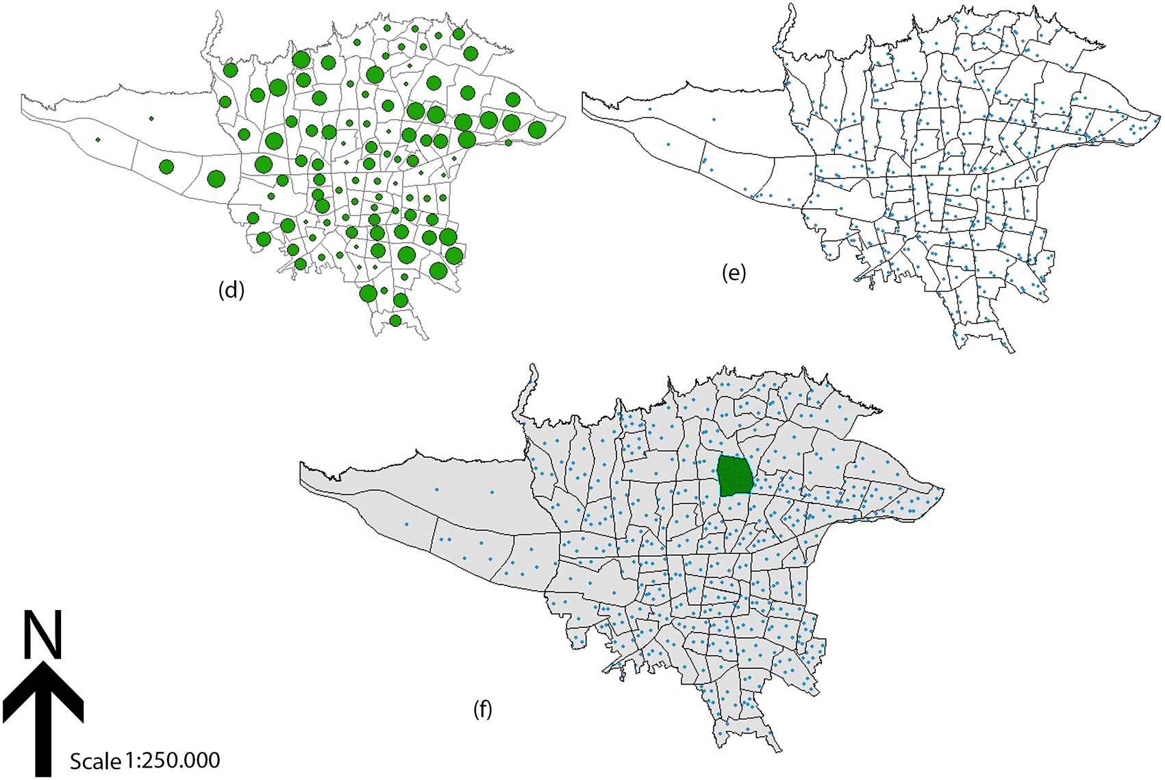
In Figure 3 Map D, the volume of active users in the neighborhoods and areas of Tehran is shown. This map also shows that the central and southeastern parts of the city have a significant number of active users. However, the most noticeable part of the city is where most of the communication networks for the popularity of the Book Garden’s urban space have emerged, despite the small number of active users. The map states that we will see stronger networks with stronger relationships if there is more virtual activity in the area of communication networking related to the #book garden. Map E shows the activity of active users on Instagram with the #bookgarden, titled Virtual Activity Map and Hidden Urban Layer, and has recorded the user activity. Map F shows the location of the book garden in the urban areas of Tehran and the virtual activities around this area. Map E shows individual users as points, whose size varies in direct proportion with the amount of posts linked to the hashtag, and thus generates a depiction of ‘virtual activity’ that mirrors the corresponding cultural stratum of the city.
By interpreting and reviewing the above six maps, the analyses found are referred to as the results of this study. In Figure 4 map G, which shows the network radiance from the maximum radius of influence of the #bookgarden to the minimum radius, it is clear that the location of the bookgarden is radially and communicatively influential as an impact hole in its environment. This effect is based on the #book garden and the geographical location of the users who mentioned these two components in their posts. Further, we move away from the center of the Book Garden area, the clearer it becomes that the impact of the #book garden decreases and becomes weaker; conversely, the closer we get to the Book Garden area, the greater the impact of the virtual activity. We also reached a new point in our study. That is, the location of the Book Garden is effective and influential in certain areas of the city. By locating cultural, scientific, and artistic activities, these areas are introduced as close poles and connected to the urban space of the Book Garden. In the studies carried out below, we represented this area on map H. In this map, which calculates the area affecting the geographical location of the Book Garden as a three-part area, we process the power of social media Instagram to increase the popularity of the Book Garden’s urban space based on the activities and virtual activity in these social media. In this map, position 2 is the location of the Book Garden, and vertices 3, 4, and 5 are the hypothetical vertices where most virtual mobility on social media Instagram has occurred. Position #1 is the area we are looking at, and we intend to calculate this area to determine the virtual activity. To study the impact of the geographical location of the Book Garden in the cultural, scientific, and artistic fields, we switched to the interpolation calculation method, which allowed us to calculate the desired area, an irregular triangle.
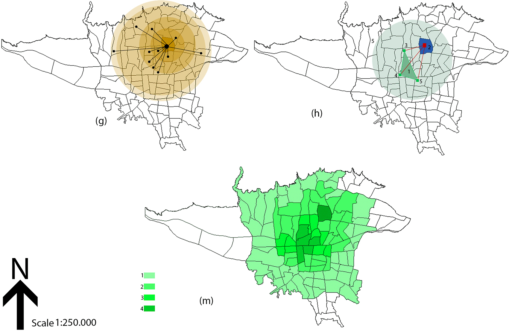
Interpolation calculation (drawing an irregular triangulation): In this method, an irregular triangle is formed by connecting the known points shown in map H, with the known points shown at the vertices of each side. To calculate the colored area inside the triangle, it is sufficient to use the simple average of the known values at each vertex of the triangle (points 3, 4, and 5 at each vertex) to calculate the unknown value. According to the distance of each vertex of the triangle to the location of the Book Garden (location of the Book Garden, number 2), the average colored area of the triangle (colored area number 1) is equal to four, indicating the strong connection of this plane as a plane that influences the attractiveness of the urban space of the Book Garden. Finally, with all the analyses conducted, we came to map M, which shows the effectiveness of #bookgarden in creating a popular urban space among the neighborhoods and urban areas of Tehran in four categories (1: very low impact, 2: low impact, 3: high impact, 4: very high impact). The #bookgarden in this map has a greater impact on the location of the bookgarden and cultural, scientific, and artistic areas; gradually, with the reduction of virtual activities on social media Instagram, the impact on the urban space of the bookgarden has decreased, and with decreasing effect, the color of the map also fades.
This study endeavored to develop a methodology to assess the popularity of urban places by exploiting the use of Instagram data, and tested it on Tehran’s Book Garden in particular. The outcome shows that social media-generated digital traces can be a powerful, unbiased indicator of reality-based urban activities (Graham et al., 2014; Shelton et al., 2015). Directly in line with our research objectives, we: 1) created a reproducible API-based method for extraction and analysis of geotagged hashtag data; 2) successfully visualized the geographic spread of activity, which showed a striking concentration of virtual activity in the central and southeastern Tehran regions, a distribution informed by both proximity to the Book Garden as well as by configuration of the arrayed cultural resources (Maps A-C); and 3) made a novel contribution by establishing a quantitative zone of influence, and identifying a central zone (Level 4 impact zone) that operates as a ‘hidden layer’ boosting the popularness of the built space.
The triangulation approach demonstrated its efficacy in transcending simple visualization to furnish a quantifiable assessment of the hashtag’s influence. This “hidden layer” is characterized not as an administrative division, but rather as a functional area delineated by common cultural identity and engagement, which becomes apparent through its digital footprints. It functions as a tripartite system: the observable physical realm (Book Garden), the concealed urban stratum (cultural zone), and the digital cyberspace (Instagram activity), with each component exerting influence upon the others.
The observed temporal trend, characterized by maximum engagement at 4 PM, succeeded by a reduction associated with traffic congestion, highlights the limitations of digital prevalence that remain influenced by tangible infrastructure. This convergence of virtual and physical access represents a significant consideration for urban planners. Briefly, the fundamental value added by the work is that it brings a novel methodological approach that combines spatial network analysis and geometric interpolation in order to quantify the effect propagating through a digital marker within a physical space. The methodology generalizes to a range of different urban settings and cities, giving scholars and city planners a tool by which they can test attractiveness based on real-time, organic user activity rather than on traditional surveys. Future work could apply the method to exploring differences between different kinds of spaces (e.g., public shopping malls compared to public parks) or in tracking changes in popularity over longer timeframes.
• Source code available from https://github.com/facebookarchive/python-instagram .
• License: https://www.python.org/downloads/windows.
| Views | Downloads | |
|---|---|---|
| F1000Research | - | - |
|
PubMed Central
Data from PMC are received and updated monthly.
|
- | - |
Provide sufficient details of any financial or non-financial competing interests to enable users to assess whether your comments might lead a reasonable person to question your impartiality. Consider the following examples, but note that this is not an exhaustive list:
Sign up for content alerts and receive a weekly or monthly email with all newly published articles
Already registered? Sign in
The email address should be the one you originally registered with F1000.
You registered with F1000 via Google, so we cannot reset your password.
To sign in, please click here.
If you still need help with your Google account password, please click here.
You registered with F1000 via Facebook, so we cannot reset your password.
To sign in, please click here.
If you still need help with your Facebook account password, please click here.
If your email address is registered with us, we will email you instructions to reset your password.
If you think you should have received this email but it has not arrived, please check your spam filters and/or contact for further assistance.
Comments on this article Comments (0)