Keywords
Wireless Sensor Networks (WSNs); Precision Agriculture; RSSI–DV-Hop; Hybrid Localization; Non‒Line-of-Sight (NLOS); 2D/3D Localization.

This article is included in the Manipal Academy of Higher Education gateway.
Wireless Sensor Networks (WSNs); Precision Agriculture; RSSI–DV-Hop; Hybrid Localization; Non‒Line-of-Sight (NLOS); 2D/3D Localization.
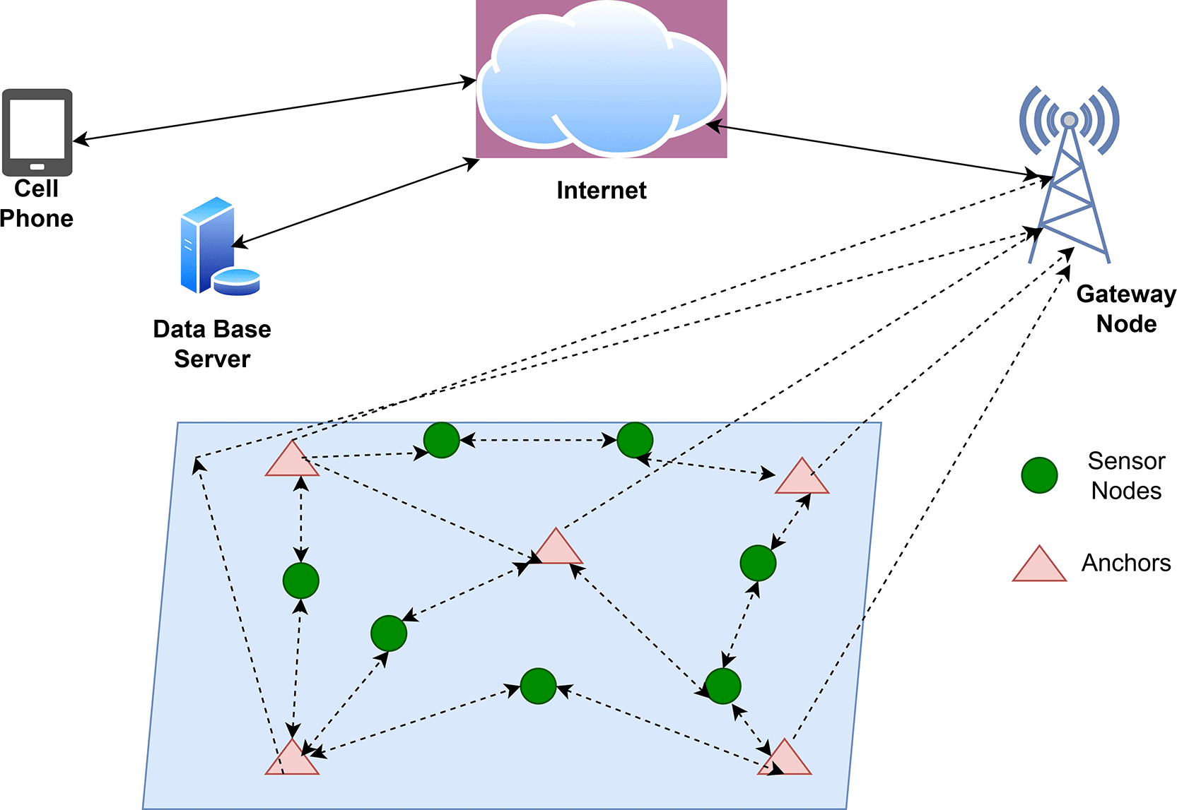
Wireless sensor networks (WSNs) have been introduced as a significant technology in precision agriculture, by which parameters such as soil moisture, pH, temperature, humidity and nutrient content can be monitored with sensor nodes spread over farmland. The placement of these sensor nodes is important for determining decisions such as irrigation scheduling, applying fertilizers, monitoring crop health, and predicting yield. Figure 1. represents the overall structure of a precision agriculture system based on a WSN where sensor nodes scattered over the field gather sensor data and transmit these data via multiple wops wirelessly to a gateway node. The gateway provides a point of contact between the field network and external facilities, transmitting the aggregated data to a centralized server via the internet (cloud) and allowing remote users to access it via computers or mobile devices and make real-time decisions. Localization problems are, however, worsened in large and uncontrollable agricultural settings such as greenhouses, orchards and open fields by the sparse deployment of anchors and vegetation attenuation of signal and nonline-of-sight (NLOS) conditions. Hence, energy efficiency and environmentally adaptive localization methods need to be enhanced to enable the reliable operation of WSN-based precision agriculture systems.
The rising global need for food security, water scarcity, and climate change and the need for sustainable agricultural practices have spurred the development of smart agriculture. Smart farming is based on real-time data and information to control irrigation, fertilization, pest control, greenhouse management, and yield forecasting. Recent research has shown that IoT-based WSN technologies can enhance food productivity via continuous monitoring and control. Sensor-based nutrient estimation systems have been devised for estimating the levels of nitrogen, phosphorus and potassium (NPK) in real time, and clustered IoT-WSN systems have been proposed to improve energy efficiency and extend the lifetime of the system on large-scale farms.70 While data sensing and wireless communication technologies have improved significantly, precise localization is among the most important aspects of agricultural WSN deployments. Localization involves estimating the coordinates of the deployed sensor nodes. Without knowing the location of the sensors, sensed data cannot be linked to specific field zones, restricting their use in irrigation zoning, disease mapping, precision spraying, robotic navigation, livestock tracking, and site-specific crop management. Hence, robust localization is crucial for transforming sensor observations into valuable agricultural knowledge.
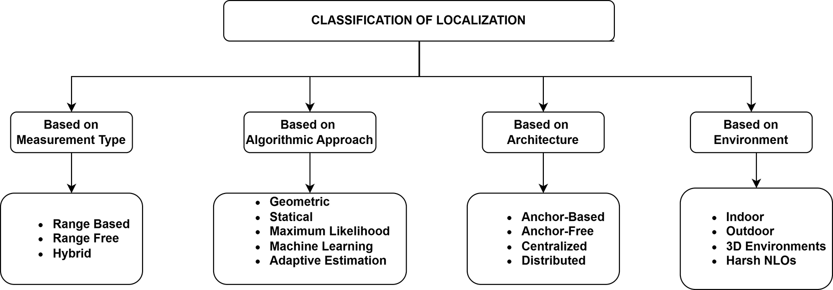
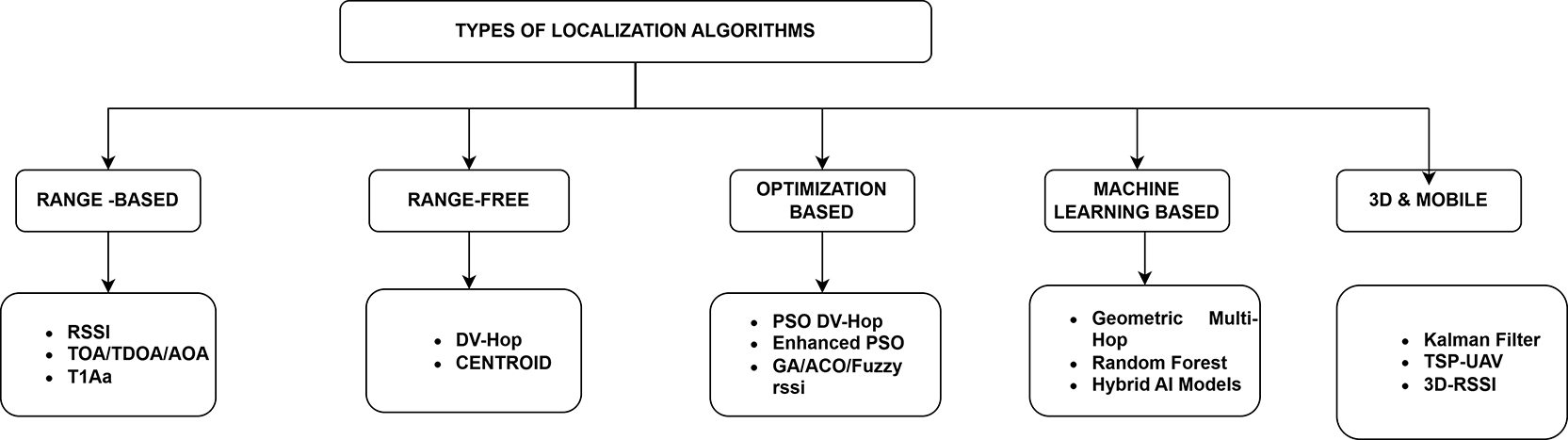
Compared with laboratory and laboratory environments, farming environments pose some challenges for localization systems. Environmental factors such as plant density, crop canopies, greenhouse metallic structures, terrain and soil moisture, farm machinery, and seasonal variations affect signal propagation. This frequently leads to multipath fading, attenuation and non–line-of-sight (NLOS), which in turn affect the localization accuracy. In addition, many farming scenarios are deployed over large areas that are remote, and changing batteries, maintaining, and establishing costly infrastructure are difficult. Therefore, agricultural localization systems need to be accurate, energy efficient, scalable, and reliable and have low hardware complexity. Traditional global navigation satellite system (GNSS) techniques offer high accuracy in open fields and are typically adopted for tractors and other autonomous agricultural vehicles. However, the accuracy of GNSS suffers in orchards, greenhouses, covered farms, dense plantations, and indoor livestock farms because of the loss of signal strength. In recent years, researchers have explored other WSN localization techniques, such as the received signal strength indicator (RSSI), time of arrival (TOA), time difference of arrival (TDOA), angle of arrival (AOA), centroid, DV-Hop, fingerprinting, Kalman filtering, particle filtering, and machine learning. Recent research has also demonstrated the effectiveness of optimization- and neural network-based localization in enhancing positioning accuracy in greenhouse and NLOS agriculture.71 An organized segmentation of localization methods and algorithms in WSNs is displayed in Figure 2. and Figure 3.
Range-free methods (e.g., DV-Hop, centroid) are simple but tend to be less accurate. Range-based techniques such as RSSI, TOA, TDOA, and AOA offer better accuracy, but they are prone to noise, clock skew and multipath effects. Optimization and machine learning approaches increase the flexibility but are associated with higher computational costs. Therefore, hybrid localization solutions that integrate multiple techniques have attracted significant attention because they offer a trade-off between accuracy, energy consumption and deployment practicalities. While much work has been done, there is no single localization technique that is suitable for all agricultural applications. Flat fields, orchards, greenhouses, sloping land, irrigation farms, and remote plantations present different communication and propagation challenges. Moreover, issues such as communication errors, low density of anchor nodes, dynamic environments and 2D/3D deployment scenarios are still not fully investigated. Hence, a comprehensive review of existing localization techniques is clearly needed to critically analyse and compare the performance of different approaches and determine the most appropriate frameworks for precision agriculture applications.
This paper reviews hybrid localization techniques in wireless sensor networks (WSNs) for precision agriculture. This study categorizes the main localization algorithms; compares their efficiency in terms of accuracy, energy, scalability, cost and robustness to environmental conditions; and highlights their suitability for modern smart farming systems. An emphasis is on adaptive hybrid methods that can enhance the localization performance in 2D and 3D environments under adverse agricultural conditions. Finally, existing challenges and future work toward reliable, energy-efficient and smart agricultural localization systems are highlighted.
The main aim of this review is to study available localization techniques and critically evaluate their performance trade-offs and identify gaps in the research that apply to new-generation deployments of WSNs. Recent research has addressed several complicated situations, including NLOS propagation, 3D positioning, tracking of mobile nodes, and severe environmental factors.1–5 Superior optimization techniques and learning-based approaches, such as PSO, GA, ACO, Kalman filtering and ML-based models, have demonstrated a better ability to adapt to nonuniform and large-scale networks.6–10 With the application of random forest and multilateration methods, hybrid ML geometric models can also enhance the use of RSSI in localizing indoors.11 The issues with 3D localization, such as high computational complexity, decreased accuracy and lower availability of anchors, have inspired various improved methodologies.12 Some of these are fuzzy logic and virtual anchors, GWO-FA optimization to increase accuracy and energy efficiency, and K-fold assisted ML schemes to reduce redundant transmissions.13 Other significant developments include TSMCL-BPSO to achieve faster convergence at mobility,14 mutation-augmented PSO to achieve NLOS mitigation15 and hybrid PF-TDOA schemes that exhibit enhanced robustness.30 It has been between,16,17,29 where much effort has been given to enhancing accuracy, energy efficiency and scalability. RSS-AMLE, which uses hybrid schemes that are more robust, is provided,18,19 less selective-beacon schemes are made to optimize anchor energy,20 and anchor-light multihop schemes can be used to facilitate inaccessible deployments.21
Hierarchical methods, which are cluster-based, develop scalability in rugged terrains,23 whereas UAV-assisted methods optimize altitude, which is used in 3D localization.24 The introduction of UAV-based approaches into this review is not discussed as a new contribution, but it is included in a single comparison, including range-based, range-free, optimization-based, ML-based, anchor-light, and UAV-assisted localization techniques. The UWB + UKF combination is more accurate for indoor NLOS.25,26 Fuzzy logic, swarms and mobility-based filtering also increase resilience in dynamic environments.27–29 Time-based localization has also been enhanced in clock-drift correction, hop-size refinement and environmental modelling. Other techniques, such as MNPR31 and DV-Hop,32 use weighted multihop estimation and MMSE-based hop correction coupled with multilateration, fingerprinting and Kalman filtering. Furthermore, the accuracy of TTF smoothing is improved, and compared with FP and MLT, hybrid H-IPS is more accurate by 21 and 52%, respectively, and has less than 2 m of error in 80% of the tests.33 The scalability of large networks is provided by distributed gradient-descent localization with pseudo anchors34 and a Gaussian-based filter using a received signal strength indicator (RSSI) with multiple path effects in.35 The mentioned research suggests an indoor localization technique that employs a GA and PSO36 to optimize the parameters of the neural network.
Lightweight encryption is also being utilized in the approach to enhance resistance to Sybil attacks. The authors report positioning errors of 0.23 m and 0.43 m under varying test conditions with strong resistance against attacks less than 1 m. Existing techniques can be divided into nine categories: range-free, range-based, optimization-driven, machine learning-based, hybrid fusion, filtering-based, anchor-light, UAV-assisted, and environment-specific techniques. The classes have various trade-offs in terms of accuracy, scalability, energy efficiency and hardware requirements. Schemes based on range (e.g., RSSI, TOA, TDOA, and AOA) are more accurate, as they take advantage of the physical characteristics of signals but demand extra hardware and cannot perform in noise and NLOS. Conversely, range-free schemes such as DV-Hop, Centroid and APIT32,39 are only based on network connectivity and are very easy to implement; however, in general, they are less accurate. Anchor-based systems have fixed reference points on which localization takes place, whereas anchor-free schemes offer greater freedom in restrictive or inaccessible spaces. Recent literature focuses on the use of ZigBee/IEEE 802.15.4-based systems in underground mines,37 hybrid routing designs such as HOEEACR38 and improved 3D localization using modified Savarese algorithms.40 Further reduction in localization uncertainty41–44 is achieved by means of optimization and distributed computation techniques such as beamforming, graph theory and multiobjective search algorithms. The hybrid schemes, which are RSSI and DV-Hop,45 FANET-based filtering schemes46 and TOA/TDOA-based NLOS schemes, which include RPTW47 and MM-based NLWLS,48 all enhance localization accuracy.
Lightweight hybrid AOA/RSSI schemes have lower hardware complexity in a GPS- denied environment,49,50 whereas strong NLOS correction schemes such as LMR51 increase 2D and 3D accuracy. The new architecture combines reinforcement learning (e.g., DQARL52) with probabilistic filtering,53 ML-based positioning,54 and anchor-free barycentric techniques55 to enhance noise and mobility resiliency. Radio-SLAM-based systems can detect LOS and NLOS paths and can also greatly improve the localization accuracy in multipath scenarios.56 Further hybrid schemes also use modern TOA/AOA extraction techniques59, including IMEMP,57 scatterer-aided estimation,58 ray-tracing-enhanced systems60 and TDOA-based antenna arrays in GPS-denied situations.61 Scalable solutions based on graph-theoretic anchor placement,62,64 low-power probabilistic ZigBee localization,65 multilateration refinement,33,63 mobility prediction66 and sensor fusion (TDOA+RSSI)67 still improve the positioning of nodes in dense and obstructed networks. Research also indicates that the optimal placement of the anchor strongly affects the localization accuracy when the spacing of the anchors is equilateral and uniform, resulting in less error. Recent ANS and ANP models68 refer to the use of graph geometry and PSO to enhance anchor selection and placement to provide more trustworthy WSN localization. The practical applicability of localization is clear because of recent application-based WSN implementations. The systems of precision agriculture that measure soil pH, soil humidity, and soil nutrient concentration use distributed sensors in the form of nodes whose spatial resolution directly affects the optimization of crops and the planning of irrigation schedules.69
Equally, GSM-based WSN systems to be used in rural surveillance emphasize the issue of scalability and connectivity, which are well reliant on the node location that is confidentially determined. Receivers NLOS-sensitive RSSI localization models that have been optimized to be more aided by filtering and optimization techniques have been suggested in controlled agricultural settings such as greenhouses to allow robotic navigation in the event of signal degradation.70 Several studies have investigated the use of wireless sensor networks (WSNs) to enhance monitoring and performance in agriculture. Surveyed localization,71 routing and security strategies in WSNs, highlighting the crucial role of node location in data gathering, routing and energy efficiency. WSN architecture,72 in which sensor nodes are made of sensing, processing, communication and power units, with emphasis on WSNs’ use in environmental and agricultural monitoring. Additionally,73 developed an improved particle swarm optimization (IPSO) routing technique to increase lifetime and energy consumption, which is ideal for large-scale agricultural deployments.74 presented an IoT-based clustered WSN for agriculture with sleep/wakeup scheduling and LoRa communication to achieve energy efficiency and long-term monitoring in the field. These works suggest that WSNs are very suitable for precision farming, but these issues include localization accuracy, scalability, and energy management. Extensive simulation research has been conducted on localization algorithms under different node densities and deployment conditions and on how the algorithm performs in terms of accuracy, energy consumption and robustness. Common simulations involve between 50 and 500 sensor nodes, with the anchor nodes constituting 5–20% of the network. DV-Hop and Centroid are range-free and reasonably effective for dense and open deployments in irregular terrain, forests or tunnels; they have an error rate of up to 30%.
Conversely, range-based schemes such as the RSSI, TOA and TDOA tend to be more precise (<5 m) but are more expensive to implement and are very susceptible to multipath and NLOS indoor environments. As an example, the RSSI (19), (51) achieves 1.235 m accuracy and 100 nodes, whereas in the TOA and TDOA (8), (44), and (47) algorithms, the localization error is halved by 20–40%, averaging 1.235 m. The techniques are specifically efficient under problematic conditions such as urban canyons or mountainous areas.6,7,10 Machine learning, random forest and fuzzy logic-based solutions with 50–150 nodes in controlled indoor environments utilizing signal patterns and probabilistic modelling to allow real-time adaptation and an accuracy of 3–13 m can be obtained in mobile or 3D environments, including UAV-assisted deployments,24,56,66 and tracking frameworks on the basis of Kalman filtering and hybrid RSSI-TOA models. Most of the studies use realistic propagation models (e.g., log-normal shadowing), with different anchor densities and deployment ranges between 100 × 100 m and 1000 × 1000 m. Generally, the results always suggest that hybrid, optimization-enhanced and adaptive filtering-based methods perform better in various environments and deployment requirements than conventional standalone methods do.
Range-free localization algorithms are localization algorithms that rely on network connectivity and hop-count data to approximate the position of nodes without depending on physical distance or angle measures. DV-Hop, Centroid and APIT are the classical methods used because they have minimum hardware requirements and are scalable. However, they lose much accuracy in localization in dense networks, irregular terrains, and NLOS environments with cumulative hop-size errors.
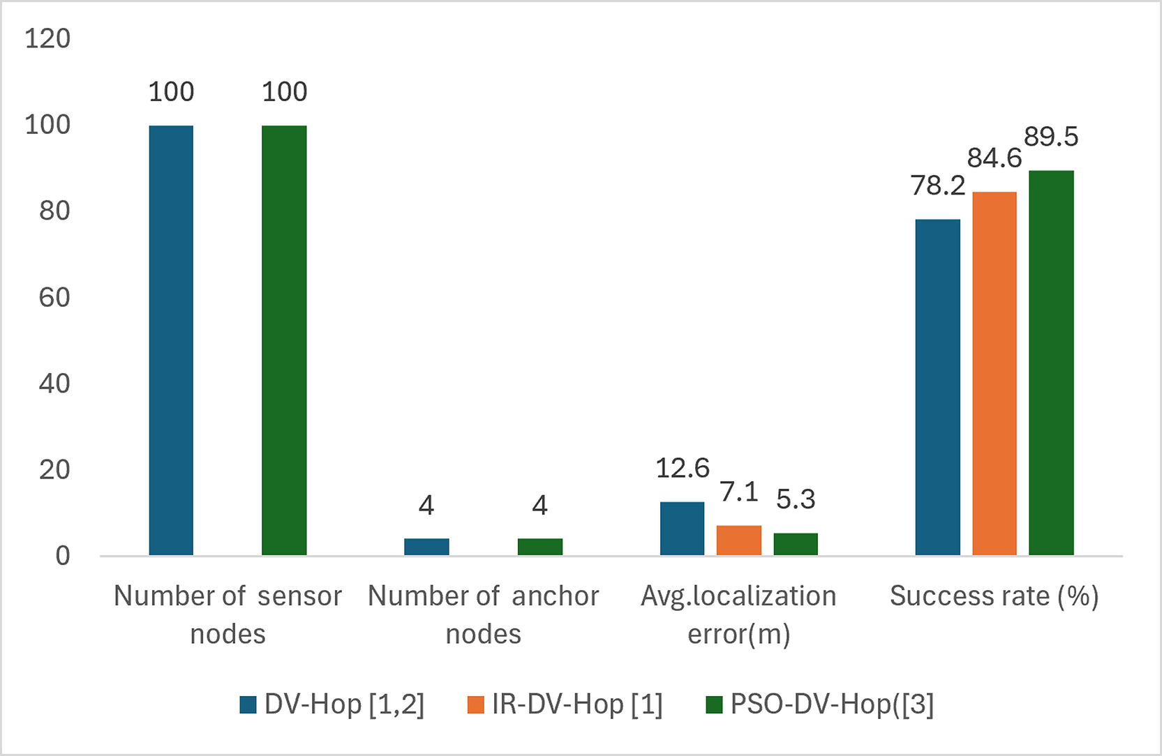
There is interest in range-free localization methods in deployments to sporadic environments, including tunnels, forests, mountains, urban canyons and indoor NLOS environments. The techniques are based on network connectivity, as opposed to physical signal measurements. In this type of environment, classical DV-Hop methods are more prone to large hop-count errors, although more modern versions, such as IR-DV-Hop1 and PSO-DV-Hop,3 add refinement stages, environmental modelling and optimization to reduce error. Although range-free methods are still cost effective and energy efficient, they have remained limited in highly irregular terrain where localization errors could be more than 12 m, as demonstrated in Figure 4. Nevertheless, these enhanced variants are more accurate for dense deployments because hop-based distance estimation is more accurate.
The range-based methods use the physical signal properties of the received signal strength indicator (RSSI), time of arrival (TOA), time difference of arrival (TDOA), and angle of arrival (AOA) to determine internode distances or angles. Compared with range-free algorithms, such algorithms tend to be more accurate in terms of localization, especially when there is a line-of-sight (LOS) between the receiver and the source. They, however, perform significantly worse under NLOS conditions because of multipath propagation, synchronization errors and equipment limitations, the details of which are reported in Table 1.
| Algorithm | No. of Sensor nodes & Anchor nodes | Avg. Localization Error(m) | Energy Consumption | Success Rate (%) | Environment |
|---|---|---|---|---|---|
| RSSI- based2,4 | Not mentioned | 6.7 | 1.05 | 82.3 | Indoor, urban NLOS |
| TOA/TDOA & AOA4 | 100 & 4 | 3.2–4.5 (ideal), 7.8 (NLOS) & 4.0 (ideal), 6.5 (urban) | High | ~ 90 (ideal) 85.0 | NLOS and synchronized scenario Requires antenna arrays |
| RSSI, TOA, TDOA, AOA16 | 100 & 5 | RSSI: 6.8, TOA: 3.1, TDOA: 3.8, AOA: 4.0 | RSSI: 80–85 | Indoor/Outdoor |
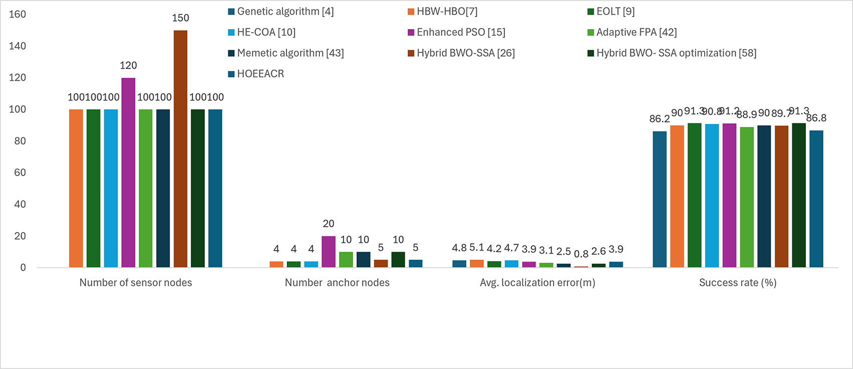
The localization techniques based on optimization use metaheuristic algorithms such as particle swarm optimization (PSO), genetic algorithms (GA), ant colony optimization (ACO), and hybrid swarm intelligence techniques to reduce the localization error. Such algorithms help greatly decrease the localization error through iteration of position estimates but increase computational cost and convergence time, which lessens their usefulness in real-time localization in very resource-constrained WSNs. The PSO-DV-Hop, enhanced PSO, HE-COA3,7,10 and HBW-HBO15 algorithms are shown in Figure 5. decrease the localization error to only 3.9–5.1 m, but they also have moderate and low energy costs. These methods work especially well in dynamic, NLOS, and large-scale WSN environments and are usually matched to dynamic WSN topologies.
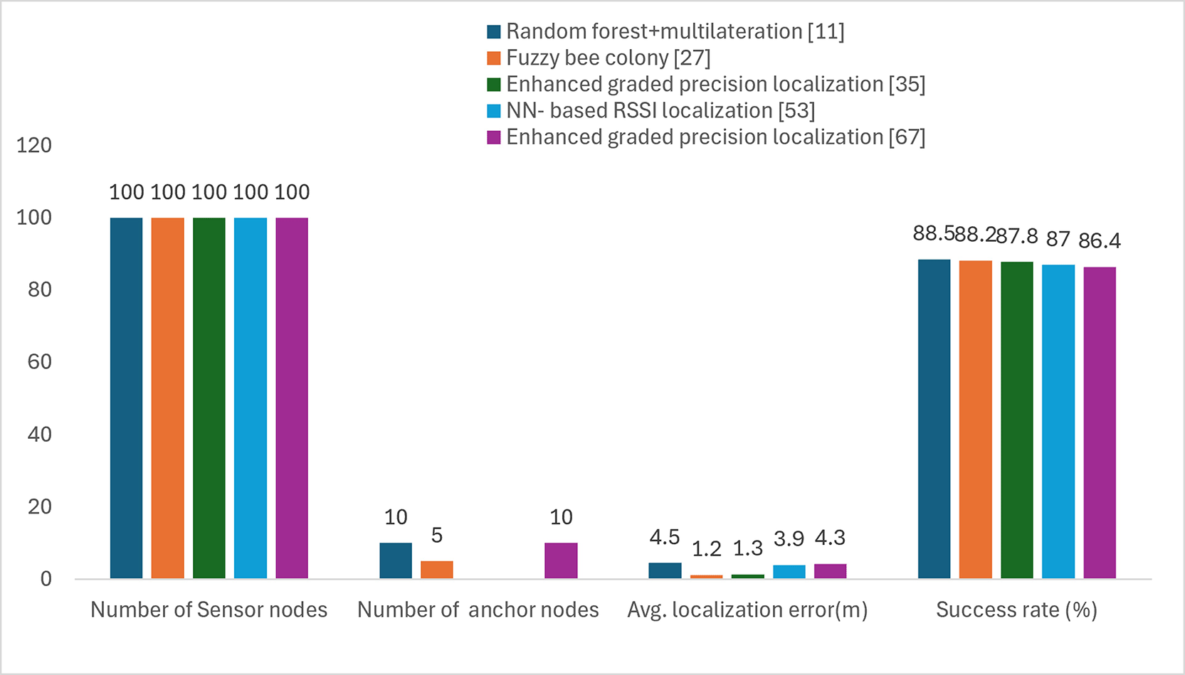
Machine learning (ML) algorithms such as random forests, neural nets, fuzzy logic systems, and reinforcement learning have been applied to WSN localization. ML-based solutions are highly flexible and resistant to environmental changes, but training data, memory and inference calculations are needed, which are not available for low-power sensor nodes. Therefore, lightweight ML models or edge-assisted learning architectures are becoming more popular for use in practice. Techniques that incorporate machine learning ML-based methods, including random forest with multilateration11 and neural network-based RSSI localization53 and enhanced GRADED precision,35,67 perform successfully even in dynamic nonstationary indoor and dense WSNs. These algorithms are compromised with respect to accuracy and adaptation, as the localization errors in real-world applications are normally less than 4.5 m, as shown in Figure 6.
Hybrid localization methods are used to combine several methods (e.g., RSSI + TOA, AOA + RSSI, and PSO + Kalman filter) to leverage the complementary advantages. Hybrid methods usually outperform single-technique methods in NLOS and dynamic environments where each method has its own shortcomings. However, their complexity in terms of design and parameter tuning creates further implementation issues. In,48 a new unbalanced hybrid AOA/RSSI localization approach was devised to ensure high accuracy in localization without much system complexity. The proposed 1AOA/nRSSI model shown in Figure 7 will require fewer anchor nodes because it will require only a single anchor supporting angle of arrival (AOA) measurement during the positioning process, whereas the rest will use the received signal strength indicator (RSSI), hence incrementally reducing the hardware cost and energy consumption. It is used where the GPS is unavailable or when the JAMMED is unavailable in urban canyons as well as disaster areas. In,49 the computing challenge of rigid body localization (RBL) under NLOS constraints was solved via a difference-of-convex (DC) programming formulation of the problem solved via the concave–convex procedure (CCCP).
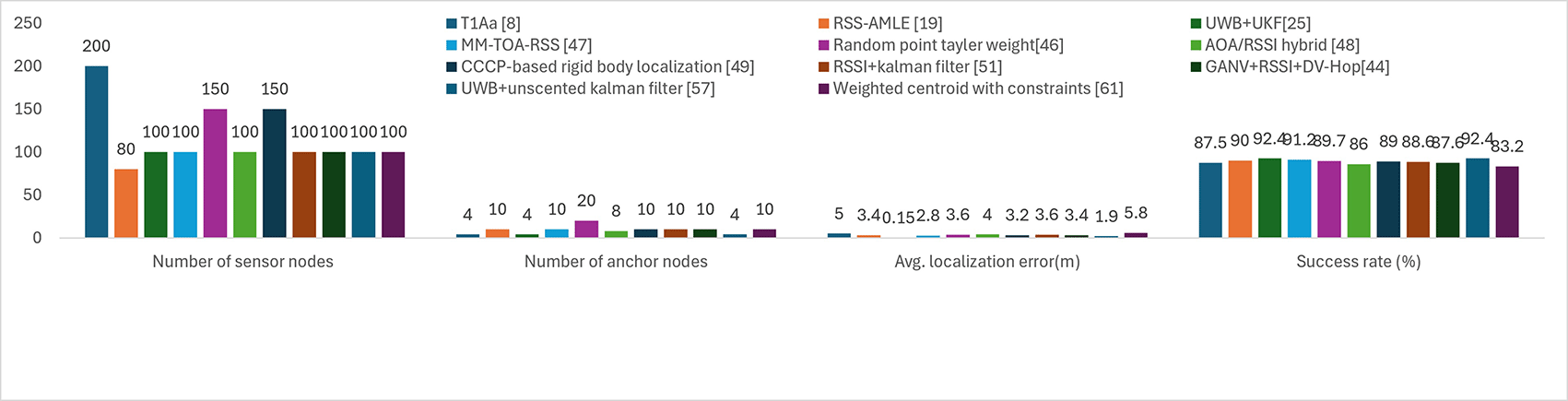
Filtering techniques such as Kalman filters (KFs), extended Kalman filters (EKFs), unscented Kalman filters (UKFs), and particle filters (PFs) are widely employed for tracking and noise mitigation. These methods are particularly effective for mobile and UAV-assisted WSNs, although their computational cost and energy consumption increase with network size and mobility. The use of adaptive filtering for noise reduction and tracking localization via 3D and mobile networks is a developing field, as both are applicable in UAV-based, airborne, and mobile WSNs. The techniques shown in Figure 8, such as T1Aa (TOA + AOA),8 HIPFF,45 and UWB + UKF,25,57 achieve success rates greater than 90% at the expense of energy consumption and increased computational cost. These methods are perfectly suitable for rescuing a disaster, battlefield monitoring and smart indoor infrastructure.
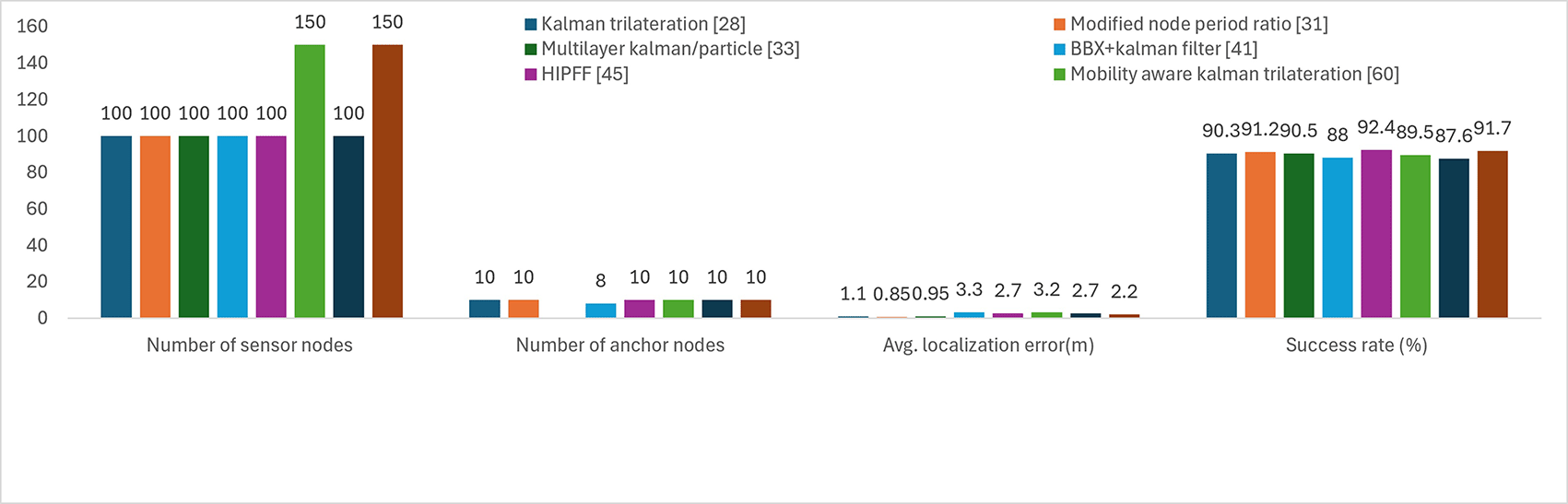
Anchor-light algorithms use a small set of anchor nodes, which lowers the infrastructure costs but still provides reference information for use in position estimation. In contrast to anchor-free approaches, which make no use of anchors at all, anchor-light approaches make use of few but strategically located anchors to increase accuracy. They are especially employed in problematic or sparse deployments, in which it is not possible to use many anchors, but a small number of reference nodes can be deployed. Anchor-light techniques offer a trade-off between cost, complexity and localization performance because they minimize the anchor dependence. Several hybrid algorithms are created that capitalize on the strengths of most disparate paradigms, as presented in Table 2.
| Algorithm | No. of Sensor nodes & Anchor nodes | Avg. localization error(m) | Energy consumption | Success rate (%) | Environment |
|---|---|---|---|---|---|
| Anchor-free geometric estimation21 | 100 | ~6.2 | Very low | 78.3 | Hostile |
| Lightweight region- based estimation22 | 100 | ~5.8 | Very low | 80.5 | Resource constrained nodes |
| Anchor-free iterative graph optimization32 | 100 & 10 | 2.9 | 0.82 | 83.0 | Ad hoc WSNs |
| Anchor free graph optimization64 | 200 | 4.9 | Low | 84.0 | Large scale WSN |
UAV-aided localization expands coverage and enhances geometric diversity in a three-dimensional environment. The latter are especially useful in terms of disaster recovery, military surveillance and inaccessible terrains. Although UAV-assisted approaches can greatly increase the precision, more energy, coordination, and optimization of trajectories are added. Examples include the UAV-assisted TOA/AOA hybrid T1Aa model for disaster and battlefield scenarios,8 mobile anchor schemes with altitude optimization for military and emergency deployments,24 the AFPA with virtual anchor projection for improved NLOS performance,42 and UAV-assisted TOA/RSSI localization for forested or collapsed environments,56 as shown in Table 3.
| Algorithm | No.of Sensor nodes & Anchor nodes | Avg. localization error(m) | Energy consumption | Success rate (%) | Environment |
|---|---|---|---|---|---|
| UAV - assisted 3D localization24 | 100 | 3.5 (open), 5.9 (urban) | High | 89.5 | 3D aerial with mobile anchors |
| UAV assisted 3D localization56 | 150 | 2.7 | High | 91.5 | 3D terrain |
| Modified savarese algorithm40 | 150 & 10 | 4.2 (indoor), 3.6 (outdoor) | Low | 85.5 | Mobile 3D WSN |
Certain localization methods are tailored for specific environments, such as underground mines, indoor industrial facilities, and urban canyons. Designed for specific deployment scenarios and environments. Certain localization solutions are tailored for specific application domains. The multicriteria decision-making (MCDM) framework helps select suitable algorithms on the basis of accuracy, cost, energy efficiency, and latency.57 The ZigBee-based localization shown in Table 4 has been deployed in underground coal mines where traditional communication systems fail.38 Hybrid tracking with Kalman filters adapts to LOS/NLOS transitions for mobile terminal localization,58 and probabilistic localization compatible with ZigBee balances accuracy with low power consumption for embedded IoT systems.65 Repeated information should not be reported in the text of an article. A calculation section must include experimental data, facts and practical development from a theoretical perspective.
| Algorithm | No. of Sensor nodes & Anchor nodes | Avg. localization error (m) | Energy consumption | Success rate (%) | Environment |
|---|---|---|---|---|---|
| Energy-aware iterative estimation20 | 200 & 15 | 5.6 | Low | 82.0 | Sparse anchor network |
| Clustered based hierarchical localization23 | 100 | 4.2 | Low-Medium | 87.0 | Harsh/NLOS terrain |
| ZigBee based WSN38 | 100 & 10 | ~6.0 | Moderate | 80.0 | NLOS |
The generalizability of the data in Table 5 shows that no single localization method is universally best; each involves trade-offs between accuracy, energy use and complexity. The optimal choice depends on application priorities and whether accuracy, efficiency or robustness in challenging environments is most critical. In brief, the compared models demonstrate that range-free methods save energy but lack precision, whereas range-based and optimized approaches improve accuracy at a higher cost. Hybrid and ML-driven models offer the best balance, and the optimal choice depends on the environment, mobility, node density and energy constraints.
Precision agriculture demands the correct localization of sensor nodes to enable an association of measurements of the environment with a particular location in the field. Differences in soil moisture, nutrients, and microclimatic conditions in farmlands necessitate spatial awareness to control irrigation and monitor crops. The hierarchical structure of the localization system provided by the wireless sensor network (WSN) is shown in Figure 9. First, the physical network layer, which is composed of sensor nodes located at varying positions in the target area, anchors nodes with known positions that are stationary, and finally, the base station device that collects the layout of deployments, which is well coordinated such that it has good coverage, connectivity stability and low power consumption.

The nodes continuously scan the environment and transmit relevant information wirelessly through the adjoining nodes or the base station itself; through the signal processing and measurement layer, the raw data, the signal strength, the arrival time or the connecting pattern, derived from the transmitted reception, are obtained. This is done to convert this phenomenon in the physical world to parameters in measurable parameters that can be used in positioning. Here, adjustments are made to address the issues arising because of interference from the environment, noise, fading, multipath reflection or barriers. All these processed measures are sent to the localization processing layer, which in turn takes the number of parameters and uses the same parameters to estimate the locations of unknown nodes. At this stage, network-wide positioning is computed through the premise of which anchor nodes and internode communications give the initial estimation of the locations. Processed data are then optimized in the data fusion and optimization layer, where data provided by various nodes, sensors, or even different types of measurements can be combined. Such integration decreases the ambiguity, rectifies potential inconsistency and increases stability. It is also possible to update the estimates dynamically when some nodes are mobile or when the environment changes with time. Moreover, the environmental adaptation and constraint layer runs concurrently to ensure that external conditions, such as signal blockage, weather impact, or network density, are monitored. This layer makes the system flexible enough to be adjusted on the flights to maintain accuracy and reliability without wasting energy resources unnecessarily. Thus, this case study discusses the influence of deployment geometry, anchor location and environmental constraints on the localization performance of agricultural sensor networks. In the following case study, the practical effects of the deployment geometry, NLOS barriers and positioning of the anchor on the localization performance are demonstrated. It is not intended as a benchmarking comparison of localization algorithms but is rather intended as an example of how real-world conditions affect the success of the localization strategies described in Section 2. This analysis, which was developed since visualizations were created with the help of Google Colab, allows this study to deeply examine the process of wireless sensor network deployment in three-dimensional spaces.
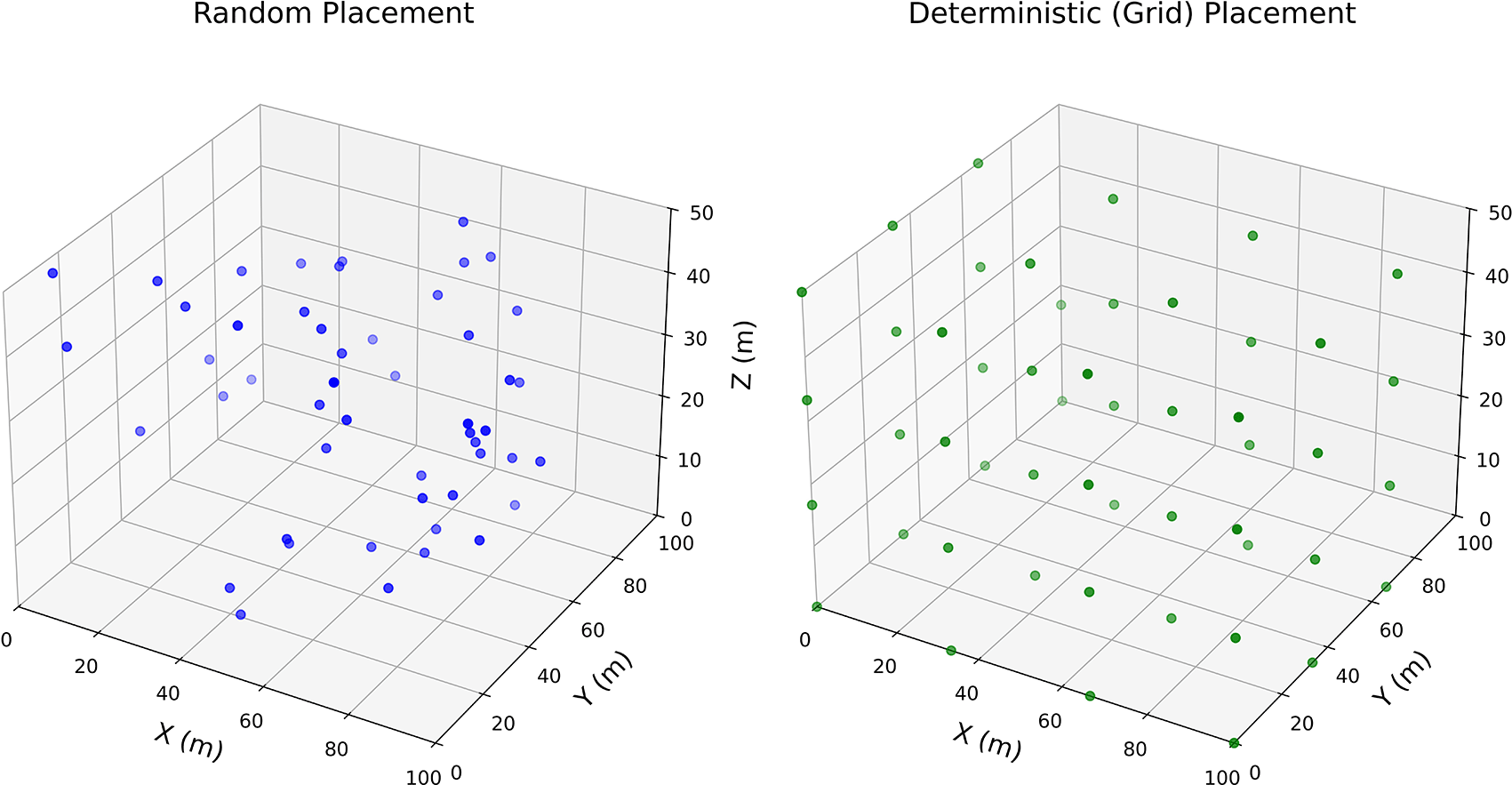
The network topology is composed of approximately 50 sensor nodes (encoded by blue circles) scattered at approximately 100 m, 100 m, and 50 m deployment regions and 5 anchor nodes (encoded by red triangles) placed strategically at the border of the network to support localization services.75
The core distinction between the random and deterministic grid-based methods of node placements in obstacle-free scenarios can be seen where random node deployment exhibits nonregular clustering behavior, whereas deterministic deployment provides equal spatial coverage in three-dimensional space. The visualizations are shown in Figure 10. Clearly illustrate the dramatic effects that node deployment strategies and the environment have on the performance of localization algorithms in wireless sensor networks (WSNs). Although it is more feasible in large distributions or unreachable locations, random deployment also leads to the generation of spatial artifacts that may impair localization precision. In contrast, deterministic placement is structured node placement, which is more accurate and simplifies the calculation of localization.
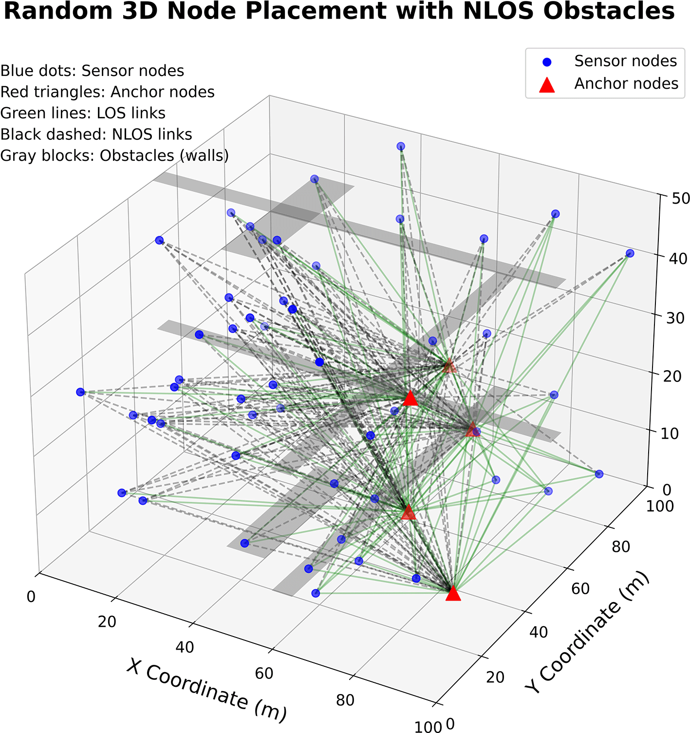
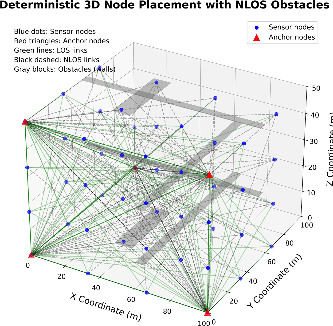
The scenario with NLOS (non–line-of-sight) obstacles indicates practical difficulties in real deployments of the network, as the gray rectangular obstacles strongly interfere with the node’s communication paths. In the random deployment with NLOS obstructions, the network has very fragmented connectivity with very long isolated nodes and random communication patterns, which can be seen in the few green lines. On the other hand, deterministic placement has more structured connectivity even despite obstacle interference, but in the current scenario, the performance of the network is highly dependent on environmental conditions. Anchor nodes with coordinates near (0, 0, 40), (0, 100, 20), (100, 0, 20), and (50, 50, 15) act as important reference points, which can be used by triangulation-based localization algorithms but operate much less efficiently in the presence of obstructions that hinder direct links between anchor nodes and sensor nodes (called non–line-of-sight (NLOS) obstacles).
Signal attenuation and path errors are caused by the introduction of non–line-of-sight (NLOS) obstacles, as indicated in Figure 11 and Figure 12, which proves to be a problem in traditional localization techniques. Thus, in practical cases, e.g., in an indoor 3D or obstacle-laden environment, it is necessary to develop hybrid algorithms that have the flexibility to cope with NLOS effects and can adapt to random and clustered node placements. Anchor nodes, strategic node planning and smart filtering (Kalman, particle filters) play important roles in implementing precise and defendable localization in an energy-efficient manner. In general, the simulations show the significance of deployment-aware and environment-sensitive localization methods for reliable WSN performance.
To validate the proposed distance-level adaptive hybrid localization framework, simulations were conducted in realistic precision agriculture scenarios in both two-dimensional (2D) and three-dimensional (3D) environments. The dimensions of the agricultural field were 100 m × 100 m (2D) and 100 m × 100 m × 20 m (3D), representing structured crop-row monitoring conditions. Sensor nodes were deployed using deterministic grid placement to emulate irrigation-controlled farmland. Five anchors were positioned at the field corners with an additional central anchor (elevated in 3D) to enhance spatial observability and reduce the geometric dilution of precision (GDOP). Vegetation-induced nonline-of-sight (NLOS) conditions were modelled using the log-normal path loss model:
Sensor positions were computed via nonlinear least-squares multilateration:
The additional vertical component increases the geometric sensitivity and error propagation in volumetric environments. 3.5 Compared with conventional position-level fusion, the proposed method performs measurement-level fusion prior to multilateration:
The average RMSE values received in the 2D case were as follows:
The mean RMSE values recorded in the 2-dimensional case of DV-Hop, RSSI and the proposed distance-level hybridized model were 43.67 m, 28.53 m and 24.24 m, respectively. The hybrid framework also decreased the localization error average in relation to the standalone RSSI approach by 28.53 m to 24.24 m, which is approximately 15% lower under the conditions of the assessment. The reported RMSE values are the average values of 50 Monte Carlo simulation runs, and the observed values of variations are the uncertainties due to attenuation of the environment, effects of NLOS and random deployment conditions. Compared with the other methods, the hybrid method has a consistently lower average RMSE under conditions of vegetation-induced attenuation, as shown in Figure 13.

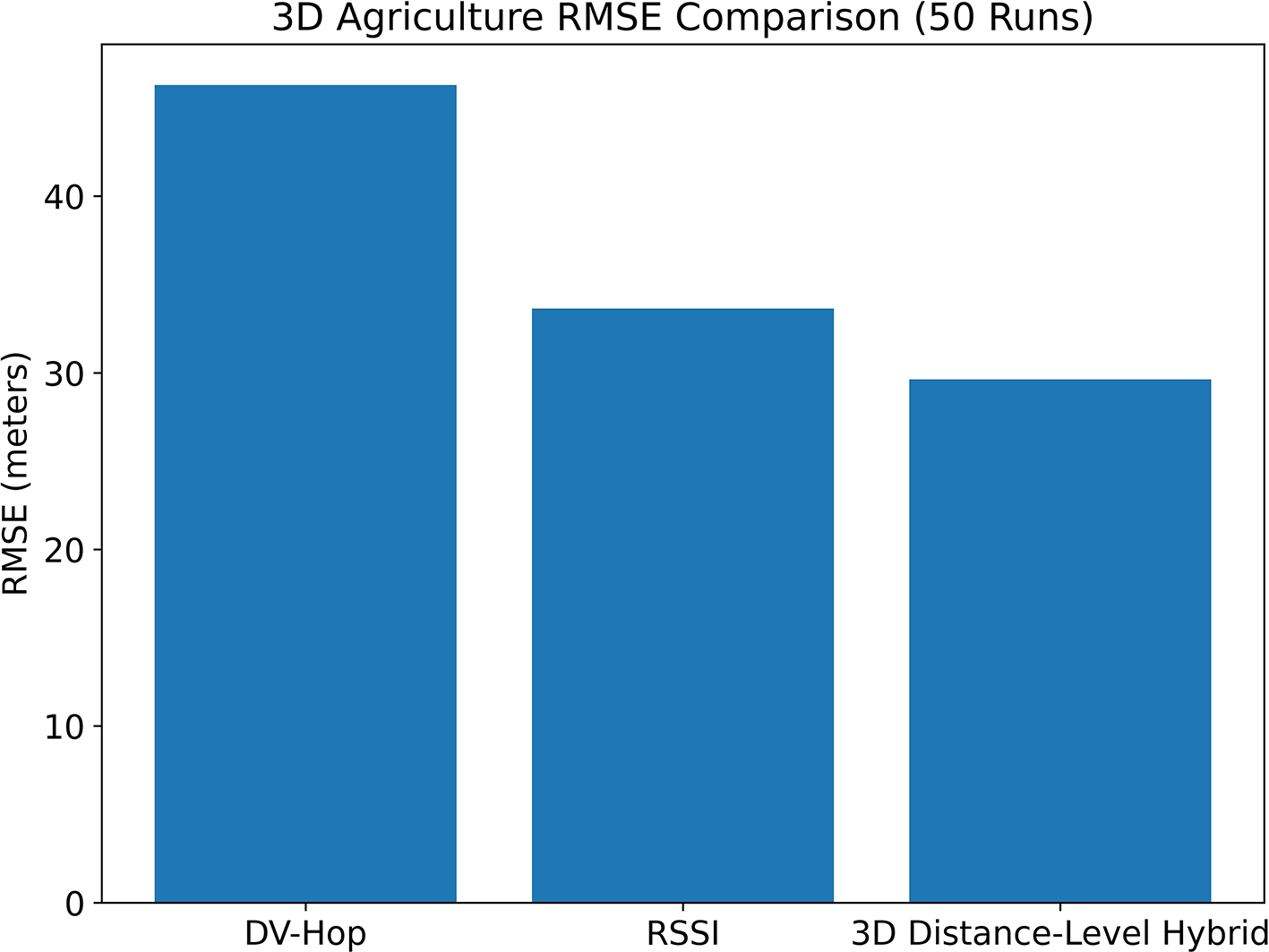
In the 3D case, the localization error increased with extended Euclidean geometry and vertical uncertainty. The values of the observed RMSE were as follows:
In the 3D scenario, the error of localization was greater because of the prolonged Euclidean geometry and extra uncertainty in the vertical dimension. The RMSE values were found to be 46.80 m in the case of DV-Hop and 32.83 m in the RSSI and in the distance-level hybrid approach, respectively. This is equivalent to a relative decrease of 10.4% in the mean localization error relative to that of the isolated RSSI in the simulated environment. The hybrid approach still yields a lower mean RMSE in the case of increased volumetric complexity, as demonstrated in Figure 14. The improvement is, however, less than that of the 2D method, which can be explained by the greater GDOP and vertical error propagation experienced in three-dimensional localization.
The findings prove the following three things:
1. The maximum error of the range-free DV-Hop is affected by the coarse geometry approximation.
2. RSSI-based multilateration is much more accurate; however, it is vulnerable to extreme NLOS.
3. The proposed distance-level hybrid fusion will continuously decrease the magnitude of error as well as the error variance in the 2D and 3D deployments. Even though dimensional expansion leads to overall error growth, the hybrid framework is easily scaled between planar and volumetric agricultural settings.
The results of these tests verify that the measurements eliminate vegetation-based distortion, improving the strength of localization with precision agricultural uses.
As this case study shows, the localization precision is not only reliant on the algorithm but also reliant on the following:
Random, NLOS-heavy, and hybrid localization approaches are required in random environments, and structured deployments can be effectively exploited by simpler approaches. These observations of deployment point to several real constraints of WSN localization, which are further elaborated in Section 4, and these include environmental impact, hardware, scalability, and energy usage.
Although the localization methodologies of wireless sensor networks have made tremendous advancements, various limitations associated with practical deployment still impact the accuracy, reliability and scalability. Uncertainties brought about by environmental considerations, hardware limitations, node movement and network density are not always well represented in simulation research. In this section, a summary of the significant challenges reported in the literature is presented, with a discussion of the effects these factors have on the performance of localization algorithms in practice.
WSN localization is a complex issue, especially when implemented in real-life scenarios when the environmental, hardware and implementation algorithmic limitations are combined. One of the common challenges is the existence of non–line-of-sight and multipath propagation, both of which greatly impair the performance of range-based methods.
Sensor nodes, in general, operate under battery power and localization algorithms based on intensive interactions, iterative methods, or power-consuming calculations (e.g., Kalman filters and swarm intelligence) using excessive energy.
Inadequate or insufficiently spaced anchors are the source of ambiguity and cumulative estimation error, particularly with large-scale or 3-dimensional deployments.
Scalability and real-time performance localization are complicated in dense or dynamic networks. Topology changes are very fast in mobile systems such as FANETs or UAV-aided 3D networks, and achieving precise localization through altitude estimation is also more challenging in mobile systems.
Many forms of optimization can include the GA, PSO, BWO and fuzzy logic, which often require close parameter optimization and can be sensitive to initial conditions. The hardware dependencies needed to achieve the AOA coupled with the synchronization requirements to perform the TOA/TDOA prevent high-precision techniques in environments that tend to be cost sensitive.
Most of these high-accuracy procedures, especially those that use metaheuristic optimization (e.g., the GA, PSO, BWO, and SSA), have convergence problems and high computational complexity. Despite their global optimization capabilities, they are not commonly used in applications where frequent updates are needed in limited time, such as autonomous navigation or emergency rescue missions. Efforts to reduce this effect via hybrid systems (e.g., PSO+ Kalman, or GA + RSSI) have proven fruitful thus far, yet they also lead to increased complexity of algorithm design, parameter adjustment and combination with other systems.
The accuracy of simulation environments might fail to capture some complexity of RF propagation, hardware failures, node heterogeneity, and environmental uncertainties. In summary, WSN localization has several issues, including the following:
1. NLOS and cancellation of the signal.
2. A large amount of energy is used.
3. Sparse or trotting anchor location.
4. Large or mobile network scalability and delay.
5. Tuning and overload due to computation.
6. Synchronization and hardware requirements.
The problems that are presented in this section are based on the parameters of the papers reviewed; however, the severity and relevance of the problem vary depending on the application. For instance, compared with energy constraints in agricultural and environmental settings, NLOS effects in indoor and underground environments are very important.
A survey is likely to provide feasible guidelines for the selection of suitable localization strategies in various deployment regimes. According to the literature reviewed, centroid and DV-Hop with the range-free method are suitable in agriculture and large outdoor sensor fields where energy efficiency is critical. The hybrid and optimization-based methods (e.g., the GA should be used with the PSO, DE, and SSA) are more accurate and can be used in the indoor and NLOS-dominated settings. The Kalman filter and particle filter, which are based on filtering, are more suitable for dynamic and tracking applications, as seen in military surveillance. TOA/TDOA approaches are suitable when the accuracy is high and when the support of synchronization is present. The next challenge is how to overcome these challenges through further development of hybrid localization frameworks, adaptive algorithms, energy-aware routing, and real-time optimization strategies to be applicable in IoT-based, smart city-based, and mission-critical domains. It is crucial to understand these issues to develop solid localization structures and encourage research directions, as discussed in the conclusion.
This literature review explored key localization methods of WSNs and their applicability to contemporary precision agriculture. Although range-free methods are simple, scalable, range-based, optimization-based, and hybrid methods are more accurate under challenging conditions. Complex 3D agricultural settings have high potential for use in ML-enabled and UAV-assisted solutions. A case study verified that deployment factors, such as anchor geometry, terrain elevation, and vegetation-related NLOS, significantly contribute to the localization result and that the measurement fusion hybrid can be strengthened. The main issues are still unresolved, such as the absence of uniform evaluation metrics, power restrictions, hardware virtuality, and environmental variability. In the future, WSN localization will evolve based on hybrid and adaptive approaches that combine signal-based measurements with lightweight machine learning to enhance resilience in dynamic and NLOS environments. Long-term operation will require energy-efficient designs with low-complexity computations based on duty cycling and energy harvesting. A dense IoT environment will need less communication overhead and more distributed edge processing to be scaled. Spoofing, Sybil attacks and RSSI manipulation are some of these threats that security-conscious localization should address. UAV- and mobility-based approaches will improve coverage in complex areas, whereas the use of standardized testbeds and standard evaluation protocols will be very important for reproducible and similar research results.
| Views | Downloads | |
|---|---|---|
| F1000Research | - | - |
|
PubMed Central
Data from PMC are received and updated monthly.
|
- | - |
Provide sufficient details of any financial or non-financial competing interests to enable users to assess whether your comments might lead a reasonable person to question your impartiality. Consider the following examples, but note that this is not an exhaustive list:
Sign up for content alerts and receive a weekly or monthly email with all newly published articles
Already registered? Sign in
The email address should be the one you originally registered with F1000.
You registered with F1000 via Google, so we cannot reset your password.
To sign in, please click here.
If you still need help with your Google account password, please click here.
You registered with F1000 via Facebook, so we cannot reset your password.
To sign in, please click here.
If you still need help with your Facebook account password, please click here.
If your email address is registered with us, we will email you instructions to reset your password.
If you think you should have received this email but it has not arrived, please check your spam filters and/or contact for further assistance.

Comments on this article Comments (0)