Keywords
Domestic cat, citizen science, prey returns, GPS tracking, movement ecology, anonymisation, Denmark
Domestic cat, citizen science, prey returns, GPS tracking, movement ecology, anonymisation, Denmark
Domestic cats (Felis catus) are among the most widespread mammalian predators in human-modified landscapes and occur at high densities across urban, suburban, and rural environments. Their predation has been quantified using several methods, including prey returns brought back to households, direct observation, and animal-borne sensors, each of which captures different components of hunting behaviour (Woods et al., 2003; Loyd et al., 2013). Consequently, domestic cats have become a prominent focus in ecological and conservation research, spanning individual-level behavioural variation to regional estimates of wildlife mortality (Loss et al., 2013).
Many studies quantify cat predation using owner-reported prey returns, typically recording prey items brought home. This approach enables large sample sizes and has been widely used in participatory and citizen science contexts, where volunteers contribute observations at scales that would otherwise be difficult to achieve (Bonney et al., 2009; Woods et al., 2003). However, prey-return data are known to represent an incomplete sample of prey captured, as cats may consume prey or abandon it at the capture site, leading prey-return-based studies to underestimate total captures (Loyd et al., 2013). Prey returns are therefore best interpreted as measures of “prey return” behaviour rather than direct measures of kill rates, and their strengths lie in comparative and individual-level analyses where consistent protocols are applied.
In parallel, lightweight GPS devices have enabled analyses of domestic cat movement, home-range use, and habitat associations (e.g. Jensen, et al. 2022, Pyott et al. 2024). Such tracking data can complement prey-return records by quantifying space use and activity patterns and by helping explain why individuals differ in encounter rates with potential prey. Movement ecology has advanced rapidly with miniaturised tracking technologies and standardised data infrastructure, creating new opportunities for comparative analyses and reproducible research (Kays et al., 2015; Kays et al., 2022). Recent GPS-based studies show that even cats with relatively small home ranges can exert substantial local ecological impacts (Kays et al., 2020) and that home range size varies widely with sex, habitat, and management practices (Hall et al., 2016). Similar approaches have recently been used to estimate population size and distribution of unowned free-ranging cats in Denmark using questionnaires paired with GPS-based home-range estimation (Nielsen et al., 2022)
We present a dataset originating from a volunteer-based study conducted on Funen (Fyn), Denmark, between 2014 and 2015, which we used to link prey-return observations, questionnaire-based metadata, and GPS tracking for a subset of cats. In this Data Note, we describe the structure, provenance, anonymisation procedures, and validation of the publicly released dataset to support transparent reuse.
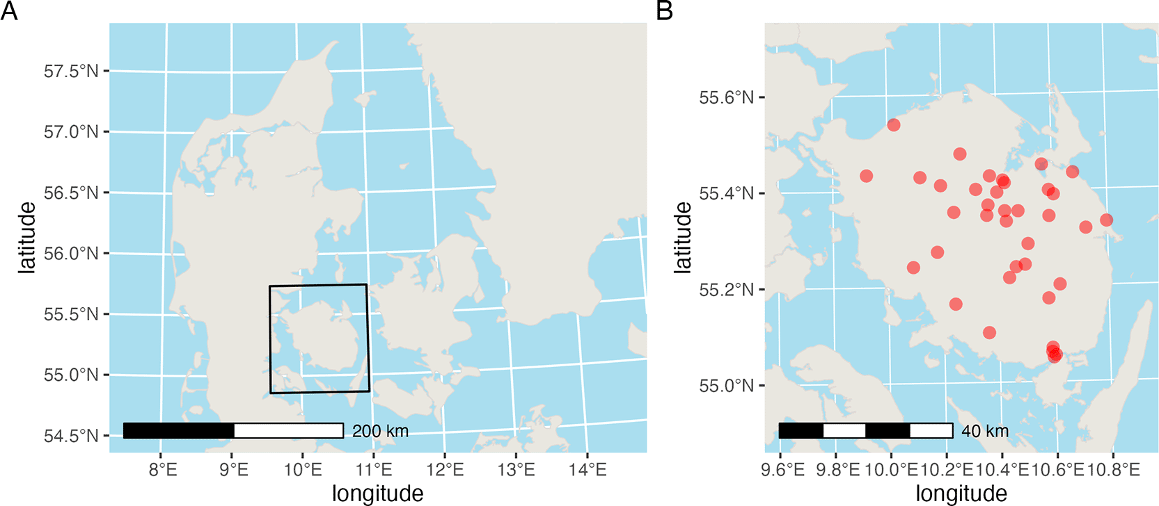
We designed the study as a volunteer-based observational programme involving domestic cat owners on Funen, Denmark. We recruited participants through advertisements in local newspapers and online platforms, aiming to reach households across a broad urban–rural gradient ( Figure 1). The recruitment materials emphasised contributing to research on cat behaviour and hunting, and participation required owners to report prey returns and complete questionnaires. Volunteer-based designs of this kind are commonly used to gather large quantities of ecological observations while engaging the public in scientific data collection (Bonney et al., 2009).
Participation comprised three components: (i) questionnaire-based metadata at the cat and household levels, (ii) reporting of prey returns using a standard protocol, and (iii) optional GPS tracking for a subset of cats. Table 1 summarises the main data components included in the public release. We asked owners not to change their routine management practices (e.g., feeding, outdoor access) in response to participation, to minimise behaviour change induced by observation. This instruction aimed to support ecological validity, although adherence cannot be guaranteed and remains a common limitation in observational studies of domestic animals.
We collected questionnaire data covering cat demographics, household context, and selected management variables. Cat-level fields included age, sex, neuter status, household composition (including multi-cat households), and other variables recorded under the original study protocol. Household-level fields captured coarse environmental context and descriptors relevant to the cat’s living situation, which we designed to support comparisons across habitat categories. Questionnaire-based metadata are frequently used in cat predation studies to relate hunting behaviour to individual traits and owner practices (e.g., Woods et al., 2003; van Heezik et al., 2010). Table 2 lists the key variables included in the main data tables.
We cleaned, standardised, and translated responses into English-facing values for public release. We assigned each cat and household a stable pseudonymous identifier (cat_uid, house_uid), enabling linkage across prey records, metadata tables, and tracking data while preventing disclosure of direct identifiers. We organised the release so that cat- and house-level metadata appear in distinct tables to support tidy joins and clear modelling structures. We propagated house-level covariates consistently across cats sharing a household to avoid within-house conflicts in household attributes.
We collected prey records from November 2014 to October 2015 using a “what the cat brought home” protocol, in which owners recorded prey items returned to the household by their cats. During the initial phase of the study, owners submitted photographs and survey entries documenting prey items; from February 2015 onward, we collected physical specimens where feasible, alongside photographic documentation. We instructed owners to photograph prey against a standardised background with a printed scale and to provide multiple angles where possible, to support identification and measurement.
When collected, we placed physical specimens in labelled bags and froze them for later examination. These steps were intended to improve taxonomic resolution and measurement consistency while keeping data collection feasible for volunteers. Prey-return approaches are widely used in cat predation studies because they are practical at scale, but they should be interpreted with caution given the known underestimation of total captures (Woods et al., 2003; Loyd et al., 2013).
We identified prey items using visual determination keys and expert guidance. Where possible, we measured and weighed physical specimens before identification, and we recorded diagnostic morphological features. When species-level identification was not possible because of decomposition, partial remains, or insufficient photographic detail, we classified prey at higher taxonomic levels. This is common in prey-return datasets and reflects the realistic constraints of volunteer-collected observations (Woods et al., 2003).
For the public release, we harmonised taxonomic information across records to provide consistent fields for common names, Latin names (where available), and broad prey classes. This harmonisation supports reuse by enabling aggregation at multiple taxonomic levels and facilitating integration with trait or biodiversity resources. We processed catch records with unresolved cat labels (e.g., “unknown” entries reassigned within known households) deterministically, and we represent them fully in the released catch table via pseudonymised cat_uid linkage. The dataset therefore supports analyses ranging from coarse prey-class summaries to finer taxonomic comparisons where identification permits.
We categorised household habitat into urban, suburban, and rural classes according to the original study protocol. These classes were defined using simple criteria based on proximity to nearby buildings and open land, which we intended to capture broad gradients in built density and landscape context. Coarse habitat categorisations of this kind have been used in previous studies to compare cat behaviour and prey returns across human-dominated landscapes (van Heezik et al., 2010). The categories are intended for broad comparative analysis rather than fine-scale habitat modelling.
We assigned habitat categories using a combination of participant information and map-based checks, consistent with the study’s original methods. We provide a separate derived table with household-level land-use summaries for a subset of households, linked via the provided join key. Together, these variables support exploratory analyses of how hunting and movement relate to the broader habitat context.
We equipped a subset of cats with CatTrack1 GPS trackers for approximately one month in May–June 2015. We selected individuals to balance age, sex, habitat category, and perceived hunting activity, subject to practical constraints such as device availability and owner willingness. As in many volunteer-based studies, we could not implement purely random sampling, and this should be considered when interpreting population-level movement summaries. Nevertheless, GPS data provide high-resolution movement trajectories that are valuable for within-study comparisons and individual-level analyses.
GPS devices recorded location fixes at regular intervals, producing fine-scale movement tracks. We filtered the data to remove obvious artefacts, and we stored tracks as per-cat files in the repository. We represented two cats with clearly separated movement clusters as site-specific tracking identities (with suffixes: _2) to preserve analytical structure without implying additional biological individuals. We made this relationship explicit in the anonymised identifiers (for example, cat_007 and cat_007_2). The release is organised to support standard movement ecology workflows while acknowledging practical limits in sampling and device deployment.
Where missing values could be resolved deterministically from auxiliary information or internal consistency rules, corrections were applied during private preprocessing and are reflected in the release-ready data. We performed data cleaning, harmonisation, anonymisation, and the generation of public summaries using scripted R workflows (R version 4.5.2 (2025-10-31), R Core Team (2025)). We version-controlled all release-facing analysis steps in the public repository, while internal preprocessing workflows are maintained separately.
The processing workflow produces both public-facing cleaned tables and derived summaries for reports and illustrative analyses. We encoded filtering, aggregation, and transformation parameters in scripts to reduce ambiguity in reproduction. Users can rerun the core public workflow using the runner script described below and then extend analyses using the provided cleaned tables.
We designed anonymisation procedures to balance analytical utility with participant privacy, particularly because raw GPS tracks were centred on private residences. It is widely recognised that GPS location data can be sensitive and may require modification or reduced resolution for safe sharing (Kays et al., 2022; Lennox et al., 2020). We therefore replaced cat and household identifiers with stable pseudonyms (cat_uid, house_uid) before release, and we removed all direct identifiers, including names, addresses, and private mapping keys.
We anonymised GPS coordinates using a household-specific rigid spatial transformation comprising a rotation and a translation, applied uniformly to all fixes belonging to a given household. Figure 2 illustrates transformed GPS tracks for selected cats. For each house_uid, we generated a single transformation and applied it consistently to all associated GPS records. As a result, every GPS point recorded for cats from the same household was rotated by the same randomly chosen angle and then shifted by the same fixed horizontal and vertical offsets.
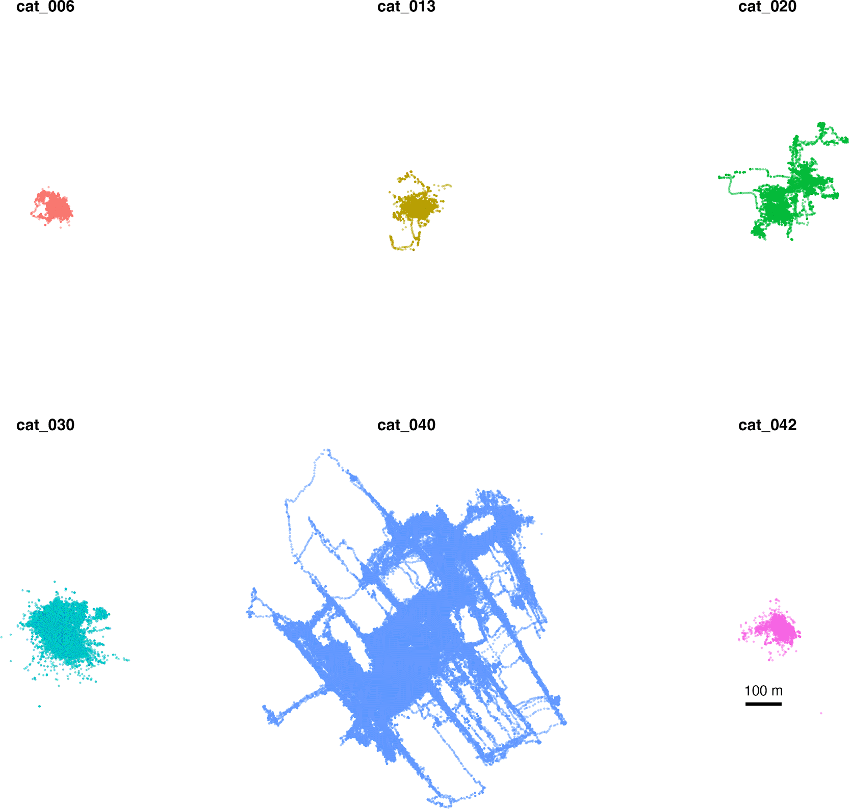
Points are anonymised using a household-specific rigid transform (rotation + translation). Relative geometry is preserved, while absolute location is removed.
For each household, we computed the transformation in projected coordinates (EPSG:25832) using a rigid transform. We applied a household-specific random rotation to the original coordinates, followed by a random translation with displacement sampled uniformly between 500 and 2,000 m. We applied the same rotation and translation to all GPS fixes associated with that household. We introduced no scaling, stretching, non-rigid warping, or pointwise random noise. In the released dataset, the resulting household-level displacements ranged from 556 m to 1,974 m, with a median of 1,272 m.
As a result, we preserved all relative spatial properties within a household’s tracking data (see Figure 2). Distances between fixes, movement paths, step lengths, turning angles, and the relative positions of frequently used areas remain unchanged after transformation, up to rotation and translation. Home-range estimates, utilisation distributions, and movement metrics derived from the transformed coordinates therefore correspond directly to those obtained from the original coordinates, except for orientation and absolute position.
We generated the random rotation angles and translation offsets within the internal processing workflow and did not include them in the public release. Consequently, users cannot reverse the transformation to recover true geographic locations from the released data. This ensures that transformed tracks cannot be linked to identifiable residential locations using publicly available spatial information.
This approach preserves the internal geometry of movement trajectories while preventing geographic re-identification. It is conceptually similar to geomasking approaches for sensitive spatial data, but differs in preserving full within-household spatial structure rather than introducing positional noise or spatial jitter.
We note that, because absolute geographic reference is removed, transformed coordinates cannot be used to map onto external spatial layers using real-world locations. Analyses requiring true spatial context should therefore rely on the derived summaries provided in the repository rather than the transformed point coordinates.
We run the public release analysis workflow using a single runner script (scripts/01_run_analysis.R), which sources the core analysis scripts and renders reproducible summary, descriptor, and illustrative reports. The runner executes self-contained analyses using only released data and documented dependencies. Internal preprocessing and release-preparation steps are conducted separately prior to archiving and are not required to reproduce the published analyses and reports. Some spatial context outputs in results/ and derived/are provided as precomputed artefacts, because full recomputation would require private inputs and/or external services not included in the public package. This structure follows good practice for reusable research compendia by separating raw and derived products, documenting join keys, and including runnable analysis code.
The repository also includes HTML summaries and illustrative analyses that are generated from R Markdown source files and rendered as part of this public workflow. These materials help users quickly understand the dataset’s structure and common analytical entry points, thereby lowering the barrier to reuse and reducing the risk of misinterpreting key variables. Users can use the provided scripts and report templates as starting points for model fitting, data aggregation, and reporting when extending the work.
Stable identifiers enable us to link catch records, metadata tables, and GPS summaries reproducibly. We verify these links through automated joins in the workflow, which check that prey records map to valid cat identifiers and that cats map to valid household identifiers. We document record counts, temporal coverage, and categorical distributions in summary reports, providing baseline consistency checks that users can reproduce locally. These checks are particularly important in multi-table ecological datasets, where silent key mismatches can propagate into analyses. Where missing values could be resolved deterministically from auxiliary information or internal consistency rules, corrections were applied in the private preprocessing stage. The released data reflect these harmonised values
We validated core cross-table joins during preprocessing and structured the public release to preserve cleaned linkage patterns from the source data. Remaining mismatches should be interpreted as properties of the underlying volunteer-collected inputs rather than public-release processing errors.
The rigid transformation we applied to GPS coordinates preserves the relative movement geometry within households. We validated the transformed data by inspecting coordinate ranges, sequencing statistics, and movement summaries (e.g., step-length distributions) to ensure a plausible track structure. These checks confirm that the transformation did not introduce artefactual movement patterns, while recognising that absolute geographic interpretation is intentionally removed. The dataset is therefore suitable for analyses of relative space use and movement dynamics, but not for mapping to true landscape features at a fine scale.
The public descriptor includes summary statistics that users can compare with their own recomputations. This also serves as a practical check that the runner script executes correctly in a new environment. Together, these materials support confidence that the released tracking data are internally coherent and analytically usable.
The repository includes illustrative analyses demonstrating model fitting and summary outputs using only the public release. Examples include mixed models of weekly prey-return counts and repeatability estimates for individual differences in prey returns. These analyses are intended as worked examples rather than definitive ecological conclusions, and they are written to be neutral and reusable. As such, they provide both a template for typical analyses and functional validation that the released tables support common workflows.
Illustrative analyses also clarify how key fields should be interpreted (e.g., what constitutes a “catch record”, how time aggregation was performed, and how cats were nested within households). Because these examples are executable, they are also useful checks for any future updates to the repository. Users can build on these scripts to explore alternative models or derive new summaries.
Prey returns are an incomplete sample of total predation and should be interpreted as indices of prey-return behaviour rather than direct measures of total kill rates. Video-based studies have shown that a substantial proportion of captured prey may be consumed or left at the capture site rather than returned home (Loyd et al., 2013). Taxonomic resolution varies with protocol adherence and prey condition, which is typical of owner-reported and photograph-based records (Woods et al., 2003). We did not select GPS-tracked cats purely at random, which limits population-level inference for movement metrics, although within-study comparisons and individual-level analyses remain well supported.
This study involved human participants (cat owners) and non-experimental observation of privately owned domestic cats.
We collected data from volunteer cat owners who provided informed consent to complete questionnaires, report prey returns, and, optionally, participate in GPS tracking. Consent was obtained in writing at enrolment. All participation was voluntary, and participants retained full control over their involvement and the right to withdraw at any time. The study was conducted in accordance with the principles of the Declaration of Helsinki.
The study was non-invasive and primarily observational, involving adult participants. Under Danish law, the mandatory notification to the scientific ethics committee system applies to health research projects under the Danish Committees Act (Komitéloven). Questionnaire-based studies are subject to notification only if human biological material is collected. As no human biological material was collected in this study, notification or approval under Komitéloven was not required.
The animal component of the study consisted solely of observational, non-experimental fieldwork, with the temporary attachment of CatTrack1 GPS trackers to privately owned domestic cats, with explicit owner consent. No experimental procedures were performed. In Denmark, authorisation is required for regulated animal experiments overseen by the Animal Experiments Inspectorate; this study did not constitute an animal experiment requiring such authorisation. Study procedures were designed to minimise burden and welfare risk, with owner oversight and removal of trackers if any concerns arose.
Personal data were processed in accordance with the EU General Data Protection Regulation (GDPR) and the Danish Data Protection Act, following institutional guidance. To protect participant privacy, we removed direct identifiers, pseudonymised records, and applied spatial transformations to reduce the risk of re-identification in the public data release. Guidance on ethics and integrity in citizen science emphasises the importance of informed consent and careful handling of personal data when participants may be identifiable (Bonney et al., 2009; Ozolinčiūtė et al., 2022). Although the ecological risk profile of this study is low, household-linked GPS movement data can be inherently sensitive, as they may reveal the locations of private residences if not obfuscated. Our anonymisation approach aligns with broader recommendations that potentially sensitive movement data may require modification or controlled resolution prior to public release (Lennox et al., 2020; Kays et al., 2022).
| Views | Downloads | |
|---|---|---|
| F1000Research | - | - |
|
PubMed Central
Data from PMC are received and updated monthly.
|
- | - |
Provide sufficient details of any financial or non-financial competing interests to enable users to assess whether your comments might lead a reasonable person to question your impartiality. Consider the following examples, but note that this is not an exhaustive list:
Sign up for content alerts and receive a weekly or monthly email with all newly published articles
Already registered? Sign in
The email address should be the one you originally registered with F1000.
You registered with F1000 via Google, so we cannot reset your password.
To sign in, please click here.
If you still need help with your Google account password, please click here.
You registered with F1000 via Facebook, so we cannot reset your password.
To sign in, please click here.
If you still need help with your Facebook account password, please click here.
If your email address is registered with us, we will email you instructions to reset your password.
If you think you should have received this email but it has not arrived, please check your spam filters and/or contact for further assistance.
Comments on this article Comments (0)