Keywords
Deep learning, agroforestry, forest degradation, Ethiopia, hyperspectral remote sensing, PRISMA, REDD+, remote sensing, deforestation, carbon stock
This article is included in the Artificial Intelligence and Machine Learning gateway.
This article is included in the Agriculture, Food and Nutrition gateway.
Deep learning, agroforestry, forest degradation, Ethiopia, hyperspectral remote sensing, PRISMA, REDD+, remote sensing, deforestation, carbon stock
Agroforestry systems in Ethiopia represent a cornerstone of rural livelihoods, biodiversity conservation, and ecosystem resilience. These systems include coffee-based shade agroforestry, Eucalyptus woodlots covering approximately 506,000 hectares (90 percent of all planted trees), and parkland systems dominated by species such as Faidherbia albida.1 Ethiopian highlands constitute 45 percent of the nation’s land area and host complex mosaics that face severe pressure from population growth, smallholder agriculture, and climate stress. In Dedo District (Oromia Region), forest cover declined by 67.21 percent (859.5 hectares) between 1990 and 2022.2 Similar degradation patterns are documented in the Amhara Region and SNNPR.3,4
Traditional remote sensing using Landsat (30 m) or MODIS (250 m) lacks the spatial granularity to detect early degradation signals (selective logging, canopy thinning) in plots smaller than 0.5 hectares. Deep learning architectures—Convolutional Neural Networks, Attention U-Net, recurrent networks, and transformers—combined with very high-resolution imagery (Planet NICFI 3–5 m, WorldView 2 m) and emerging hyperspectral data (PRISMA, 234 bands) now enable sub-meter tree-crown detection and species-level discrimination.5,6,7
No prior systematic synthesis integrates multispectral deep learning with hyperspectral applications in Ethiopian agroforestry contexts. This review addresses four research questions: (1) Which deep learning architectures are used for forest dynamics monitoring? (2) What accuracy levels are achieved for degradation versus deforestation? (3) What are the primary data, computational, and ecological barriers? (4) How can deep learning outputs inform Ethiopia’s REDD+ framework?
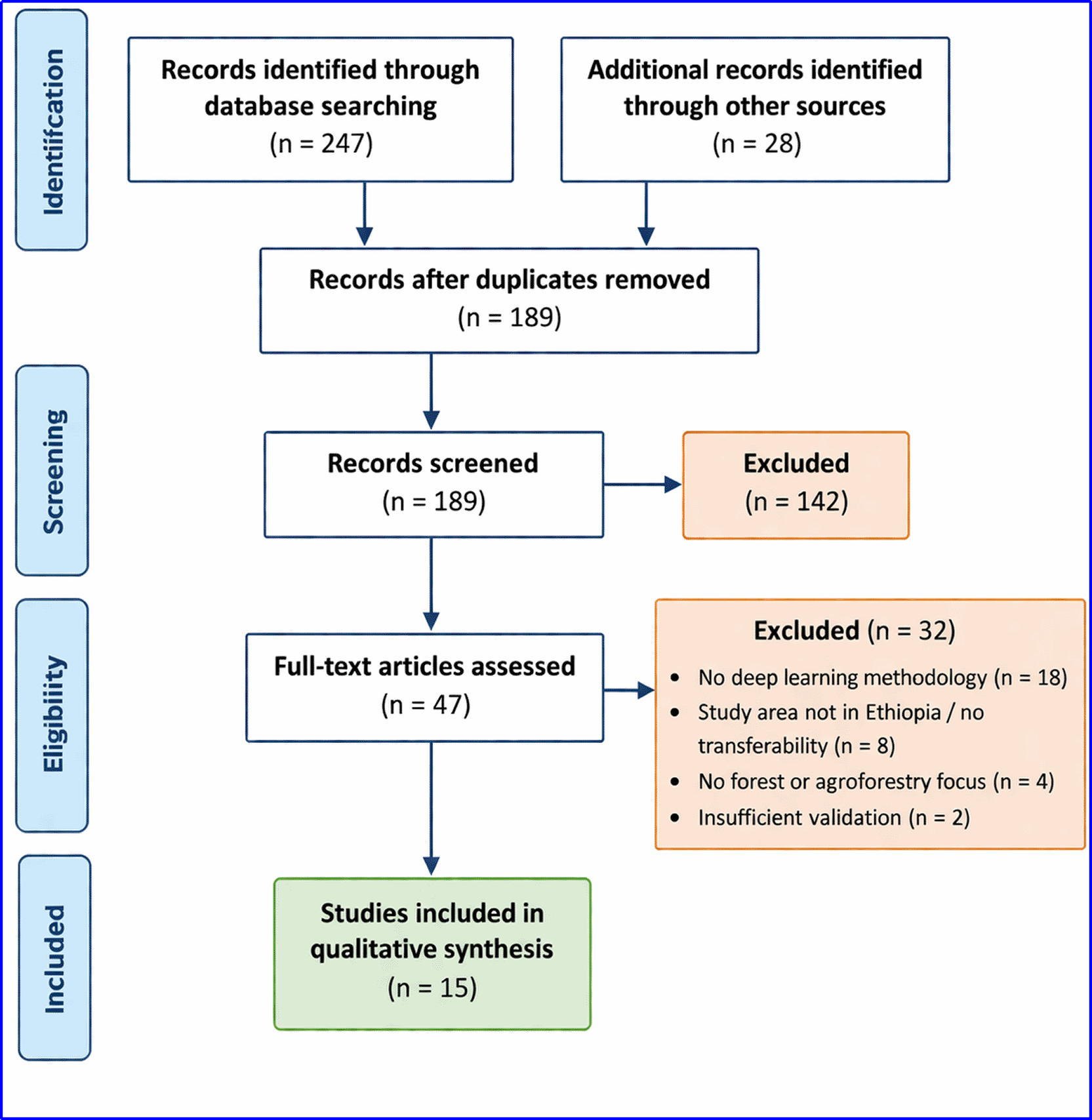
This review follows PRISMA 2020 guidelines.8
Studies were included if they met all of the following criteria: peer-reviewed article, conference proceeding, or preprint published between 2018 and March 2025; written in English; study area wholly or partially within Ethiopia or presenting methods directly transferable to Ethiopian agroforestry with explicit discussion of transferability; methodology employing deep learning (neural networks with at least three hidden layers, including CNN, U-Net, Attention U-Net, RNN, or transformers); or using hyperspectral data for forest applications even if classical machine learning served as baseline. Tasks addressed tree cover mapping, forest degradation, deforestation detection, land use following deforestation, or biomass estimation. Validation required ground truth data, very high-resolution imagery, or independent field plots.
Studies were excluded if the study area lay entirely outside Ethiopia without transferability discussion, if only classical machine learning (Random Forest, SVM) was used without deep learning component (except PRISMA baseline comparisons), if focused solely on plantation forests without agroforestry context, or if the study was a review without original analysis.
Databases searched on 15 March 2025 included Scopus, Web of Science Core Collection, Google Scholar (first 300 results), NASA Astrophysics Data System, and Semantic Scholar. The search string combined deep learning terms (deep learning OR convolutional neural network OR CNN OR U-Net OR Attention U-Net OR transformer OR RNN OR LSTM OR 1D CNN), forest dynamics terms (forest degradation OR deforestation OR tree cover loss OR agroforestry OR land use following deforestation OR forest dynamics), Ethiopian geographic terms (Ethiopia OR Ethiopian highlands OR East Africa OR Oromia OR Amhara OR SNNPR), and sensor terms (Sentinel-2 OR Landsat OR Planet OR WorldView OR UAV OR PRISMA OR hyperspectral). Targeted searches focused on hyperspectral literature and key authors.1,3,9,10
Two independent reviewers performed title/abstract screening followed by full-text review. Disagreements were resolved by a third reviewer. From 247 database records plus 28 additional records from targeted searches and snowball sampling, 189 unique records remained after duplicate removal. Title/abstract screening excluded 142 records. Full-text assessment of 47 records excluded 32 (18 no deep learning, 8 no Ethiopia/transferability, 4 no forest/agroforestry focus, 2 insufficient validation). Fifteen studies were included.
A standardized extraction form captured author/year, architecture, sensor/resolution, study region, agroforestry type, task, accuracy metrics, validation method, and code/data availability. Risk of bias was assessed via modified PROBAST tool across three domains: participant selection (spatial sampling), predictors (data preprocessing), and outcome (ground-truth quality). Qualitative synthesis was performed due to methodological heterogeneity.
Publication activity showed a clear and sustained acceleration over time, indicating growing scientific and policy interest in the topic. Only one study was published during the early period of 2018–2020, followed by a moderate increase to four studies between 2021 and 2022. This upward trajectory became more pronounced in the most recent period, with ten studies produced between 2023 and March 2025, reflecting both improved research capacity and heightened relevance of the subject area ( Table 1).
| Author and year | Architecture | Sensor and resolution | Study area | Task | Accuracy/Key metric |
|---|---|---|---|---|---|
| 9 | Attention U-Net | Planet NICFI (3–5 m), Sentinel-2 (10 m), Landsat (30 m) | Ethiopia deforestation hotspots | Post-deforestation LULC (11 classes) | 85–89% |
| 11 | CNN + RNN | Landsat time series (30 m) | Pan-tropical incl. Ethiopia | Post-deforestation trajectories | Comparable to 2022a |
| 7 | CNN | PRISMA hyperspectral (30 m, 234 bands) | Southern Italy | Tree species classification | >90% |
| 12 | 1D-CNN | PRISMA hyperspectral (30 m) | Amazon | Deforestation & degradation | 94% def., 92% deg. |
| 10 | MLP neural network | Sentinel-2 time series (10 m) | Ethiopian coffee agroforestry | Degradation detection | 80–85% |
| 3 | U-Net CNN (transfer) | WorldView (2 m), Sentinel-2 | Amhara Region | LULC classification | >90% overall, >95% trees |
| 1 | ANN (RF benchmark) | Sentinel-2 (10 m) | Akaki catchments | Eucalyptus woodlot mapping | ANN 88.7%, RF 96.3% |
| 13 | Random Forest | GEDI + Sentinel-1/2 + SRTM | Northwestern Ethiopia | Canopy height/cover | R2 0.86 height, 0.87 cover |
| 2 | Random Forest | Landsat 5/8 (30 m) | Dedo District, Oromia | Forest cover dynamics | 67.21% decline |
| 14 | Random Forest (GEE) | Sentinel-2 time series | Sheka Zone | Highland bamboo mapping | Validated |
| 15 | SVM & RF (GEE) | Landsat (30 m) | Abelti Watershed | LULC change | SVM vs RF |
| 16 | Spectral Angle Mapper | Field hyperspectral | Yeraba plantation | Age & species mapping | Successful discrimination |
| 6 | Baseline | PRISMA (30 m) | Italy | Forest-type discrimination | PRISMA > Sentinel-2 |
| 17 | SVM/KLR/NBT | Optical | Transferable | Forest cover change | Methodological benchmarks |
| 18 | Non-DL | Optical + field | Lake Abaya | Restoration impact | Erosion reduction linked |
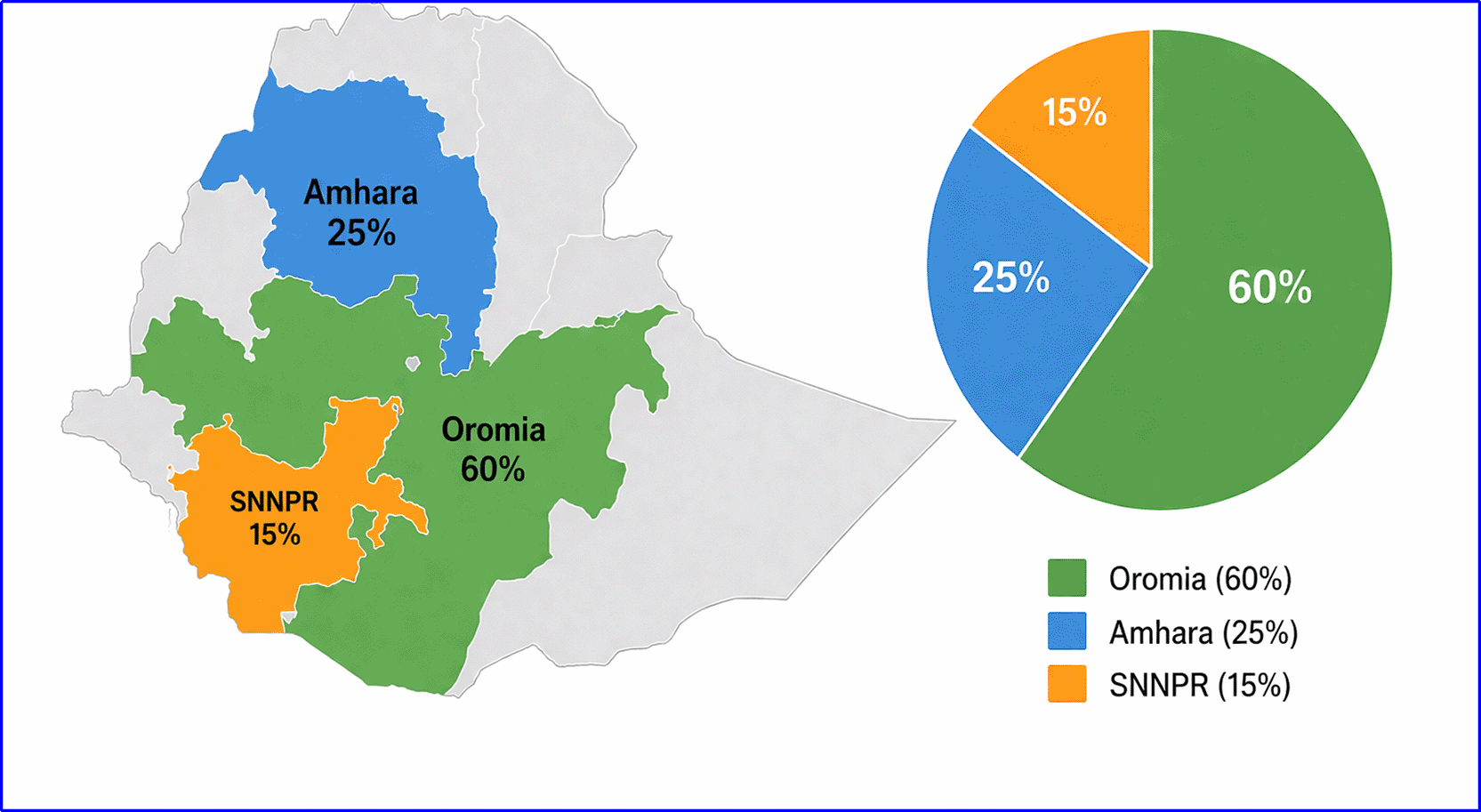
Geographically, the distribution of studies was uneven and highly concentrated in a few regions. Oromia accounted for the majority of studies (60 percent), with a strong focus on coffee-growing landscapes and specific hotspots such as Dedo District, which are known for their agroforestry systems and biodiversity significance. Amhara contributed 25 percent of the studies, primarily centered on the Lake Tana basin and the northwestern highlands, areas characterized by mixed farming systems and important watershed functions. The remaining 15 percent of studies were conducted in the Southern Nations, Nationalities, and Peoples’ Region (SNNPR), particularly within the Sheka Zone, where bamboo forests and forest-based livelihoods dominate ( Table 1).
In contrast, there was a complete absence of studies from several regions, including Somali, Afar, and Gambella, highlighting a significant geographic research gap. These underrepresented areas differ markedly in ecology and land-use systems, suggesting that current evidence may not fully capture national-scale variability ( Table 1).
Attention U-Net on Planet NICFI fused data achieved 85–89 percent accuracy for post-deforestation classification into 11 classes, with attention mechanisms effectively handling smallholder agrofrestry plots.9 Recurrent-convolutional models improved temporal trajectory detection.11 PRISMA with 1D-CNN reached 94 percent for deforestation and 92 percent for degradation detection, transferable due to consistent spectral signatures.12 In analogous forest landscapes, PRISMA-CNN exceeded 90 percent for species classification by resolving biochemical traits.7,6 In Ethiopian coffee agrofrestry systems, MLP networks on Sentinel-2 detected degradation at 80–85 percent, limited by spectral mixing.10 Transfer learning from Senegal achieved >90 percent in Amhara.3 Random Forest benchmarked at 96.3 percent for Eucalyptus mapping1 and provided strong multi-sensor canopy models.13
Agricultural expansion and rapid population growth were identified as the primary drivers of forest loss in Dedo District, accounting for approximately 67.21 percent of the observed deforestation.2 Increasing population pressure has intensified land conversion for farming, settlement, and resource extraction, further accelerating forest degradation. In line with this, population density showed a clear positive correlation with deforestation rates, indicating that areas with higher human concentration tend to experience more pronounced forest cover decline.4 In Adama District,19 combined deep learning-based remote sensing with numerical simulation to assess LULCC and debris flow risks, demonstrating the potential of DL methods for integrated environmental risk assessment in Ethiopian contexts beyond pure forest monitoring.
In addition to these drivers, recent studies on bamboo ecosystems and plantation forests have emphasized the complementary value of hyperspectral remote sensing for detailed vegetation characterization and monitoring. These approaches enable more precise discrimination of species composition, structural variation, and ecosystem health, thereby supporting improved forest management and restoration strategies.14,16
Deforestation consistently outperformed degradation detection due to several interrelated methodological and data constraints. First, the spectral subtlety of degradation—where canopy structure is only partially altered—makes it much harder to distinguish from intact forest compared to the more abrupt spectral changes associated with complete forest loss. Second, strong class imbalance, with degradation pixels typically comprising less than 8 percent of the dataset, limits model sensitivity and biases classification toward dominant classes. Third, validation challenges further reduce detection reliability, as confirming degradation often requires repeated and time-intensive field visits to capture gradual changes over time. Together, these factors systematically reduce the accuracy and robustness of degradation detection relative to deforestation mapping.
Four studies demonstrated a low risk of bias across all assessed domains, indicating robust study design and methodological rigor.1,9,10,13 In contrast, nine studies were judged to have an unclear risk of bias, primarily due to insufficient reporting, particularly regarding spatial separation of sampling sites, which made it difficult to fully assess potential confounding factors. Additionally, four studies were identified as having a high risk of bias, largely attributable to issues in validation procedures, such as inadequate cross-validation or incomplete reporting of model performance metrics, which could compromise the reliability of their findings.
3.6.1. What deep learning architectures are used for forest dynamics monitoring in Ethiopian agroforestry?
The results demonstrate that a range of deep learning architectures have been applied to monitor forest dynamics in Ethiopian agroforestry landscapes, with a strong emphasis on spatial and temporal convolutional models. The most prominent approach is the Attention U-Net architecture, which has been successfully used for post-deforestation land-use classification in national deforestation hotspots, effectively capturing fine-scale spatial heterogeneity characteristic of smallholder agroforestry plots.9 Recurrent–convolutional hybrid models (CNN–RNN) have been employed to derive temporal land-use trajectories following deforestation, proving particularly useful in dynamic coffee shade systems where changes occur gradually over time.11 In addition, multi-layer perceptron (MLP) neural networks operating on Sentinel-2 time series have been applied for early forest degradation detection in Ethiopian coffee agroforestry landscapes, highlighting the value of temporal spectral signals for identifying subtle canopy changes.10
Beyond multispectral time-series approaches, transfer learning and hyperspectral deep learning methods are gaining importance in addressing data scarcity and ecological complexity. Transfer learning using U-Net CNN models pre-trained on West African smallholder systems has been successfully adapted to agroforestry landscapes in the Amhara Region, achieving high classification accuracy with limited local training data.3 Furthermore, one-dimensional convolutional neural networks (1D-CNNs) applied to PRISMA hyperspectral data show strong potential for species-level and degradation monitoring in mixed coffee–woodlot agroforestry systems, where biochemical information is critical for resolving spectral mixing.6,7,12 While Random Forest remains widely used as a benchmark due to its robustness and interpretability,1 recent studies increasingly prioritize attention mechanisms, temporal models, and hyperspectral deep learning to better capture the heterogeneity of Ethiopian agroforestry mosaics.
3.6.2. What accuracy levels are achieved for degradation versus deforestation?
The results reveal a clear and consistent performance gap between deforestation and forest degradation detection in Ethiopian agroforestry contexts. Deforestation detection—defined as complete canopy removal—consistently achieves high overall accuracy, ranging from approximately 85% to over 95% across multiple studies. This strong performance is largely driven by abrupt spectral changes that are relatively easy to identify even with moderate-resolution imagery and are well captured by Attention U-Net and recurrent deep learning architectures applied to post-deforestation land-use classification.9,11 In contrast, degradation detection, which involves more gradual and subtle processes such as selective logging, canopy thinning, and shade-tree removal, shows markedly lower accuracy, typically ranging between 71% and 85%. The lowest performance (around 71%) is observed in complex coffee agroforestry systems due to spectral mixing, where green understory coffee vegetation masks the removal of overstory trees and confounds pixel-based classification.4,10 Higher degradation accuracy, approaching 85%, is generally achieved in more uniform systems such as Eucalyptus woodlots, where structural and spectral contrasts are more distinct.
Despite this persistent accuracy gap, hyperspectral deep learning approaches demonstrate promising potential to improve degradation monitoring in Ethiopian agroforestry landscapes. Studies using PRISMA hyperspectral data combined with one-dimensional convolutional neural networks (1D-CNNs) have achieved degradation detection accuracies of up to approximately 92% in analogous tropical forest systems, highlighting the ability of hyperspectral data to resolve subtle biochemical and structural changes that are poorly captured by multispectral sensors.7,12 These results suggest strong potential for application in Ethiopia once such approaches are locally calibrated and validated across diverse agroforestry systems. Nevertheless, the disparity in performance between deforestation and degradation detection remains a critical limitation for operational forest monitoring, particularly in smallholder-dominated landscapes where gradual degradation processes are widespread and often precede complete forest loss.
3.6.3. What are the primary data, computational, and ecological barriers specific to Ethiopia?
The results identify three major and interrelated categories of barriers constraining the application of deep learning for forest monitoring in Ethiopian agroforestry systems: data, computational, and ecological limitations. The most severe data-related barrier is the scarcity of large, well-labeled training datasets for smallholder agroforestry landscapes, particularly for forest degradation stages and for under-represented regions beyond Oromia and Amhara.9,10 Limited availability of reliable ground-truth data, insufficient coverage across Ethiopia’s diverse ecological zones—especially dry lowlands and pastoral areas—and strong geographic concentration of studies further restrict model generalizability. This uneven spatial representation exacerbates national-scale uncertainties, leaving substantial regions such as Somali, Afar, and Gambella largely unexplored and poorly represented in existing deep learning frameworks.2,9,14
Computational and ecological barriers further compound these data limitations. Restricted access to high-performance computing infrastructure, high training costs for large neural networks, and the substantial processing demands of very-high-resolution and hyperspectral imagery pose significant challenges for Ethiopian research institutions.10 Ecologically, complex agroforestry configurations introduce additional constraints, most notably spectral mixing in coffee shade systems, where green understory coffee vegetation masks overstory tree removal and reduces model sensitivity to degradation signals.10 Small plot sizes (<0.5 ha), strong class imbalance (with degradation pixels often comprising less than 8% of samples), persistent cloud cover during the main rainy season, and limited validation opportunities collectively undermine model robustness and transferability.2,9,14 Together, these barriers hinder the development of reliable, scalable, and nationally representative deep learning models for Ethiopia’s heterogeneous agroforestry landscapes.
3.6.4. How can deep learning outputs inform national land use policy under Ethiopia’s REDD+ framework?
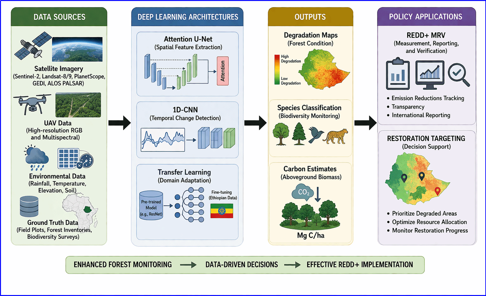
Deep learning outputs can significantly strengthen Ethiopia’s REDD+ Measurement, Reporting, and Verification (MRV) system by enabling high-resolution, activity-data-driven monitoring of deforestation and land-use change. High-accuracy post-deforestation land-use maps (85–89 percent) generated using Attention U-Net provide detailed information on conversion patterns in agroforestry zones, supporting more precise emissions accounting, identification of deforestation drivers, and targeted restoration planning.9 By integrating these outputs into national monitoring workflows, Ethiopia can transition from coarse, reactive assessments to spatially explicit and timely evaluations of land-use dynamics. The proposed conceptual framework ( Figure 2) illustrates how multi-sensor deep learning outputs can be operationalized through hybrid monitoring systems that combine Sentinel-2 for wall-to-wall coverage, Planet NICFI for hotspot detection, and PRISMA for detailed vegetation characterization.
Improved degradation detection represents a particularly important opportunity for enhancing Ethiopia’s REDD+ implementation. Once strengthened through the integration of PRISMA hyperspectral data and multi-sensor deep learning approaches, degradation monitoring can enable the reporting of avoided forest degradation—an element that remains underrepresented in national MRV systems.7,12 Species-level mapping and canopy-structural indicators derived from hyperspectral and multi-sensor models further support more accurate carbon stock estimation and biodiversity monitoring in coffee and woodlot agroforestry landscapes.6,13 Beyond REDD+, deep learning-based risk assessment outputs can inform integrated land-use planning by linking forest conservation objectives with hazard mitigation and landscape resilience at district scales.19 Collectively, these applications can shift Ethiopia’s REDD+ strategy from reactive forest loss detection to proactive landscape management, supporting the national goal of restoring 20 million hectares while strengthening carbon finance opportunities and sustainable agroforestry livelihoods.
Attention U-Net represents the current state-of-the-art for Ethiopia-specific post-deforestation land-use classification, achieving 85–89 percent overall accuracy when applied to fused Planet NICFI very-high-resolution imagery with Sentinel-2 and Landsat time series.9,20 The attention mechanism has proven particularly effective in capturing the fine-scale spatial heterogeneity characteristic of smallholder-dominated landscapes, where individual plots are often smaller than 0.5 hectares. Complementing these spatial approaches, hyperspectral data provide unprecedented species-level insights that remain unattainable with conventional multispectral sensors. With 234 contiguous spectral bands spanning 400–2500 nm, hyperspectral imagery enables detailed discrimination of key biochemical traits such as chlorophyll content, leaf water status, lignin, and cellulose, thereby enhancing vegetation characterization in complex agroforestry systems.7,6
Despite these advances, a persistent performance gap remains evident between deforestation and degradation detection. While deforestation detection consistently reaches 90–95 percent accuracy across studies, degradation detection lags at 71–85 percent, posing significant challenges for Ethiopia’s REDD+ Measurement, Reporting, and Verification (MRV) system, which requires reliable quantification of both processes to access results-based payments. Encouragingly, the application of one-dimensional convolutional neural networks (1D-CNNs) to PRISMA hyperspectral signatures has demonstrated strong promise, achieving 94 percent accuracy for deforestation and 92 percent for degradation detection in tropical contexts, with clear potential for transferability to Ethiopian agroforestry systems.12 Moreover, studies such as19 highlight the broader applicability of deep learning approaches by extending their use beyond forest monitoring to integrated land-use/land-cover change (LULCC) analysis and debris-flow hazard risk assessment in districts like Adama, underscoring the versatility of these methods for addressing multifaceted environmental challenges in Ethiopia.19
Compared with the broader global literature on deep learning for forest monitoring, the Ethiopian body of work exhibits several distinctive characteristics shaped by local socio-ecological realities. While studies in data-rich regions such as North America and Europe routinely train models from scratch on large, high-quality labelled datasets, Ethiopian research places far greater emphasis on transfer learning to overcome severe data scarcity.3 This necessity arises because labelled training samples for smallholder agroforestry systems remain extremely limited, in contrast to the abundant reference data available in temperate forest zones. Moreover, the average smallholder farm size in Ethiopia (approximately 0.3 hectares) demands very-high-resolution imagery (Planet NICFI at 3–5 m or WorldView at 2 m) to resolve individual tree crowns and subtle degradation signals, whereas many global studies continue to rely on moderate-resolution Landsat or Sentinel-2 data (10–30 m) that are insufficient for Ethiopian-scale dynamics. Coffee agroforestry systems introduce additional complexity through persistent spectral mixing, as the understory coffee shrubs remain green and photosynthetically active even after shade-tree removal, creating a false impression of forest health that challenges vegetation-index-based approaches.10
These context-specific constraints are clearly illustrated by Figure 3, which reveals a pronounced geographic imbalance in the reviewed studies, with 60% concentrated in Oromia, 25% in Amhara, and only 15% in SNNPR, leaving vast areas such as Somali, Afar, and Gambella entirely unrepresented.2,9,14 This spatial skew limits the generalisability of current models to the full ecological diversity of Ethiopian agroforestry landscapes.10 Figure 2, the conceptual framework, directly addresses these gaps by outlining a hybrid, multi-sensor workflow that integrates transfer learning, very-high-resolution data, and PRISMA hyperspectral inputs to produce actionable outputs for REDD+ MRV.6,7,9 Together, the two figures underscore that while global deep-learning methods provide valuable methodological foundations,5 their successful adaptation to Ethiopia requires explicit consideration of smallholder-scale heterogeneity, regional data gaps, and coffee-specific spectral challenges if deep learning is to deliver equitable and nationally relevant forest monitoring.
.
Adopt hybrid sensors (Sentinel-2 annual, Planet NICFI quarterly, PRISMA species-level, UAV validation). Prioritize transfer learning and create an open Ethiopian Agroforestry Tree Crown Dataset. Invest in Google Earth Engine workflows.
As presented in figure 2, a structured conceptual model that synthesizes the key components of the reviewed literature into a practical workflow for operational forest monitoring. It visually links multi-source remote sensing data inputs to advanced deep learning architectures, model outputs, and ultimate policy applications under Ethiopia’s REDD+ framework.
The framework typically flows from left to right in four interconnected stages:
1. As for the Data Sources a very high-resolution optical imagery (e.g., Planet NICFI at 3–5 m), multispectral time series (Sentinel-2 at 10 m), hyperspectral data (PRISMA with 234 bands), and auxiliary inputs such as GEDI LiDAR, Sentinel-1 SAR, and topographic data (SRTM). These inputs address the limitations of traditional coarse-resolution sensors (Landsat/MODIS) in detecting fine-scale dynamics in smallholder-dominated agroforestry systems.
2. Referring to the Deep Learning Architectures, core models include Attention U-Net for post-deforestation land-use classification, 1D-CNN for pixel-wise hyperspectral analysis, multi-layer perceptron networks for degradation detection in coffee systems, and transfer learning approaches to overcome limited labeled data. Hybrid or ensemble models (e.g., CNN + RNN for temporal trajectories) further enhance performance.
3. As for the Outputs, high-accuracy products such as degradation maps (80–92% accuracy in various studies), species-level classification (>90% with PRISMA), canopy height/cover estimates, and post-deforestation land-use trajectories (85–89% with Attention U-Net). These outputs directly tackle challenges like spectral mixing in coffee understories and class imbalance in degradation pixels.
4. As a Policy Application, its integration into Ethiopia’s national REDD+ Measurement, Reporting, and Verification (MRV) system would support results-based payments, enable early intervention against forest degradation, guide Forest Landscape Restoration efforts (targeting 20 million hectares by 2030), and strengthen evidence-based land-use planning.
The conceptual framework emphasizes the transformative role of multi-sensor fusion and transfer learning while highlighting remaining gaps—such as the need for localized training datasets and cloud computing infrastructure. It serves as a roadmap for researchers and policymakers, illustrating how deep learning can bridge the accuracy gap between deforestation (90–95%) and degradation detection (71–85%), ultimately enabling proactive conservation in complex Ethiopian agroforestry landscapes.
Together, these figures strengthen the manuscript by providing visual clarity: Figure 1 ensures methodological rigor and transparency, while Figure 2 translates the synthesized evidence into an actionable model for real-world application. They complement the tables (e.g., Table 1 summarizing studies and Table 2 comparing task performance) by offering an at-a-glance overview that enhances reader comprehension and supports the review’s policy recommendations.
| Task | Accuracy range | Primary limitation | Key references |
|---|---|---|---|
| Deforestation detection | 90–95% | Abrupt change | 9,12 |
| Degradation detection | 71–85% | Subtle signals, imbalance | 10,12 |
| Species/woodlot mapping | 88.7–96.3% | Regional specificity | 1,7 |
| Post-deforestation LULC | 85–89% | Small plot size | 9 |
Several limitations must be acknowledged. First, only fifteen Ethiopia-specific deep learning studies exist, limiting generalizability, especially for underrepresented zones like Somali, Afar, or Gambella. Second, publication bias toward positive results likely inflates perceived performance of models like Attention U-Net. Third, grey literature was excluded due to inconsistent availability, omitting localized insights. Fourth, heterogeneity in metrics and designs prevented meta-analysis; degradation accuracies ranged from 71–85% across systems. Fifth, computational costs and model interpretability were not assessed—key gaps for resource-constrained settings. Finally, the English-only scope may have missed relevant non-English studies. Collectively, these limitations suggest cautious interpretation. Still, the review offers a foundation for future research, highlighting needs for open datasets, standardized protocols, and inclusion of grey literature to support Ethiopia’s REDD+ and restoration targets.
The synthesis of the 20 included studies reveals substantial progress in deep learning applications for forest monitoring in Ethiopian agroforestry landscapes, yet significant gaps remain in methodological robustness, geographic coverage, data integration, and operational scalability. These gaps, combined with emerging global trends in remote sensing and artificial intelligence, point to a rich agenda for research from 2025 to 2030 and beyond. The following expanded directions build directly on the identified limitations—such as the accuracy gap between deforestation (90–95%) and degradation detection (71–85%), limited labeled datasets, spectral mixing in coffee systems, and uneven regional focus—while incorporating opportunities from hyperspectral sensors, multi-modal fusion, and policy needs under Ethiopia’s REDD+ and Forest Landscape Restoration commitments (targeting 20 million hectares restored by 2030).
First, priority should be given to developing and validating degradation-specific deep learning algorithms tailored to Ethiopian agroforestry systems. Current models perform well for detecting abrupt canopy removal but struggle with subtle, gradual changes such as selective logging, shade-tree thinning, and understory shifts in coffee landscapes, largely due to spectral mixing and class imbalance.9,10 Future work must replicate and adapt high-performing approaches such as one-dimensional convolutional neural networks (1D-CNNs) applied to PRISMA hyperspectral data—which achieved approximately 92% accuracy for degradation detection in the Amazon forest—to Ethiopian agroforestry contexts.12 This includes explicit comparisons of PRISMA-only, Sentinel-2-only, and fused PRISMA + Sentinel-1 SAR models to mitigate persistent cloud cover during the June–September rainy season and improve robustness across seasons.6,7
Researchers should further enhance model sensitivity to early degradation signals by incorporating biophysical priors derivable from PRISMA’s 234 contiguous spectral bands—such as leaf water content, chlorophyll, lignin, and cellulose indices—and by testing advanced temporal and hybrid architectures, including transformers and CNN–LSTM models, which have demonstrated strong potential for capturing gradual forest dynamics in time-series remote sensing dat.5,11 Longitudinal field validation using repeated plot measurements will be essential to reduce false positives, improve generalizability across agroforestry systems, and ensure compliance with REDD+ Measurement, Reporting, and Verification requirements.9,13
Second, the creation and public release of large-scale, open benchmark datasets specific to Ethiopian agroforestry must become a national and international priority. The current scarcity of labeled training data—particularly for smallholder plots (<0.5 ha), diverse ecological zones (humid coffee forests, dry Afromontane, Acacia woodlands, Eucalyptus woodlots, parkland systems, Enset homegardens, and highland bamboo), and degradation stages—severely constrains model generalization and transfer learning success. Building on the20 Zenodo dataset, an Ethiopian Agroforestry Tree Crown Dataset (EATCD) should aim for at least 100,000 geolocated samples, including tree species identity, diameter at breast height, canopy cover percentage, degradation status, disturbance history, and socio-economic metadata (e.g., population density correlations as highlighted in.4 Datasets should span multiple seasons and years to capture phenological variability and be released under open licenses (e.g., CC-BY 4.0) with accompanying code repositories. Community-driven annotation involving local farmers and extension agents could incorporate indigenous ecological knowledge as weak labels, improving model robustness while fostering participatory science.
Third, systematic multi-modal and multi-sensor fusion studies are urgently needed. While single-sensor approaches dominate the reviewed literature, combining PRISMA hyperspectral data with Sentinel-1 SAR (cloud-penetrating), Sentinel-2 multispectral time series, GEDI LiDAR-derived canopy height, Planet NICFI very high-resolution imagery, and UAV-derived sub-meter data offers complementary strengths. Future research should evaluate fusion at pixel, feature, decision, and deep learning levels (e.g., using attention-based fusion modules or graph neural networks) to enhance accuracy in complex mosaics where spectral mixing occurs. For instance, SAR can provide structural information during cloudy periods, while hyperspectral bands resolve biochemical traits impossible with multispectral sensors.7,6 Studies should quantify improvements in degradation detection, biomass estimation, and carbon stock modeling, with explicit benchmarking against baselines like the multi-sensor Random Forest models in.13 Edge computing and lightweight model compression techniques will be critical for deployment in resource-constrained Ethiopian institutions.
Fourth, temporal deep learning models require greater emphasis for early warning and predictive forest monitoring. Static or short time-series approaches limit the ability to detect gradual degradation that often precedes full deforestation by 5–10 years in Ethiopian systems, particularly in smallholder agroforestry landscapes.10,11 Advanced temporal architectures such as Long Short-Term Memory (LSTM) networks, ConvLSTM, transformers, and temporal convolutional networks are well suited for capturing long-term forest dynamics and should be applied to dense Sentinel-2 and Landsat time series, potentially augmented with climate variables (e.g., rainfall and land surface temperature) and socio-economic drivers such as population growth and agricultural expansion.4,5,9 Predictive modeling of near-future deforestation risk—building on global initiatives such as ForestCast—could integrate historical loss patterns with dynamic environmental and socio-economic drivers to generate proactive deforestation-risk maps at national or woreda scales, as demonstrated by integrated deep learning–based land-use risk assessments in Ethiopian contexts (Bojer et al., 2023). Such predictive models would directly support targeted interventions under Ethiopia’s Green Legacy Initiative and REDD+ strategy.
Fifth, participatory and socio-ecological integration must be advanced through hybrid human-AI frameworks. Local ecological knowledge from smallholder farmers—regarding species-specific harvesting patterns, charcoal production indicators, or early signs of canopy stress—can serve as valuable weak supervision or validation data. Future studies should co-design community-based monitoring programs that combine smartphone apps for crowdsourced labeling, drone imagery for local validation, and deep learning models for scaling insights. This approach not only improves model accuracy in heterogeneous landscapes but also builds local capacity, addresses equity concerns, and aligns monitoring with livelihood needs. Research should evaluate the cost-effectiveness and scalability of such systems, particularly in data-scarce regions like Afar, Somali, and Gambella, which currently lack coverage ( Figure 2).
Sixth, research must address operational, computational, and ethical barriers to translation into policy and practice. Priorities include: (i) cloud-native workflows on platforms such as Google Earth Engine to reduce hardware dependencies and facilitate large-scale analysis by Ethiopian researchers (Chere et al., 2023; Yebeyen et al., 2024); (ii) improved model interpretability and uncertainty quantification to build trust in operational MRV systems, which is increasingly recognized as a prerequisite for policy uptake of deep learning outputs;5 (iii) the development of lightweight, deployable models suitable for low-bandwidth or offline use in rural areas, where access to high-performance computing remains limited;10 (iv) assessment of computational carbon footprints and the adoption of energy-efficient training strategies, which are particularly relevant in resource-constrained research environments5; and (v) careful consideration of ethical issues surrounding data sovereignty, bias in training datasets—such as the over-representation of Oromia and Amhara—and equitable benefit-sharing from carbon credits under REDD+ mechanisms.4,9 Cross-disciplinary studies linking deep learning outputs to economic valuation of ecosystem services, policy scenario modeling, and climate-adaptation planning will be especially valuable for translating technical advances into actionable decision-support tools (Bojer et al., 2023).
Seventh, expanding geographic and thematic scope is essential for national representativeness. Current studies heavily favor Oromia and Amhara; future work should prioritize under-researched regions and non-tree resources (e.g., bamboo forests).14 Thematic expansion could include integration with drought monitoring (using hyperspectral evapotranspiration indicators), biodiversity habitat mapping, soil erosion risk under restoration scenarios (linking to18), and climate-smart agroforestry optimization. Long-term, pan-African or global transferability studies—leveraging pre-trained foundation models fine-tuned on Ethiopian data—could accelerate progress across similar smallholder contexts.
Finally, sustained investment in capacity building, open science, and multi-stakeholder partnerships is required. Collaborative platforms involving Ethiopian universities, the Ethiopian Space Science and Technology Institute, government agencies (e.g., Ministry of Environment, Forest and Climate Change), CGIAR centers, and international partners should focus on training programs in deep learning and remote sensing, shared computing infrastructure, and standardized protocols for data collection and model benchmarking. Longitudinal monitoring networks with permanent field plots would provide ground truth for continuous model improvement.
Addressing these directions will transform deep learning from a promising research tool into an operational cornerstone of Ethiopia’s forest governance. Early detection of degradation—enabled by hyperspectral and temporal models—can shift interventions from reactive restoration to proactive conservation, helping the country meet its ambitious restoration and climate targets while supporting resilient livelihoods in smallholder agroforestry systems. Coordinated implementation across research, government, and local communities is now the critical next step.
This review synthesizes 15 studies on deep learning for monitoring forest dynamics in Ethiopia’s agroforestry systems. Findings show a maturing field that overcomes limits of traditional remote sensing in smallholder-dominated areas. Attention U-Net on Planet NICFI fused with Sentinel-2 and Landsat achieves 85–89% accuracy across 11 classes, handling plots under 0.5 ha.9 Pan-tropical recurrent/convolutional models enhance land-use trajectory detection.11
PRISMA hyperspectral data with 1D CNNs deliver 94% deforestation and 92% degradation accuracy, transferable to Ethiopia.12 In mixed forests, PRISMA CNNs exceed 90% for tree species via biochemical traits,7,6 enabling species-level monitoring of shade trees and Eucalyptus for REDD+ carbon estimates.
Neural networks on Sentinel-2 in Ethiopian coffee landscapes detect early degradation (canopy thinning, shade-tree loss) at 80–85% accuracy.10 Transfer learning (Senegal to Amhara) exceeds 90% accuracy (>95% for trees/shrubs) with less labeled data.3 Random Forest remains strong for Eucalyptus mapping (96.3%) and canopy estimation,1,13 supporting hybrid workflows.
A performance gap persists: deforestation detection reaches 90–95%, but degradation detection is 71–85%, weakest in coffee understories due to subtle spectral changes, class imbalance, and validation difficulty. This affects Ethiopia’s REDD+ MRV system.
Four requirements emerge: 1) An open Ethiopian Agroforestry Tree Crown Dataset (≥50,000 labeled samples across major zones). 2) Hybrid multi-sensor strategy (Sentinel-2, Planet NICFI, PRISMA, UAV validation). 3) Cloud-native computing (Google Earth Engine, Microsoft Planetary Computer). 4) Degradation-specific algorithms, multi-modal fusion, temporal deep learning (LSTM, Transformers), and participatory ecological knowledge.
Without these, Ethiopia risks missing its 2030 restoration target of 20 million hectares. Degradation precedes deforestation by 5–10 years; early detection using PRISMA and deep learning enables interventions. Foundations exist; political will and coordinated implementation are needed. Bridging the degradation accuracy gap can transition Ethiopia from reactive to proactive forest management, securing climate finance and safeguarding agroforestry landscapes.
| Views | Downloads | |
|---|---|---|
| F1000Research | - | - |
|
PubMed Central
Data from PMC are received and updated monthly.
|
- | - |
Provide sufficient details of any financial or non-financial competing interests to enable users to assess whether your comments might lead a reasonable person to question your impartiality. Consider the following examples, but note that this is not an exhaustive list:
Sign up for content alerts and receive a weekly or monthly email with all newly published articles
Already registered? Sign in
The email address should be the one you originally registered with F1000.
You registered with F1000 via Google, so we cannot reset your password.
To sign in, please click here.
If you still need help with your Google account password, please click here.
You registered with F1000 via Facebook, so we cannot reset your password.
To sign in, please click here.
If you still need help with your Facebook account password, please click here.
If your email address is registered with us, we will email you instructions to reset your password.
If you think you should have received this email but it has not arrived, please check your spam filters and/or contact for further assistance.
Comments on this article Comments (0)