Revised
Amendments from Version 2
This version of the manuscript mainly addresses confusion about the figures. We have added clarification about how the figures were created and what data were used to construct them. We also included a new version of the waterfowl survey data. Previously omitted in the earlier version, bufflehead is now included. This dataset was the final dataset we used to conduct our analysis. We also took advantage of this revision to address minor semantic and grammatical issues.
This version of the manuscript mainly addresses confusion about the figures. We have added clarification about how the figures were created and what data were used to construct them. We also included a new version of the waterfowl survey data. Previously omitted in the earlier version, bufflehead is now included. This dataset was the final dataset we used to conduct our analysis. We also took advantage of this revision to address minor semantic and grammatical issues.
See the authors' detailed response to the review by José Manuel Arcos
See the authors' detailed response to the review by L. Ignacio Vilchis
Introduction
As modern environmental pressures continue to adversely impact natural habitats, global waterfowl populations are declining at accelerated rates. According to the Millennium Ecosystem Assessment, approximately 12% of all bird species are presently threatened with extinction, and 41% of all waterfowl populations are declining in abundance (Assessment, 2003; Assessment, 2005). Narragansett Bay’s waterfowl communities are not immune to the global drivers of waterfowl population decline and modifications of waterfowl communities; Narragansett Bay is exposed to habitat conversion, shoreline hardening, increased sedimentation and pollution, and increased threats from climate change (Nixon & Fulweiler, 2012). Even though we know that these changing conditions are having a global impact on waterfowl populations, we are uncertain about the specific ramifications on Narragansett Bay’s wintering waterfowl communities. Twenty-three North American waterfowl species have been observed wintering in Narragansett Bay, including 11 of the 15 known species of sea ducks, a guild of waterfowl that breed in boreal Canada and winter as far south as Chesapeake Bay (McKinney, 2004). Understanding or predicting deviations from normal is not possible without baseline monitoring data on waterfowl communities (Temple & Wiens, 1989).
In 2004, the Atlantic Ecology Division (AED) of the US Environmental Protection Agency’s (EPA’s) Office of Research and Development, in collaboration with state wildlife agencies and local environmental groups, began an annual winter waterfowl survey of Rhode Island’s Narragansett Bay (hence forth referred to as the Bay). Every year in January, local wildlife biologists and environmental scientists conduct a comprehensive survey of the Bay’s waterfowl. The waterfowl survey was implemented in an attempt to fill critical gaps in our ecological knowledge about the Bay’s waterfowl communities. While there have been numerous waterfowl studies conducted in the Narragansett Bay watershed (Caron & Paton, 2007; Loring et al., 2013; McKinney & McWilliams, 2005), we are unaware of any long-term multispecies studies. Consequently, we are still relatively ill-informed about long-term trends of the Bay’s waterfowl populations and communities. The survey data can also provide us a means to monitor the Bay’s overall environmental health by using waterfowl as a bioindicator. Due to waterfowl’s comparatively high trophic status, waterfowl communities provide insight about local food webs’ relative health and stability.
To determine the underlying waterfowl community structure, we used a multivariate ordination technique, Nonmetric multidimensional scaling (NMDS) (Austin, 1976; Clarke, 1993). Additionally, we propose employing the NMDS as a statistical framework for environmental monitoring of the Bay (Gabrey & Afton, 2004; Urban, 2006). Like other ordination methods, the NMDS approach reduces data complexity, which is critical when analyzing data that are complex and highly variable. Yet unlike other ordination methods, NMDS requires few, if any, a priori assumptions about the distribution of the data. This multivariate approach allows us to detect any relative shifts in community composition between sites and years, and also to explore relationships with potential environmental drivers of change (Clarke & Ainsworth, 1993; Karydis, 1992).
Birds, especially waterfowl, are often the logical candidates for monitoring environmental health (Amat & Green, 2010; Kushlan, 1993). Since waterfowl are high trophic level foragers, the environmental stressors of all lower trophic levels accumulate in waterfowl (Matsinos & Wolff, 2003; O’Connell et al., 2000). Waterfowl have, therefore, been used successfully to monitor a wide array of environmental stressors. For example, these species have been used to monitor a range of heavy metals, including cadmium, mercury, and lead (Mochizuki et al., 2002; Ribeiro et al., 2005), and the impacts of habitat conversion, e.g., forested land to agriculture or road (Koper & Schmiegelow, 2006; Maisonneuve et al., 2006). Birds respond to habitat conversion at multiple temporal and spatial scales (DeLuca et al., 2004). Waterfowl respond to these stressors at the local up to the regional scale and their responses can be apparent nearly immediately and continue after substantial time lags (Findlay & Bourdages, 2000). These species have a high detection probability and are easy to identify by even novice birders (Pagano & Arnold, 2009), which further strengthen the argument of using waterfowl as bioindicators of environmental health.
It is nearly impossible to overstate the economic and environmental significance of Narragansett Bay to New England. Narragansett Bay contributes meaningfully to the economy through recreation, tourism, fishing, and shipping (Pastore, 2011; Tyrrell et al., 1994). Its economic contributions are equally matched by its environmental contributions. The Bay serves as critical habitat to numerous species and provides innumerable ecosystem services. This study analyzes the first eight years of our survey data in order to develop a baseline understanding of waterfowl community spatial and temporal structure in the Bay, which can be used to track future changes in the overall health of the Bay.
Methods
Study site
Narragansett Bay is a well-mixed embayment containing a complex of estuaries (Figure 1). The Bay is 234 km2 in area and has a mean depth of 8.7m (Calabretta & Oviatt, 2008; Nixon et al., 2009). In the northern portion of the Bay, the Seekonk and Providence Rivers are the main freshwater sources. The land surrounding the northern portion of Narragansett Bay is also more urban, and exposed to periodic hypoxia, especially in the summer months (Codiga et al., 2009). The southern portion of the Bay is deeper than the portion near Providence, Rhode Island and has more intense oceanic influences. Additionally, the land surrounding the southern portion tends to be less densely developed and populated.
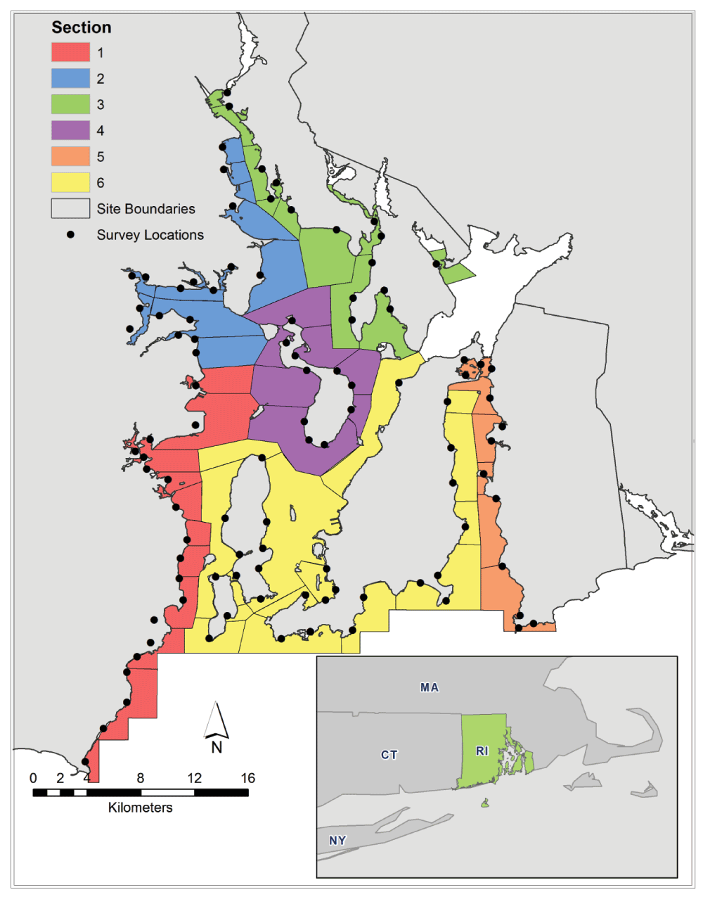
Figure 1. Map of Narragansett Bay, Rhode Island.
Inset of Rhode Island (USA). Sections are color-coded and site boundaries delineated. The points represent the approximate observation locations for the surveys.
Survey method
Initiated in 2004, the NBWWS was completed annually by eight teams composed of 2–4 observers who survey waterfowl at 67 site locations throughout Narragansett Bay (McKinney, 2004). Survey locations were determined by dividing the bay first into sections, and then further into sites within the sections (Figure 1). The number of sites in each section ranged from eight sites in sections 4 and 5 to 15 sites in section 6. The division of sections and sites was based on the geography of the Bay; this layout ensures that all areas of the Bay will be visible from the survey locations (Figure 1). The survey location points were selected to optimize the visual perspectives of the surveyors. Surveyors were given maps of the area and general descriptions of site boundaries. Since the sites were relatively far apart, it is unlikely that individual birds or groups were double counted. Most surveyors also conducted the surveys of adjacent sites.
Coordinated sampling occurs at all sites during a single day in early to mid-January, beginning at approximately 0730 in the morning and ending by 1645 in the afternoon. This is a shore-based survey and observers use direct counts to record all waterfowl present at a location at the time of the observation. We define waterfowl species as ducks, geese, swans, and grebes. All birds were identified to the species level, except Lesser and Greater Scaups, that were simple categorized into a single Scaup (Aythya spp.) taxonomic group due to the difficulty of distinguishing them.
Counting is completed from a stationary point from which the entire area (i.e., cove or embayment) is scanned with binoculars or a spotting scope. Every bird seen on the water surface or on the adjoining shoreline up to 50 m from the water edge is counted; when possible sex and age were also noted. Large flocks of > 100 birds are estimated by counting in groups of ten or one hundred. Observers take as much time as necessary to accurately count and record all waterfowl observed. Most locations require between 10–20 minutes to survey.
Data analysis
We initially explored basic population trends for each waterfowl species. This included average abundance and standard deviations between years. We calculated ranked abundance for non-rare species and fitted regression trends and tested significance for each species. Ranked abundance allowed us to examine the relative dominance or rarity of a species given the current community. Furthermore, we assessed total waterfowl abundance and Shannon diversity index by year.
We used nonmetric multidimensional scaling to identify the community level structure of wintering waterfowl in Narragansett Bay (Austin et al., 2001; Clarke & Ainsworth, 1993; Kruskal, 1964). Nonmetric multidimensional scaling is a nonparametric ordination technique used to reduce the dimensionality of a complex data set while maintaining the relative relationship between species composition of sites (Dixon, 2009). This specific ordination method does not require a prior constraining of axes or assumptions of normality. NMDS fits all ordination axes simultaneously not by sequentially finding orthogonal linear axes. Therefore, calculating variance explained by axis or linear goodness of fit measures are not applicable to this specific ordination method.
Nonmetric multidimensional scaling was conducted using survey data collected from 2004 to 2011. A Wisconsin double transform, standardized by species percent abundance and by maximum for each species, was conducted on the species data. This transformation allows for effective detection of species gradient and improves ordination quality. Bray-Curtis distance was used to calculate community distance (for in-depth discussion of methods see Faith et al., 1987; Minchin, 1987). We iteratively fit NMDS solutions of increasing dimensionality to determine the solution with adequate levels of decreased stress. Stress is a measure of goodness of fit; it is a measure of the agreement between the distance in ordination space and observed waterfowl community distance (Kruskal, 1964). Our goal was to minimize stress while avoiding superfluous ordination axes. To find the global stress minimization of an NMDS, random configurations of start locations were interjected into the fitting algorithm (Kruskal & Wish, 1978). All analyses were conducted in R version 2.13.1 (R Development Core Team, 2013) and NMDS was conducted with the Vegan package (Oksanen et al., 2007).
To explore relationships between environmental conditions and the waterfowl community structure, we tested for correlations between the NMDS axes and ancillary variables (Table 1). Ancillary variable selection was hypothesis driven. Initially, we examined the area effect and spatial structure of the waterfowl community composition. Also, we explored the impacts of near shore habitat conversion. Furthermore, we hypothesized that winter intensity and extreme wind events might be driving inter-annual variation. All ancillary variables (Table 1) were initially tested for significance to the final four-dimensional NMDS structure and then cross correlation between variables. Among highly correlated variables, only the most significant variables to the NMDS structure were included in the final analysis.
Table 1. Ancillary variables.
| Abbreviation | Description |
|---|
|
Latitude
| Latitude of site centroid |
|
Longitude
| Longitude of site centroid |
|
mean_bath
| Average bathymetry of site |
|
Depth
| Deepest point in the site |
|
low_bath
| Shallowest point in the site |
|
std_bath
| Standard deviation of bathymetry in the site |
|
Area
| Total area of the site |
|
Perimeter
| Total length of the site perimeter |
|
degr_wet_area
| Total area of wetlands classified as degraded within the site |
|
Wetland
| Total wetland area within the site |
|
NAO.1
| North Atlantic Oscillation Index for January of survey year |
|
NAO.12
| North Atlantic Oscillation Index for December prior to survey |
|
NAO.11
| North Atlantic Oscillation Index for November prior to survey |
|
NAO.win
| Average North Atlantic Oscillation Index for January,
December, and November prior to survey |
|
NAO.10
| North Atlantic Oscillation Index for October prior to survey |
|
NAO.9
| North Atlantic Oscillation Index for September prior to survey |
|
NAO.8
| North Atlantic Oscillation Index for August prior to survey |
|
NAO.fall
| Average North Atlantic Oscillation Index for October,
September, and August prior to survey |
|
WS_day
| Wind speed the day of survey |
|
WS_day_b4
| Wind speed the day before survey |
|
WS_3day
| Average wind speed for the three days prior to survey |
|
WS_7day
| Average wind speed for the seven days prior to survey |
|
WS_30day
| Average wind speed for the thirty days prior to survey |
|
WD_day
| Wind direction the day of survey |
|
WD_day_b4
| Wind direction the day before survey |
|
WD_3day
| Average wind direction for the three days prior to survey |
|
WD_7day
| Average wind direction for the seven days prior to survey |
Location was measured as the latitude and longitude of each site’s centroid. Delineated site boundaries were used to calculate area and site perimeter length (Figure 1). Degraded wetland area was calculated using RI Department of Environmental Management (RI DEM) Statewide Planning Program’s impacted wetland digital vector data, which were downloaded from the RI Geographic Information System (RIGIS) (http://www.edc.uri.edu/rigis). Total wetland area was calculated from the US Fish and Wildlife Service (US FWS) National Wetland Inventory (http://www.fws.gov/wetlands). National Oceanic and Atmospheric Administration’s (NOAA) bathymetry data were also downloaded from RIGIS.
The North Atlantic Oscillation (NAO) is a large-scale climate index that measures the atmospheric pressure at sea level between the Icelandic low and Azores high, which captures information about the relative intensity of the winter (Hurrell, 1995). A strongly positive NAO index is related to above normal temperatures in the study region, whereas a negative NAO index is associated with colder, more severe winters (Visbeck et al., 2001). The NAO index data were obtained from the National Center for Atmospheric Research (NCAR) (climatedataguide.ucar.edu). We used the NAO index to investigate whether winter waterfowl habitat selection was impacted by the relative severity of the winter weather. Wind speed variables were calculated from data downloaded from the NOAA National Climatic Data Center (http://www.ncdc.noaa.gov).
Results
| site_id | site | Site_Name | section_ | latitude | longitude | mean_bath | depth_bath | low_bath | std_bath | area | perimeter | degra_wet_area | degrad_wet_cnt | impact_len | NAO-1 | NAO-12 | NAO-11 | NOA-win | NAO-10 | NAO-9 | NAO-8 | NAO-fall | ws_day_of | ws_day_b4 | ws_3day | ws_7day | ws_30day | wd_day_of | wd_day_b4 | wd_3day | wd_7day |
|---|
| 4101 | 101 | Point Judith | 1 | 41.366912 | -71.477826 | -28.1053 | -118 | 3 | 21.375499 | 1.755437 | 7.433202 | 0 | 0 | 0 | -0.29 | 0.64 | 0.86 | 0.403333333 | -0.07 | 0.01 | -1.26 | -0.44 | 59 | 55 | 50 | 37 | 43 | 290 | 260 | 200 | 213 |
| 4102 | 102 | Narragansett South | 1 | 41.406775 | -71.45014 | -37.131301 | -176 | 4 | 34.8064 | 8.319307 | 16.449304 | 0 | 0 | 0 | -0.29 | 0.64 | 0.86 | 0.403333333 | -0.07 | 0.01 | -1.26 | -0.44 | 59 | 55 | 50 | 37 | 43 | 290 | 260 | 200 | 213 |
| 4103 | 103 | Narragansett Central a-d | 1 | 41.447517 | -71.427438 | -37.387001 | -189 | 5 | 30.7026 | 4.600472 | 19.898889 | 144353.5895 | 3 | 420.206568 | -0.29 | 0.64 | 0.86 | 0.403333333 | -0.07 | 0.01 | -1.26 | -0.44 | 59 | 55 | 50 | 37 | 43 | 290 | 260 | 200 | 213 |
| 4104 | 104 | Bonnet Point | 1 | 41.464399 | -71.41905 | -25.2698 | -80 | 3 | 19.3579 | 4.691832 | 11.551678 | 0 | 0 | 0 | -0.29 | 0.64 | 0.86 | 0.403333333 | -0.07 | 0.01 | -1.26 | -0.44 | 59 | 55 | 50 | 37 | 43 | 290 | 260 | 200 | 213 |
| 4105 | 105 | Narragansett North | 1 | 41.502277 | -71.410661 | -22.446599 | -70 | 3 | 13.911 | 3.128896 | 7.277157 | 0 | 0 | 0 | -0.29 | 0.64 | 0.86 | 0.403333333 | -0.07 | 0.01 | -1.26 | -0.44 | 59 | 55 | 50 | 37 | 43 | 290 | 260 | 200 | 213 |
| 4106 | 106 | Casey Point | 1 | 41.52093 | -71.408099 | -17.688699 | -91 | 3 | 12.2474 | 2.420591 | 6.226811 | 0 | 0 | 0 | -0.29 | 0.64 | 0.86 | 0.403333333 | -0.07 | 0.01 | -1.26 | -0.44 | 59 | 55 | 50 | 37 | 43 | 290 | 260 | 200 | 213 |
| 4107 | 107 | Plum Point / Rome Point | 1 | 41.542096 | -71.413658 | -16.913299 | -51 | 4 | 8.37028 | 3.503596 | 8.086768 | 7593.246173 | 3 | 50.636382 | -0.29 | 0.64 | 0.86 | 0.403333333 | -0.07 | 0.01 | -1.26 | -0.44 | 59 | 55 | 50 | 37 | 43 | 290 | 260 | 200 | 213 |
| 4108 | 108 | Bissel Cove | 1 | 41.556029 | -71.420593 | -19.104299 | -60 | 6 | 11.633399 | 2.829623 | 11.9081 | 6248.567297 | 1 | 0 | -0.29 | 0.64 | 0.86 | 0.403333333 | -0.07 | 0.01 | -1.26 | -0.44 | 59 | 55 | 50 | 37 | 43 | 290 | 260 | 200 | 213 |
| 4109 | 109 | Wickford Harbor | 1 | 41.569464 | -71.419435 | -24.724599 | -110 | 4 | 20.7562 | 6.172422 | 19.138682 | 102043.0007 | 4 | 0 | -0.29 | 0.64 | 0.86 | 0.403333333 | -0.07 | 0.01 | -1.26 | -0.44 | 59 | 55 | 50 | 37 | 43 | 290 | 260 | 200 | 213 |
| 4110 | 110 | Quonset Point | 1 | 41.598239 | -71.384624 | -45.728801 | -171 | 4 | 33.397499 | 13.547721 | 20.223494 | 0 | 0 | 0 | -0.29 | 0.64 | 0.86 | 0.403333333 | -0.07 | 0.01 | -1.26 | -0.44 | 59 | 55 | 50 | 37 | 43 | 290 | 260 | 200 | 213 |
| 4111 | 112 | Allen Harbor | 1 | 41.623072 | -71.412812 | -22.798 | -49 | 4 | 9.992449 | 0.261369 | 2.735376 | 0 | 0 | 0 | -0.29 | 0.64 | 0.86 | 0.403333333 | -0.07 | 0.01 | -1.26 | -0.44 | 54 | 57 | 30 | 35 | 41 | 310 | 270 | 193 | 161 |
| 4112 | 111 | Davisville North | 1 | 41.623401 | -71.389762 | -22.465099 | -104 | 4 | 14.557 | 5.592865 | 10.061208 | 0 | 0 | 0 | -0.29 | 0.64 | 0.86 | 0.403333333 | -0.07 | 0.01 | -1.26 | -0.44 | 54 | 57 | 30 | 35 | 41 | 310 | 270 | 193 | 161 |
| 4202 | 202 | Potowomut | 2 | 41.660187 | -71.382386 | -37.131301 | -176 | 4 | 34.8064 | 10.846078 | 20.904299 | 23247.6788 | 1 | 108.084265 | -0.29 | 0.64 | 0.86 | 0.403333333 | -0.07 | 0.01 | -1.26 | -0.44 | 54 | 57 | 30 | 35 | 41 | 310 | 270 | 193 | 161 |
| 4203 | 203 | Greenwich Cove | 2 | 41.656045 | -71.446908 | -37.387001 | -189 | 5 | 30.7026 | 1.724177 | 11.033636 | 0 | 0 | 0 | -0.29 | 0.64 | 0.86 | 0.403333333 | -0.07 | 0.01 | -1.26 | -0.44 | 54 | 57 | 30 | 35 | 41 | 310 | 270 | 193 | 161 |
| 4204 | 204 | Apponaug Cove | 2 | 41.683557 | -71.441777 | -25.2698 | -80 | 3 | 19.3579 | 1.302633 | 8.053971 | 472856.3743 | 2 | 168.79368 | -0.29 | 0.64 | 0.86 | 0.403333333 | -0.07 | 0.01 | -1.26 | -0.44 | 54 | 57 | 30 | 35 | 41 | 310 | 270 | 193 | 161 |
| 4205 | 205 | Greenwich Bay N | 2 | 41.681812 | -71.425441 | -22.446599 | -70 | 3 | 13.911 | 3.379968 | 9.661274 | 0 | 0 | 91.696162 | -0.29 | 0.64 | 0.86 | 0.403333333 | -0.07 | 0.01 | -1.26 | -0.44 | 54 | 57 | 30 | 35 | 41 | 310 | 270 | 193 | 161 |
| 4206 | 206 | Brush Neck Cove | 2 | 41.687066 | -71.405616 | -17.688699 | -91 | 3 | 12.2474 | 0.461473 | 6.795905 | 0 | 0 | 0 | -0.29 | 0.64 | 0.86 | 0.403333333 | -0.07 | 0.01 | -1.26 | -0.44 | 54 | 57 | 30 | 35 | 41 | 310 | 270 | 193 | 161 |
| 4207 | 207 | Warwick Cove | 2 | 41.697986 | -71.384884 | -16.913299 | -51 | 4 | 8.37028 | 0.440682 | 6.649902 | 0 | 0 | 48.919913 | -0.29 | 0.64 | 0.86 | 0.403333333 | -0.07 | 0.01 | -1.26 | -0.44 | 54 | 57 | 30 | 35 | 41 | 310 | 270 | 193 | 161 |
| 4208 | 208 | Lower Providence River West | 2 | 41.696495 | -71.356495 | -19.104299 | -60 | 6 | 11.633399 | 11.400991 | 16.185039 | 5496.750007 | 2 | 38.648861 | -0.29 | 0.64 | 0.86 | 0.403333333 | -0.07 | 0.01 | -1.26 | -0.44 | 54 | 57 | 30 | 35 | 41 | 310 | 270 | 193 | 161 |
| 4209 | 209 | Gaspee Point | 2 | 41.728688 | -71.367498 | -24.724599 | -110 | 4 | 20.7562 | 6.10457 | 13.229468 | 7471.282094 | 1 | 149.104558 | -0.29 | 0.64 | 0.86 | 0.403333333 | -0.07 | 0.01 | -1.26 | -0.44 | 54 | 57 | 30 | 35 | 41 | 310 | 270 | 193 | 161 |
| 4210 | 210 | Passeonkquis Cove | 2 | 41.749085 | -71.376248 | -45.728801 | -171 | 4 | 33.397499 | 1.356353 | 6.396115 | 0 | 0 | 303.742956 | -0.29 | 0.64 | 0.86 | 0.403333333 | -0.07 | 0.01 | -1.26 | -0.44 | 54 | 57 | 30 | 35 | 41 | 310 | 270 | 193 | 161 |
| 4211 | 211 | Pawtuxet Cove | 2 | 41.761742 | -71.380602 | -22.798 | -49 | 4 | 9.992449 | 1.672774 | 6.466399 | 0 | 0 | 410.556533 | -0.29 | 0.64 | 0.86 | 0.403333333 | -0.07 | 0.01 | -1.26 | -0.44 | 54 | 57 | 30 | 35 | 41 | 310 | 270 | 193 | 161 |
| 4212 | 212 | Providence River NW | 2 | 41.777049 | -71.384011 | -22.465099 | -104 | 4 | 14.557 | 1.902445 | 6.043397 | 47264.70308 | 2 | 0 | -0.29 | 0.64 | 0.86 | 0.403333333 | -0.07 | 0.01 | -1.26 | -0.44 | 54 | 57 | 30 | 35 | 41 | 310 | 270 | 193 | 161 |
| 4301 | 301 | Providence Harbor | 3 | 41.810453 | -71.399014 | -28.1053 | -118 | 3 | 21.375499 | 0.982654 | 5.453465 | 17072.257 | 1 | 90.721134 | -0.29 | 0.64 | 0.86 | 0.403333333 | -0.07 | 0.01 | -1.26 | -0.44 | 54 | 57 | 30 | 35 | 41 | 310 | 270 | 193 | 161 |
| 4302 | 302 | Upper Providence River | 3 | 41.799201 | -71.385123 | -37.131301 | -176 | 4 | 34.8064 | 2.397551 | 9.872773 | 40217.50025 | 4 | 73.983279 | -0.29 | 0.64 | 0.86 | 0.403333333 | -0.07 | 0.01 | -1.26 | -0.44 | 54 | 57 | 30 | 35 | 41 | 310 | 270 | 193 | 161 |
| 4303 | 303 | Watchemoket Cove | 3 | 41.798936 | -71.376843 | -37.387001 | -189 | 5 | 30.7026 | 0.301938 | 3.545064 | 3003421.028 | 8 | 1592.127547 | -0.29 | 0.64 | 0.86 | 0.403333333 | -0.07 | 0.01 | -1.26 | -0.44 | 54 | 57 | 30 | 35 | 41 | 310 | 270 | 193 | 161 |
| 4304 | 304 | Sabin Point | 3 | 41.770983 | -71.373448 | -25.2698 | -80 | 3 | 19.3579 | 3.386023 | 10.712565 | 0 | 0 | 291.361618 | -0.29 | 0.64 | 0.86 | 0.403333333 | -0.07 | 0.01 | -1.26 | -0.44 | 54 | 57 | 30 | 35 | 41 | 310 | 270 | 193 | 161 |
| 4305 | 305 | Bullock's Cove | 3 | 41.740886 | -71.36442 | -22.446599 | -70 | 3 | 13.911 | 1.598707 | 10.007319 | 48133.5218 | 1 | 319.282153 | -0.29 | 0.64 | 0.86 | 0.403333333 | -0.07 | 0.01 | -1.26 | -0.44 | 54 | 57 | 30 | 35 | 41 | 310 | 270 | 193 | 161 |
| 4306 | 306 | Bullock's Point | 3 | 41.731868 | -71.347845 | -17.688699 | -91 | 3 | 12.2474 | 2.434379 | 8.478397 | 47908.49552 | 2 | 173.668931 | -0.29 | 0.64 | 0.86 | 0.403333333 | -0.07 | 0.01 | -1.26 | -0.44 | 54 | 57 | 30 | 35 | 41 | 310 | 270 | 193 | 161 |
| 4307 | 307 | Barrington Beach | 3 | 41.705899 | -71.321874 | -16.913299 | -51 | 4 | 8.37028 | 11.480633 | 13.603381 | 1251.820066 | 1 | 0 | -0.29 | 0.64 | 0.86 | 0.403333333 | -0.07 | 0.01 | -1.26 | -0.44 | 54 | 57 | 30 | 35 | 41 | 310 | 270 | 193 | 161 |
| 4308 | 308 | Upper Barrington River | 3 | 41.742875 | -71.306042 | -19.104299 | -60 | 6 | 11.633399 | 0.930669 | 8.231336 | 87158.76139 | 1 | 1586.463241 | -0.29 | 0.64 | 0.86 | 0.403333333 | -0.07 | 0.01 | -1.26 | -0.44 | 54 | 57 | 30 | 35 | 41 | 310 | 270 | 193 | 161 |
| 4309 | 309 | Warren River | 3 | 41.719141 | -71.289255 | -24.724599 | -110 | 4 | 20.7562 | 1.821363 | 11.82633 | 302459.4076 | 11 | 366.727881 | -0.29 | 0.64 | 0.86 | 0.403333333 | -0.07 | 0.01 | -1.26 | -0.44 | 54 | 57 | 30 | 35 | 41 | 310 | 270 | 193 | 161 |
| 4310 | 310 | Kikemuit River | 3 | 41.69421 | -71.237519 | -45.728801 | -171 | 4 | 33.397499 | 2.70313 | 11.131266 | 0 | 0 | 1.105049 | -0.29 | 0.64 | 0.86 | 0.403333333 | -0.07 | 0.01 | -1.26 | -0.44 | 54 | 57 | 30 | 35 | 41 | 310 | 270 | 193 | 161 |
| 4311 | 311 | Colt State Park | 3 | 41.666108 | -71.312328 | -22.798 | -49 | 4 | 9.992449 | 8.576449 | 20.746951 | 2218887.973 | 8 | 1001.580563 | -0.29 | 0.64 | 0.86 | 0.403333333 | -0.07 | 0.01 | -1.26 | -0.44 | 54 | 57 | 30 | 35 | 41 | 310 | 270 | 193 | 161 |
| 4312 | 312 | Bristol Harbor | 3 | 41.654536 | -71.289773 | -22.465099 | -104 | 4 | 14.557 | 7.127758 | 17.073373 | 701429.2856 | 3 | 801.256343 | -0.29 | 0.64 | 0.86 | 0.403333333 | -0.07 | 0.01 | -1.26 | -0.44 | 59 | 55 | 50 | 37 | 43 | 290 | 260 | 200 | 213 |
| 4401 | 401 | T-Dock | 4 | 41.593974 | -71.35572 | -28.1053 | -118 | 3 | 21.375499 | 16.678744 | 22.690639 | 0 | 0 | 0 | -0.29 | 0.64 | 0.86 | 0.403333333 | -0.07 | 0.01 | -1.26 | -0.44 | 59 | 55 | 50 | 36 | 43 | 290 | 260 | 200 | 213 |
| 4402 | 402 | Lighthouse | 4 | 41.602254 | -71.299041 | -37.131301 | -176 | 4 | 34.8064 | 2.511426 | 8.144549 | 0 | 0 | 0 | -0.29 | 0.64 | 0.86 | 0.403333333 | -0.07 | 0.01 | -1.26 | -0.44 | 59 | 55 | 50 | 36 | 43 | 290 | 260 | 200 | 213 |
| 4403 | 403 | Ferry Landing | 4 | 41.628538 | -71.301041 | -37.387001 | -189 | 5 | 30.7026 | 5.58494 | 9.802353 | 0 | 0 | 0 | -0.29 | 0.64 | 0.86 | 0.403333333 | -0.07 | 0.01 | -1.26 | -0.44 | 59 | 55 | 50 | 36 | 43 | 290 | 260 | 200 | 213 |
| 4404 | 404 | Nag Pond | 4 | 41.628442 | -71.320327 | -25.2698 | -80 | 3 | 19.3579 | 0.061509 | 1.512612 | 52816.6649 | 1 | 0 | -0.29 | 0.64 | 0.86 | 0.403333333 | -0.07 | 0.01 | -1.26 | -0.44 | 59 | 55 | 50 | 36 | 43 | 290 | 260 | 200 | 213 |
| 4405 | 405 | Prudence West | 4 | 41.619156 | -71.35013 | -22.446599 | -70 | 3 | 13.911 | 10.16901 | 12.302898 | 0 | 0 | 0 | -0.29 | 0.64 | 0.86 | 0.403333333 | -0.07 | 0.01 | -1.26 | -0.44 | 59 | 55 | 50 | 36 | 43 | 290 | 260 | 200 | 213 |
| 4406 | 406 | Potter Cove | 4 | 41.644773 | -71.325205 | -17.688699 | -91 | 3 | 12.2474 | 6.221589 | 14.189029 | 71000.97559 | 2 | 0 | -0.29 | 0.64 | 0.86 | 0.403333333 | -0.07 | 0.01 | -1.26 | -0.44 | 54 | 57 | 30 | 28 | 41 | 310 | 270 | 193 | 161 |
| 4407 | 407 | Coggeshal Cove | 4 | 41.639116 | -71.363541 | -16.913299 | -51 | 4 | 8.37028 | 2.941461 | 11.152658 | 178141.706 | 3 | 0 | -0.29 | 0.64 | 0.86 | 0.403333333 | -0.07 | 0.01 | -1.26 | -0.44 | 54 | 57 | 30 | 28 | 41 | 310 | 270 | 193 | 161 |
| 4501 | 501 | Portsmouth Cove | 5 | 41.631067 | -71.223995 | -28.1053 | -118 | 3 | 21.375499 | 1.337452 | 9.16791 | 0 | 0 | 2503.30761 | -0.29 | 0.64 | 0.86 | 0.403333333 | -0.07 | 0.01 | -1.26 | -0.44 | 59 | 55 | 50 | 35 | 43 | 290 | 260 | 200 | 213 |
| 4502 | 502 | Sakonnet River / Island Park | 5 | 41.619324 | -71.232035 | -37.387001 | -189 | 5 | 30.7026 | 3.330016 | 11.625559 | 0 | 0 | 0 | -0.29 | 0.64 | 0.86 | 0.403333333 | -0.07 | 0.01 | -1.26 | -0.44 | 59 | 55 | 50 | 35 | 43 | 290 | 260 | 200 | 213 |
| 4503 | 503 | Tiverton Harbor | 5 | 41.632129 | -71.215175 | -37.131301 | -176 | 4 | 34.8064 | 0.735491 | 4.279483 | 0 | 0 | 0 | -0.29 | 0.64 | 0.86 | 0.403333333 | -0.07 | 0.01 | -1.26 | -0.44 | 59 | 55 | 50 | 35 | 43 | 290 | 260 | 200 | 213 |
| 4504 | 504 | Nannaquacket | 5 | 41.611479 | -71.201465 | -25.2698 | -80 | 3 | 19.3579 | 0.845243 | 4.96333 | 177855.1097 | 2 | 102.063345 | -0.29 | 0.64 | 0.86 | 0.403333333 | -0.07 | 0.01 | -1.26 | -0.44 | 59 | 55 | 50 | 35 | 43 | 290 | 260 | 200 | 213 |
| 4505 | 505 | Sapowet | 5 | 41.584466 | -71.218244 | -22.446599 | -70 | 3 | 13.911 | 4.134035 | 14.386209 | 89112.79912 | 4 | 159.0426 | -0.29 | 0.64 | 0.86 | 0.403333333 | -0.07 | 0.01 | -1.26 | -0.44 | 59 | 55 | 50 | 35 | 43 | 290 | 260 | 200 | 213 |
| 4506 | 506 | Fogland | 5 | 41.564119 | -71.214699 | -17.688699 | -91 | 3 | 12.2474 | 1.412721 | 8.049312 | 0 | 0 | 0 | -0.29 | 0.64 | 0.86 | 0.403333333 | -0.07 | 0.01 | -1.26 | -0.44 | 59 | 55 | 50 | 32 | 43 | 290 | 260 | 200 | 213 |
| 4507 | 507 | Mary Donovan | 5 | 41.522114 | -71.212315 | -16.913299 | -51 | 4 | 8.37028 | 6.146421 | 13.187372 | 0 | 0 | 0 | -0.29 | 0.64 | 0.86 | 0.403333333 | -0.07 | 0.01 | -1.26 | -0.44 | 59 | 55 | 50 | 32 | 43 | 290 | 260 | 200 | 213 |
| 4508 | 508 | Sakonnet Point | 5 | 41.477207 | -71.20155 | -19.104299 | -60 | 6 | 11.633399 | 8.940693 | 20.150607 | 0 | 0 | 204.13896 | -0.29 | 0.64 | 0.86 | 0.403333333 | -0.07 | 0.01 | -1.26 | -0.44 | 59 | 55 | 50 | 32 | 43 | 290 | 260 | 200 | 213 |
| 4601 | 601 | Newport Harbor | 6 | 41.482548 | -71.322585 | -28.1053 | -118 | 3 | 21.375499 | 4.001439 | 10.212302 | 0 | 0 | 0 | -0.29 | 0.64 | 0.86 | 0.403333333 | -0.07 | 0.01 | -1.26 | -0.44 | 59 | 55 | 50 | 37 | 43 | 290 | 260 | 200 | 213 |
| 4602 | 602 | Fort Adams | 6 | 41.474862 | -71.348731 | -37.131301 | -176 | 4 | 34.8064 | 2.764558 | 11.892194 | 1618.34802 | 1 | 0 | -0.29 | 0.64 | 0.86 | 0.403333333 | -0.07 | 0.01 | -1.26 | -0.44 | 59 | 55 | 50 | 37 | 43 | 290 | 260 | 200 | 213 |
| 4603 | 603 | Brenton Point | 6 | 41.44672 | -71.346243 | -37.387001 | -189 | 5 | 30.7026 | 10.095065 | 19.354248 | 0 | 0 | 0 | -0.29 | 0.64 | 0.86 | 0.403333333 | -0.07 | 0.01 | -1.26 | -0.44 | 59 | 55 | 50 | 37 | 43 | 290 | 260 | 200 | 213 |
| 4604 | 604 | Newport East | 6 | 41.471658 | -71.284418 | -25.2698 | -80 | 3 | 19.3579 | 7.714117 | 15.762173 | 0 | 0 | 0 | -0.29 | 0.64 | 0.86 | 0.403333333 | -0.07 | 0.01 | -1.26 | -0.44 | 59 | 55 | 50 | 37 | 43 | 290 | 260 | 200 | 213 |
| 4605 | 605 | Sachuest Point | 6 | 41.4789 | -71.261206 | -22.446599 | -70 | 3 | 13.911 | 13.803959 | 22.715852 | 6620.819872 | 1 | 0 | -0.29 | 0.64 | 0.86 | 0.403333333 | -0.07 | 0.01 | -1.26 | -0.44 | 59 | 55 | 50 | 37 | 43 | 290 | 260 | 200 | 213 |
| 4606 | 606 | Sandy Point | 6 | 41.527867 | -71.22292 | -17.688699 | -91 | 3 | 12.2474 | 3.476317 | 9.63081 | 0 | 0 | 0 | -0.29 | 0.64 | 0.86 | 0.403333333 | -0.07 | 0.01 | -1.26 | -0.44 | 59 | 55 | 50 | 37 | 43 | 290 | 260 | 200 | 213 |
| 4607 | 607 | McCorrie Point | 6 | 41.57349 | -71.2305 | -16.913299 | -51 | 4 | 8.37028 | 9.176205 | 16.290404 | 0 | 0 | 0 | -0.29 | 0.64 | 0.86 | 0.403333333 | -0.07 | 0.01 | -1.26 | -0.44 | 59 | 55 | 50 | 37 | 43 | 290 | 260 | 200 | 213 |
| 4608 | 608 | Sakonnet River NW | 6 | 41.608914 | -71.2307 | -19.104299 | -60 | 6 | 11.633399 | 2.701842 | 6.661124 | 0 | 0 | 0 | -0.29 | 0.64 | 0.86 | 0.403333333 | -0.07 | 0.01 | -1.26 | -0.44 | 59 | 55 | 50 | 37 | 43 | 290 | 260 | 200 | 213 |
| 4609 | 609 | Arnold Point | 6 | 41.562474 | -71.308328 | -24.724599 | -110 | 4 | 20.7562 | 15.169507 | 28.073795 | 0 | 0 | 67.437782 | -0.29 | 0.64 | 0.86 | 0.403333333 | -0.07 | 0.01 | -1.26 | -0.44 | 59 | 55 | 50 | 37 | 43 | 290 | 260 | 200 | 213 |
| 4610 | 610 | Jamestown East | 6 | 41.526008 | -71.343792 | -45.728801 | -171 | 4 | 33.397499 | 31.202372 | 38.067411 | 17622.64072 | 1 | 0 | -0.29 | 0.64 | 0.86 | 0.403333333 | -0.07 | 0.01 | -1.26 | -0.44 | 59 | 55 | 50 | 37 | 43 | 290 | 260 | 200 | 213 |
| 4611 | 611 | Jamestown North | 6 | 41.572976 | -71.393865 | -22.798 | -49 | 4 | 9.992449 | 6.235953 | 12.254974 | 0 | 0 | 0 | -0.29 | 0.64 | 0.86 | 0.403333333 | -0.07 | 0.01 | -1.26 | -0.44 | 59 | 55 | 50 | 37 | 43 | 290 | 260 | 200 | 213 |
| 4612 | 612 | Jamestown West | 6 | 41.503524 | -71.391306 | -22.465099 | -104 | 4 | 14.557 | 14.175526 | 31.595052 | 343297.3749 | 4 | 397.933258 | -0.29 | 0.64 | 0.86 | 0.403333333 | -0.07 | 0.01 | -1.26 | -0.44 | 59 | 55 | 50 | 37 | 43 | 290 | 260 | 200 | 213 |
| 4613 | 613 | Beavertail | 6 | 41.45244 | -71.406811 | -68.858703 | -123 | -1 | 26.7479 | 6.563586 | 14.395951 | 0 | 0 | 0 | -0.29 | 0.64 | 0.86 | 0.403333333 | -0.07 | 0.01 | -1.26 | -0.44 | 59 | 55 | 50 | 37 | 43 | 290 | 260 | 200 | 213 |
| 4614 | 614 | Hull Cove | 6 | 41.468311 | -71.375436 | -66.145103 | -112 | 0 | 32.901699 | 1.105125 | 5.104586 | 0 | 0 | 0 | -0.29 | 0.64 | 0.86 | 0.403333333 | -0.07 | 0.01 | -1.26 | -0.44 | 59 | 55 | 50 | 37 | 43 | 290 | 260 | 200 | 213 |
| 4615 | 615 | Mackerel / Sheffield Cove | 6 | 41.482989 | -71.382533 | -14.8991 | -52 | 1 | 13.5604 | 1.271297 | 6.789241 | 14469.81844 | 2 | 4.720966 | -0.29 | 0.64 | 0.86 | 0.403333333 | -0.07 | 0.01 | -1.26 | -0.44 | 59 | 55 | 50 | 37 | 43 | 290 | 260 | 200 | 213 |
| 5101 | 101 | Point Judith | 1 | 41.366912 | -71.477826 | -28.1053 | -118 | 3 | 21.375499 | 1.755437 | 7.433202 | 0 | 0 | 0 | 0.73 | 1.21 | 1.52 | 1.153333333 | -0.48 | 0.38 | -1.1 | -0.4 | 59 | 50 | 51 | 55 | 43 | 320 | 310 | 267 | 286 |
| 5102 | 102 | Narragansett South | 1 | 41.406775 | -71.45014 | -37.131301 | -176 | 4 | 34.8064 | 8.319307 | 16.449304 | 0 | 0 | 0 | 0.73 | 1.21 | 1.52 | 1.153333333 | -0.48 | 0.38 | -1.1 | -0.4 | 59 | 50 | 51 | 55 | 43 | 320 | 310 | 267 | 286 |
| 5103 | 103 | Narragansett Central a-d | 1 | 41.447517 | -71.427438 | -37.387001 | -189 | 5 | 30.7026 | 4.600472 | 19.898889 | 144353.5895 | 3 | 420.206568 | 0.73 | 1.21 | 1.52 | 1.153333333 | -0.48 | 0.38 | -1.1 | -0.4 | 59 | 50 | 51 | 55 | 43 | 320 | 310 | 267 | 286 |
| 5104 | 104 | Bonnet Point | 1 | 41.464399 | -71.41905 | -25.2698 | -80 | 3 | 19.3579 | 4.691832 | 11.551678 | 0 | 0 | 0 | 0.73 | 1.21 | 1.52 | 1.153333333 | -0.48 | 0.38 | -1.1 | -0.4 | 59 | 50 | 51 | 55 | 43 | 320 | 310 | 267 | 286 |
| 5105 | 105 | Narragansett North | 1 | 41.502277 | -71.410661 | -22.446599 | -70 | 3 | 13.911 | 3.128896 | 7.277157 | 0 | 0 | 0 | 0.73 | 1.21 | 1.52 | 1.153333333 | -0.48 | 0.38 | -1.1 | -0.4 | 59 | 50 | 51 | 55 | 43 | 320 | 310 | 267 | 286 |
| 5106 | 106 | Casey Point | 1 | 41.52093 | -71.408099 | -17.688699 | -91 | 3 | 12.2474 | 2.420591 | 6.226811 | 0 | 0 | 0 | 0.73 | 1.21 | 1.52 | 1.153333333 | -0.48 | 0.38 | -1.1 | -0.4 | 59 | 50 | 51 | 55 | 43 | 320 | 310 | 267 | 286 |
| 5107 | 107 | Plum Point / Rome Point | 1 | 41.542096 | -71.413658 | -16.913299 | -51 | 4 | 8.37028 | 3.503596 | 8.086768 | 7593.246173 | 3 | 50.636382 | 0.73 | 1.21 | 1.52 | 1.153333333 | -0.48 | 0.38 | -1.1 | -0.4 | 59 | 50 | 51 | 55 | 43 | 320 | 310 | 267 | 286 |
| 5108 | 108 | Bissel Cove | 1 | 41.556029 | -71.420593 | -19.104299 | -60 | 6 | 11.633399 | 2.829623 | 11.9081 | 6248.567297 | 1 | 0 | 0.73 | 1.21 | 1.52 | 1.153333333 | -0.48 | 0.38 | -1.1 | -0.4 | 59 | 50 | 51 | 55 | 43 | 320 | 310 | 267 | 286 |
| 5109 | 109 | Wickford Harbor | 1 | 41.569464 | -71.419435 | -24.724599 | -110 | 4 | 20.7562 | 6.172422 | 19.138682 | 102043.0007 | 4 | 0 | 0.73 | 1.21 | 1.52 | 1.153333333 | -0.48 | 0.38 | -1.1 | -0.4 | 59 | 50 | 51 | 55 | 43 | 320 | 310 | 267 | 286 |
| 5110 | 110 | Quonset Point | 1 | 41.598239 | -71.384624 | -45.728801 | -171 | 4 | 33.397499 | 13.547721 | 20.223494 | 0 | 0 | 0 | 0.73 | 1.21 | 1.52 | 1.153333333 | -0.48 | 0.38 | -1.1 | -0.4 | 59 | 50 | 51 | 55 | 43 | 320 | 310 | 267 | 286 |
| 5111 | 112 | Allen Harbor | 1 | 41.623072 | -71.412812 | -22.798 | -49 | 4 | 9.992449 | 0.261369 | 2.735376 | 0 | 0 | 0 | 0.73 | 1.21 | 1.52 | 1.153333333 | -0.48 | 0.38 | -1.1 | -0.4 | 54 | 42 | 40 | 50 | 40 | 360 | 310 | 303 | 166 |
| 5112 | 111 | Davisville North | 1 | 41.623401 | -71.389762 | -22.465099 | -104 | 4 | 14.557 | 5.592865 | 10.061208 | 0 | 0 | 0 | 0.73 | 1.21 | 1.52 | 1.153333333 | -0.48 | 0.38 | -1.1 | -0.4 | 54 | 42 | 40 | 50 | 40 | 360 | 310 | 303 | 166 |
| 5201 | 201 | Mount View | 2 | 41.642646 | -71.384681 | -28.1053 | -118 | 3 | 21.375499 | 7.979479 | 11.388943 | 0 | 0 | 0 | 0.73 | 1.21 | 1.52 | 1.153333333 | -0.48 | 0.38 | -1.1 | -0.4 | 54 | 42 | 40 | 50 | 40 | 360 | 310 | 303 | 166 |
| 5202 | 202 | Potowomut | 2 | 41.660187 | -71.382386 | -37.131301 | -176 | 4 | 34.8064 | 10.846078 | 20.904299 | 23247.6788 | 1 | 108.084265 | 0.73 | 1.21 | 1.52 | 1.153333333 | -0.48 | 0.38 | -1.1 | -0.4 | 54 | 42 | 40 | 50 | 40 | 360 | 310 | 303 | 166 |
| 5203 | 203 | Greenwich Cove | 2 | 41.656045 | -71.446908 | -37.387001 | -189 | 5 | 30.7026 | 1.724177 | 11.033636 | 0 | 0 | 0 | 0.73 | 1.21 | 1.52 | 1.153333333 | -0.48 | 0.38 | -1.1 | -0.4 | 54 | 42 | 40 | 50 | 40 | 360 | 310 | 303 | 166 |
| 5204 | 204 | Apponaug Cove | 2 | 41.683557 | -71.441777 | -25.2698 | -80 | 3 | 19.3579 | 1.302633 | 8.053971 | 472856.3743 | 2 | 168.79368 | 0.73 | 1.21 | 1.52 | 1.153333333 | -0.48 | 0.38 | -1.1 | -0.4 | 54 | 42 | 40 | 50 | 40 | 360 | 310 | 303 | 166 |
| 5205 | 205 | Greenwich Bay N | 2 | 41.681812 | -71.425441 | -22.446599 | -70 | 3 | 13.911 | 3.379968 | 9.661274 | 0 | 0 | 91.696162 | 0.73 | 1.21 | 1.52 | 1.153333333 | -0.48 | 0.38 | -1.1 | -0.4 | 54 | 42 | 40 | 50 | 40 | 360 | 310 | 303 | 166 |
| 5206 | 206 | Brush Neck Cove | 2 | 41.687066 | -71.405616 | -17.688699 | -91 | 3 | 12.2474 | 0.461473 | 6.795905 | 0 | 0 | 0 | 0.73 | 1.21 | 1.52 | 1.153333333 | -0.48 | 0.38 | -1.1 | -0.4 | 54 | 42 | 40 | 50 | 40 | 360 | 310 | 303 | 166 |
| 5207 | 207 | Warwick Cove | 2 | 41.697986 | -71.384884 | -16.913299 | -51 | 4 | 8.37028 | 0.440682 | 6.649902 | 0 | 0 | 48.919913 | 0.73 | 1.21 | 1.52 | 1.153333333 | -0.48 | 0.38 | -1.1 | -0.4 | 54 | 42 | 40 | 50 | 40 | 360 | 310 | 303 | 166 |
| 5208 | 208 | Lower Providence River West | 2 | 41.696495 | -71.356495 | -19.104299 | -60 | 6 | 11.633399 | 11.400991 | 16.185039 | 5496.750007 | 2 | 38.648861 | 0.73 | 1.21 | 1.52 | 1.153333333 | -0.48 | 0.38 | -1.1 | -0.4 | 54 | 42 | 40 | 50 | 40 | 360 | 310 | 303 | 166 |
| 5209 | 209 | Gaspee Point | 2 | 41.728688 | -71.367498 | -24.724599 | -110 | 4 | 20.7562 | 6.10457 | 13.229468 | 7471.282094 | 1 | 149.104558 | 0.73 | 1.21 | 1.52 | 1.153333333 | -0.48 | 0.38 | -1.1 | -0.4 | 54 | 42 | 40 | 50 | 40 | 360 | 310 | 303 | 166 |
| 5210 | 210 | Passeonkquis Cove | 2 | 41.749085 | -71.376248 | -45.728801 | -171 | 4 | 33.397499 | 1.356353 | 6.396115 | 0 | 0 | 303.742956 | 0.73 | 1.21 | 1.52 | 1.153333333 | -0.48 | 0.38 | -1.1 | -0.4 | 54 | 42 | 40 | 50 | 40 | 360 | 310 | 303 | 166 |
| 5211 | 211 | Pawtuxet Cove | 2 | 41.761742 | -71.380602 | -22.798 | -49 | 4 | 9.992449 | 1.672774 | 6.466399 | 0 | 0 | 410.556533 | 0.73 | 1.21 | 1.52 | 1.153333333 | -0.48 | 0.38 | -1.1 | -0.4 | 54 | 42 | 40 | 50 | 40 | 360 | 310 | 303 | 166 |
| 5212 | 212 | Providence River NW | 2 | 41.777049 | -71.384011 | -22.465099 | -104 | 4 | 14.557 | 1.902445 | 6.043397 | 47264.70308 | 2 | 0 | 0.73 | 1.21 | 1.52 | 1.153333333 | -0.48 | 0.38 | -1.1 | -0.4 | 54 | 42 | 40 | 50 | 40 | 360 | 310 | 303 | 166 |
| 5301 | 301 | Providence Harbor | 3 | 41.810453 | -71.399014 | -28.1053 | -118 | 3 | 21.375499 | 0.982654 | 5.453465 | 17072.257 | 1 | 90.721134 | 0.73 | 1.21 | 1.52 | 1.153333333 | -0.48 | 0.38 | -1.1 | -0.4 | 54 | 42 | 40 | 50 | 40 | 360 | 310 | 303 | 166 |
| 5302 | 302 | Upper Providence River | 3 | 41.799201 | -71.385123 | -37.131301 | -176 | 4 | 34.8064 | 2.397551 | 9.872773 | 40217.50025 | 4 | 73.983279 | 0.73 | 1.21 | 1.52 | 1.153333333 | -0.48 | 0.38 | -1.1 | -0.4 | 54 | 42 | 40 | 50 | 40 | 360 | 310 | 303 | 166 |
| 5303 | 303 | Watchemoket Cove | 3 | 41.798936 | -71.376843 | -37.387001 | -189 | 5 | 30.7026 | 0.301938 | 3.545064 | 3003421.028 | 8 | 1592.127547 | 0.73 | 1.21 | 1.52 | 1.153333333 | -0.48 | 0.38 | -1.1 | -0.4 | 54 | 42 | 40 | 50 | 40 | 360 | 310 | 303 | 166 |
| 5304 | 304 | Sabin Point | 3 | 41.770983 | -71.373448 | -25.2698 | -80 | 3 | 19.3579 | 3.386023 | 10.712565 | 0 | 0 | 291.361618 | 0.73 | 1.21 | 1.52 | 1.153333333 | -0.48 | 0.38 | -1.1 | -0.4 | 54 | 42 | 40 | 50 | 40 | 360 | 310 | 303 | 166 |
| 5305 | 305 | Bullock's Cove | 3 | 41.740886 | -71.36442 | -22.446599 | -70 | 3 | 13.911 | 1.598707 | 10.007319 | 48133.5218 | 1 | 319.282153 | 0.73 | 1.21 | 1.52 | 1.153333333 | -0.48 | 0.38 | -1.1 | -0.4 | 54 | 42 | 40 | 50 | 40 | 360 | 310 | 303 | 166 |
| 5306 | 306 | Bullock's Point | 3 | 41.731868 | -71.347845 | -17.688699 | -91 | 3 | 12.2474 | 2.434379 | 8.478397 | 47908.49552 | 2 | 173.668931 | 0.73 | 1.21 | 1.52 | 1.153333333 | -0.48 | 0.38 | -1.1 | -0.4 | 54 | 42 | 40 | 50 | 40 | 360 | 310 | 303 | 166 |
| 5307 | 307 | Barrington Beach | 3 | 41.705899 | -71.321874 | -16.913299 | -51 | 4 | 8.37028 | 11.480633 | 13.603381 | 1251.820066 | 1 | 0 | 0.73 | 1.21 | 1.52 | 1.153333333 | -0.48 | 0.38 | -1.1 | -0.4 | 54 | 42 | 40 | 50 | 40 | 360 | 310 | 303 | 166 |
| 5308 | 308 | Upper Barrington River | 3 | 41.742875 | -71.306042 | -19.104299 | -60 | 6 | 11.633399 | 0.930669 | 8.231336 | 87158.76139 | 1 | 1586.463241 | 0.73 | 1.21 | 1.52 | 1.153333333 | -0.48 | 0.38 | -1.1 | -0.4 | 54 | 42 | 40 | 50 | 40 | 360 | 310 | 303 | 166 |
| 5309 | 309 | Warren River | 3 | 41.719141 | -71.289255 | -24.724599 | -110 | 4 | 20.7562 | 1.821363 | 11.82633 | 302459.4076 | 11 | 366.727881 | 0.73 | 1.21 | 1.52 | 1.153333333 | -0.48 | 0.38 | -1.1 | -0.4 | 54 | 42 | 40 | 50 | 40 | 360 | 310 | 303 | 166 |
| 5310 | 310 | Kikemuit River | 3 | 41.69421 | -71.237519 | -45.728801 | -171 | 4 | 33.397499 | 2.70313 | 11.131266 | 0 | 0 | 1.105049 | 0.73 | 1.21 | 1.52 | 1.153333333 | -0.48 | 0.38 | -1.1 | -0.4 | 54 | 42 | 40 | 50 | 40 | 360 | 310 | 303 | 166 |
| 5311 | 311 | Colt State Park | 3 | 41.666108 | -71.312328 | -22.798 | -49 | 4 | 9.992449 | 8.576449 | 20.746951 | 2218887.973 | 8 | 1001.580563 | 0.73 | 1.21 | 1.52 | 1.153333333 | -0.48 | 0.38 | -1.1 | -0.4 | 54 | 42 | 40 | 50 | 40 | 360 | 310 | 303 | 166 |
| 5312 | 312 | Bristol Harbor | 3 | 41.654536 | -71.289773 | -22.465099 | -104 | 4 | 14.557 | 7.127758 | 17.073373 | 701429.2856 | 3 | 801.256343 | 0.73 | 1.21 | 1.52 | 1.153333333 | -0.48 | 0.38 | -1.1 | -0.4 | 59 | 50 | 51 | 55 | 43 | 320 | 310 | 267 | 286 |
| 5401 | 401 | T-Dock | 4 | 41.593974 | -71.35572 | -28.1053 | -118 | 3 | 21.375499 | 16.678744 | 22.690639 | 0 | 0 | 0 | 0.73 | 1.21 | 1.52 | 1.153333333 | -0.48 | 0.38 | -1.1 | -0.4 | 59 | 50 | 51 | 37 | 43 | 320 | 310 | 267 | 286 |
| 5402 | 402 | Lighthouse | 4 | 41.602254 | -71.299041 | -37.131301 | -176 | 4 | 34.8064 | 2.511426 | 8.144549 | 0 | 0 | 0 | 0.73 | 1.21 | 1.52 | 1.153333333 | -0.48 | 0.38 | -1.1 | -0.4 | 59 | 50 | 51 | 37 | 43 | 320 | 310 | 267 | 286 |
| 5403 | 403 | Ferry Landing | 4 | 41.628538 | -71.301041 | -37.387001 | -189 | 5 | 30.7026 | 5.58494 | 9.802353 | 0 | 0 | 0 | 0.73 | 1.21 | 1.52 | 1.153333333 | -0.48 | 0.38 | -1.1 | -0.4 | 59 | 50 | 51 | 37 | 43 | 320 | 310 | 267 | 286 |
| 5404 | 404 | Nag Pond | 4 | 41.628442 | -71.320327 | -25.2698 | -80 | 3 | 19.3579 | 0.061509 | 1.512612 | 52816.6649 | 1 | 0 | 0.73 | 1.21 | 1.52 | 1.153333333 | -0.48 | 0.38 | -1.1 | -0.4 | 59 | 50 | 51 | 37 | 43 | 320 | 310 | 267 | 286 |
| 5405 | 405 | Prudence West | 4 | 41.619156 | -71.35013 | -22.446599 | -70 | 3 | 13.911 | 10.16901 | 12.302898 | 0 | 0 | 0 | 0.73 | 1.21 | 1.52 | 1.153333333 | -0.48 | 0.38 | -1.1 | -0.4 | 59 | 50 | 51 | 37 | 43 | 320 | 310 | 267 | 286 |
| 5406 | 406 | Potter Cove | 4 | 41.644773 | -71.325205 | -17.688699 | -91 | 3 | 12.2474 | 6.221589 | 14.189029 | 71000.97559 | 2 | 0 | 0.73 | 1.21 | 1.52 | 1.153333333 | -0.48 | 0.38 | -1.1 | -0.4 | 54 | 42 | 40 | 35 | 40 | 360 | 310 | 303 | 166 |
| 5407 | 407 | Coggeshal Cove | 4 | 41.639116 | -71.363541 | -16.913299 | -51 | 4 | 8.37028 | 2.941461 | 11.152658 | 178141.706 | 3 | 0 | 0.73 | 1.21 | 1.52 | 1.153333333 | -0.48 | 0.38 | -1.1 | -0.4 | 54 | 42 | 40 | 35 | 40 | 360 | 310 | 303 | 166 |
| 5408 | 408 | Providence Point | 4 | 41.671793 | -71.333741 | -19.104299 | -60 | 6 | 11.633399 | 9.498045 | 15.160151 | 1299.688465 | 1 | 0 | 0.73 | 1.21 | 1.52 | 1.153333333 | -0.48 | 0.38 | -1.1 | -0.4 | 54 | 42 | 40 | 35 | 40 | 360 | 310 | 303 | 166 |
| 5501 | 501 | Portsmouth Cove | 5 | 41.631067 | -71.223995 | -28.1053 | -118 | 3 | 21.375499 | 1.337452 | 9.16791 | 0 | 0 | 2503.30761 | 0.73 | 1.21 | 1.52 | 1.153333333 | -0.48 | 0.38 | -1.1 | -0.4 | 59 | 50 | 51 | 37 | 43 | 320 | 310 | 267 | 286 |
| 5502 | 502 | Sakonnet River / Island Park | 5 | 41.619324 | -71.232035 | -37.387001 | -189 | 5 | 30.7026 | 3.330016 | 11.625559 | 0 | 0 | 0 | 0.73 | 1.21 | 1.52 | 1.153333333 | -0.48 | 0.38 | -1.1 | -0.4 | 59 | 50 | 51 | 37 | 43 | 320 | 310 | 267 | 286 |
| 5503 | 503 | Tiverton Harbor | 5 | 41.632129 | -71.215175 | -37.131301 | -176 | 4 | 34.8064 | 0.735491 | 4.279483 | 0 | 0 | 0 | 0.73 | 1.21 | 1.52 | 1.153333333 | -0.48 | 0.38 | -1.1 | -0.4 | 59 | 50 | 51 | 37 | 43 | 320 | 310 | 267 | 286 |
| 5504 | 504 | Nannaquacket | 5 | 41.611479 | -71.201465 | -25.2698 | -80 | 3 | 19.3579 | 0.845243 | 4.96333 | 177855.1097 | 2 | 102.063345 | 0.73 | 1.21 | 1.52 | 1.153333333 | -0.48 | 0.38 | -1.1 | -0.4 | 59 | 50 | 51 | 37 | 43 | 320 | 310 | 267 | 286 |
| 5505 | 505 | Sapowet | 5 | 41.584466 | -71.218244 | -22.446599 | -70 | 3 | 13.911 | 4.134035 | 14.386209 | 89112.79912 | 4 | 159.0426 | 0.73 | 1.21 | 1.52 | 1.153333333 | -0.48 | 0.38 | -1.1 | -0.4 | 59 | 50 | 51 | 37 | 43 | 320 | 310 | 267 | 286 |
| 5506 | 506 | Fogland | 5 | 41.564119 | -71.214699 | -17.688699 | -91 | 3 | 12.2474 | 1.412721 | 8.049312 | 0 | 0 | 0 | 0.73 | 1.21 | 1.52 | 1.153333333 | -0.48 | 0.38 | -1.1 | -0.4 | 59 | 50 | 51 | 37 | 43 | 320 | 310 | 267 | 286 |
| 5507 | 507 | Mary Donovan | 5 | 41.522114 | -71.212315 | -16.913299 | -51 | 4 | 8.37028 | 6.146421 | 13.187372 | 0 | 0 | 0 | 0.73 | 1.21 | 1.52 | 1.153333333 | -0.48 | 0.38 | -1.1 | -0.4 | 59 | 50 | 51 | 37 | 43 | 320 | 310 | 267 | 286 |
| 5508 | 508 | Sakonnet Point | 5 | 41.477207 | -71.20155 | -19.104299 | -60 | 6 | 11.633399 | 8.940693 | 20.150607 | 0 | 0 | 204.13896 | 0.73 | 1.21 | 1.52 | 1.153333333 | -0.48 | 0.38 | -1.1 | -0.4 | 59 | 50 | 51 | 37 | 43 | 320 | 310 | 267 | 286 |
| 5601 | 601 | Newport Harbor | 6 | 41.482548 | -71.322585 | -28.1053 | -118 | 3 | 21.375499 | 4.001439 | 10.212302 | 0 | 0 | 0 | 0.73 | 1.21 | 1.52 | 1.153333333 | -0.48 | 0.38 | -1.1 | -0.4 | 59 | 50 | 51 | 55 | 43 | 320 | 310 | 267 | 286 |
| 5602 | 602 | Fort Adams | 6 | 41.474862 | -71.348731 | -37.131301 | -176 | 4 | 34.8064 | 2.764558 | 11.892194 | 1618.34802 | 1 | 0 | 0.73 | 1.21 | 1.52 | 1.153333333 | -0.48 | 0.38 | -1.1 | -0.4 | 59 | 50 | 51 | 55 | 43 | 320 | 310 | 267 | 286 |
| 5603 | 603 | Brenton Point | 6 | 41.44672 | -71.346243 | -37.387001 | -189 | 5 | 30.7026 | 10.095065 | 19.354248 | 0 | 0 | 0 | 0.73 | 1.21 | 1.52 | 1.153333333 | -0.48 | 0.38 | -1.1 | -0.4 | 59 | 50 | 51 | 55 | 43 | 320 | 310 | 267 | 286 |
| 5604 | 604 | Newport East | 6 | 41.471658 | -71.284418 | -25.2698 | -80 | 3 | 19.3579 | 7.714117 | 15.762173 | 0 | 0 | 0 | 0.73 | 1.21 | 1.52 | 1.153333333 | -0.48 | 0.38 | -1.1 | -0.4 | 59 | 50 | 51 | 55 | 43 | 320 | 310 | 267 | 286 |
| 5605 | 605 | Sachuest Point | 6 | 41.4789 | -71.261206 | -22.446599 | -70 | 3 | 13.911 | 13.803959 | 22.715852 | 6620.819872 | 1 | 0 | 0.73 | 1.21 | 1.52 | 1.153333333 | -0.48 | 0.38 | -1.1 | -0.4 | 59 | 50 | 51 | 55 | 43 | 320 | 310 | 267 | 286 |
| 5606 | 606 | Sandy Point | 6 | 41.527867 | -71.22292 | -17.688699 | -91 | 3 | 12.2474 | 3.476317 | 9.63081 | 0 | 0 | 0 | 0.73 | 1.21 | 1.52 | 1.153333333 | -0.48 | 0.38 | -1.1 | -0.4 | 59 | 50 | 51 | 55 | 43 | 320 | 310 | 267 | 286 |
| 5607 | 607 | McCorrie Point | 6 | 41.57349 | -71.2305 | -16.913299 | -51 | 4 | 8.37028 | 9.176205 | 16.290404 | 0 | 0 | 0 | 0.73 | 1.21 | 1.52 | 1.153333333 | -0.48 | 0.38 | -1.1 | -0.4 | 59 | 50 | 51 | 55 | 43 | 320 | 310 | 267 | 286 |
| 5608 | 608 | Sakonnet River NW | 6 | 41.608914 | -71.2307 | -19.104299 | -60 | 6 | 11.633399 | 2.701842 | 6.661124 | 0 | 0 | 0 | 0.73 | 1.21 | 1.52 | 1.153333333 | -0.48 | 0.38 | -1.1 | -0.4 | 59 | 50 | 51 | 55 | 43 | 320 | 310 | 267 | 286 |
| 5609 | 609 | Arnold Point | 6 | 41.562474 | -71.308328 | -24.724599 | -110 | 4 | 20.7562 | 15.169507 | 28.073795 | 0 | 0 | 67.437782 | 0.73 | 1.21 | 1.52 | 1.153333333 | -0.48 | 0.38 | -1.1 | -0.4 | 59 | 50 | 51 | 55 | 43 | 320 | 310 | 267 | 286 |
| 5610 | 610 | Jamestown East | 6 | 41.526008 | -71.343792 | -45.728801 | -171 | 4 | 33.397499 | 31.202372 | 38.067411 | 17622.64072 | 1 | 0 | 0.73 | 1.21 | 1.52 | 1.153333333 | -0.48 | 0.38 | -1.1 | -0.4 | 59 | 50 | 51 | 55 | 43 | 320 | 310 | 267 | 286 |
| 5611 | 611 | Jamestown North | 6 | 41.572976 | -71.393865 | -22.798 | -49 | 4 | 9.992449 | 6.235953 | 12.254974 | 0 | 0 | 0 | 0.73 | 1.21 | 1.52 | 1.153333333 | -0.48 | 0.38 | -1.1 | -0.4 | 59 | 50 | 51 | 55 | 43 | 320 | 310 | 267 | 286 |
| 5612 | 612 | Jamestown West | 6 | 41.503524 | -71.391306 | -22.465099 | -104 | 4 | 14.557 | 14.175526 | 31.595052 | 343297.3749 | 4 | 397.933258 | 0.73 | 1.21 | 1.52 | 1.153333333 | -0.48 | 0.38 | -1.1 | -0.4 | 59 | 50 | 51 | 55 | 43 | 320 | 310 | 267 | 286 |
| 5613 | 613 | Beavertail | 6 | 41.45244 | -71.406811 | -68.858703 | -123 | -1 | 26.7479 | 6.563586 | 14.395951 | 0 | 0 | 0 | 0.73 | 1.21 | 1.52 | 1.153333333 | -0.48 | 0.38 | -1.1 | -0.4 | 59 | 50 | 51 | 55 | 43 | 320 | 310 | 267 | 286 |
| 5614 | 614 | Hull Cove | 6 | 41.468311 | -71.375436 | -66.145103 | -112 | 0 | 32.901699 | 1.105125 | 5.104586 | 0 | 0 | 0 | 0.73 | 1.21 | 1.52 | 1.153333333 | -0.48 | 0.38 | -1.1 | -0.4 | 59 | 50 | 51 | 55 | 43 | 320 | 310 | 267 | 286 |
| 5615 | 615 | Mackerel / Sheffield Cove | 6 | 41.482989 | -71.382533 | -14.8991 | -52 | 1 | 13.5604 | 1.271297 | 6.789241 | 14469.81844 | 2 | 4.720966 | 0.73 | 1.21 | 1.52 | 1.153333333 | -0.48 | 0.38 | -1.1 | -0.4 | 59 | 50 | 51 | 55 | 43 | 320 | 310 | 267 | 286 |
| 6101 | 101 | Point Judith | 1 | 41.366912 | -71.477826 | -28.1053 | -118 | 3 | 21.375499 | 1.755437 | 7.433202 | 0 | 0 | 0 | -0.31 | -0.44 | 1.2651 | 0.1717 | 0.37 | 0.63 | -0.98 | 0.006666667 | 35 | 31 | 33 | 32 | 37 | 180 | 190 | 220 | 252 |
| 6102 | 102 | Narragansett South | 1 | 41.406775 | -71.45014 | -37.131301 | -176 | 4 | 34.8064 | 8.319307 | 16.449304 | 0 | 0 | 0 | -0.31 | -0.44 | 1.2651 | 0.1717 | 0.37 | 0.63 | -0.98 | 0.006666667 | 35 | 31 | 33 | 32 | 37 | 180 | 190 | 220 | 252 |
| 6103 | 103 | Narragansett Central a-d | 1 | 41.447517 | -71.427438 | -37.387001 | -189 | 5 | 30.7026 | 4.600472 | 19.898889 | 144353.5895 | 3 | 420.206568 | -0.31 | -0.44 | 1.2651 | 0.1717 | 0.37 | 0.63 | -0.98 | 0.006666667 | 35 | 31 | 33 | 32 | 37 | 180 | 190 | 220 | 252 |
| 6104 | 104 | Bonnet Point | 1 | 41.464399 | -71.41905 | -25.2698 | -80 | 3 | 19.3579 | 4.691832 | 11.551678 | 0 | 0 | 0 | -0.31 | -0.44 | 1.2651 | 0.1717 | 0.37 | 0.63 | -0.98 | 0.006666667 | 35 | 31 | 33 | 32 | 37 | 180 | 190 | 220 | 252 |
| 6105 | 105 | Narragansett North | 1 | 41.502277 | -71.410661 | -22.446599 | -70 | 3 | 13.911 | 3.128896 | 7.277157 | 0 | 0 | 0 | -0.31 | -0.44 | 1.2651 | 0.1717 | 0.37 | 0.63 | -0.98 | 0.006666667 | 35 | 31 | 33 | 32 | 37 | 180 | 190 | 220 | 252 |
| 6106 | 106 | Casey Point | 1 | 41.52093 | -71.408099 | -17.688699 | -91 | 3 | 12.2474 | 2.420591 | 6.226811 | 0 | 0 | 0 | -0.31 | -0.44 | 1.2651 | 0.1717 | 0.37 | 0.63 | -0.98 | 0.006666667 | 35 | 31 | 33 | 32 | 37 | 180 | 190 | 220 | 252 |
| 6107 | 107 | Plum Point / Rome Point | 1 | 41.542096 | -71.413658 | -16.913299 | -51 | 4 | 8.37028 | 3.503596 | 8.086768 | 7593.246173 | 3 | 50.636382 | -0.31 | -0.44 | 1.2651 | 0.1717 | 0.37 | 0.63 | -0.98 | 0.006666667 | 35 | 31 | 33 | 32 | 37 | 180 | 190 | 220 | 252 |
| 6108 | 108 | Bissel Cove | 1 | 41.556029 | -71.420593 | -19.104299 | -60 | 6 | 11.633399 | 2.829623 | 11.9081 | 6248.567297 | 1 | 0 | -0.31 | -0.44 | 1.2651 | 0.1717 | 0.37 | 0.63 | -0.98 | 0.006666667 | 35 | 31 | 33 | 32 | 37 | 180 | 190 | 220 | 252 |
| 6109 | 109 | Wickford Harbor | 1 | 41.569464 | -71.419435 | -24.724599 | -110 | 4 | 20.7562 | 6.172422 | 19.138682 | 102043.0007 | 4 | 0 | -0.31 | -0.44 | 1.2651 | 0.1717 | 0.37 | 0.63 | -0.98 | 0.006666667 | 35 | 31 | 33 | 32 | 37 | 180 | 190 | 220 | 252 |
| 6110 | 110 | Quonset Point | 1 | 41.598239 | -71.384624 | -45.728801 | -171 | 4 | 33.397499 | 13.547721 | 20.223494 | 0 | 0 | 0 | -0.31 | -0.44 | 1.2651 | 0.1717 | 0.37 | 0.63 | -0.98 | 0.006666667 | 35 | 31 | 33 | 32 | 37 | 180 | 190 | 220 | 252 |
| 6112 | 111 | Davisville North | 1 | 41.623401 | -71.389762 | -22.465099 | -104 | 4 | 14.557 | 5.592865 | 10.061208 | 0 | 0 | 0 | -0.31 | -0.44 | 1.2651 | 0.1717 | 0.37 | 0.63 | -0.98 | 0.006666667 | 24 | 44 | 34 | 30 | 34 | 200 | 210 | 250 | 277 |
| 6201 | 201 | Mount View | 2 | 41.642646 | -71.384681 | -28.1053 | -118 | 3 | 21.375499 | 7.979479 | 11.388943 | 0 | 0 | 0 | -0.31 | -0.44 | 1.2651 | 0.1717 | 0.37 | 0.63 | -0.98 | 0.006666667 | 24 | 44 | 34 | 30 | 34 | 200 | 210 | 250 | 277 |
| 6202 | 202 | Potowomut | 2 | 41.660187 | -71.382386 | -37.131301 | -176 | 4 | 34.8064 | 10.846078 | 20.904299 | 23247.6788 | 1 | 108.084265 | -0.31 | -0.44 | 1.2651 | 0.1717 | 0.37 | 0.63 | -0.98 | 0.006666667 | 24 | 44 | 34 | 30 | 34 | 200 | 210 | 250 | 277 |
| 6203 | 203 | Greenwich Cove | 2 | 41.656045 | -71.446908 | -37.387001 | -189 | 5 | 30.7026 | 1.724177 | 11.033636 | 0 | 0 | 0 | -0.31 | -0.44 | 1.2651 | 0.1717 | 0.37 | 0.63 | -0.98 | 0.006666667 | 24 | 44 | 34 | 30 | 34 | 200 | 210 | 250 | 277 |
| 6204 | 204 | Apponaug Cove | 2 | 41.683557 | -71.441777 | -25.2698 | -80 | 3 | 19.3579 | 1.302633 | 8.053971 | 472856.3743 | 2 | 168.79368 | -0.31 | -0.44 | 1.2651 | 0.1717 | 0.37 | 0.63 | -0.98 | 0.006666667 | 24 | 44 | 34 | 30 | 34 | 200 | 210 | 250 | 277 |
| 6205 | 205 | Greenwich Bay N | 2 | 41.681812 | -71.425441 | -22.446599 | -70 | 3 | 13.911 | 3.379968 | 9.661274 | 0 | 0 | 91.696162 | -0.31 | -0.44 | 1.2651 | 0.1717 | 0.37 | 0.63 | -0.98 | 0.006666667 | 24 | 44 | 34 | 30 | 34 | 200 | 210 | 250 | 277 |
| 6206 | 206 | Brush Neck Cove | 2 | 41.687066 | -71.405616 | -17.688699 | -91 | 3 | 12.2474 | 0.461473 | 6.795905 | 0 | 0 | 0 | -0.31 | -0.44 | 1.2651 | 0.1717 | 0.37 | 0.63 | -0.98 | 0.006666667 | 24 | 44 | 34 | 30 | 34 | 200 | 210 | 250 | 277 |
| 6207 | 207 | Warwick Cove | 2 | 41.697986 | -71.384884 | -16.913299 | -51 | 4 | 8.37028 | 0.440682 | 6.649902 | 0 | 0 | 48.919913 | -0.31 | -0.44 | 1.2651 | 0.1717 | 0.37 | 0.63 | -0.98 | 0.006666667 | 24 | 44 | 34 | 30 | 34 | 200 | 210 | 250 | 277 |
| 6208 | 208 | Lower Providence River West | 2 | 41.696495 | -71.356495 | -19.104299 | -60 | 6 | 11.633399 | 11.400991 | 16.185039 | 5496.750007 | 2 | 38.648861 | -0.31 | -0.44 | 1.2651 | 0.1717 | 0.37 | 0.63 | -0.98 | 0.006666667 | 24 | 44 | 34 | 30 | 34 | 200 | 210 | 250 | 277 |
| 6209 | 209 | Gaspee Point | 2 | 41.728688 | -71.367498 | -24.724599 | -110 | 4 | 20.7562 | 6.10457 | 13.229468 | 7471.282094 | 1 | 149.104558 | -0.31 | -0.44 | 1.2651 | 0.1717 | 0.37 | 0.63 | -0.98 | 0.006666667 | 24 | 44 | 34 | 30 | 34 | 200 | 210 | 250 | 277 |
| 6210 | 210 | Passeonkquis Cove | 2 | 41.749085 | -71.376248 | -45.728801 | -171 | 4 | 33.397499 | 1.356353 | 6.396115 | 0 | 0 | 303.742956 | -0.31 | -0.44 | 1.2651 | 0.1717 | 0.37 | 0.63 | -0.98 | 0.006666667 | 24 | 44 | 34 | 30 | 34 | 200 | 210 | 250 | 277 |
| 6211 | 211 | Pawtuxet Cove | 2 | 41.761742 | -71.380602 | -22.798 | -49 | 4 | 9.992449 | 1.672774 | 6.466399 | 0 | 0 | 410.556533 | -0.31 | -0.44 | 1.2651 | 0.1717 | 0.37 | 0.63 | -0.98 | 0.006666667 | 24 | 44 | 34 | 30 | 34 | 200 | 210 | 250 | 277 |
| 6212 | 212 | Providence River NW | 2 | 41.777049 | -71.384011 | -22.465099 | -104 | 4 | 14.557 | 1.902445 | 6.043397 | 47264.70308 | 2 | 0 | -0.31 | -0.44 | 1.2651 | 0.1717 | 0.37 | 0.63 | -0.98 | 0.006666667 | 24 | 44 | 34 | 30 | 34 | 200 | 210 | 250 | 277 |
| 6301 | 301 | Providence Harbor | 3 | 41.810453 | -71.399014 | -28.1053 | -118 | 3 | 21.375499 | 0.982654 | 5.453465 | 17072.257 | 1 | 90.721134 | -0.31 | -0.44 | 1.2651 | 0.1717 | 0.37 | 0.63 | -0.98 | 0.006666667 | 24 | 44 | 34 | 30 | 34 | 200 | 210 | 250 | 277 |
| 6302 | 302 | Upper Providence River | 3 | 41.799201 | -71.385123 | -37.131301 | -176 | 4 | 34.8064 | 2.397551 | 9.872773 | 40217.50025 | 4 | 73.983279 | -0.31 | -0.44 | 1.2651 | 0.1717 | 0.37 | 0.63 | -0.98 | 0.006666667 | 24 | 44 | 34 | 30 | 34 | 200 | 210 | 250 | 277 |
| 6303 | 303 | Watchemoket Cove | 3 | 41.798936 | -71.376843 | -37.387001 | -189 | 5 | 30.7026 | 0.301938 | 3.545064 | 3003421.028 | 8 | 1592.127547 | -0.31 | -0.44 | 1.2651 | 0.1717 | 0.37 | 0.63 | -0.98 | 0.006666667 | 24 | 44 | 34 | 30 | 34 | 200 | 210 | 250 | 277 |
| 6304 | 304 | Sabin Point | 3 | 41.770983 | -71.373448 | -25.2698 | -80 | 3 | 19.3579 | 3.386023 | 10.712565 | 0 | 0 | 291.361618 | -0.31 | -0.44 | 1.2651 | 0.1717 | 0.37 | 0.63 | -0.98 | 0.006666667 | 24 | 44 | 34 | 30 | 34 | 200 | 210 | 250 | 277 |
| 6305 | 305 | Bullock's Cove | 3 | 41.740886 | -71.36442 | -22.446599 | -70 | 3 | 13.911 | 1.598707 | 10.007319 | 48133.5218 | 1 | 319.282153 | -0.31 | -0.44 | 1.2651 | 0.1717 | 0.37 | 0.63 | -0.98 | 0.006666667 | 24 | 44 | 34 | 30 | 34 | 200 | 210 | 250 | 277 |
| 6306 | 306 | Bullock's Point | 3 | 41.731868 | -71.347845 | -17.688699 | -91 | 3 | 12.2474 | 2.434379 | 8.478397 | 47908.49552 | 2 | 173.668931 | -0.31 | -0.44 | 1.2651 | 0.1717 | 0.37 | 0.63 | -0.98 | 0.006666667 | 24 | 44 | 34 | 30 | 34 | 200 | 210 | 250 | 277 |
| 6307 | 307 | Barrington Beach | 3 | 41.705899 | -71.321874 | -16.913299 | -51 | 4 | 8.37028 | 11.480633 | 13.603381 | 1251.820066 | 1 | 0 | -0.31 | -0.44 | 1.2651 | 0.1717 | 0.37 | 0.63 | -0.98 | 0.006666667 | 24 | 44 | 34 | 30 | 34 | 200 | 210 | 250 | 277 |
| 6308 | 308 | Upper Barrington River | 3 | 41.742875 | -71.306042 | -19.104299 | -60 | 6 | 11.633399 | 0.930669 | 8.231336 | 87158.76139 | 1 | 1586.463241 | -0.31 | -0.44 | 1.2651 | 0.1717 | 0.37 | 0.63 | -0.98 | 0.006666667 | 24 | 44 | 34 | 30 | 34 | 200 | 210 | 250 | 277 |
| 6309 | 309 | Warren River | 3 | 41.719141 | -71.289255 | -24.724599 | -110 | 4 | 20.7562 | 1.821363 | 11.82633 | 302459.4076 | 11 | 366.727881 | -0.31 | -0.44 | 1.2651 | 0.1717 | 0.37 | 0.63 | -0.98 | 0.006666667 | 24 | 44 | 34 | 30 | 34 | 200 | 210 | 250 | 277 |
| 6310 | 310 | Kikemuit River | 3 | 41.69421 | -71.237519 | -45.728801 | -171 | 4 | 33.397499 | 2.70313 | 11.131266 | 0 | 0 | 1.105049 | -0.31 | -0.44 | 1.2651 | 0.1717 | 0.37 | 0.63 | -0.98 | 0.006666667 | 24 | 44 | 34 | 30 | 34 | 200 | 210 | 250 | 277 |
| 6311 | 311 | Colt State Park | 3 | 41.666108 | -71.312328 | -22.798 | -49 | 4 | 9.992449 | 8.576449 | 20.746951 | 2218887.973 | 8 | 1001.580563 | -0.31 | -0.44 | 1.2651 | 0.1717 | 0.37 | 0.63 | -0.98 | 0.006666667 | 24 | 44 | 34 | 30 | 34 | 200 | 210 | 250 | 277 |
| 6312 | 312 | Bristol Harbor | 3 | 41.654536 | -71.289773 | -22.465099 | -104 | 4 | 14.557 | 7.127758 | 17.073373 | 701429.2856 | 3 | 801.256343 | -0.31 | -0.44 | 1.2651 | 0.1717 | 0.37 | 0.63 | -0.98 | 0.006666667 | 35 | 31 | 33 | 32 | 37 | 180 | 190 | 220 | 252 |
| 6401 | 401 | T-Dock | 4 | 41.593974 | -71.35572 | -28.1053 | -118 | 3 | 21.375499 | 16.678744 | 22.690639 | 0 | 0 | 0 | -0.31 | -0.44 | 1.2651 | 0.1717 | 0.37 | 0.63 | -0.98 | 0.006666667 | 35 | 31 | 33 | 55 | 37 | 180 | 190 | 220 | 252 |
| 6402 | 402 | Lighthouse | 4 | 41.602254 | -71.299041 | -37.131301 | -176 | 4 | 34.8064 | 2.511426 | 8.144549 | 0 | 0 | 0 | -0.31 | -0.44 | 1.2651 | 0.1717 | 0.37 | 0.63 | -0.98 | 0.006666667 | 35 | 31 | 33 | 55 | 37 | 180 | 190 | 220 | 252 |
| 6403 | 403 | Ferry Landing | 4 | 41.628538 | -71.301041 | -37.387001 | -189 | 5 | 30.7026 | 5.58494 | 9.802353 | 0 | 0 | 0 | -0.31 | -0.44 | 1.2651 | 0.1717 | 0.37 | 0.63 | -0.98 | 0.006666667 | 35 | 31 | 33 | 55 | 37 | 180 | 190 | 220 | 252 |
| 6404 | 404 | Nag Pond | 4 | 41.628442 | -71.320327 | -25.2698 | -80 | 3 | 19.3579 | 0.061509 | 1.512612 | 52816.6649 | 1 | 0 | -0.31 | -0.44 | 1.2651 | 0.1717 | 0.37 | 0.63 | -0.98 | 0.006666667 | 35 | 31 | 33 | 55 | 37 | 180 | 190 | 220 | 252 |
| 6405 | 405 | Prudence West | 4 | 41.619156 | -71.35013 | -22.446599 | -70 | 3 | 13.911 | 10.16901 | 12.302898 | 0 | 0 | 0 | -0.31 | -0.44 | 1.2651 | 0.1717 | 0.37 | 0.63 | -0.98 | 0.006666667 | 35 | 31 | 33 | 55 | 37 | 180 | 190 | 220 | 252 |
| 6406 | 406 | Potter Cove | 4 | 41.644773 | -71.325205 | -17.688699 | -91 | 3 | 12.2474 | 6.221589 | 14.189029 | 71000.97559 | 2 | 0 | -0.31 | -0.44 | 1.2651 | 0.1717 | 0.37 | 0.63 | -0.98 | 0.006666667 | 24 | 44 | 34 | 50 | 34 | 200 | 210 | 250 | 277 |
| 6407 | 407 | Coggeshal Cove | 4 | 41.639116 | -71.363541 | -16.913299 | -51 | 4 | 8.37028 | 2.941461 | 11.152658 | 178141.706 | 3 | 0 | -0.31 | -0.44 | 1.2651 | 0.1717 | 0.37 | 0.63 | -0.98 | 0.006666667 | 24 | 44 | 34 | 50 | 34 | 200 | 210 | 250 | 277 |
| 6408 | 408 | Providence Point | 4 | 41.671793 | -71.333741 | -19.104299 | -60 | 6 | 11.633399 | 9.498045 | 15.160151 | 1299.688465 | 1 | 0 | -0.31 | -0.44 | 1.2651 | 0.1717 | 0.37 | 0.63 | -0.98 | 0.006666667 | 24 | 44 | 34 | 50 | 34 | 200 | 210 | 250 | 277 |
| 6501 | 501 | Portsmouth Cove | 5 | 41.631067 | -71.223995 | -28.1053 | -118 | 3 | 21.375499 | 1.337452 | 9.16791 | 0 | 0 | 2503.30761 | -0.31 | -0.44 | 1.2651 | 0.1717 | 0.37 | 0.63 | -0.98 | 0.006666667 | 35 | 31 | 33 | 55 | 37 | 180 | 190 | 220 | 252 |
| 6502 | 502 | Sakonnet River / Island Park | 5 | 41.619324 | -71.232035 | -37.387001 | -189 | 5 | 30.7026 | 3.330016 | 11.625559 | 0 | 0 | 0 | -0.31 | -0.44 | 1.2651 | 0.1717 | 0.37 | 0.63 | -0.98 | 0.006666667 | 35 | 31 | 33 | 55 | 37 | 180 | 190 | 220 | 252 |
| 6503 | 503 | Tiverton Harbor | 5 | 41.632129 | -71.215175 | -37.131301 | -176 | 4 | 34.8064 | 0.735491 | 4.279483 | 0 | 0 | 0 | -0.31 | -0.44 | 1.2651 | 0.1717 | 0.37 | 0.63 | -0.98 | 0.006666667 | 35 | 31 | 33 | 55 | 37 | 180 | 190 | 220 | 252 |
| 6504 | 504 | Nannaquacket | 5 | 41.611479 | -71.201465 | -25.2698 | -80 | 3 | 19.3579 | 0.845243 | 4.96333 | 177855.1097 | 2 | 102.063345 | -0.31 | -0.44 | 1.2651 | 0.1717 | 0.37 | 0.63 | -0.98 | 0.006666667 | 35 | 31 | 33 | 55 | 37 | 180 | 190 | 220 | 252 |
| 6505 | 505 | Sapowet | 5 | 41.584466 | -71.218244 | -22.446599 | -70 | 3 | 13.911 | 4.134035 | 14.386209 | 89112.79912 | 4 | 159.0426 | -0.31 | -0.44 | 1.2651 | 0.1717 | 0.37 | 0.63 | -0.98 | 0.006666667 | 35 | 31 | 33 | 55 | 37 | 180 | 190 | 220 | 252 |
| 6506 | 506 | Fogland | 5 | 41.564119 | -71.214699 | -17.688699 | -91 | 3 | 12.2474 | 1.412721 | 8.049312 | 0 | 0 | 0 | -0.31 | -0.44 | 1.2651 | 0.1717 | 0.37 | 0.63 | -0.98 | 0.006666667 | 35 | 31 | 33 | 55 | 37 | 180 | 190 | 220 | 252 |
| 6507 | 507 | Mary Donovan | 5 | 41.522114 | -71.212315 | -16.913299 | -51 | 4 | 8.37028 | 6.146421 | 13.187372 | 0 | 0 | 0 | -0.31 | -0.44 | 1.2651 | 0.1717 | 0.37 | 0.63 | -0.98 | 0.006666667 | 35 | 31 | 33 | 55 | 37 | 180 | 190 | 220 | 252 |
| 6508 | 508 | Sakonnet Point | 5 | 41.477207 | -71.20155 | -19.104299 | -60 | 6 | 11.633399 | 8.940693 | 20.150607 | 0 | 0 | 204.13896 | -0.31 | -0.44 | 1.2651 | 0.1717 | 0.37 | 0.63 | -0.98 | 0.006666667 | 35 | 31 | 33 | 55 | 37 | 180 | 190 | 220 | 252 |
| 6601 | 601 | Newport Harbor | 6 | 41.482548 | -71.322585 | -28.1053 | -118 | 3 | 21.375499 | 4.001439 | 10.212302 | 0 | 0 | 0 | -0.31 | -0.44 | 1.2651 | 0.1717 | 0.37 | 0.63 | -0.98 | 0.006666667 | 35 | 31 | 33 | 32 | 37 | 180 | 190 | 220 | 252 |
| 6602 | 602 | Fort Adams | 6 | 41.474862 | -71.348731 | -37.131301 | -176 | 4 | 34.8064 | 2.764558 | 11.892194 | 1618.34802 | 1 | 0 | -0.31 | -0.44 | 1.2651 | 0.1717 | 0.37 | 0.63 | -0.98 | 0.006666667 | 35 | 31 | 33 | 32 | 37 | 180 | 190 | 220 | 252 |
| 6603 | 603 | Brenton Point | 6 | 41.44672 | -71.346243 | -37.387001 | -189 | 5 | 30.7026 | 10.095065 | 19.354248 | 0 | 0 | 0 | -0.31 | -0.44 | 1.2651 | 0.1717 | 0.37 | 0.63 | -0.98 | 0.006666667 | 35 | 31 | 33 | 32 | 37 | 180 | 190 | 220 | 252 |
| 6604 | 604 | Newport East | 6 | 41.471658 | -71.284418 | -25.2698 | -80 | 3 | 19.3579 | 7.714117 | 15.762173 | 0 | 0 | 0 | -0.31 | -0.44 | 1.2651 | 0.1717 | 0.37 | 0.63 | -0.98 | 0.006666667 | 35 | 31 | 33 | 32 | 37 | 180 | 190 | 220 | 252 |
| 6605 | 605 | Sachuest Point | 6 | 41.4789 | -71.261206 | -22.446599 | -70 | 3 | 13.911 | 13.803959 | 22.715852 | 6620.819872 | 1 | 0 | -0.31 | -0.44 | 1.2651 | 0.1717 | 0.37 | 0.63 | -0.98 | 0.006666667 | 35 | 31 | 33 | 32 | 37 | 180 | 190 | 220 | 252 |
| 6606 | 606 | Sandy Point | 6 | 41.527867 | -71.22292 | -17.688699 | -91 | 3 | 12.2474 | 3.476317 | 9.63081 | 0 | 0 | 0 | -0.31 | -0.44 | 1.2651 | 0.1717 | 0.37 | 0.63 | -0.98 | 0.006666667 | 35 | 31 | 33 | 32 | 37 | 180 | 190 | 220 | 252 |
| 6607 | 607 | McCorrie Point | 6 | 41.57349 | -71.2305 | -16.913299 | -51 | 4 | 8.37028 | 9.176205 | 16.290404 | 0 | 0 | 0 | -0.31 | -0.44 | 1.2651 | 0.1717 | 0.37 | 0.63 | -0.98 | 0.006666667 | 35 | 31 | 33 | 32 | 37 | 180 | 190 | 220 | 252 |
| 6608 | 608 | Sakonnet River NW | 6 | 41.608914 | -71.2307 | -19.104299 | -60 | 6 | 11.633399 | 2.701842 | 6.661124 | 0 | 0 | 0 | -0.31 | -0.44 | 1.2651 | 0.1717 | 0.37 | 0.63 | -0.98 | 0.006666667 | 35 | 31 | 33 | 32 | 37 | 180 | 190 | 220 | 252 |
| 6609 | 609 | Arnold Point | 6 | 41.562474 | -71.308328 | -24.724599 | -110 | 4 | 20.7562 | 15.169507 | 28.073795 | 0 | 0 | 67.437782 | -0.31 | -0.44 | 1.2651 | 0.1717 | 0.37 | 0.63 | -0.98 | 0.006666667 | 35 | 31 | 33 | 32 | 37 | 180 | 190 | 220 | 252 |
| 6610 | 610 | Jamestown East | 6 | 41.526008 | -71.343792 | -45.728801 | -171 | 4 | 33.397499 | 31.202372 | 38.067411 | 17622.64072 | 1 | 0 | -0.31 | -0.44 | 1.2651 | 0.1717 | 0.37 | 0.63 | -0.98 | 0.006666667 | 35 | 31 | 33 | 32 | 37 | 180 | 190 | 220 | 252 |
| 6611 | 611 | Jamestown North | 6 | 41.572976 | -71.393865 | -22.798 | -49 | 4 | 9.992449 | 6.235953 | 12.254974 | 0 | 0 | 0 | -0.31 | -0.44 | 1.2651 | 0.1717 | 0.37 | 0.63 | -0.98 | 0.006666667 | 35 | 31 | 33 | 32 | 37 | 180 | 190 | 220 | 252 |
| 6612 | 612 | Jamestown West | 6 | 41.503524 | -71.391306 | -22.465099 | -104 | 4 | 14.557 | 14.175526 | 31.595052 | 343297.3749 | 4 | 397.933258 | -0.31 | -0.44 | 1.2651 | 0.1717 | 0.37 | 0.63 | -0.98 | 0.006666667 | 35 | 31 | 33 | 32 | 37 | 180 | 190 | 220 | 252 |
| 6613 | 613 | Beavertail | 6 | 41.45244 | -71.406811 | -68.858703 | -123 | -1 | 26.7479 | 6.563586 | 14.395951 | 0 | 0 | 0 | -0.31 | -0.44 | 1.2651 | 0.1717 | 0.37 | 0.63 | -0.98 | 0.006666667 | 35 | 31 | 33 | 32 | 37 | 180 | 190 | 220 | 252 |
| 6614 | 614 | Hull Cove | 6 | 41.468311 | -71.375436 | -66.145103 | -112 | 0 | 32.901699 | 1.105125 | 5.104586 | 0 | 0 | 0 | -0.31 | -0.44 | 1.2651 | 0.1717 | 0.37 | 0.63 | -0.98 | 0.006666667 | 35 | 31 | 33 | 32 | 37 | 180 | 190 | 220 | 252 |
| 6615 | 615 | Mackerel / Sheffield Cove | 6 | 41.482989 | -71.382533 | -14.8991 | -52 | 1 | 13.5604 | 1.271297 | 6.789241 | 14469.81844 | 2 | 4.720966 | -0.31 | -0.44 | 1.2651 | 0.1717 | 0.37 | 0.63 | -0.98 | 0.006666667 | 35 | 31 | 33 | 32 | 37 | 180 | 190 | 220 | 252 |
| 7101 | 101 | Point Judith | 1 | 41.366912 | -71.477826 | -28.1053 | -118 | 3 | 21.375499 | 1.755437 | 7.433202 | 0 | 0 | 0 | 0.43681 | 1.3366 | 0.22265 | 0.665353333 | -1.7264 | -1.6219 | -2.2439 | -1.864066667 | 36 | 42 | 54 | 45 | 35 | 220 | 300 | 270 | 237 |
| This is a portion of the data; to view all the data, please download the file. |
Dataset 1.Environmental data.
Ancillary variables: The abbreviation definitions can be found in Table 1.| new_site_ID | site_year | COEI | KIEI | HADU | LTDU | BLSC | SUSC | WWSC | COGO | BAGO | BUFF | HOME | COME | RBME | SCAUP | ABDU | MALL | AMWI | GADW | SWAN | CAGO | BRAN | COLO | HOGR |
|---|
| 101 | 4101 | 0 | 0 | 0 | 0 | 0 | 0 | 0 | 3 | 0 | 0 | 0 | 0 | 0 | 0 | 0 | 0 | 0 | 0 | 0 | 0 | 0 | 1 | 0 |
| 102 | 4102 | 398 | 0 | 0 | 0 | 24 | 0 | 393 | 29 | 0 | 1 | 0 | 0 | 2 | 0 | 7 | 0 | 0 | 0 | 0 | 0 | 0 | 0 | 0 |
| 103 | 4103 | 0 | 0 | 0 | 0 | 0 | 0 | 0 | 8 | 0 | 0 | 0 | 0 | 146 | 0 | 4 | 0 | 0 | 0 | 0 | 0 | 0 | 1 | 0 |
| 104 | 4104 | 0 | 0 | 0 | 0 | 0 | 0 | 0 | 2 | 0 | 0 | 0 | 0 | 2 | 0 | 0 | 0 | 0 | 0 | 0 | 0 | 0 | 0 | 0 |
| 105 | 4105 | 4 | 0 | 0 | 0 | 0 | 0 | 0 | 1 | 0 | 1 | 0 | 0 | 10 | 0 | 4 | 0 | 0 | 0 | 0 | 2 | 15 | 0 | 5 |
| 106 | 4106 | 0 | 0 | 0 | 0 | 0 | 0 | 0 | 2 | 0 | 7 | 0 | 0 | 0 | 0 | 0 | 0 | 0 | 4 | 0 | 7 | 2 | 0 | 0 |
| 107 | 4107 | 0 | 0 | 0 | 0 | 0 | 0 | 0 | 68 | 0 | 0 | 0 | 0 | 0 | 0 | 0 | 0 | 0 | 0 | 0 | 0 | 0 | 0 | 0 |
| 108 | 4108 | 0 | 0 | 0 | 0 | 0 | 0 | 0 | 11 | 0 | 7 | 0 | 0 | 2 | 0 | 2 | 14 | 0 | 0 | 2 | 0 | 0 | 0 | 0 |
| 109 | 4109 | 0 | 0 | 0 | 0 | 0 | 0 | 0 | 2 | 0 | 143 | 0 | 0 | 7 | 0 | 0 | 83 | 0 | 0 | 0 | 271 | 0 | 0 | 0 |
| 110 | 4110 | 0 | 0 | 0 | 0 | 0 | 0 | 0 | 0 | 0 | 0 | 0 | 0 | 3 | 0 | 4 | 0 | 0 | 0 | 0 | 0 | 0 | 0 | 0 |
| 111 | 4111 | 0 | 0 | 0 | 0 | 0 | 0 | 0 | 30 | 0 | 0 | 0 | 0 | 8 | 0 | 17 | 15 | 0 | 0 | 0 | 0 | 0 | 0 | 0 |
| 112 | 4112 | 0 | 0 | 0 | 0 | 0 | 0 | 0 | 0 | 0 | 6 | 0 | 0 | 0 | 0 | 0 | 0 | 0 | 0 | 0 | 0 | 0 | 0 | 0 |
| 202 | 4202 | 0 | 0 | 0 | 0 | 0 | 0 | 0 | 1 | 0 | 37 | 0 | 0 | 13 | 0 | 17 | 5 | 0 | 17 | 22 | 9 | 0 | 0 | 0 |
| 203 | 4203 | 0 | 0 | 0 | 0 | 0 | 0 | 0 | 4 | 0 | 0 | 1 | 0 | 5 | 298 | 5 | 47 | 10 | 0 | 7 | 95 | 0 | 0 | 0 |
| 204 | 4204 | 0 | 0 | 0 | 0 | 0 | 0 | 0 | 1 | 0 | 0 | 4 | 0 | 12 | 0 | 11 | 118 | 16 | 77 | 4 | 254 | 0 | 0 | 0 |
| 205 | 4205 | 0 | 0 | 0 | 0 | 0 | 0 | 0 | 0 | 0 | 0 | 0 | 0 | 1 | 0 | 51 | 117 | 0 | 0 | 0 | 84 | 751 | 0 | 0 |
| 206 | 4206 | 0 | 0 | 0 | 0 | 0 | 0 | 0 | 0 | 0 | 56 | 6 | 0 | 0 | 0 | 84 | 580 | 518 | 0 | 0 | 313 | 274 | 0 | 0 |
| 207 | 4207 | 0 | 0 | 0 | 0 | 0 | 0 | 0 | 5 | 0 | 3 | 0 | 0 | 7 | 0 | 6 | 61 | 0 | 0 | 0 | 194 | 0 | 0 | 0 |
| 208 | 4208 | 0 | 0 | 0 | 0 | 0 | 0 | 0 | 0 | 0 | 0 | 0 | 0 | 0 | 0 | 45 | 7 | 42 | 0 | 0 | 41 | 1 | 0 | 0 |
| 209 | 4209 | 0 | 0 | 0 | 0 | 0 | 0 | 0 | 7 | 0 | 7 | 0 | 0 | 3 | 0 | 84 | 0 | 206 | 0 | 156 | 0 | 0 | 0 | 0 |
| 210 | 4210 | 0 | 0 | 0 | 0 | 0 | 0 | 0 | 0 | 0 | 0 | 0 | 0 | 0 | 0 | 57 | 0 | 74 | 19 | 0 | 0 | 0 | 0 | 0 |
| 211 | 4211 | 0 | 0 | 0 | 0 | 0 | 0 | 0 | 0 | 0 | 0 | 0 | 0 | 0 | 0 | 1 | 0 | 18 | 0 | 127 | 0 | 0 | 0 | 0 |
| 212 | 4212 | 0 | 0 | 0 | 0 | 0 | 0 | 0 | 3 | 0 | 0 | 0 | 0 | 14 | 0 | 0 | 29 | 111 | 0 | 22 | 57 | 0 | 0 | 0 |
| 301 | 4301 | 0 | 0 | 0 | 0 | 0 | 0 | 0 | 0 | 0 | 0 | 0 | 0 | 0 | 0 | 0 | 7 | 0 | 0 | 4 | 7 | 0 | 0 | 0 |
| 302 | 4302 | 0 | 0 | 0 | 0 | 0 | 0 | 0 | 2 | 0 | 10 | 0 | 0 | 0 | 0 | 2 | 0 | 0 | 0 | 2 | 0 | 0 | 0 | 0 |
| 303 | 4303 | 0 | 0 | 0 | 0 | 0 | 0 | 0 | 3 | 0 | 9 | 4 | 0 | 3 | 5 | 21 | 3 | 5 | 0 | 175 | 133 | 0 | 0 | 0 |
| 304 | 4304 | 0 | 0 | 0 | 0 | 0 | 0 | 0 | 103 | 0 | 8 | 0 | 0 | 85 | 2220 | 13 | 0 | 0 | 0 | 2 | 0 | 0 | 0 | 0 |
| 305 | 4305 | 0 | 0 | 0 | 0 | 0 | 0 | 0 | 0 | 0 | 35 | 0 | 0 | 0 | 61 | 24 | 2 | 111 | 0 | 12 | 80 | 187 | 0 | 0 |
| 306 | 4306 | 0 | 0 | 0 | 0 | 0 | 0 | 0 | 569 | 0 | 0 | 0 | 0 | 83 | 870 | 72 | 2 | 0 | 0 | 0 | 0 | 0 | 0 | 0 |
| 307 | 4307 | 0 | 0 | 0 | 0 | 0 | 0 | 0 | 51 | 0 | 19 | 0 | 0 | 3 | 0 | 14 | 0 | 0 | 0 | 0 | 0 | 0 | 0 | 61 |
| 308 | 4308 | 0 | 0 | 0 | 0 | 0 | 0 | 0 | 0 | 0 | 26 | 0 | 0 | 1 | 0 | 2 | 13 | 0 | 1 | 0 | 8 | 0 | 0 | 0 |
| 309 | 4309 | 0 | 0 | 0 | 0 | 0 | 0 | 0 | 26 | 0 | 6 | 0 | 0 | 8 | 0 | 5 | 4 | 0 | 6 | 2 | 16 | 0 | 0 | 0 |
| 310 | 4310 | 0 | 0 | 0 | 0 | 0 | 0 | 0 | 16 | 0 | 0 | 0 | 0 | 2 | 0 | 0 | 7 | 0 | 0 | 0 | 7 | 0 | 0 | 0 |
| 311 | 4311 | 0 | 0 | 0 | 0 | 0 | 0 | 0 | 77 | 0 | 2 | 12 | 0 | 0 | 0 | 80 | 8 | 24 | 212 | 0 | 0 | 500 | 0 | 0 |
| 312 | 4312 | 0 | 0 | 0 | 0 | 0 | 0 | 0 | 49 | 0 | 8 | 6 | 0 | 7 | 0 | 2 | 17 | 0 | 0 | 0 | 0 | 0 | 0 | 0 |
| 401 | 4401 | 0 | 0 | 0 | 0 | 0 | 0 | 0 | 6 | 0 | 0 | 0 | 0 | 1 | 4 | 43 | 5 | 0 | 0 | 0 | 0 | 0 | 1 | 0 |
| 402 | 4402 | 0 | 0 | 0 | 0 | 0 | 0 | 0 | 11 | 0 | 0 | 0 | 0 | 4 | 0 | 4 | 0 | 0 | 0 | 0 | 0 | 0 | 0 | 1 |
| 403 | 4403 | 0 | 0 | 0 | 0 | 0 | 0 | 0 | 131 | 0 | 0 | 0 | 0 | 2 | 0 | 3 | 0 | 0 | 0 | 0 | 6 | 0 | 0 | 0 |
| 404 | 4404 | 0 | 0 | 0 | 0 | 0 | 0 | 0 | 0 | 0 | 0 | 0 | 0 | 0 | 0 | 12 | 0 | 0 | 0 | 0 | 8 | 0 | 0 | 0 |
| 405 | 4405 | 0 | 0 | 0 | 0 | 0 | 0 | 0 | 225 | 0 | 0 | 0 | 0 | 6 | 0 | 37 | 0 | 0 | 0 | 0 | 17 | 14 | 0 | 0 |
| 406 | 4406 | 0 | 0 | 0 | 0 | 0 | 0 | 0 | 242 | 0 | 28 | 0 | 0 | 0 | 0 | 32 | 0 | 0 | 0 | 0 | 5 | 0 | 0 | 5 |
| 407 | 4407 | 0 | 0 | 0 | 0 | 0 | 0 | 0 | 80 | 0 | 46 | 0 | 0 | 8 | 0 | 8 | 0 | 0 | 0 | 7 | 17 | 46 | 0 | 0 |
| 501 | 4501 | 0 | 0 | 0 | 0 | 0 | 0 | 0 | 0 | 0 | 83 | 0 | 0 | 6 | 0 | 2 | 0 | 0 | 36 | 0 | 21 | 0 | 0 | 0 |
| 502 | 4502 | 0 | 0 | 0 | 0 | 0 | 0 | 0 | 15 | 0 | 1 | 0 | 0 | 0 | 0 | 0 | 0 | 0 | 0 | 0 | 52 | 0 | 0 | 0 |
| 503 | 4503 | 0 | 0 | 0 | 0 | 0 | 0 | 0 | 21 | 0 | 0 | 0 | 0 | 19 | 0 | 0 | 0 | 0 | 0 | 0 | 0 | 0 | 0 | 0 |
| 504 | 4504 | 0 | 0 | 0 | 0 | 0 | 0 | 0 | 3 | 0 | 22 | 0 | 0 | 16 | 0 | 33 | 85 | 0 | 0 | 0 | 178 | 0 | 0 | 0 |
| 505 | 4505 | 0 | 0 | 0 | 0 | 0 | 0 | 0 | 115 | 0 | 32 | 0 | 0 | 2 | 0 | 0 | 0 | 0 | 0 | 0 | 0 | 48 | 0 | 14 |
| 506 | 4506 | 0 | 0 | 0 | 0 | 0 | 0 | 0 | 1 | 0 | 9 | 0 | 0 | 0 | 0 | 45 | 10 | 0 | 0 | 0 | 0 | 0 | 0 | 3 |
| 507 | 4507 | 0 | 0 | 0 | 0 | 0 | 0 | 0 | 0 | 0 | 0 | 0 | 0 | 1 | 0 | 0 | 0 | 0 | 0 | 0 | 0 | 0 | 0 | 0 |
| 508 | 4508 | 158 | 0 | 2 | 0 | 0 | 0 | 5 | 4 | 0 | 0 | 0 | 0 | 30 | 118 | 0 | 0 | 0 | 0 | 0 | 0 | 0 | 0 | 0 |
| 601 | 4601 | 2 | 0 | 0 | 0 | 0 | 0 | 0 | 5 | 0 | 2 | 0 | 0 | 52 | 0 | 4 | 8 | 0 | 0 | 0 | 14 | 0 | 0 | 0 |
| 602 | 4602 | 0 | 0 | 0 | 0 | 0 | 0 | 0 | 0 | 0 | 7 | 0 | 0 | 64 | 0 | 26 | 68 | 0 | 0 | 0 | 79 | 0 | 0 | 0 |
| 603 | 4603 | 38 | 0 | 0 | 0 | 0 | 0 | 0 | 39 | 0 | 6 | 0 | 0 | 4 | 0 | 0 | 0 | 0 | 0 | 0 | 0 | 8 | 2 | 0 |
| 604 | 4604 | 17 | 0 | 14 | 0 | 78 | 0 | 0 | 12 | 0 | 2 | 0 | 0 | 5 | 0 | 0 | 0 | 0 | 0 | 0 | 0 | 0 | 30 | 0 |
| 605 | 4605 | 29 | 0 | 69 | 0 | 47 | 2 | 0 | 26 | 0 | 45 | 0 | 0 | 14 | 0 | 6 | 0 | 0 | 0 | 0 | 0 | 0 | 3 | 0 |
| 606 | 4606 | 0 | 0 | 0 | 0 | 41 | 0 | 0 | 76 | 0 | 4 | 0 | 0 | 21 | 0 | 38 | 0 | 36 | 0 | 0 | 0 | 41 | 6 | 25 |
| 607 | 4607 | 1 | 0 | 0 | 0 | 0 | 0 | 0 | 133 | 0 | 5 | 0 | 0 | 0 | 0 | 24 | 0 | 0 | 2 | 1 | 0 | 14 | 0 | 0 |
| 608 | 4608 | 0 | 0 | 0 | 0 | 0 | 0 | 0 | 12 | 0 | 4 | 0 | 0 | 33 | 0 | 0 | 0 | 0 | 4 | 0 | 0 | 4 | 0 | 4 |
| 609 | 4609 | 0 | 0 | 0 | 0 | 0 | 0 | 0 | 17 | 0 | 0 | 0 | 0 | 5 | 0 | 0 | 0 | 0 | 0 | 0 | 0 | 6 | 0 | 0 |
| 610 | 4610 | 0 | 0 | 0 | 0 | 0 | 0 | 0 | 27 | 0 | 0 | 0 | 0 | 34 | 0 | 20 | 13 | 0 | 1 | 0 | 119 | 0 | 1 | 0 |
| 611 | 4611 | 0 | 0 | 0 | 0 | 0 | 0 | 5 | 6 | 0 | 0 | 0 | 0 | 18 | 0 | 0 | 0 | 0 | 0 | 0 | 0 | 0 | 1 | 0 |
| 612 | 4612 | 0 | 0 | 0 | 0 | 0 | 0 | 0 | 13 | 0 | 2 | 0 | 0 | 45 | 0 | 12 | 21 | 0 | 0 | 0 | 0 | 0 | 0 | 0 |
| 613 | 4613 | 292 | 0 | 20 | 0 | 8 | 1 | 8 | 0 | 0 | 0 | 0 | 0 | 2 | 0 | 0 | 0 | 0 | 0 | 0 | 0 | 0 | 0 | 0 |
| 614 | 4614 | 0 | 0 | 0 | 0 | 0 | 0 | 0 | 15 | 0 | 12 | 0 | 0 | 3 | 0 | 0 | 0 | 0 | 0 | 0 | 0 | 0 | 1 | 0 |
| 615 | 4615 | 2 | 0 | 0 | 0 | 0 | 0 | 0 | 18 | 0 | 17 | 0 | 0 | 16 | 0 | 0 | 0 | 0 | 16 | 0 | 0 | 0 | 0 | 9 |
| 101 | 5101 | 5 | 0 | 0 | 0 | 0 | 0 | 0 | 1 | 0 | 0 | 0 | 0 | 1 | 0 | 0 | 0 | 0 | 0 | 0 | 0 | 0 | 1 | 0 |
| 102 | 5102 | 712 | 0 | 0 | 0 | 1 | 0 | 0 | 8 | 0 | 2 | 0 | 0 | 30 | 0 | 0 | 0 | 0 | 0 | 0 | 0 | 0 | 4 | 2 |
| 103 | 5103 | 0 | 0 | 0 | 0 | 0 | 0 | 0 | 8 | 0 | 52 | 13 | 0 | 40 | 0 | 7 | 186 | 4 | 37 | 54 | 56 | 13 | 9 | 0 |
| 104 | 5104 | 0 | 0 | 0 | 0 | 0 | 1 | 0 | 1 | 0 | 4 | 0 | 0 | 3 | 0 | 0 | 0 | 0 | 0 | 0 | 113 | 0 | 0 | 0 |
| 105 | 5105 | 13 | 0 | 0 | 0 | 6 | 0 | 0 | 53 | 0 | 1 | 0 | 0 | 9 | 0 | 0 | 1 | 0 | 0 | 0 | 2 | 0 | 0 | 0 |
| 106 | 5106 | 0 | 0 | 0 | 0 | 0 | 0 | 0 | 2 | 0 | 0 | 0 | 0 | 0 | 0 | 0 | 0 | 0 | 0 | 0 | 0 | 0 | 0 | 4 |
| 107 | 5107 | 0 | 0 | 0 | 0 | 0 | 0 | 0 | 72 | 0 | 0 | 0 | 0 | 0 | 0 | 14 | 7 | 0 | 0 | 0 | 9 | 0 | 0 | 0 |
| 108 | 5108 | 0 | 0 | 0 | 0 | 0 | 0 | 0 | 1 | 0 | 0 | 0 | 0 | 8 | 0 | 8 | 19 | 0 | 0 | 15 | 26 | 0 | 0 | 0 |
| 109 | 5109 | 0 | 0 | 0 | 0 | 0 | 0 | 0 | 0 | 0 | 41 | 0 | 0 | 88 | 0 | 0 | 127 | 0 | 0 | 2 | 75 | 0 | 0 | 0 |
| 110 | 5110 | 0 | 0 | 0 | 0 | 0 | 0 | 0 | 8 | 0 | 0 | 0 | 0 | 3 | 0 | 28 | 0 | 0 | 0 | 0 | 0 | 0 | 0 | 0 |
| 111 | 5111 | 0 | 0 | 0 | 0 | 0 | 0 | 0 | 0 | 0 | 2 | 0 | 0 | 8 | 0 | 0 | 0 | 0 | 0 | 1 | 0 | 90 | 0 | 0 |
| 112 | 5112 | 0 | 0 | 0 | 0 | 0 | 0 | 0 | 0 | 0 | 0 | 0 | 0 | 14 | 0 | 0 | 0 | 0 | 0 | 0 | 0 | 0 | 0 | 0 |
| 201 | 5201 | 0 | 0 | 0 | 0 | 0 | 0 | 0 | 0 | 0 | 0 | 0 | 0 | 0 | 0 | 2 | 0 | 0 | 0 | 0 | 0 | 103 | 0 | 0 |
| 202 | 5202 | 0 | 0 | 0 | 0 | 0 | 0 | 0 | 0 | 0 | 30 | 0 | 0 | 0 | 45 | 0 | 14 | 0 | 0 | 111 | 12 | 47 | 0 | 0 |
| 203 | 5203 | 0 | 0 | 0 | 0 | 0 | 0 | 0 | 4 | 0 | 0 | 0 | 0 | 19 | 0 | 42 | 30 | 10 | 0 | 0 | 189 | 0 | 0 | 0 |
| 204 | 5204 | 0 | 0 | 0 | 0 | 0 | 0 | 0 | 0 | 0 | 0 | 0 | 0 | 14 | 0 | 17 | 137 | 37 | 0 | 101 | 454 | 0 | 0 | 0 |
| 205 | 5205 | 0 | 0 | 0 | 0 | 0 | 0 | 0 | 0 | 0 | 0 | 0 | 0 | 16 | 0 | 260 | 44 | 0 | 0 | 0 | 232 | 134 | 0 | 0 |
| 206 | 5206 | 0 | 0 | 0 | 0 | 0 | 0 | 0 | 0 | 0 | 32 | 2 | 0 | 0 | 0 | 0 | 192 | 8 | 0 | 0 | 141 | 0 | 0 | 0 |
| 207 | 5207 | 0 | 0 | 0 | 0 | 0 | 0 | 0 | 0 | 0 | 22 | 0 | 0 | 8 | 0 | 2 | 10 | 0 | 0 | 2 | 221 | 18 | 0 | 0 |
| 208 | 5208 | 0 | 0 | 0 | 0 | 0 | 0 | 0 | 7 | 0 | 0 | 0 | 0 | 0 | 0 | 22 | 11 | 6 | 16 | 0 | 75 | 0 | 0 | 0 |
| 209 | 5209 | 0 | 0 | 0 | 0 | 0 | 0 | 0 | 0 | 0 | 0 | 0 | 0 | 0 | 0 | 265 | 82 | 28 | 0 | 191 | 0 | 0 | 0 | 0 |
| 210 | 5210 | 0 | 0 | 0 | 0 | 0 | 0 | 0 | 0 | 0 | 0 | 27 | 0 | 0 | 0 | 3 | 3 | 18 | 0 | 61 | 0 | 0 | 0 | 0 |
| 211 | 5211 | 0 | 0 | 0 | 0 | 0 | 0 | 0 | 0 | 0 | 0 | 0 | 0 | 0 | 0 | 0 | 0 | 0 | 0 | 3 | 0 | 0 | 0 | 0 |
| 212 | 5212 | 0 | 0 | 0 | 0 | 0 | 0 | 0 | 0 | 0 | 0 | 0 | 0 | 0 | 0 | 4 | 125 | 4 | 0 | 0 | 55 | 0 | 0 | 0 |
| 301 | 5301 | 0 | 0 | 0 | 0 | 0 | 0 | 0 | 8 | 0 | 0 | 0 | 0 | 3 | 0 | 20 | 4 | 0 | 0 | 2 | 16 | 0 | 0 | 0 |
| 302 | 5302 | 0 | 0 | 0 | 0 | 0 | 0 | 0 | 0 | 0 | 1 | 0 | 0 | 10 | 0 | 0 | 0 | 0 | 0 | 0 | 6 | 0 | 0 | 0 |
| 303 | 5303 | 0 | 0 | 0 | 0 | 0 | 0 | 0 | 2 | 0 | 5 | 0 | 0 | 5 | 0 | 2 | 8 | 0 | 0 | 0 | 40 | 0 | 0 | 0 |
| 304 | 5304 | 0 | 0 | 0 | 0 | 0 | 0 | 0 | 30 | 0 | 2 | 0 | 0 | 1 | 7500 | 0 | 2 | 0 | 0 | 2 | 0 | 0 | 0 | 0 |
| 305 | 5305 | 0 | 0 | 0 | 0 | 0 | 0 | 0 | 3 | 0 | 45 | 12 | 0 | 7 | 18 | 62 | 10 | 8 | 0 | 85 | 600 | 4 | 0 | 0 |
| 306 | 5306 | 0 | 0 | 0 | 0 | 0 | 0 | 0 | 31 | 0 | 0 | 0 | 0 | 1 | 350 | 190 | 74 | 0 | 0 | 22 | 27 | 44 | 0 | 0 |
| 307 | 5307 | 0 | 0 | 0 | 0 | 0 | 0 | 0 | 23 | 0 | 0 | 0 | 0 | 2 | 0 | 0 | 0 | 0 | 0 | 0 | 37 | 0 | 0 | 2 |
| 308 | 5308 | 0 | 0 | 0 | 0 | 0 | 0 | 0 | 0 | 0 | 2 | 2 | 0 | 10 | 0 | 8 | 46 | 0 | 0 | 2 | 103 | 0 | 0 | 0 |
| 309 | 5309 | 0 | 0 | 0 | 0 | 0 | 0 | 0 | 1 | 0 | 0 | 0 | 0 | 19 | 0 | 29 | 0 | 0 | 0 | 3 | 33 | 75 | 0 | 0 |
| 310 | 5310 | 0 | 0 | 0 | 0 | 0 | 0 | 0 | 83 | 0 | 4 | 0 | 0 | 8 | 0 | 32 | 17 | 0 | 0 | 4 | 40 | 9 | 0 | 10 |
| 311 | 5311 | 0 | 0 | 0 | 0 | 0 | 0 | 0 | 25 | 0 | 0 | 0 | 0 | 1 | 0 | 1 | 0 | 0 | 0 | 0 | 0 | 37 | 0 | 0 |
| 312 | 5312 | 0 | 0 | 0 | 0 | 0 | 0 | 0 | 40 | 0 | 34 | 10 | 18 | 0 | 0 | 33 | 49 | 2 | 0 | 4 | 170 | 2 | 0 | 0 |
| 401 | 5401 | 0 | 0 | 0 | 0 | 0 | 2 | 3 | 19 | 0 | 0 | 0 | 5 | 2 | 0 | 133 | 4 | 0 | 3 | 0 | 8 | 0 | 0 | 0 |
| 402 | 5402 | 0 | 0 | 0 | 0 | 0 | 0 | 0 | 1 | 0 | 0 | 0 | 0 | 5 | 0 | 0 | 0 | 0 | 0 | 0 | 0 | 0 | 0 | 0 |
| 403 | 5403 | 0 | 0 | 0 | 0 | 0 | 0 | 0 | 21 | 0 | 0 | 0 | 0 | 0 | 0 | 3 | 0 | 0 | 0 | 0 | 18 | 0 | 0 | 0 |
| 404 | 5404 | 0 | 0 | 0 | 0 | 0 | 0 | 0 | 0 | 0 | 0 | 0 | 0 | 0 | 0 | 0 | 0 | 0 | 0 | 0 | 22 | 0 | 0 | 0 |
| 405 | 5405 | 0 | 0 | 0 | 0 | 0 | 0 | 0 | 7 | 0 | 0 | 0 | 0 | 0 | 0 | 29 | 0 | 2 | 0 | 0 | 29 | 18 | 0 | 0 |
| 406 | 5406 | 0 | 0 | 0 | 0 | 0 | 0 | 0 | 19 | 0 | 11 | 0 | 0 | 0 | 0 | 34 | 0 | 0 | 0 | 0 | 46 | 0 | 0 | 0 |
| 407 | 5407 | 0 | 0 | 0 | 0 | 0 | 0 | 0 | 0 | 0 | 0 | 0 | 0 | 0 | 0 | 77 | 0 | 0 | 0 | 0 | 267 | 450 | 0 | 0 |
| 408 | 5408 | 0 | 0 | 0 | 0 | 0 | 0 | 0 | 3 | 0 | 0 | 0 | 0 | 4 | 0 | 0 | 0 | 0 | 0 | 0 | 0 | 0 | 0 | 0 |
| 501 | 5501 | 0 | 0 | 0 | 0 | 0 | 0 | 0 | 0 | 0 | 79 | 0 | 0 | 2 | 0 | 18 | 0 | 0 | 0 | 2 | 135 | 242 | 0 | 0 |
| 502 | 5502 | 0 | 0 | 0 | 0 | 0 | 0 | 0 | 62 | 0 | 22 | 0 | 0 | 0 | 0 | 0 | 0 | 0 | 0 | 4 | 66 | 12 | 0 | 0 |
| 503 | 5503 | 0 | 0 | 0 | 0 | 0 | 0 | 0 | 0 | 0 | 0 | 0 | 0 | 3 | 4 | 2 | 176 | 0 | 0 | 0 | 0 | 0 | 0 | 0 |
| 504 | 5504 | 0 | 0 | 0 | 0 | 0 | 0 | 0 | 0 | 0 | 3 | 0 | 0 | 1 | 0 | 6 | 158 | 0 | 0 | 0 | 0 | 2 | 0 | 0 |
| 505 | 5505 | 0 | 0 | 0 | 0 | 0 | 0 | 0 | 68 | 0 | 0 | 0 | 0 | 0 | 0 | 10 | 11 | 0 | 0 | 2 | 2 | 27 | 0 | 0 |
| 506 | 5506 | 15 | 0 | 0 | 0 | 0 | 0 | 0 | 0 | 0 | 3 | 0 | 0 | 1 | 0 | 1 | 0 | 0 | 0 | 0 | 17 | 49 | 0 | 0 |
| 507 | 5507 | 9 | 0 | 0 | 0 | 0 | 0 | 0 | 10 | 0 | 0 | 0 | 0 | 0 | 0 | 0 | 1 | 0 | 0 | 4 | 662 | 6 | 0 | 0 |
| 508 | 5508 | 758 | 0 | 0 | 0 | 4 | 0 | 0 | 16 | 0 | 7 | 3 | 0 | 0 | 0 | 25 | 0 | 0 | 0 | 0 | 21 | 0 | 0 | 0 |
| 601 | 5601 | 0 | 0 | 0 | 0 | 0 | 0 | 0 | 6 | 0 | 0 | 0 | 0 | 7 | 0 | 0 | 0 | 0 | 0 | 0 | 28 | 0 | 0 | 0 |
| 602 | 5602 | 0 | 0 | 0 | 0 | 0 | 0 | 0 | 0 | 0 | 0 | 0 | 0 | 4 | 0 | 0 | 22 | 0 | 0 | 0 | 0 | 6 | 0 | 0 |
| 603 | 5603 | 15 | 0 | 0 | 0 | 0 | 0 | 0 | 48 | 0 | 5 | 0 | 0 | 3 | 2 | 23 | 0 | 0 | 5 | 0 | 0 | 0 | 0 | 0 |
| 604 | 5604 | 275 | 0 | 0 | 0 | 80 | 30 | 0 | 42 | 0 | 0 | 0 | 0 | 2 | 0 | 0 | 0 | 0 | 0 | 0 | 0 | 0 | 4 | 0 |
| 605 | 5605 | 58 | 0 | 51 | 0 | 4 | 0 | 0 | 51 | 0 | 36 | 0 | 0 | 7 | 338 | 29 | 15 | 0 | 0 | 0 | 0 | 3 | 7 | 0 |
| 606 | 5606 | 0 | 0 | 0 | 0 | 4 | 0 | 0 | 0 | 0 | 3 | 0 | 0 | 3 | 0 | 0 | 0 | 0 | 0 | 0 | 0 | 4 | 0 | 0 |
| 607 | 5607 | 0 | 0 | 0 | 0 | 0 | 0 | 0 | 7 | 0 | 0 | 0 | 0 | 2 | 0 | 0 | 0 | 0 | 0 | 0 | 0 | 7 | 0 | 0 |
| 608 | 5608 | 0 | 0 | 0 | 0 | 0 | 0 | 0 | 0 | 0 | 0 | 1 | 0 | 0 | 0 | 0 | 0 | 0 | 0 | 0 | 0 | 0 | 0 | 1 |
| 609 | 5609 | 0 | 0 | 0 | 0 | 0 | 0 | 0 | 17 | 0 | 0 | 0 | 0 | 5 | 0 | 0 | 0 | 0 | 0 | 0 | 0 | 6 | 0 | 0 |
| 610 | 5610 | 0 | 0 | 0 | 0 | 0 | 0 | 0 | 0 | 0 | 0 | 0 | 0 | 0 | 0 | 28 | 0 | 0 | 0 | 0 | 0 | 0 | 0 | 0 |
| 611 | 5611 | 0 | 0 | 0 | 0 | 0 | 0 | 0 | 1 | 0 | 0 | 0 | 0 | 0 | 0 | 2 | 0 | 0 | 0 | 0 | 0 | 0 | 0 | 0 |
| 612 | 5612 | 0 | 0 | 0 | 0 | 0 | 0 | 0 | 0 | 0 | 0 | 0 | 0 | 5 | 0 | 4 | 0 | 0 | 0 | 0 | 10 | 26 | 0 | 0 |
| 613 | 5613 | 267 | 0 | 15 | 0 | 0 | 0 | 0 | 17 | 0 | 0 | 0 | 0 | 20 | 0 | 0 | 0 | 0 | 0 | 0 | 0 | 0 | 0 | 0 |
| 614 | 5614 | 338 | 0 | 0 | 0 | 0 | 0 | 0 | 23 | 0 | 19 | 0 | 0 | 0 | 0 | 0 | 3 | 0 | 0 | 0 | 0 | 0 | 0 | 0 |
| 615 | 5615 | 0 | 0 | 0 | 1 | 0 | 0 | 0 | 0 | 0 | 3 | 0 | 0 | 0 | 0 | 3 | 15 | 0 | 0 | 0 | 0 | 0 | 0 | 0 |
| 101 | 6101 | 12 | 0 | 0 | 0 | 4 | 2 | 24 | 28 | 0 | 0 | 0 | 0 | 5 | 0 | 0 | 0 | 0 | 0 | 0 | 0 | 0 | 1 | 0 |
| 102 | 6102 | 240 | 0 | 0 | 0 | 0 | 0 | 0 | 2 | 0 | 0 | 0 | 0 | 1 | 0 | 0 | 0 | 0 | 0 | 0 | 0 | 0 | 5 | 5 |
| 103 | 6103 | 22 | 0 | 0 | 0 | 0 | 0 | 0 | 0 | 0 | 0 | 0 | 0 | 0 | 0 | 0 | 3 | 0 | 0 | 0 | 0 | 0 | 0 | 0 |
| 104 | 6104 | 812 | 0 | 0 | 0 | 5 | 0 | 0 | 3 | 0 | 0 | 0 | 0 | 5 | 0 | 0 | 0 | 0 | 0 | 0 | 0 | 0 | 5 | 3 |
| 105 | 6105 | 343 | 0 | 0 | 0 | 2 | 0 | 0 | 0 | 0 | 0 | 0 | 0 | 3 | 0 | 0 | 0 | 0 | 0 | 0 | 0 | 0 | 1 | 0 |
| 106 | 6106 | 2 | 0 | 0 | 0 | 0 | 0 | 0 | 2 | 0 | 0 | 0 | 0 | 5 | 0 | 0 | 0 | 0 | 0 | 0 | 0 | 0 | 4 | 0 |
| 107 | 6107 | 0 | 0 | 0 | 0 | 0 | 0 | 0 | 40 | 0 | 1 | 0 | 0 | 24 | 9 | 11 | 0 | 0 | 0 | 0 | 0 | 0 | 0 | 0 |
| 108 | 6108 | 0 | 0 | 0 | 0 | 0 | 0 | 0 | 0 | 0 | 8 | 0 | 0 | 4 | 0 | 16 | 0 | 0 | 0 | 0 | 0 | 0 | 0 | 0 |
| 109 | 6109 | 0 | 0 | 0 | 0 | 0 | 0 | 0 | 14 | 0 | 107 | 0 | 0 | 51 | 0 | 28 | 6 | 0 | 0 | 0 | 90 | 0 | 0 | 0 |
| 110 | 6110 | 0 | 0 | 0 | 0 | 0 | 0 | 0 | 1 | 0 | 0 | 0 | 0 | 0 | 0 | 0 | 0 | 0 | 0 | 0 | 0 | 0 | 0 | 0 |
| 112 | 6112 | 0 | 0 | 0 | 0 | 0 | 0 | 0 | 0 | 0 | 0 | 0 | 0 | 53 | 0 | 0 | 0 | 0 | 0 | 2 | 0 | 0 | 0 | 0 |
| 201 | 6201 | 0 | 0 | 0 | 0 | 0 | 0 | 0 | 0 | 0 | 0 | 0 | 0 | 1 | 0 | 6 | 0 | 0 | 0 | 0 | 0 | 7 | 0 | 0 |
| 202 | 6202 | 0 | 0 | 0 | 0 | 0 | 0 | 0 | 2 | 0 | 2 | 0 | 0 | 138 | 1 | 0 | 14 | 0 | 0 | 0 | 77 | 2 | 0 | 0 |
| 203 | 6203 | 0 | 0 | 0 | 0 | 0 | 0 | 0 | 5 | 0 | 5 | 4 | 0 | 59 | 0 | 1 | 0 | 0 | 0 | 47 | 0 | 0 | 0 | 0 |
| 204 | 6204 | 0 | 0 | 0 | 0 | 0 | 0 | 0 | 0 | 0 | 3 | 0 | 0 | 36 | 0 | 28 | 58 | 10 | 1 | 80 | 206 | 420 | 0 | 0 |
| 205 | 6205 | 0 | 0 | 0 | 0 | 0 | 0 | 0 | 3 | 0 | 0 | 0 | 0 | 11 | 0 | 24 | 2 | 0 | 0 | 7 | 0 | 2 | 0 | 0 |
| 206 | 6206 | 0 | 0 | 0 | 0 | 0 | 0 | 0 | 0 | 0 | 69 | 10 | 0 | 3 | 1 | 240 | 16 | 123 | 0 | 0 | 393 | 950 | 0 | 0 |
| 207 | 6207 | 0 | 0 | 0 | 0 | 0 | 0 | 0 | 0 | 0 | 19 | 6 | 0 | 16 | 0 | 24 | 21 | 75 | 50 | 2 | 300 | 16 | 0 | 0 |
| 208 | 6208 | 0 | 0 | 0 | 0 | 0 | 0 | 0 | 18 | 0 | 0 | 5 | 0 | 3 | 0 | 44 | 21 | 0 | 3 | 0 | 0 | 6 | 0 | 0 |
| 209 | 6209 | 0 | 0 | 0 | 0 | 0 | 0 | 0 | 25 | 0 | 45 | 0 | 0 | 120 | 2500 | 260 | 2 | 50 | 0 | 350 | 0 | 400 | 0 | 2 |
| 210 | 6210 | 0 | 0 | 0 | 0 | 0 | 0 | 0 | 0 | 0 | 0 | 0 | 0 | 0 | 0 | 47 | 0 | 75 | 2 | 0 | 0 | 2 | 0 | 0 |
| 211 | 6211 | 0 | 0 | 0 | 0 | 0 | 0 | 0 | 1 | 0 | 4 | 0 | 0 | 0 | 25 | 0 | 0 | 0 | 0 | 12 | 0 | 0 | 0 | 0 |
| 212 | 6212 | 0 | 0 | 0 | 0 | 0 | 0 | 0 | 0 | 0 | 0 | 0 | 0 | 0 | 0 | 4 | 5 | 0 | 0 | 0 | 0 | 0 | 0 | 0 |
| 301 | 6301 | 0 | 0 | 0 | 0 | 0 | 0 | 0 | 0 | 0 | 0 | 0 | 0 | 0 | 0 | 2 | 2 | 0 | 0 | 0 | 0 | 0 | 0 | 0 |
| 302 | 6302 | 0 | 0 | 0 | 0 | 0 | 0 | 0 | 0 | 0 | 0 | 1 | 1 | 0 | 6 | 0 | 0 | 0 | 0 | 2 | 15 | 0 | 0 | 0 |
| 303 | 6303 | 0 | 0 | 0 | 0 | 0 | 0 | 0 | 3 | 0 | 8 | 8 | 0 | 14 | 37 | 22 | 37 | 11 | 0 | 8 | 132 | 0 | 0 | 0 |
| 304 | 6304 | 0 | 0 | 0 | 0 | 0 | 0 | 0 | 19 | 0 | 45 | 0 | 0 | 3 | 40 | 0 | 0 | 0 | 0 | 8 | 4 | 6 | 0 | 0 |
| 305 | 6305 | 0 | 0 | 0 | 0 | 0 | 0 | 0 | 0 | 0 | 18 | 0 | 0 | 6 | 120 | 10 | 17 | 10 | 0 | 69 | 20 | 230 | 0 | 0 |
| 306 | 6306 | 0 | 0 | 0 | 0 | 0 | 0 | 0 | 20 | 0 | 0 | 0 | 0 | 0 | 0 | 28 | 0 | 3 | 0 | 5 | 0 | 337 | 0 | 0 |
| 307 | 6307 | 0 | 0 | 0 | 0 | 0 | 0 | 0 | 75 | 0 | 0 | 0 | 0 | 0 | 0 | 25 | 0 | 0 | 0 | 0 | 0 | 30 | 0 | 33 |
| 308 | 6308 | 0 | 0 | 0 | 0 | 0 | 0 | 0 | 0 | 0 | 6 | 0 | 0 | 10 | 0 | 3 | 26 | 0 | 0 | 0 | 4 | 0 | 0 | 0 |
| 309 | 6309 | 0 | 0 | 0 | 0 | 0 | 0 | 0 | 31 | 0 | 0 | 0 | 0 | 5 | 0 | 2 | 13 | 0 | 0 | 0 | 70 | 5 | 0 | 0 |
| 310 | 6310 | 0 | 0 | 0 | 0 | 0 | 0 | 0 | 10 | 0 | 0 | 0 | 0 | 2 | 0 | 0 | 0 | 0 | 0 | 0 | 6 | 8 | 0 | 0 |
| 311 | 6311 | 0 | 0 | 0 | 0 | 0 | 0 | 0 | 26 | 0 | 0 | 6 | 0 | 9 | 0 | 29 | 0 | 0 | 0 | 0 | 0 | 576 | 0 | 1 |
| 312 | 6312 | 0 | 0 | 0 | 0 | 0 | 0 | 0 | 17 | 0 | 15 | 1 | 0 | 6 | 0 | 10 | 0 | 0 | 0 | 0 | 0 | 26 | 0 | 0 |
| 401 | 6401 | 0 | 0 | 0 | 0 | 0 | 0 | 4 | 8 | 0 | 1 | 0 | 0 | 5 | 0 | 42 | 0 | 0 | 0 | 0 | 2 | 0 | 0 | 0 |
| 402 | 6402 | 0 | 0 | 0 | 0 | 0 | 0 | 0 | 0 | 0 | 0 | 0 | 0 | 0 | 0 | 0 | 0 | 0 | 0 | 0 | 2 | 0 | 0 | 0 |
| 403 | 6403 | 0 | 0 | 0 | 0 | 0 | 0 | 0 | 17 | 0 | 0 | 0 | 0 | 1 | 0 | 0 | 0 | 0 | 0 | 0 | 0 | 0 | 0 | 0 |
| 404 | 6404 | 0 | 0 | 0 | 0 | 0 | 0 | 0 | 0 | 0 | 0 | 0 | 0 | 2 | 0 | 10 | 0 | 0 | 0 | 0 | 0 | 0 | 0 | 0 |
| 405 | 6405 | 0 | 0 | 0 | 0 | 0 | 0 | 0 | 3 | 0 | 0 | 0 | 0 | 0 | 0 | 40 | 0 | 0 | 0 | 0 | 20 | 0 | 0 | 1 |
| 406 | 6406 | 0 | 0 | 0 | 0 | 0 | 0 | 0 | 138 | 0 | 0 | 0 | 0 | 8 | 0 | 43 | 0 | 0 | 0 | 0 | 0 | 0 | 1 | 0 |
| 407 | 6407 | 0 | 0 | 0 | 0 | 0 | 0 | 0 | 18 | 0 | 7 | 3 | 0 | 12 | 0 | 66 | 0 | 0 | 0 | 0 | 0 | 19 | 0 | 0 |
| 408 | 6408 | 0 | 0 | 0 | 0 | 0 | 0 | 0 | 11 | 0 | 0 | 0 | 0 | 1 | 0 | 10 | 0 | 0 | 0 | 0 | 0 | 0 | 0 | 0 |
| 501 | 6501 | 0 | 0 | 0 | 0 | 0 | 0 | 0 | 0 | 0 | 53 | 0 | 0 | 12 | 0 | 0 | 0 | 0 | 0 | 1 | 0 | 158 | 0 | 0 |
| 502 | 6502 | 0 | 0 | 0 | 0 | 0 | 0 | 0 | 36 | 0 | 4 | 0 | 0 | 0 | 0 | 0 | 80 | 0 | 0 | 0 | 0 | 190 | 0 | 0 |
| 503 | 6503 | 0 | 0 | 0 | 0 | 0 | 0 | 0 | 20 | 0 | 0 | 0 | 0 | 17 | 0 | 0 | 2 | 0 | 0 | 0 | 0 | 1 | 1 | 0 |
| 504 | 6504 | 0 | 0 | 0 | 0 | 0 | 0 | 0 | 0 | 0 | 135 | 0 | 0 | 4 | 0 | 0 | 34 | 0 | 0 | 0 | 0 | 85 | 0 | 0 |
| 505 | 6505 | 0 | 0 | 0 | 0 | 0 | 0 | 0 | 25 | 0 | 3 | 0 | 0 | 1 | 0 | 0 | 0 | 0 | 0 | 0 | 0 | 0 | 0 | 0 |
| 506 | 6506 | 1 | 0 | 0 | 0 | 0 | 0 | 0 | 0 | 0 | 5 | 0 | 0 | 11 | 0 | 48 | 0 | 0 | 0 | 38 | 0 | 140 | 0 | 0 |
| 507 | 6507 | 0 | 0 | 0 | 0 | 0 | 0 | 0 | 0 | 0 | 0 | 0 | 0 | 0 | 0 | 1 | 0 | 0 | 0 | 0 | 125 | 186 | 0 | 0 |
| 508 | 6508 | 12 | 0 | 0 | 0 | 0 | 0 | 0 | 1 | 0 | 7 | 0 | 0 | 1 | 0 | 0 | 0 | 0 | 0 | 0 | 0 | 0 | 0 | 1 |
| 601 | 6601 | 0 | 0 | 0 | 0 | 0 | 0 | 0 | 4 | 0 | 5 | 0 | 0 | 8 | 0 | 0 | 0 | 0 | 0 | 0 | 28 | 0 | 0 | 0 |
| 602 | 6602 | 1 | 0 | 0 | 0 | 0 | 0 | 0 | 17 | 0 | 0 | 0 | 0 | 3 | 0 | 2 | 5 | 0 | 0 | 0 | 0 | 6 | 0 | 0 |
| 603 | 6603 | 189 | 0 | 0 | 0 | 80 | 0 | 0 | 5 | 0 | 2 | 0 | 0 | 0 | 0 | 0 | 0 | 0 | 0 | 0 | 0 | 0 | 0 | 0 |
| 604 | 6604 | 10 | 0 | 0 | 0 | 0 | 0 | 1 | 0 | 0 | 0 | 0 | 0 | 0 | 0 | 0 | 0 | 0 | 0 | 0 | 0 | 0 | 0 | 0 |
| 605 | 6605 | 124 | 0 | 26 | 0 | 4 | 2 | 6 | 11 | 0 | 31 | 1 | 0 | 5 | 26 | 2 | 0 | 0 | 0 | 0 | 0 | 0 | 5 | 0 |
| 606 | 6606 | 0 | 0 | 0 | 0 | 1 | 3 | 0 | 0 | 0 | 1 | 0 | 0 | 4 | 0 | 0 | 0 | 0 | 0 | 0 | 0 | 0 | 1 | 0 |
| 607 | 6607 | 0 | 0 | 0 | 0 | 1 | 11 | 0 | 101 | 0 | 10 | 0 | 0 | 0 | 0 | 6 | 0 | 0 | 0 | 0 | 0 | 0 | 2 | 0 |
| 608 | 6608 | 0 | 0 | 0 | 0 | 1 | 0 | 0 | 1 | 0 | 1 | 0 | 0 | 0 | 0 | 0 | 0 | 0 | 0 | 0 | 0 | 0 | 0 | 4 |
| 609 | 6609 | 0 | 0 | 0 | 0 | 0 | 0 | 0 | 16 | 0 | 0 | 0 | 0 | 5 | 0 | 0 | 0 | 0 | 0 | 0 | 0 | 0 | 0 | 0 |
| 610 | 6610 | 4 | 0 | 0 | 0 | 0 | 0 | 0 | 21 | 0 | 0 | 0 | 0 | 12 | 0 | 5 | 2 | 0 | 0 | 0 | 26 | 0 | 0 | 0 |
| 611 | 6611 | 0 | 0 | 0 | 0 | 0 | 0 | 0 | 0 | 0 | 0 | 0 | 0 | 1 | 0 | 3 | 0 | 0 | 0 | 0 | 0 | 0 | 2 | 0 |
| 612 | 6612 | 11 | 0 | 0 | 0 | 0 | 0 | 0 | 0 | 0 | 0 | 0 | 0 | 9 | 0 | 32 | 0 | 0 | 0 | 0 | 0 | 0 | 1 | 0 |
| 613 | 6613 | 109 | 0 | 10 | 0 | 0 | 0 | 0 | 30 | 0 | 0 | 0 | 0 | 2 | 0 | 0 | 0 | 0 | 0 | 0 | 0 | 0 | 0 | 0 |
| 614 | 6614 | 12 | 0 | 0 | 0 | 0 | 0 | 0 | 0 | 0 | 0 | 0 | 0 | 0 | 0 | 2 | 0 | 0 | 0 | 0 | 0 | 0 | 0 | 0 |
| 615 | 6615 | 7 | 0 | 0 | 0 | 0 | 0 | 0 | 6 | 0 | 5 | 0 | 2 | 1 | 0 | 2 | 7 | 0 | 0 | 0 | 0 | 0 | 0 | 0 |
| 101 | 7101 | 9 | 0 | 0 | 0 | 0 | 0 | 0 | 1 | 0 | 0 | 0 | 0 | 9 | 0 | 0 | 0 | 0 | 0 | 0 | 0 | 0 | 0 | 0 |
| This is a portion of the data; to view all the data, please download the file. |
Dataset 2.Winter waterfowl survey.
Species data: The abbreviation definitions can be found in Table 2.A total of 23 waterfowl taxa were recorded and included in the analysis presented within this study (Table 2). The total waterfowl population for the Bay averaged approximately 20,000 individuals annually. Total count was lowest in 2006 (15,090 individuals) and highest in 2010 (26,503 individuals) (Figure 2). The 2010 peak in abundance was due to a spike in the number of Scaup spp. present in the Bay. This jump in Scaup spp. abundance corresponded to a reciprocal dip in the 2010 Shannon diversity index (Figure 2). Ranked abundances of individual species showed no significant trends of increase or decrease over the course of this study, except for slight increases in Bufflehead (Bucephala albeola) and Hooded Merganser (Lophodytes cucullatus) (Figure 3).
Table 2. Species summary of the Narragansett Bay Winter Waterfowl Survey for 2004–2011.
Mean is the average abundance for each species throughout the entire study area. Percent represents the fraction that each species contributes to the total for duration of the study.
| Species | Species
Code | Mean (+/-)
SD | Percent |
|---|
American Black Duck
Anas rubripes
| ABDU | 1205 ± 176 | 5.95 |
American Wigeon
Anas americana
| AMWI | 456 ± 334 | 2.25 |
Barrow’s Goldeneye*
Bucephala islandica
| BAGO | 0.3 ± 0.7 | ~0 |
Black Scoter
Melanitta americana
| BLSC | 316 ± 355 | 1.56 |
Brant
Branta bernicla
| BRAN | 2525 ± 881 | 12.5 |
Bufflehead
Bucephala albeola
| BUFF | 1052 ± 431 | 5.19 |
Canada Goose
Branta canadensis
| CAGO | 2713 ± 1249 | 13.4 |
Common Eider
Somateria mollissima
| COEI | 1302 ± 579 | 6.43 |
Common Goldeneye
Bucephala clangula
| COGO | 1374 ± 532 | 6.78 |
Common Loon*
Gavia immer
| COLO | 67 ± 41 | 0.332 |
Common Merganser*
Mergus merganser
| COME | 26 ± 23 | 0.128 |
Gadwall*
Anas strepera
| GADW | 144 ± 105 | 0.712 |
Harlequin Duck*
Histrionicus histrionicus
| HADU | 71 ± 22 | 0.351 |
Hooded Merganser*
Lophodytes cucullatus
| HOME | 171 ± 110 | 0.842 |
Horned Grebe*
Podiceps auritus
| HOGR | 138 ± 185 | 0.682 |
King Eider*
Somateria spectabilis
| KIEI | 0.1 ± 0.3 | ~0 |
Long-tailed Duck*
Clangula hyemalis
| LTDU | 1 ± 2 | ~0 |
Mallard
Anas platyrhynchos
| MALL | 1002 ± 410 | 4.94 |
Red-breasted Merganser
Mergus serrator
| RBME | 771 ± 205 | 3.8 |
Scaup spp.
Aythya spp.
| SCAUP | 6146 ± 2750 | 30.3 |
Surf Scoter*
Melanitta perspicillata
| SUSC | 81 ± 66 | 0.401 |
Swan
Cygnus spp.
| SWAN | 618 ± 267 | 3.05 |
White-winged Scoter*
Melanitta fusca
| WWSC | 78 ± 130 | 0.386 |
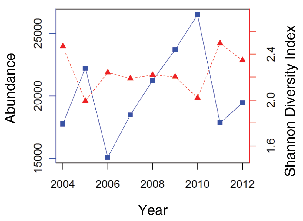
Figure 2. Waterfowl abundance and Shannon diversity index.
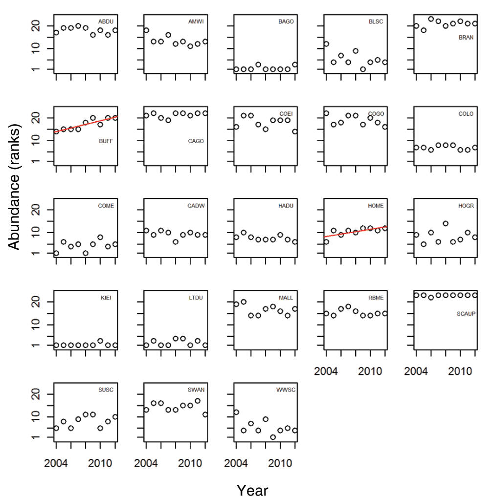
Figure 3. Species ranked abundances.
Our final NMDS fit had four dimensions and a stress value of 0.1449 (Figure 4A), and is well within the acceptable stress limits of NMDS (Clarke, 1993; Kruskal & Wish, 1978). The final four dimensional NMDS was selected based on a considerable decrease in stress from the three dimensional solution; however, a fifth dimensional solution offered only a slight decrease in stress. Sites in the NMDS plot that are closer in ordination space are more similar in species composition. As the distance between points increases, the species composition becomes more dissimilar. Our final presentation of the NMDS rotated the data so that greatest distance between site scores are plotted on NMDS axis 1. There is some spatial clustering of survey sections across the first two NMDS axes. Sections 1 and 6 are concentrated on the left side of the NMDS axis 1, while sections 2 and 3 are predominantly on the right side. Sections 4 and 5 are located approximately in the middle, as they are in actual Bay position.
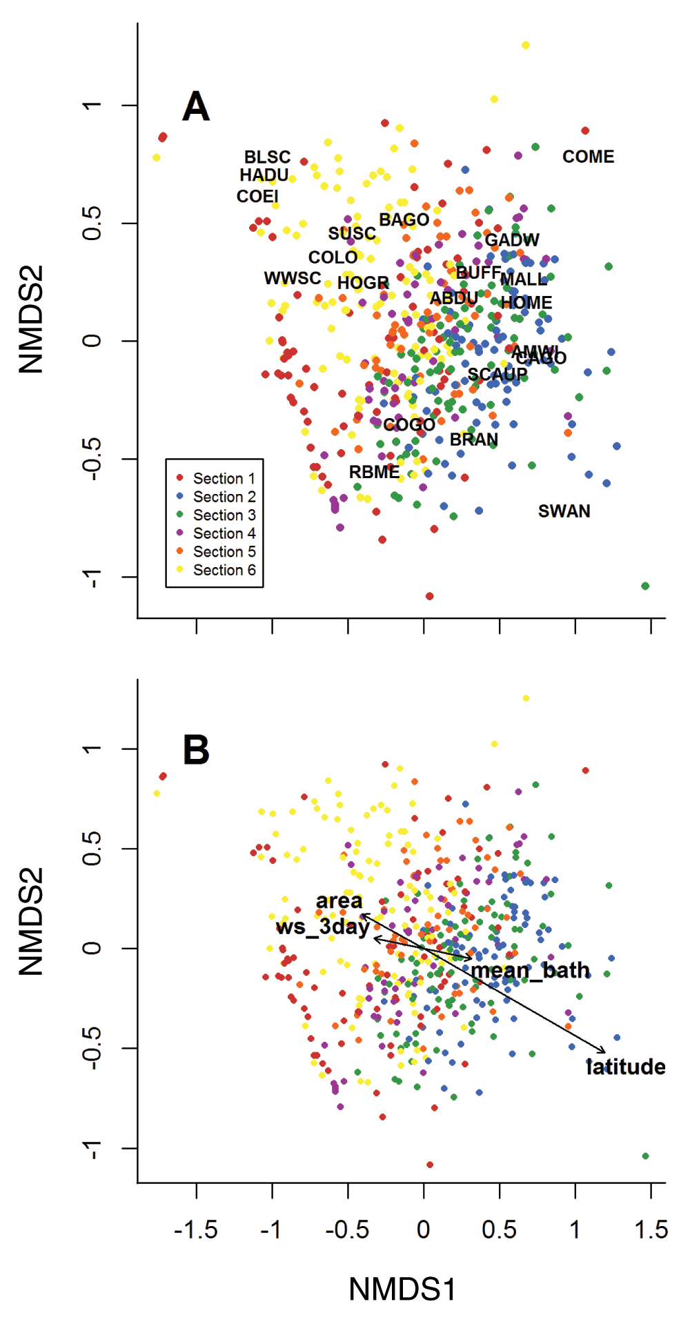
Figure 4. Final NMDS results.
The circles illustrate the location of a single site for each surveyed year. The sites are color-coded by section. Figure 4A: Species locations are illustrated with four-letter abbreviation. Long-tailed duck and king eider were rare and therefore plotted a considerable distance from all other species. To increase the legibility of this figure, we zoomed in on the main cluster. However, long-tailed was 0.09 on NMDS 1 and -1.54 on NMDS 2, and king eider was -1.041 and -1.45. Figure 4B: Bi-plot of NMDS axis one and two with vectors of significant environmental variables overlaid. The arrow’s direction illustrates the environmental gradient and the length is proportional to the correlation strength between the variable and the NMDS (See Table 3).
Table 3. Results of final NMDS.
| Variable | NMDS 1 | NMDS 2 |
|---|
|
Latitude***
| 0.916 | -0.401 |
|
mean_bath**
| 0.987 | -0.160 |
|
Area***
| -0.920 | 0.392 |
|
NAO.12
| 0.247 | -0.969 |
|
NAO.11
| -0.0618 | 0.998 |
|
NAO.win
| 0.145 | -0.989 |
|
WS_3day**
| -0.988 | 0.157 |
|
WS_30day
| 0.600 | 0.799 |
|
WD_day**
| 0.563 | -0.826 |
|
WD_day_b4*
| -0.335 | 0.942 |
Species location in the ordination space can approximate how species sort into habitat types along the spatial gradient in the Bay (Figure 4a). The upper left of the ordination space reflects predominantly open ocean, deep-water sites (sections 1 and 6). In line with the habitat location in ordination space, indicator species of deeper water oceanic habitat (e.g. Harlequin Duck (Histrionicus histrionicus) and Common Eider (Somateria mollissima)) are also positioned in the upper left hand corner of the ordination. Northern sites in the Bay are more shallow and marsh-like (sections 2 and 3), with species indicative of this habitat type (e.g. Atlantic Brant (Branta bernicla) and Canada Goose (Branta canadensis)).
After the removal of correlated variables, ten ancillary variables were fit to the NMDS results (Table 3). Only latitude, mean bathymetry, area, and the average wind speed three days prior to the survey were significantly correlated to the NMDS (Figure 4B). Wind speed the day of the survey and day before were slightly less significant. Although not significant, the NAO index for November, December, and winter average showed strong relationships with NMDS axis 2.
Most sections’ locations in the ordination space did not change drastically between years; they remained in the same relative location of the ordination (Figure 5). The relative stability of sections in ordination space among years indicates that communities had consistent species composition between years. Section 2 shifted the most among years, especially between 2008 and 2009 (Figure 5). Additionally, when compared to the other sections, section 2 had the greatest between group average distances through the duration of this study.
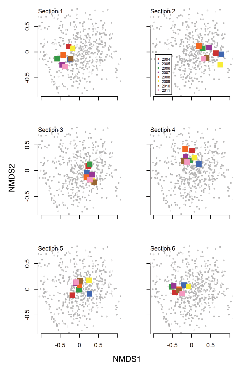
Figure 5. Final NMDS illustrating average community ordination location of section by year.
Illustrates where the section exists in the overall ordination space and how that position changes through the study period. The gray symbol represent the site locations- as were presented in Figure 4. In other words, all Figure 5 subplots are constructed from the NMDS presented above. Here we have added the average position for each section (based on all sites within that section) by year.
Discussion
Our community level analysis allowed us to establish the expected spatial and temporal structure of the Bay’s winter waterfowl communities which can be used to monitor future environmental changes. Spatially, the NMDS analysis formalized several aspects of the Bay’s waterfowl community that were previously understood only anecdotally, and provided a clear depiction of the community spatial structure across the Bay. NMDS results in conjunction with the baseline conditions identified in this study could be particularly useful in identifying any future changes in waterfowl community structure in this region and change in the Bay’s overall health.
In the upper portions of the Bay (sections 2 and 3), waterfowl habitat is characterized by shallow, salt-marsh dominated coves and sheltered coves and shorelines with ample freshwater inputs. These sites mapped predominantly on the right-side of the NMDS (Figure 4). Dabbling duck species such as Mallard (Anas platyrhynchos) and American Black Duck (Anas rubripes) use salt-marsh sites at high tide for cover, protection from predators, and feeding, and as sites for roosting at low tide (Bellrose, 1980). Several smaller diving ducks, including benthic-feeding Bufflehead and piscivorous Hooded Merganser use sheltered coves and shorelines for feeding during the day (McKinney, 2004). Canada Goose and Mute Swan (Cygnus olor) also utilize these sites as they presumably provide ready access to submerged aquatic vegetation on which these species feed (Mowbray et al., 2002). An urban center (city of Providence) and several expansive suburban cities are located in close proximity to the upper Bay sites, and it is in this region of the Bay where urban development would be expected to most influence waterfowl distribution.
The middle portion of the Bay is characterized by an increase in deeper, open water habitats, which continue towards the Bay mouth where they are supplemented by rocky shoreline habitats. These sites concentrated on the left-side of the NMDS (Figure 4, color-coded red and yellow). Open-water species such as Red-breasted Merganser (Mergus serrator), Common Goldeneye (Bucephal clangula), Scoter species (Melanitta spp.), and Common Eider use this region of the Bay. These species have larger body sizes that enable them to dive in deeper water to take advantage of prey not found in shallow water areas (e.g., Blue Mussel, Mytilus edulis), and of benthic prey such as crabs that migrate to deeper water during winter (Ehrlich et al., 1988). Harlequin Duck uses rocky shoreline habitats found near the mouth of the Bay that reflect their northern rocky stream breeding sites and where they can feed on benthic invertebrates such as amphipods (Robertson & Ian Goudie, 1999). The lower Bay sites are currently less impacted by adjacent urbanization effects as shorelines tend to be more sparsely populated. However, knowledge of baseline conditions could lend insight into interpreting data from future monitoring and aid in identifying any impacts of increased urbanization, or changes in waterfowl community structure resulting from displacement of upper Bay species.
In addition to species’ life history strategies, climatic factors can potentially influence waterfowl distribution in estuaries. In our study, wind speed, averaged over the three day period before sampling, was the only significant dynamic variable included in the final NMDS. This too reinforces what was communicated anecdotally about the movement of waterfowl through the Bay. Large groups of birds will shift their location in the Bay during prolonged high wind events, such as nor’easters. Typically before and during large storms, birds will relocate to the leeward side of islands or into wind protected coves. Due to global climate change, nor’easter frequency and intensity have increased on a global scale (Yohe & Hope, 2013). It is assumed that Narragansett Bay will be impacted by this increase in predicted probability of severe winter events. Our study suggests waterfowl respond to short-term changes in wind speed, and it will be of interest to monitor how waterfowl respond to any increase in both intensity and frequency of extreme wind events.
We observed a small, yet significant, increase in the ranked abundance of Hooded Merganser, and an even more apparent upward trend of the Bufflehead population. The Bufflehead trend may be the effect of increased level of protection for this species. In the early 20th century, Bufflehead populations were in decline due to over harvest and in response received increased protection through such means as reduced bag limits (Gauthier, 1993). In addition, Bufflehead nesting boxes were installed to compensate for loss of breading habitat (Erskine, 1960; Owen & Black, 1990). Population numbers have been growing steadily since, and perhaps this rebound could explain the increasing trend we saw in Narragansett Bay. Since we used ranked abundance, we hypothesize that the elevated conservation status of Bufflehead and subsequent population growth is providing the Bufflehead a competitive advantage in the Bay. However, more research is needed to fully understand the dynamics and drivers of the changes in Bufflehead populations in the Bay.
As we move forward with our monitoring, the NMDS approach can provide a useful means to compare future survey data with baseline conditions established during the first ten years of the survey. The NMDS provides a statistical framework to analyze monitoring data at the site and section level, but in context of the entire Bay (Faith et al., 1987). Due to random noise, we expect the position of the site or the average position of the section (as in Figure 5) to undergo relatively small changes in ordination space from year to year. In contrast, locations that jump from one year to the next, or that display a trajectory through NMDS space through time may indicate environmental forcing that is more than random.
For example, the relatively large shifts of section 2 between years may be a characteristic of this particular section; it is thought that waterfowl communities in this part of the Bay vary greatly according to the intensity of winter and amount of ice (McKinney, 2004). However, large shifts among years or over the course of several years may be an indicator of environmental change. Additionally, if we see more variability in the amount of ice in this section, it may be more difficult to define a collective waterfowl community for this section. The turnover between years might simply overwhelm any potential community signal. To highlight the effectiveness of the method for monitoring, we already know from this baseline analysis that section 2 is an area that requires special consideration in the future.
Although the NMDS shows promise as an effective statistical framework, there are obvious limitations to our approach. First and foremost, annual surveys provide discrete snapshots of the Bay’s waterfowl community through time. We survey one day a year, and only in the winter when these species are present. We do not have a quantitative estimate of the amount of variability data arising from either short-term (i.e., daily) or longer-term (weekly or monthly) movements of individuals among sites, or into and out of our study area. Because of this, our ability to detect change in community composition may require data collection over an extended time period. Yet despite these shortcomings, the ease of data collection and robustness of the NMDS method make it a viable long-term monitoring option.
In this study we proposed an approach to analyzing long-term waterfowl monitoring data in order to establish baseline conditions against which future trends in community composition and habitat utilization can be compared. This approach provides a quantitative yet visual means to represent baseline community structure and observed patterns of waterfowl distribution, and provides an easily interpreted series of templates against which future observations or patterns of change can be evaluated. Our approach was developed for waterfowl Narragansett Bay, but can be applied to other estuaries and potentially other species, although environmental factors in the model may need to be modified to reflect those relevant to the species investigated. Overall, our approach will help facilitate the use of waterfowl populations, as well as other relevant species, to monitor the environmental health of a large bay.
Data availability
F1000Research: Dataset 1. Environmental data, 10.5256/f1000research.6080.d42953 (Kreakie et al., 2014a).
F1000Research: Dataset 2. Winter waterfowl survey, 10.5256/f1000research.6080.d108872 (Kreakie et al., 2014b).
Author contributions
RM designed, implemented, and supervised all waterfowl surveys. Additionally, RM curates all survey data. BK conducted coding and analysis, and prepared the manuscript for publication. KW has participated in waterfowl surveys. All authors were involved in developing conclusions and revising the manuscript. All authors agree to the final content.
Competing interests
No competing interests were disclosed.
Grant information
The author(s) declared that no grants were involved in supporting this work.
Acknowledgements
We would like to thank the myriad of biologists and environmental scientists who participated in the Narragansett Bay Winter Waterfowl Survey during the time of the study especially Peter Paton, Scott McWilliams, Jay Osenkowski, Kenny Raposa, Tim Gleason, Jay Winiarski, Kathy Vigness-Raposa, Bob Kenney, Walter Berry, Jonathan Serbst, Denise Champlin, Barbara Sherman, Wayne Munns, Ed Dettman, Carol Trocki, Heather Hopkins, and Cathy Wigand for special assistance in collecting waterfowl survey data. Additionally, we would like to thank Dwaine Kreakie, Anne Kuhn, Nathan Smucker, and Bryan Milstead for their helpful comments during the development of this manuscript. This paper has not been subjected to Agency review. Therefore, it does not necessary reflect the views of the Agency. This is contribution number ORD-006396 of the Atlantic Ecology Division, Office of Research and Development, National Health and Environmental Effects Research Laboratory.
Faculty Opinions recommendedReferences
- Amat JA, Green AJ:
Waterbirds as Bioindicators of Environmental Conditions.
Conservation Monitoring in Freshwater Habitats.
2010; 45–52. Publisher Full Text
- Assessment ME: Millennium ecosystem assessment.
Ecosystems.
2003. Reference Source
- Assessment ME: Ecosystems and human well-being: Synthesis. Island Press Washington, DC, 2005. Reference Source
- Austin JE, Buhl TK, Guntenspergen GR, et al.:
Duck populations as indicators of landscape condition in the prairie pothole region.
Environ Monit Assess.
2001; 69(1): 29–47. PubMed Abstract
| Publisher Full Text
- Austin M:
On non-linear species response models in ordination.
Vegetatio.
1976; 33(1): 33–41. Publisher Full Text
- Bellrose FC:
Ducks, Geese and Swans of North America. Stackpole, Harrisburg, PA.
1980. Reference Source
- Calabretta CJ, Oviatt CA:
The response of benthic macrofauna to anthropogenic stress in Narragansett Bay, Rhode Island: a review of human stressors and assessment of community conditions.
Mar Pollut Bull.
2008; 56(10): 1680–1695. PubMed Abstract
| Publisher Full Text
- Caron CM, Paton PW:
Population trends and habitat use of Harlequin Ducks in Rhode Island.
J Field Ornithol.
2007; 78(3): 254–262. Publisher Full Text
- Clarke K, Ainsworth M:
A method of linking multivariate community structure to environmental variables.
Mar Ecol Prog Ser.
1993; 92: 205–219. Publisher Full Text
- Clarke KR:
Non-parametric multivariate analyses of changes in community structure.
Australian J Ecol.
1993; 18(1): 117–143. Publisher Full Text
- Codiga DL, Stoffel HE, Deacutis CF, et al.:
Narragansett Bay hypoxic event characteristics based on fixed-site monitoring network time series: Intermittency, geographic distribution, spatial synchronicity, and interannual variability.
Estuaries and Coasts.
2009; 32(4): 621–641. Publisher Full Text
- DeLuca WV, Studds CE, Rockwood LL, et al.:
Influence of land use on the integrity of marsh bird communities of Chesapeake Bay, USA.
Wetlands.
2004; 24(4): 837–847. Publisher Full Text
- Dixon P:
VEGAN, a package of R functions for community ecology.
J Veg Sci.
2009; 14(6): 927–930. Publisher Full Text
- Ehrlich PR, Dobkin DS, Wheye D:
The birder’s handbook: A field guide to the natural history of North American birds: including all species that regularly breed north of Mexico. In Simon & Schuster (New York), 1988. Reference Source
- Erskine AJ:
A discussion of the distributional ecology of the Bufflehead (Bucephala albeola; Anatidae; Aves) based upon breeding biology studies in British Columbia, 1960. Reference Source
- Faith DP, Minchin PR, Belbin L:
Compositional dissimilarity as a robust measure of ecological distance.
Vegetatio.
1987; 69(1–3): 57–68. Publisher Full Text
- Findlay CST, Bourdages J: Response time of wetland biodiversity to road construction on adjacent lands.
Conserv Biol.
2000; 14(1): 86–94. Publisher Full Text
- Gabrey SW, Afton AD:
Composition of breeding bird communities in gulf coast chenier plain marshes: effects of winter burning.
Southeast Nat.
2004; 3(1): 173–185. Publisher Full Text
- Gauthier G:
Bufflehead (Bucephala albeola). In The Birds of North America. A. Poole and F. Gill, editor, 1993. Publisher Full Text
- Hurrell JW:
Decadal trends in the North Atlantic Oscillation: regional temperatures and precipitation.
Science.
1995; 269(5224): 676–679. PubMed Abstract
| Publisher Full Text
- Karydis M:
Scaling methods in assessing environmental quality: a methodological approach to eutrophication.
Environ Monit Assess.
1992; 22(2): 123–136. PubMed Abstract
| Publisher Full Text
- Koper N, Schmiegelow FKK:
A multi-scaled analysis of avian response to habitat amount and fragmentation in the Canadian dry mixed-grass prairie.
Landsc Ecol.
2006; 21(7): 1045–1059. Publisher Full Text
- Kreakie B, Winiarski K, McKinney R:
Dataset 1 in “Developing a wintering waterfowl community baseline for environmental monitoring of Narragansett Bay Rhode Island”.
F1000Research.
2014a. Data Source
- Kreakie B, Winiarski K, McKinney R:
Dataset 2 in “Developing a wintering waterfowl community baseline for environmental monitoring of Narragansett Bay Rhode Island”.
F1000Research.
2014b. Data Source
- Kruskal JB:
Nonmetric multidimensional scaling: a numerical method.
Psychometrika.
1964; 29(2): 115–129. Publisher Full Text
- Kruskal JB, Wish M:
Multidimensional scaling. Sage. 1978. Reference Source
- Kushlan JA:
Colonial waterbirds as bioindicators of environmental change.
Colonial Waterbirds.
1993; 16(2): 223–251. Publisher Full Text
- Loring PH, Paton PW, McWilliams SR, et al.:
Densities of Wintering Scoters in Relation to Benthic Prey Assemblages in a North Atlantic Estuary.
Waterbirds.
2013; 36: 144–155. Publisher Full Text
- Maisonneuve C, Bélanger L, Bordage D, et al.:
American black duck and mallard breeding distribution and habitat relationships along a forest-agriculture gradient in southern Quebec.
J Wildl Manage.
2006; 70(2): 450–459. Publisher Full Text
- Matsinos YG, Wolff W:
An individual-oriented model for ecological risk assessment of wading birds.
Ecol Modell.
2003; 170(2–3): 471–478. Publisher Full Text
- McKinney R:
Habitat relationships of waterfowl wintering in Narragansett Bay.
Rhode Island Naturalist.
2004; 11: 3–6. Reference Source
- McKinney R, McWilliams SR:
A new model to estimate daily energy expenditure for wintering waterfowl.
The Wilson Bulletin.
2005; 117(1): 44–55. Reference Source
- Minchin PR:
An evaluation of the relative robustness of techniques for ecological ordination. In Theory and models in vegetation science.
Springer, 1987; 8: 89–107. Publisher Full Text
- Mochizuki M, Hondo R, Kumon K, et al.:
Cadmium contamination in wild birds as an indicator of environmental pollution.
Environ Monit Assess.
2002; 73(3): 229–235. PubMed Abstract
| Publisher Full Text
- Mowbray TB, Ely CR, Sedinger JS, et al.:
Canada Goose (Branta canadensis). In The Birds of North America Online. A. Poole, editor Cornell Lab of Ornithology. 2002. Publisher Full Text
- Nixon SW, Fulweiler RW:
Ecological footprints and shadows in an urban estuary, Narragansett Bay RI (USA).
Reg Environ Change.
2012; 12(2): 381–394. Publisher Full Text
- Nixon SW, Fulweiler RW, Buckley BA, et al.:
The impact of changing climate on phenology, productivity, and benthic–pelagic coupling in Narragansett Bay.
Estuar Coast Shelf Sci.
2009; 82(1): 1–18. Publisher Full Text
- O'Connell TJ, Jackson LE, Brooks RP:
Bird guilds as indicators of ecological condition in the central Appalachians.
Ecol Appl.
2000; 10(6): 1706–1721. Reference Source
- Oksanen J, Kindt R, Legendre P, et al.:
The vegan package. Community ecology package. 2007. Reference Source
- Owen M, Black JM:
Waterfowl ecology. Blackie Glasgow. 1990.
- Pagano AM, Arnold TW:
Detection Probabilities for Ground-Based Breeding Waterfowl Surveys.
J Wildl Manage.
2009; 73: 392–398. Publisher Full Text
- Pastore CL:
From Sweetwater to Seawater: An Environmental History of Narragansett Bay 1636–1849. In University of New Hampshire, 2011. Reference Source
- R Development Core Team:
R: A Language and Environment for Statistical Computing. In R Foundation for Statistical Computing, Vienna, Austria 2013. Reference Source
- Ribeiro C, Vollaire Y, Sanchez-Chardi A, et al.:
Bioaccumulation and the effects of organochlorine pesticides, PAH and heavy metals in the Eel (Anguilla anguilla) at the Camargue Nature Reserve, France.
Aquat Toxicol.
2005; 74(1): 53–69. PubMed Abstract
| Publisher Full Text
- Robertson GJ, Ian Goudie R:
Harlequin Duck (Histrionicus histrionicus). In The Birds of North America Online. A. Poole, editor Cornell Lab of Ornithology 1999. Reference Source
- Temple SA, Wiens JA:
Bird populations and environmental changes: can birds be bio-indicators.
American Birds.
1989; 43: 260–270. Reference Source
- Tyrrell T, Devitt M, Smith L:
The Economic Importance of Narragansett Bay.
Final Report for RIDEM and Rhode Island SeaGrant.
1994.
- Urban DL:
A modeling framework for restoration ecology. Foundations of restoration ecology. Edited by DA Falk, MA Palmer, and JB Zedler. Island Press, Washington, DC 2006; 238–256. Reference Source
- Visbeck MH, Hurrell JW, Polvani L, et al.:
The North Atlantic Oscillation: past, present, and future.
Proc Natl Acad Sci U S A.
2001; 98(23): 12876–12877. PubMed Abstract
| Publisher Full Text
| Free Full Text
- Yohe G, Hope C:
Some thoughts on the value added from a new round of climate change damage estimates.
Clim Change.
2013; 117: 451–465. Publisher Full Text
Comments on this article Comments (0)