Keywords
Anomalies, ARIMA, Climate Change, Extreme Temperature.
This article is included in the Climate gateway.
Anomalies, ARIMA, Climate Change, Extreme Temperature.
Climate change affects ecosystems, communities and individual organisms. Plants, for instance, are primary producers which often adapt to extreme environmental conditions with different strategies, especially in arid areas1. Many plant species in the region exhibit adaptation to extremes of heat and drought. In the United Arab Emirates (UAE), for example, vegetation may be considered already highly resilient to climate change2. However, some of these species may be close to their physiological tolerance limits. This presents a natural challenge to living organisms1. As such, the present study attempted to assess temperature patterns, in order to further investigate the overall impact of climate change on land cover and land use dynamics.
With the expected change in climate, such species will experience additional stressors, leading to reduced land cover and therefore degradation due to overgrazing and land use change3. The UAE climate is classified as hyper-arid, with different bio-climatic zones4 and hence a variety of environmental challenges, including very low land cover coupled with major shifts in land use5. In the north-eastern regions of the UAE, the average precipitation is higher while the temperatures are lower4. Additionally, and in comparison, these conditions are similar to those of other areas in the Arabian Gulf, where the mean annual temperatures increase along a north–south gradient from Kuwait and Riyadh towards Dibba and Muscat. But there may be patterns in rainfall1 as well as temperature. Consequently, there exists a need to assess patterns in climatic conditions, especially with the potential impact of climate change regionally as well as globally.
Climate change has also been impacting the UAE. The UAE’s tropical and dry climate is subject to impacts from the Indian Ocean across the Sea of Oman6. Across the UAE, using 2012 statistics performed by the Ministry of Environment and Water6, the temperature increased by 0.6°C to 2.7°C. Raising temperature, for instance, has been observed in Abu Dhabi with an increase of around 2.3°C between 1982 and 2013, while an increase of 2.7°C between 2013 and 1975 in Dubai6. Other cities have also experienced increases between 0.6 and 1.8°C during the past 30–40 years6. The Gulf temperatures are also changing. During the last 50 years, the Arabian gulf surface temperature increased 0.2°C per decade. In other parts of the Arabian Gulf, the increase was estimated to be thrice the global average or 0.6°C per decade7. Additionally, sea surface temperatures, sea surface salinity and sea level were projected to change8. Wind patterns were also estimated to change across the region8, which normally affects temperature. Further, and in terms of energy supply, for instance, the UAE 2030 strategic plan envisages to generate more than quarter of its electricity from clean energy sources6. It is therefore believed that predicting temperature changes in different parts of the UAE is necessary, especially with the widespread use of time series analyses.
Auto Regressive Integrated Moving Average (ARIMA) based models are used in time series analyses to predict changes in climatic conditions9. ARIMA is a class of models that predicts a given time series based on historical values10. It is a modeling approach in which three predictors (i.e. p, d and q) are calculated to be the basis for the forecasting process. ARIMA has been used to predict solar radiation9, weather11, evapo-transpiration12, wind speed13 and rain & temperature14. Generally, the goodness of fit of the model is tested against standardized residuals, the auto-correlation function (ACF), and the partial autocorrelation function (PACF). The ACF plot shows the correlation of the series with itself at different lags, while the PACF plot shows the amount of auto-correlation at a given lag that is not explained by lower-order auto-correlations15. For evaluation purposes, the model is compared with Monte Carlo simulations, using mean absolute error, R-square error, root mean square error and sum of square error. ARIMA performed better than Adaptive Network Based Fuzzy Inference System in a study to forecast weather in Bangladesh11, Arca et al.12; however, a lower performance in modeling evapo-transpiration when compared to other modeling approaches was reported. The relationship between circulation type frequencies and temperature indices revealed a warming effect for both winter and summer16. The number of days with extreme high temperatures in the wheat growing regions of the Netherlands, for instance, significantly increased since the early 1900s17, while the number of extreme low temperature events dropped during the same period. It is therefore useful to use standardized indices such as STI (standardized temperature index) to compare historical values across and within years.
STI is calculated in the same way as was reported by McKee and Kleist18 for the standardized precipitation index (SPI). Specifically, SPI was calculated based on the Palmer Drought Severity Index, which is widely used for drought forecasting19,20 and evapo-transpiration assessment21. Such standardization process allows for comparison across space and time at any location22. Both SPI and STI have been developed into RStudio packages23, and in the present work we limit our analyses to STI. The basis of which has been that assessing temperature anomalies may be useful for climate forecasting purposes. Temperature anomalies may also be used as indicators of climate change24. Trends in annual mean temperature anomalies for the globe show rapid and steady warming through the early 1940s25. As a consequence, the present study aimed to assess the use of ARIMA modeling approach coupled with STI to predict temperature anomalies across four bio-climatic UAE regions. Historical data is used for the ARIMA forecasting and STI categorization of climatic events.
The present investigation centers around average monthly temperatures collected from NOAA Land-Based Station Data26 for Abu Dhabi (24.45N, 54.38E), Al-Ain (24.13N, 55.80E), Dubai (25.20N, 55.27E) and Sharjah (25.35N, 55.42E). Each of these locations was intended to represent a different bio-climatic zone within the UAE; they have different climatic conditions and represent different soil/vegetation associations as classified in the UAE soils Atlas27. The time frame of the historical data is between January 1997 and December 2017 (as was available from NOAA station data), while the forecast is planned for 2030, or 13 years into the future. The year 2030 constitutes a major important target, for which the UAE set a strategic plan in relation to various development aspects, including expectations for efficient climate change mitigation and adaptation.
The data for each of the four bio-climatic regions was transformed into a time series data frame using RStudio "forecast" and "tseries" packages. The data was then converted into a differencing series to make it stationary on mean and remove the trend. Additionally, it was log transformed in order to make the data stationary on variance. The plotting of the ACF and PACF to identify potential AR and MA model predictors (i.e. p and q). The idea is to identify the presence of AR and MA components in the residuals. The "d" predictor is used to reflect differencing in the ARIMA model. Where p is the number of autoregressive terms; d is the number of nonseasonal differences and q is the the number of moving-average terms.
The "csv" files for each zone were loaded into RStudio, then the "forecast" package was loaded. The residuals of the ARIMA analyses were graphed using the "plot.ts" function in the "tseries" package. The "acf" and "pacf" functions were executed for all studied zones. In order to identify the best fit, the "auto.arima" function was used and the best model predictors (p, d and q) were then identified. The plots presented here for each location is a forecast for 13 years (until 2030) using the best fit, and a range between ± two standard errors.
The standardized temperature index (STI) was used to categorize the changes in temperature across all four bioclimatic zones. STI was calculated using the historical climate data (i.e. 1997–2017). STI is an index representing the probability of occurrence of a temperature value when compared with values on a longer period. It is calculated based on the Palmer Drought Severity Index22. The median is used as a point of reference to identify the STI events. These events are relative to the temperatures at a given location, but STI permits for comparisons at different locations22. To classify temperature anomalies, the STI events are categorized as detailed in Table 1.
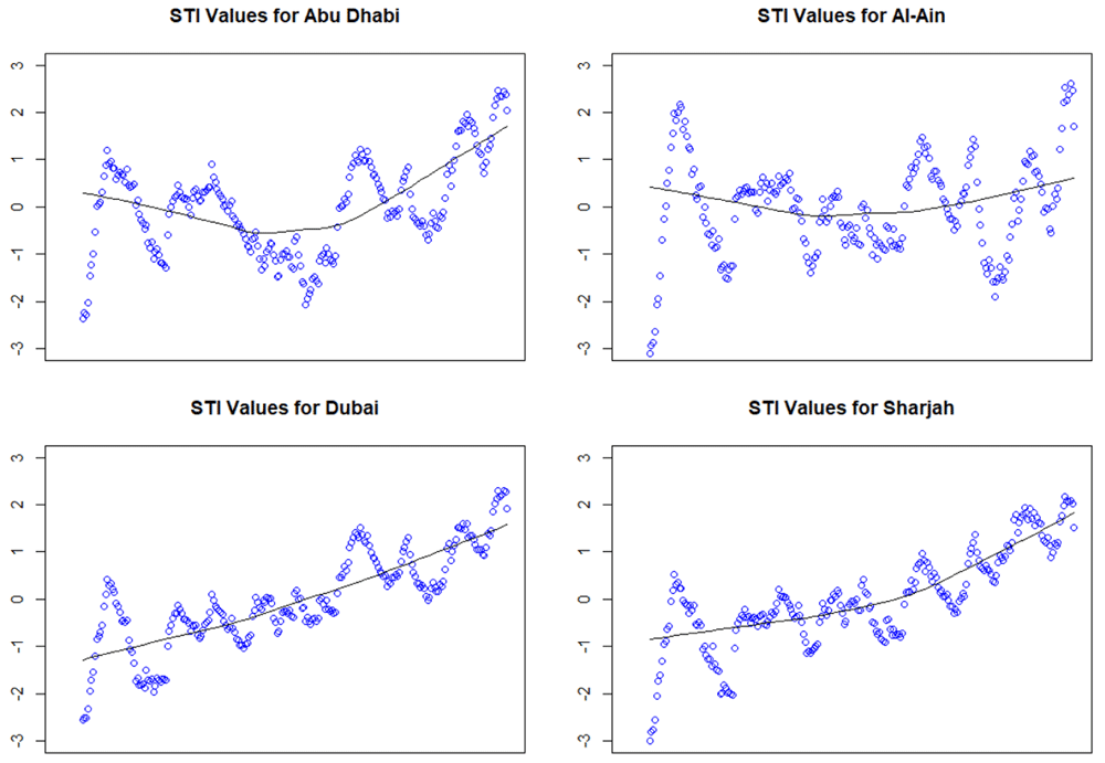
Raw data was first processed for all four bio-climatic zones using the pivot table option in Excel (Version 16.0.4266.1001). The "csv" file for each zone was then uploaded to RStudio to analyse the data using "STI" package (Version 0.1). STI command was used and the time scale was set to 12. That is the average of the eleven first months is used for month twelve (i.e. the first eleven values will be "NA")22. The "stiEvents" function was then used to quantify the number of entries in each of the STI categories listed in Table 1. The "scatter.smooth" command was finally used to draw the scatter plots referred to in Figure 10.
Boxplots were generated using RStudio from the original temperature data (Figure 1). Abu Dhabi (top) tended to have highest median temperature when compared to Al-Ain, Dubai and Sharjah with averages of 36.2°C, 29.9°C, 29.6°C and 28.6°C, respectively. While Al-Ain, with 12.5°C, has the largest inter-quartile range (IQR) vs 12.1°C, 10.6°C and 11.4°C, for Adu Dhabi, Dubai and Sharjah, respectively.
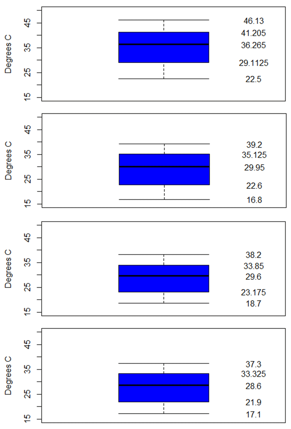
The 5 boxplot values (listed on the right side top to bottom) are the maximum, 75th quartile, median, 25th quartile and minimum.
The lowest minimum temperature recorded was 16.8°C for Al-Ain, while the highest minimum was for Abu Dhabi (22.5°C). The pattern observed for the highest value of maximum temperatures were 46.1°C, 39.2°C, 38.2°C and 37.3°C for Abu Dhabi, Al-Ain, Dubai and Sharjah, respectively.
First the variance and mean are stationary as shown in the differentiated temperature in Figure 2–Figure 4 and Figure 5 (top left insets). This also gives us the idea that the "I" term (or integrative part) in the ARIMA model will be equal to 1 as 1st level was making the series stationary, for all four bio-climatic regions.
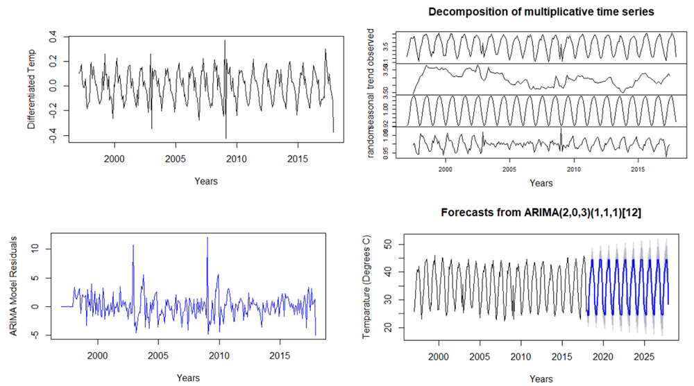
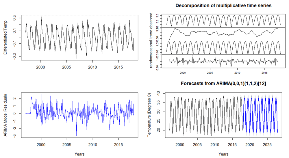
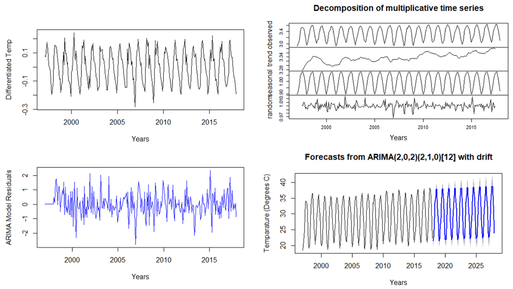
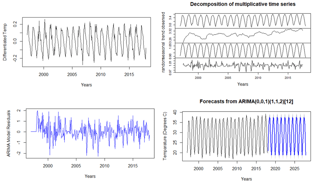
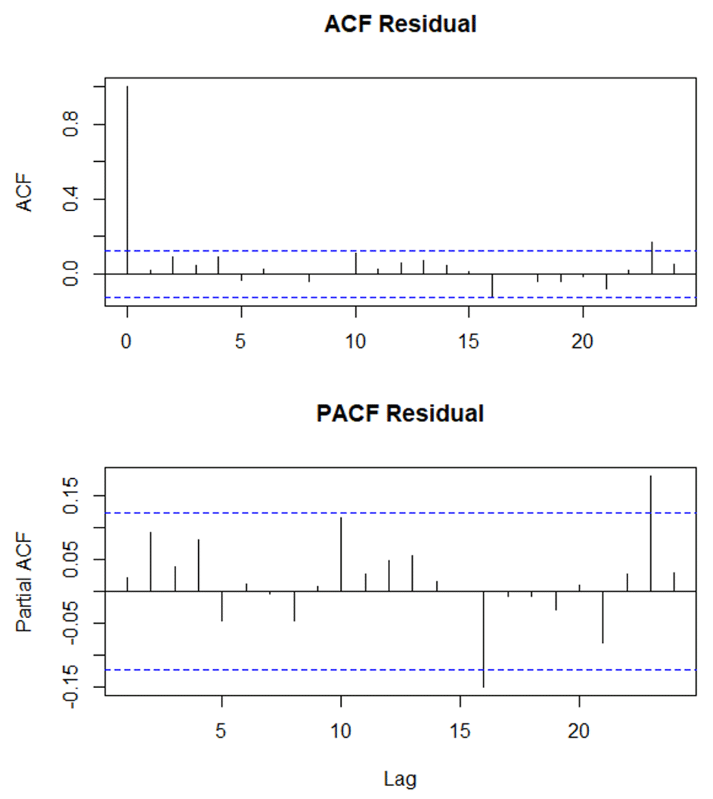
The residual graphs for all four zones also suggest stationary data. This is shown in Figure 2–Figure 4 and Figure 5 (bottom left insets). Additionally, the Box-Ljung test, which is used to test for auto-correlation at P> 0.05, is presented in Table 2. For all four zones, the Box-Ljung test was carried at three different lags (5, 10 and 15). All runs were not significant at P> 0.05; which is an indication of the absence of auto-correlation. The x-squared for 5 lags were 3.7, 9.7, 5.8 and 5.2 for Abu Dhabi, Al-Ain, Dubai and Sharjah, respectively (Table 2).
| Bio-Climatic Zones | X-squared | df | p-values |
|---|---|---|---|
| Abu Dhabi | 3.7 | 5 | 0.59 |
| Al-Ain | 9.8 | 5 | 0.08 |
| Dubai | 5.8 | 5 | 0.33 |
| Sharjah | 5.2 | 5 | 0.39 |
The ARIMA forecasting assessment suggests that all zones under investigation, except Dubai, are predicted to have constant trend of average temperatures until 2030. For Dubai (Figure 4 lower right inset), however, there is a slightly increasing trend. The ARIMA predictors (i.e. p,d and q) are in the order of 2,0,2 (Figure 4 lower right inset).
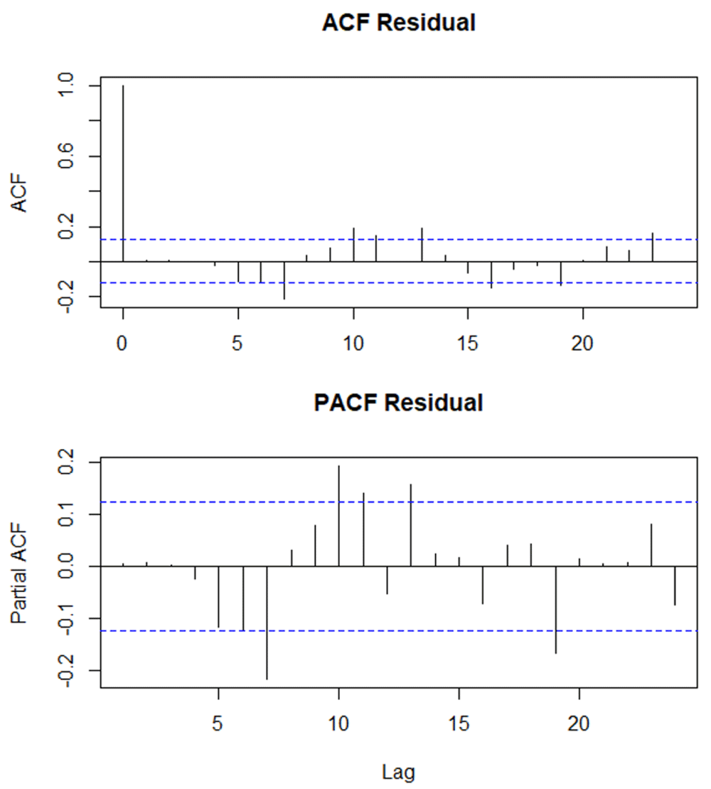
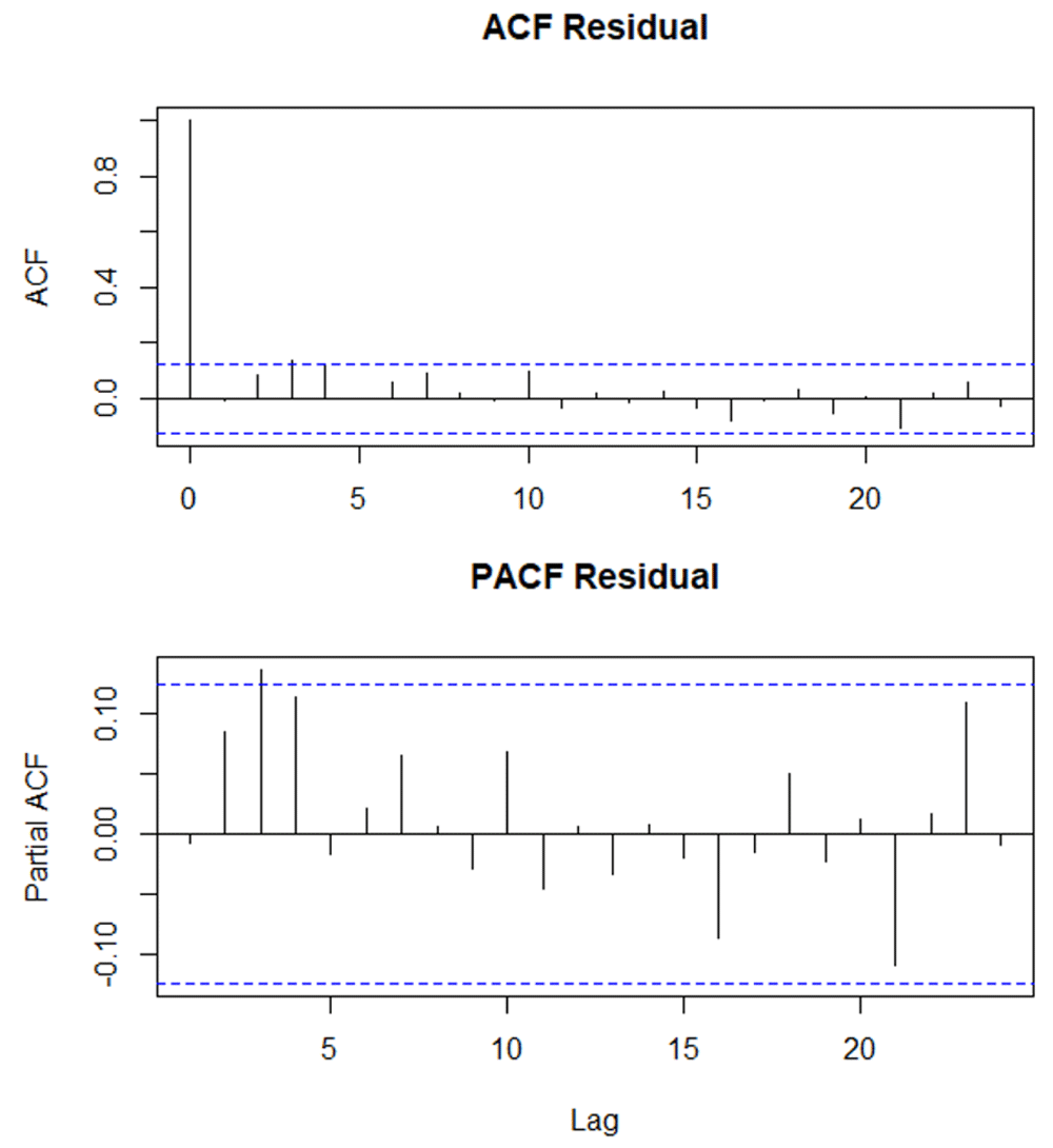
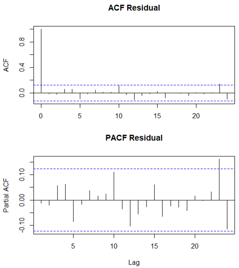
The ACF and PACF graphs are shown in Figure 6–Figure 8 and Figure 9 for Abu Dhabi, Al-Ain, Dubai and Sharjah, respectively. Since mostly there are no spikes outside the insignificant zone for both ACF and PACF plots, it can be concluded that residuals are random. In other words, our ARIMA models are appropriate in forecasting UAE bio-climatic zones. It is important to note that ACF plots can help determine the order of the MA (q) component of the model. While PACF plots assist in identifying the order of the AR (p)component of the model.
STI events from historical climatic data (1997–2017) are summarized in Table 3. All four bio-climatic zones had high proportions of "near normal" events between 1997 and 2017. Sharjah and Al-Ain had the highest occurrences of such events, with averages of 171 and 168, respectively. Extremely hot events are highest for Al-Ain (i.e. 9), followed by Abu Dhabi, Dubai and Sharjah (8, 7 and 5, respectively). What is noteworthy are the differences among the studied zones for "moderately hot" events. Dubai has the highest number of such events (i.e. 34), while Abu Dhabi has experienced only 12 "moderately hot" events. The average number of events classified as "very cold" are predicted to be 20, 10, and 8, for Dubai, Sharjah, and for each of Abu Dhabi and Al-Ain, respectively.
| STI Events | Abu Dhabi | Al-Ain | Dubai | Sharjah |
|---|---|---|---|---|
| Extremely hot | 8 | 9 | 7 | 5 |
| Moderately hot | 12 | 19 | 34 | 16 |
| Near normal | 162 | 168 | 163 | 171 |
| Moderately cold | 34 | 25 | 6 | 13 |
| Very cold | 8 | 8 | 20 | 10 |
| Extremely cold | 5 | 5 | 4 | 7 |
The STI values for each bio-climatic zone were graphed using "scatter.smooth" option in Rstudio (Figure 10). As time passed, Abu Dhabi and Al-Ain seem to have a general distribution of the STI values around zero (Figure 10 top two insets). Overall, Abu Dhabi had a more pronounced trend, with a dip in STI values mid-way through the study period. In Abu Dhabi the extreme STI values were recorded during the last few years of the study period (Figure 10 top left inset). Al-Ain, however, has a flatter trend. More specifically, Al-Ain has experienced higher than usual positive STI values during the last few months of 2017 (Figure 10 top right inset). For both Abu Dhabi and Al-Ain, there was also more than usual negative STI values (i.e. colder than normal) early during the study period. While Dubai and Sharjah had more STI values to the positive range direction (Figure 10 bottom two insets), toward the end of the study period (1997–2017). It may be an indication that historically, both Dubai and Sharjah have experienced more proportions of climatic categories toward "very hot" and "extremely hot" conditions.
Here, we assessed the use of ARIMA modeling approach coupled with STI to predict temperature anomalies across four UAE bio-climatic regions. ARIMA modeling proved to be valid to assess such predictive powers. Drought forecasting was validated through ARIMA modeling28. In the present study, the ARIMA forecasting assessment showed that all zones, except Dubai, were predicted to have constant trend of average temperatures until 2030. For Dubai, however, there was a slight increasing trend. The ARIMA predictors (i.e. p, d and q) were in the order of 2,0,2. The estimates reported by Koenker and Schorfheide29 suggest a generally upward sloping trend of the temperature series during their study period. ACF and PACF trends showed that the data were not autocorrelated. Weather data were used in similar attempts (e.g. 30,31). It was also used to predict long-term variability in solar irradiation and surface air temperature32. Surface air temperature was closely predicted by ARIMA modeling32. Increasing trends were also reported about the maximum temperature in north-eastern Bangladesh33. Globally, temperature changes had similar ranges when compared to various climate sensitivities34. When using various variants of ARIMA, some outperformed others based on Mean Absolute Percentage Error, Maximum Absolute Percentage Error and Mean Absolute Error35. It is important to highlight that ARIMA was used by Corchado and Fyfe36 for comparisons with other modeling approaches.
The STI assessment of the historical data for all four bioclimatic zones showed that "near normal" events were the highest in Sharjah and Al-Ain (171 and 168, respectively). Further, Dubai had 34 "moderately hot" events, while Abu Dhabi has experienced only 12 such events.
Increased frequencies of warm days and warm nights, higher extreme temperature values were reported by Donat et al.26. They added that the warming trends were stronger in the 1970s. In the present assessment, the scatter plots of the STI values were around zero for both Abu Dhabi and Al-Ain, while these values were skewed toward the upper limits for Dubai and Sharjah. An STI assessment in the Himalayas revealed significant positive trends of extreme monsoonal temperatures in most regions studied37.
Extreme events were reported to be impacted by the changing climate. It was projected that temperatures in the Arabian Gulf are likely to come close or even exceed critical limits38. It was also highlighted that this region will be a regional hot spot if no major mitigation measures are in place. Significant negative trends of the number of days when temperature was below its 10th percentile and daily temperature range was also reported39.
The spatial and temporal variations of the extreme events and the changing temperature reported in the present work are critical. They impact various facets of our environment. Such impact can be detrimental to human health40 coral assemblages41, coral survival42, plants, birds, butterflies43, wheat stress44 and much more. Targeting climate change causes (mitigation) and addressing its impact (adaptation) are urgently needed; locally, regionally and globally, as the region will remain a hot spot, if no major mitigation measures are in place38.
ARIMA is a valid model to forecast temperature. This was true using the UAE historical data to predict temperature into the future. Much of the findings reported here agreed with previously published work. Some parts of the UAE will suffer more in terms of increased extreme events than others. STI can be used to further analyse temperature events and support ARIMA modeling approaches. Further assessments are needed to link between historical temperature data and the extracted ARIMA and STI outputs on the one hand and projected changes in daily/monthly temperatures on the other hand. Further, a detailed analysis of temperature fluctuations at finer spatial and temporal scales are also needed to strengthen any modeling approach.
Figshare: ARIMA.zip, https://doi.org/10.6084/ m9.figshare.8268020.v145
This project contains the following underlying data:
Data are available under the terms of the Creative Commons Attribution 4.0 International license (CC-BY 4.0).
| Views | Downloads | |
|---|---|---|
| F1000Research | - | - |
|
PubMed Central
Data from PMC are received and updated monthly.
|
- | - |
Provide sufficient details of any financial or non-financial competing interests to enable users to assess whether your comments might lead a reasonable person to question your impartiality. Consider the following examples, but note that this is not an exhaustive list:
Sign up for content alerts and receive a weekly or monthly email with all newly published articles
Already registered? Sign in
The email address should be the one you originally registered with F1000.
You registered with F1000 via Google, so we cannot reset your password.
To sign in, please click here.
If you still need help with your Google account password, please click here.
You registered with F1000 via Facebook, so we cannot reset your password.
To sign in, please click here.
If you still need help with your Facebook account password, please click here.
If your email address is registered with us, we will email you instructions to reset your password.
If you think you should have received this email but it has not arrived, please check your spam filters and/or contact for further assistance.
Comments on this article Comments (0)