Keywords
Geographic Information Systems, HIV, Linkage to care, Spatial patterning
This article is included in the Global Public Health gateway.
Geographic Information Systems, HIV, Linkage to care, Spatial patterning
For many years, the analysis and use of spatial data has guided public health efforts, and Dr. John Snow, who is often credited as the founder of epidemiology, is a classic example of using this type of data1. Geographic Information Systems (GIS) are information management systems for spatial data. Spatial data is data that is associated with specific location features. GIS enables the user to process, analyse and present geographically referenced data2. The use of GIS is increasingly being appreciated in the health sciences. For example, it can be used to map the distribution and accessibility of health facilities and assess the distribution of diseases, hence allowing for planning of their control.
UNAIDS3 has an ambitious 90-90-90 strategy. This strategy stipulates that by the year 2020, 90% of all people with HIV infection will know their HIV status, 90% of HIV positive people will be on antiretroviral therapy (ART) and 90% of all people on treatment will have achieved viral suppression. However, Kenya still has low rates of linking HIV positive persons to HIV care4.
Investigating the spatial patterning of diseases is an epidemiology tool that provides greater understanding of their possible causes and the prevention steps that can be undertaken. According to Ward et al, using spatial statistics and maps to study diseases can provide better intuition in the study of diseases5.
There are many barriers to linkage to care following HIV positive results. Previous studies have reported factors such as being male, younger in age, having fears of drug side effects, busy schedules, transport costs, distance to clinics, stigma and fear of disclosure of HIV status, staff shortages at health facilities, and delays in getting services at health facilities as contributing to poor linkage and retention in care4. For these barriers to be effectively addressed and a move made towards the UNAIDS 90-90-90 goal, it requires, firstly, that any non-linked clients are identified and enrolled into care.
This study aimed to identify the spatial patterning characteristics of clients testing HIV positive who are not linked to care in the Kisumu West HIV program. If spatial clustering of clients is demonstrated for those who test HIV positive but are not linked to care in the Kisumu West HIV program, it would be an entry point for initiating targeted approaches for enrolling and retaining these clients in care. Such approaches include targeted community sensitization sessions on the need for linking into care following HIV positive results through targeted community health education in specific geographic areas that have a high prevalence of non-linkage. Also, it would help in obtaining linkage officers and case managers to target areas that have high densities of non-linked clients that are HIV positive. This targeted approach would be more cost effective, and should be combined with continuous HIV campaigns to address community stigma towards HIV/AIDS4.
Similarly, if it is demonstrated that the spatial patterning characteristics of clients testing HIV positive and not linked care is non-clustered but geographically randomly distributed, it would reinforce the need to establish rigid client tracking mechanisms post-HIV testing at health facilities.
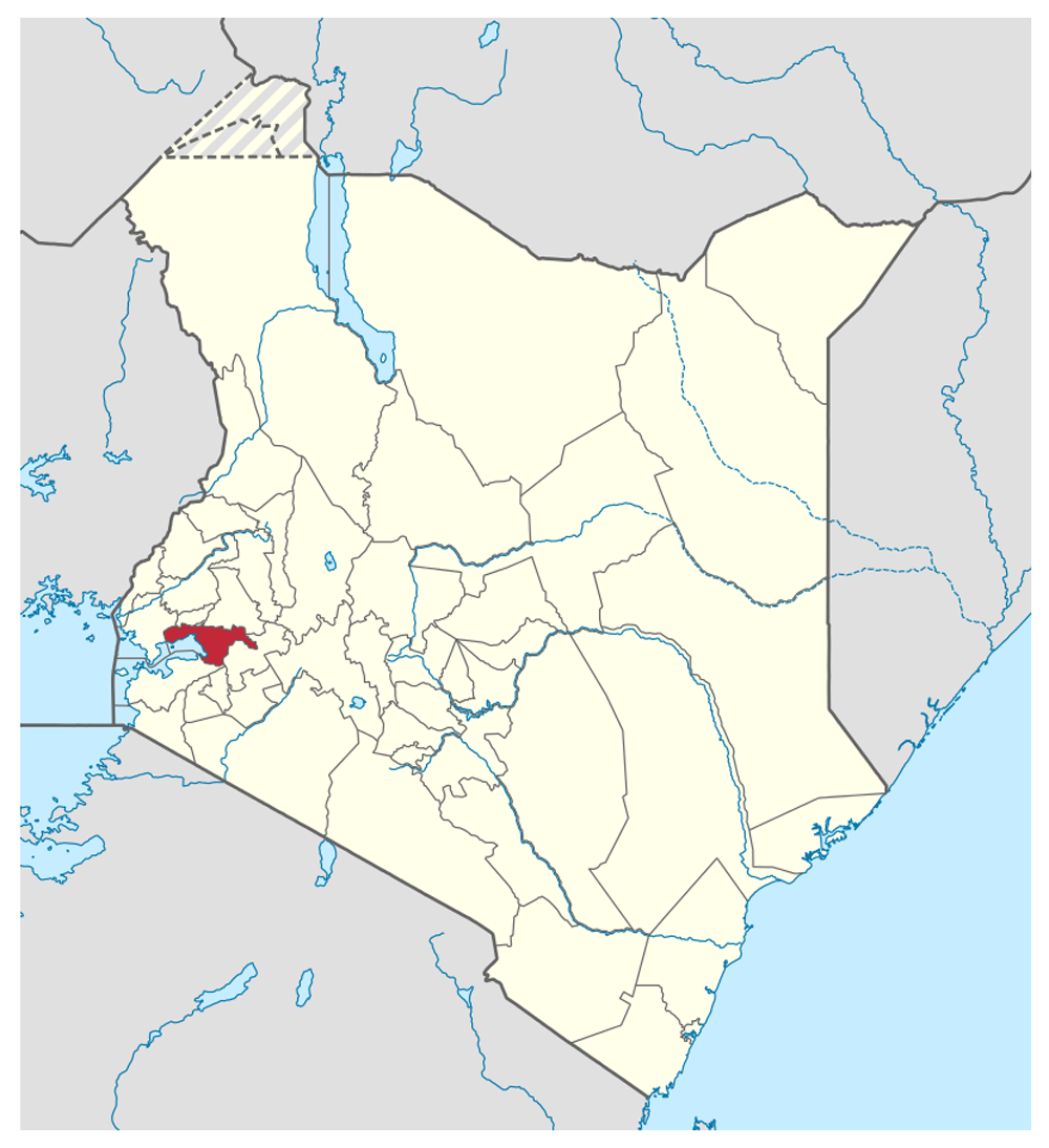
Kisumu County (Figure 1) is one of 47 counties in Kenya6. It lies within longitudes 33° 20’E and 35° 20’E and latitudes 0° 20’South and 0° 50’South. The total land area is approximately 2,086 Km2 and around 567 Km2 is covered by water. The County borders the expansive fresh water lake (Lake Victoria)7 and has 7 sub-counties namely; Kisumu Central, Kisumu East, Kisumu West, Seme, Nyando, Nyakach and Muhoroni. The sub-counties are further divided into administrative wards. The Kisumu West HIV program covers 6 wards namely North-west Kisumu, West Kisumu, Central Seme, East Seme, North Seme and West Seme.
This HIV care, treatment and prevention program in Seme Sub County and part of Kisumu West Sub County utilizes a “hub and spoke” model. Kombewa County Hospital, being the largest facility, is the “hub” wherein 24 peripheral health facilities (22 facilities in Seme Sub County and 2 facilities in Kisumu West Sub County) pivot for supply of commodities and drugs, training, viral load and HIV PCR sample processing.
A rapid results initiative (RRI) is a management tool that is used to mobilize teams to rapidly achieve tangible results8. During the Kisumu West HIV Program RRI of 1st June 2017 to 31st August 2017, HIV counselling and testing was conducted in the 24 health facilities of the Kisumu West HIV Program. The eligibility criteria of the present study included clients who had never tested for HIV, had tested negative in the past 3 to 12 months or had tested negative in the past 3 months or less but the negative result could not be verified by any available health record. Clients who declined consent to participate or clients whose guardians declined consent were excluded from the study.
Primary data on clients’ name, age, gender, residence and HIV status was entered into HIV Testing Services (HTS) registers and fed into an information management system, DATIM (Data for Accountability, Transparency and Impact). Data for this study was extracted from DATIM. HIV positivity was calculated as:
HIV positivity = (Number of clients testing HIV positive/Total Number of clients tested) × 100%
This HIV positivity was calculated for each testing health facility and aggregated at ward level wherein the health facility is located.
The data mined was entered into Microsoft Excel version 16.35 (RRID:SCR_016137) and then exported to STATA statistical software version 15 (RRID:SCR_012763) for processing and analysis.
The Kisumu County shapefile and geocodes of HIV positive, non-linked clients’ residences were exported to ArcGIS (ArcGIS for Desktop Basic, RRID:SCR_011081). An alternative open source GIS software for this spatial analysis is QGIS (RRID:SCR_018507). The locations of the clients’ residences, represented by the nearest known landmarks to their homes, were mapped on ArcGIS as points. These landmarks included features such as schools, churches, market centres etc. The geocodes of these landmarks were extracted from Google Maps (Version 2019 by Google Incorporated) by right clicking the “What’s here” Scalable Vector Graphic (SVG) marker and copy – pasting to Microsoft Excel.
The spatial patterning characteristics of HIV+ clients not linked to care was described using the Global Moran’s I statistic9. Global Moran's I statistic is a measure of spatial autocorrelation developed by Patrick Alfred Pierce Moran10.
In the Global Moran’s I statistic, spatial autocorrelation is characterized by a correlation of a point among nearby points in a given area and is given by:
where n is the total number of observations (points or polygons), i and j represent different locations, Xi and Xj are values of the variable in the ith and jth locations, is the mean of the variable and Wij is the weight in the spatial weight matrix. The clients’ age was used as the variable of interest because previous studies have demonstrated that younger age is a significant causative factor for non – linkage to care10. The spatial weighted matrix that was used was the inverse distance weighting function in ArcGIS. This is also available in QGIS.
Written informed consent for publication of clients’ details was obtained from the clients/parents/guardians of the clients as appropriate. The data was de-identified by the use of client numbers (not names). The geocodes of the clients’ residences were represented using their nearest landmarks such as nearby schools, churches and market centres. The exact geocodes of the clients’ residences were not used in this study in order to protect confidentiality.
Ethical and institutional approvals for this study were obtained from the Makerere University Research and Ethics Committee and the Kisumu County Department of Health.
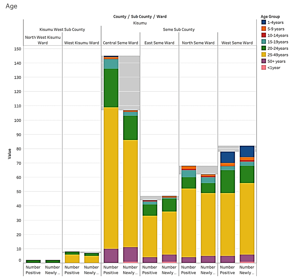
A total of 14, 077 clients were tested for HIV during the RRI period (men 38%, n=5,304; women 62%, n=8,773). Of the total clients tested for HIV, most (32%, n= 4,552) belonged to the 25–49 year age group, within which the majority were women (62%, n=2,811) (Figure 2).
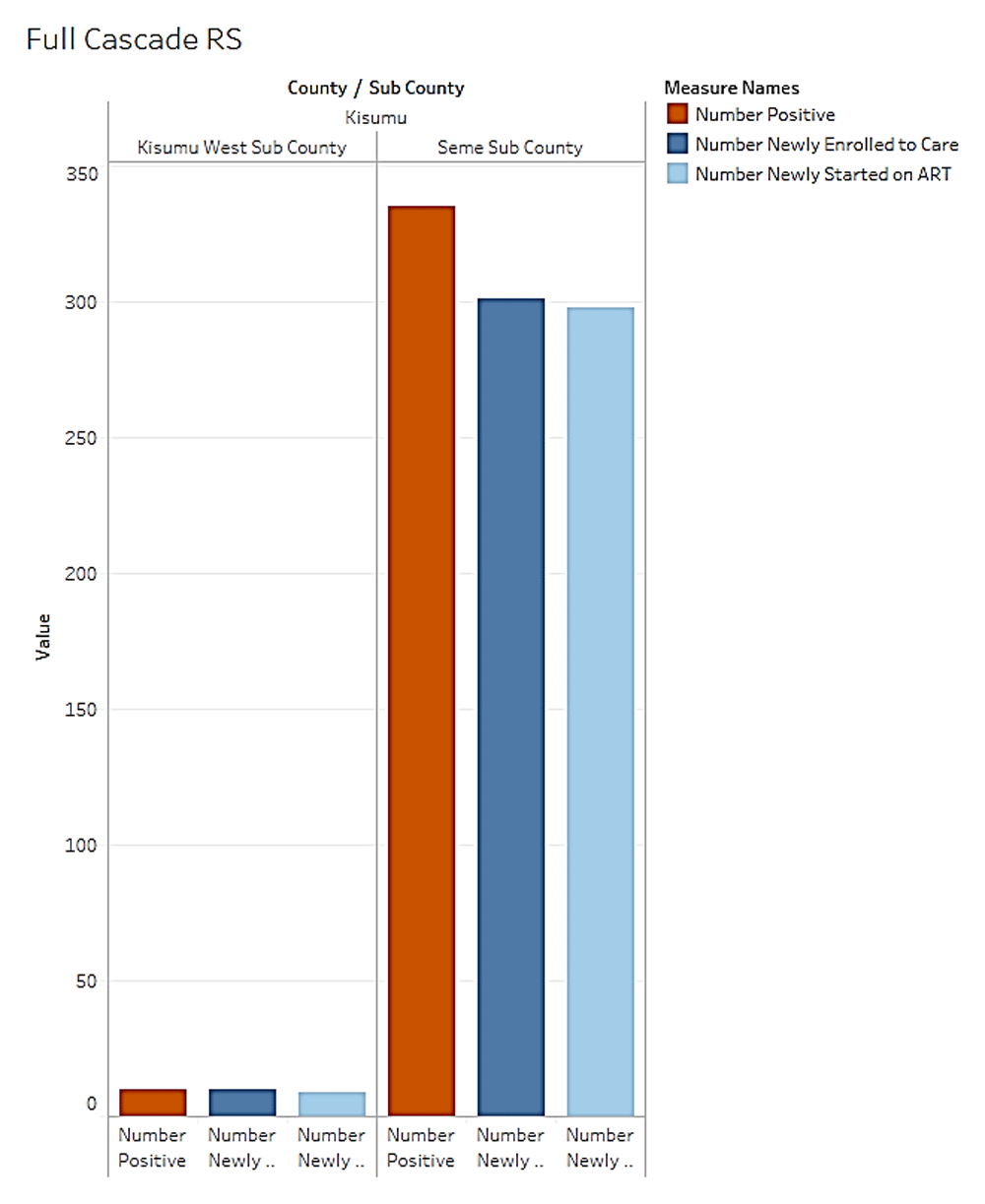
A total of 345 (2%) clients tested positive for HIV (range = 0–5%; mean = 1.5±1.6). Most clients that were HIV+ were in the 25–49 years age group (5%, n=226), of which more clients were men (52%, n=118; women, 48%, n=108). The <1 year old age group had the lowest number of HIV+ clients (0%, n=0). In the 1 – 4-year age band, West Seme Ward had the HIV highest positivity (89%, (n=8)) (Figure 3). The health facilities with the highest number of HIV+ clients were Kombewa (4.5%, tested n=2,505, HIV+ n= 112), Manyuanda (4.2%, tested n=970, HIV+ n=41), Bodi (3.9%, tested n= 431, HIV+ n = 17) and Oriang Alwala (3.6%, tested n=248, HIV+ n= 9).
Of all clients testing positive for HIV, 10% (n=34) were not yet linked to care two weeks after the diagnosis of HIV. Of these HIV+ non-linked clients, 50% were women (n=17), and most (65%, n= 32) had spatially identifiable data about their residences’ nearest landmarks.
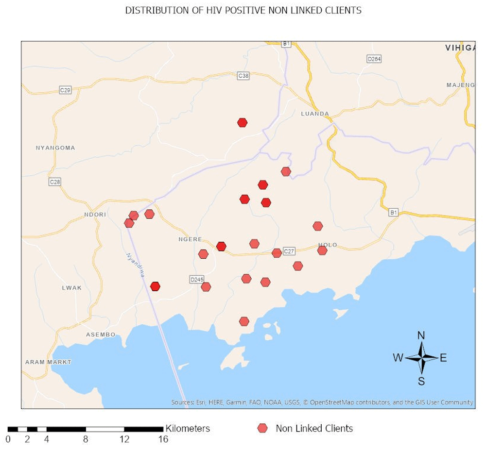
The geocodes of the clients’ residences’ nearest landmarks were obtained from Google Maps. The geocodes are as shown in Table 1.
The geocodes were used to map the distribution of HIV positive non-linked clients as shown in Figure 4.
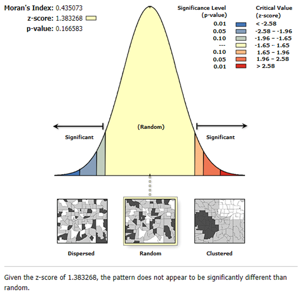
Regarding the spatial patterning characteristics of the clients who tested HIV positive but were not linked to care and with spatially identifiable residence information, the Global Moran I statistic for autocorrelation was 0.435 (z score 1.383, p- value 0.167) (Figure 5).
In this study, ArcGIS, a GIS software, was used to incorporate spatial attributes of clients’ residence to the HIV RRI data. This use of maps helped to better visualize the meaning of the numbers to provide more intuition about the distribution of HIV positivity and the spatial patterning of clients who tested HIV positive but were not linked to care two weeks after the diagnosis in the Kisumu West HIV program.
Having mapped the HIV positivity by different age groups and by different wards, it was established that most clients who were HIV+ were in the 25-49 year age groups (5%, n=226), which included more men (52%, n=118; women 48%, n=108). This shows that greater preventive efforts among this age group are required, and the establishment of targeted interventions for this cohort, such as viremia clinics, that seek to increase retention to care and viral suppression. Also, it was established that there was high positivity in children below 4 years in the West Seme Ward, which necessitates a need to audit the Prevention of Mother To Child HIV Transmission (PMTCT) programs in the health facilities in West Seme Ward in order to establish why there is a high number of HIV exposed infants seroconverting to active HIV infection. It was noted that while Oriang Alwala is a low volume health facility, it had the fourth highest HIV positivity rate (3.6%, tested=248, HIV positive n= 9); hence a need to redeploy more testers and adherence counsellors to this facility.
Regarding linkage, it was established that 10% of the clients who tested positive during the RRI period for HIV in the Kisumu West HIV program had not been enrolled into care. Through the use of GIS, it was possible to describe the spatial patterning characteristics of these non-linked clients via their residences’ nearest landmarks. The Global Moran’s I statistic for autocorrelation was 0.435 (z score 1.383, p- value 0.167) indicating that the pattern does not appear to be significantly different than random. This means that the distribution of the clients testing HIV positive and not getting linked to care, using age as an attribute value, does not follow the path of spatial clustering. Therefore, the most effective strategy for getting such clients linked to care is not to administer blanket community sensitization sessions on the need for linking into care following HIV positive results through community health education as is routinely done in the Kisumu West HIV program. Instead, through the use of distribution maps, linkage officers can generate a better work plan of navigating the program area as they conduct home visits to these clients.
In calculating the Global Moran’s Autocorrelation statistic, the clients’ age was used as the y attribute value. It would have been more accurate to use a composite score that quantifies the ‘level of severity of a client’s non linkage’. However, even after an extensive literature review, we could not find such a scale.
There are some concerns or issues with use of GIS tools for public health efforts. Chief among those is a concern for privacy and confidentiality of individuals11. It would be useful to collect more precise and accurate locator details, e.g. exact residence details, to allow for a more targeted approach towards getting these clients enrolled into care. However, this needs to be balanced with the need to protect clients’ confidentiality. There are certain strategies that can be employed to protect patient confidentiality. For example, data may need to be aggregated to cover larger areas such as a zip code or county, helping to mask individual identities during dissemination of results. Residential geocodes can as well be displaced. Also, maps can be constructed at smaller scales so that less detail is revealed11. In this study, we represented clients’ residences using the landmarks nearest to the residences in order to conceal the pinpoint location of the clients’ residence’s information.
Geographical information systems can be used identify spatial patterning characteristics of HIV positive clients that are not linked to care. A key requirement to achieving this would require the collection of precise and accurate spatially identifiable locator information. More research needs to be done on how geographical information systems can be used to describe the spatial patterning characteristics of HIV positive clients that are not linked to care without compromising patient confidentiality.
Figshare: HIV testing rapid results initiative 2017, https://doi.org/10.6084/m9.figshare.1224590612.
This project contains the following underlying data:
- 2017_RRI_ALL_Facilities.csv; used to calculate HIV positivity per facility
- HIV_Positivity.csv; used to calculate HIV positivity for different age bands
- Non_Linkage_To_HIV_Care.csv; used to calculate non-linkage to HIV care for different age bands
- Number_Newly_Enrolled_To_HIV_Care.csv; used to calculate non-linkage to HIV care for different age bands
- Number_Newly_Started_On_ART.csv; used to display number started on ART
- Number_Positive.csv; used to calculate HIV positivity for different age bands
- Number_Tested.csv; used to calculate HIV positivity for different age bands
- Residence_nearest_landmarks.csv; used for spatial analysis
Data are available under the terms of the Creative Commons Zero "No rights reserved" data waiver (CC0 1.0 Public domain dedication).
| Views | Downloads | |
|---|---|---|
| F1000Research | - | - |
|
PubMed Central
Data from PMC are received and updated monthly.
|
- | - |
Provide sufficient details of any financial or non-financial competing interests to enable users to assess whether your comments might lead a reasonable person to question your impartiality. Consider the following examples, but note that this is not an exhaustive list:
Sign up for content alerts and receive a weekly or monthly email with all newly published articles
Already registered? Sign in
The email address should be the one you originally registered with F1000.
You registered with F1000 via Google, so we cannot reset your password.
To sign in, please click here.
If you still need help with your Google account password, please click here.
You registered with F1000 via Facebook, so we cannot reset your password.
To sign in, please click here.
If you still need help with your Facebook account password, please click here.
If your email address is registered with us, we will email you instructions to reset your password.
If you think you should have received this email but it has not arrived, please check your spam filters and/or contact for further assistance.
Comments on this article Comments (0)