Keywords
Babeldaob, hillside farming, island, tillage, mulching, USLE equation
This article is included in the Agriculture, Food and Nutrition gateway.
Babeldaob, hillside farming, island, tillage, mulching, USLE equation
See the authors' detailed response to the review by Kebede Wolka
See the authors' detailed response to the review by Nor Rohaizah Jamil
See the authors' detailed response to the review by Kathleen B. Boomer
From the viewpoint of sustainability, annual soil erosion should be controlled below an erosion level of the T factor (USDA Natural Resources Conservation Service). Although No-tillage farming is effective for preventing soil erosion (Zuazo & Pleguezuelo, 2009) but the use of herbicides is unfavorable from an ecological perspective; therefore, reducing soil erosion in tillage farming is needed. The erosion caused by tillage occurs with small vegetation coverage in the early stage of the crop (Wischmeier & Smith, 1978). It is essential to increase the water infiltration rate at this stage. The water infiltration rate is positively proportional to the root mass of the crop soil (Oda et al., 2019). Therefore, we tried clarifying the risk of erosion and the effect of root mass for preventing soil erosion in a field with an incline typical for Palau in an area categorized as highly erodible. Surprisingly, there was no erosion at all in all plots. The results show that land at low risk of soil erosion can be found by determining site-specific K factor measurements. Although the effects of the treatments were not observed, this information is important for Palau’s agricultural development.
Palau forms part of the Micronesia region in the western Pacific Ocean. Palau's economy is mainly due to tourism and the increase in tourists increases the consumption of agricultural products. Palau imports them, but it is preferable to produce them domestically. The agriculture in Palau is mainly taro cultivation at swamp by a traditional and environmentally friendly method. Before World War II, Japanese settlers developed agricultural land. In recent years, the redevelopment of these fields using modern farming methods has begun. Fields with inclines of more than 8° are unsuitable for growing crops, but most of the agricultural fields in Palau have slopes of more than 8°. The island is also subject to heavy rainfall (ca. 3300 mm – 3900 mm). USDA Natural Resources Conservation Service in 2009 categorized most of the land (80%) as the most fragile rank (T factor = 1). T Factor values range from 1 ton/acre/year for the most fragile soils, to 5 tons/acre/year for soils that can sustain more erosion without losing significant productive potential (USDA Natural Resources Conservation Service). A study estimated the risk of soil erosion from agricultural land was reported to be from 720 to 813 tons per ha per year (Gavenda et al., 2005).
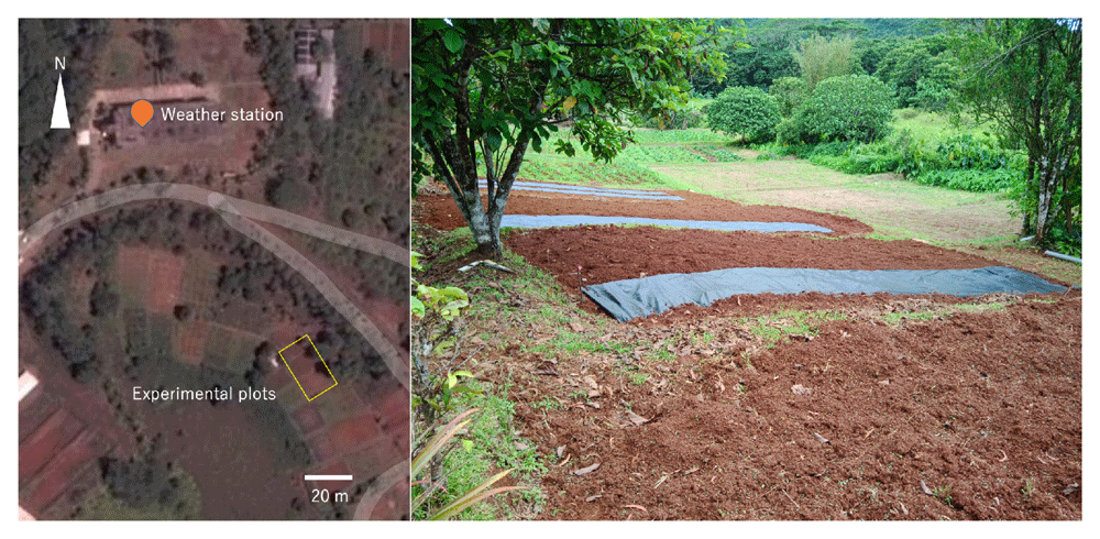
The experiment was conducted at the Palau Community College Research and Development Station (N7.529694, E134.560522). The station is located in the interior of Babeldaob Island, the second largest of the Micronesian islands, and is surrounded by forest. The field is one of the agricultural fields that were once used by the Japanese settlers. The soil here is Oxisol (ferralsols)—“Ngardmau-Bablethuap Complex,” which is characterized as a very gravelly loam with low organic matter content of between 1% and 4%. The permeability is moderately rapid (15–50 cm/hr) and very well drained. The available water capacity is between 0.05 and 0.10 cm/cm (Smith, 1983).
The experiment was conducted from January to July 2019. The slope is 15.4° (13.4°–17.3°). The previous crop grown on the land was taro (Colocasia esculenta). The treatments were plants (with or without) × ridge (with or without) × 2 replications. These eight plots (2 × 10 m) were randomly set on the field (Table 1, Figure 1). The field was tilled using a hand tractor on January 22, leveled, and covered half the plots with weed control fabric (polypropylene, 0.4-mm thick, 120 g m–2; I-Agri Corp., Tsuchiura) on 28 January. Weeds were cut on April 16, blown off the residue, removed the weed control fabric on April 17 (Figure 2), then tilled each plot using the hand tractor up and down direction to avoid the soil moving to neighboring plots. The average thickness of the soil tilled was 16 cm. A 70 cm width of the monitoring areas was made in the center of the plots by ridges or wooden boards (for the no-ridge treatment). Sweet potatoes (Ipomoea batatas) were transplanted at 70 cm intervals on April 17 (Figure 3). Trenches were dug at the upper end of the fields to prevent rainwater inflow. The lower ends were embanked and added 1-m lengths of weed control fabric to trap any eroded soil. Fertilizer was not applied. Hand weeding was conducted on May 21 and June 6.
| Block | Plot ID | Plants | Ridge | Slope/° |
|---|---|---|---|---|
| Left | 4 | 15.1 | ||
| 7 | + | 17.3 | ||
| Mid | 1 | + | 14.2 | |
| 5 | + | + | 14.6 | |
| 6 | + | + | 15.7 | |
| Right | 8 | + | 13.4 | |
| 2 | + | 16.1 | ||
| 3 | 16.6 |

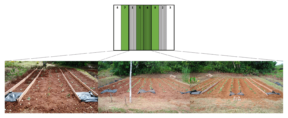
Green: No mulch treatment, Stripe: Ridge treatment.
Weed control fabric was set up at the lower end of the ridge and fixed them to the ground with several wire bents into a U-shape (Figure 3). At the bottom of the rows, The soil was raised to a height of about 20 cm to create a weir to prevent the soil from flowing out. Precipitation data were collected every 5 min via a weather station in the Palau Community College Research and Development Station (about 100 m from the experimental fields; Figure 1). The condition of the fields was recorded using an automatic camera.
Rainfall events that might cause severe erosion (more than 3 mm/10 min) were identified (Onaga, 1969) and the amount of eroded soil of each event was compared.
The amount of eroded soil was predicted with the Universal Soil Loss Equation (USLE) equation (Wischmeier & Smith, 1978) by the following formula using Microsoft Excel (Changed the original formula to meters).
A = R K LS P C metric ton ha–1 year–1
Where A = computed soil loss per unit area, R = the rainfall and runoff factor, K = the soil erodibility factor, LS = the topographic factor, C = the cover and management factor, and P = the support practice factor.
Storm soil losses from cultivated fields are directly proportional to a rainstorm parameter defined as the EI, and the A of each storm can be obtained using EI instead of the R.
E = 210+89 log10 I 100 metric ton ha–1
I cm h–1: maximum rainfall in 30 min multiplied to 60 min; rainfall less than 1.27 cm is omitted, and the maximum value is 7.62 cm.
Soil erosion in a rainfall event is the cumulative value.
R = EI/100 metric ton ha–1
For the United States of America, for convenience, the average annual rainfall intensity for the region is prepared as a table. In the case of Palau, the frequency of rainfall is extremely high, so the integrated values during this test period are considered to be sufficiently accurate.
Finally, the above equation was parameterized for each rainfall event as follows.
A = EI K LS P C/100 metric ton ha–1
K = 0.05 (USDA Natural Resources Conservation Service; estimated based on percentage of silt, sand, and organic matter and on soil structure and permeability)
LS = (10/20.0)^0.5・(68.19 sin2 15.4° + 4.75sin 15.4°+0.068)= 4.34
C =1.0; Tillage
P = 1.00; vertical ridge
Plot area = 7 m2
When the survey area is less than 10 m2, the erosion rate is almost constant, but when the survey area exceeds 10 m2, the erosion rate decreases linearly as the area increased (García-Ruiz et al., 2015). Accordingly, this experiment may overestimate soil erosion.
The field site received regular rainfall, with total precipitation of 992 mm during the experimental period, from 17 April to July 15 (Figure 4). The field had 24 days of erosive rainfall more than 3 mm per 10 min (Figure 4). The rainfall threshold where surface runoff occurs is 2–3 mm per 10 min on a 15° slope, although these values vary according to different soil characteristics (Onaga, 1969). Highly erosive rainfall events occurred on day 7 after planting (May 2). After weeding is an erosive period. A heavy rainfall event of 17 mm per 10 min occurred on the next day after the first weeding. The second weeding was conducted after seven days of intensive rainfall, and a further erosive rainfall event of 7 mm per 10 min occurred after weeding. Thus, the rainfall conditions during the experimental period were expected to result in severe soil erosion.
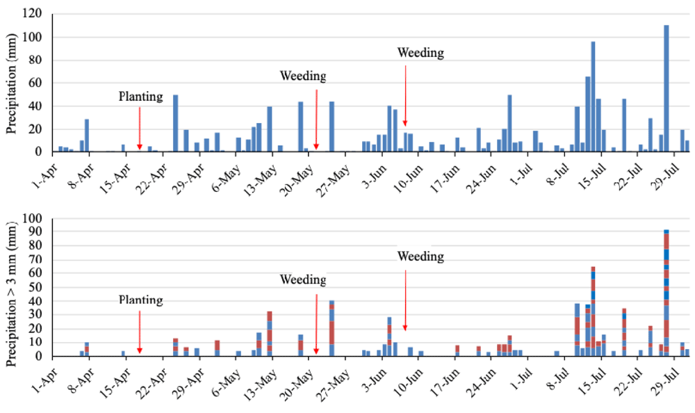
The blocks show a rainfall event of more than 3 mm/10 min and the amount of precipitation. The colors distinguish the events.
The 24 rainfall events potentially caused erosion during the observation period (Table 2). The soil loss prediction for bare land conditions by USLE was 0.57 kg per plot on day 7 (the first rainfall event after transplanting) and 2.82 kg (after the first weeding).
I cm h–1: maximum rainfall in 30 min multiplied to 60 min; rainfall less than 1.27 cm is omitted, and the maximum value is 7.62 cm (Wischmeier & Smith, 1978).
Despite the severe rainfall conditions, none of the plots had any erosion at all through the experimental period (Figure 5).
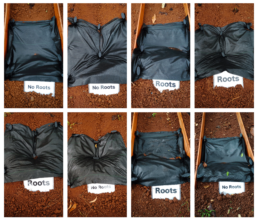
The predicted erosion was 0.57 kg per plot; however, the actual erosion was 0 kg in all plots.
Most of the soil surface was bare by day 14 (May 1). Small weeds covered the soil surface by on day 21 (May 8), the day of the first weeding. The vegetation coverage by visual inspection ranged from 15%–85% on day 54 (Jun 10), after the second weeding. The vegetation coverage was 100% by day 89 (July15) (Figure 6).
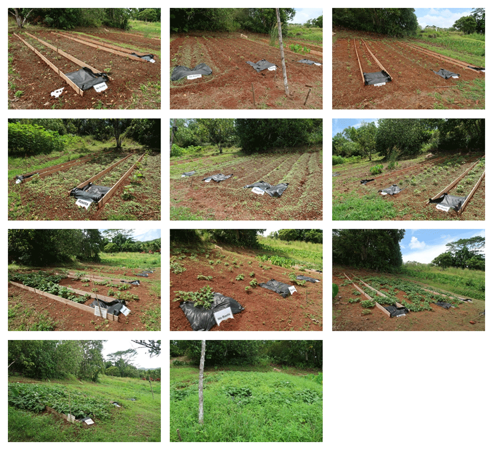
Top panel: day 14, Upper middle panel: day 21 (before the first weeding), Lower middle panel: day 54 (after second weeding), Bottom panel day 89.
We conducted an experiment to evaluate the effect of root mass on erosion reduction under tillage conditions. The experiment was conducted under erosion-promoting conditions: a slope of about 15°, vertical ridges, and prior placement of weed control fabric (which is expected to erase the effect of root mass in preventing soil erosion). Many intense rainfall events occurred during the experimental period, and 32 metric ton ha–1 of soil erosion was predicted. Nevertheless, no soil erosion occurred. Those fields have high soil erosion tolerance and tillable. The use of mulching material expected to erase the effect of root mass of weeds for preventing soil erosion; however, our results show still the use of mulching material is available. Interestingly, soil erosion occurred in another trial conducted in an adjacent plot. They used horizontal rows. We assumed the erosion caused by catch canals. Catch canals of the horizontal ride are highly erosive (Shima et al., 1991) but vertical ridge has no catch canals.
Precipitation of 992 mm during the three months of the experimental period was large and they included 24 days of erosive rainfalls. The conditions were comparable enough to the average annual conditions of the US; therefore, the conditions were appropriate to apply the USLE equation. What is the reason for the no erosion under the condition of the large prediction and the measured eroded soil? For the parameters of the USLE equation in this study, only the K factor was not measured (cited from a USDA report). Namely, the K factor was larger than the actual value.
The estimates of K factors are based primarily on percentage of silt, sand, and organic matter and on soil structure and permeability (USDA Natural Resources Conservation Service in 2009). Many calculation methods have been proposed for K factor such as Revised Universal Soil Loss Equation (RUSLE2), Erosion Productivity Impact Calculator (EPIC), and Geometric Mean Diameter based (Dg) model; however, the versatility of USLE for some soils are higher than that of the new method (Wang et al., 2016). Thus, there is a large room to find suitable land for agriculture from the area of specified unsuitable for agriculture. Not erosion itself, but a related story, the use of USLE to predict sediment yields is not advisable despite their present widespread application (Boomer et al., 2008).
Low erosion land for agriculture can be found by measuring erosion locally. The results obtained from a limited field, still, are important for Palau's agricultural development, and the results of this test can be regarded as reference.
Figshare: Precipitation of Palau, https://doi.org/10.6084/m9.figshare.11769909.v1 (Oda et al., 2020).
This project contains the following underlying data:
Data are available under the terms of the Creative Commons Zero "No rights reserved" data waiver (CC0 1.0 Public domain dedication).
| Views | Downloads | |
|---|---|---|
| F1000Research | - | - |
|
PubMed Central
Data from PMC are received and updated monthly.
|
- | - |
Provide sufficient details of any financial or non-financial competing interests to enable users to assess whether your comments might lead a reasonable person to question your impartiality. Consider the following examples, but note that this is not an exhaustive list:
Sign up for content alerts and receive a weekly or monthly email with all newly published articles
Already registered? Sign in
The email address should be the one you originally registered with F1000.
You registered with F1000 via Google, so we cannot reset your password.
To sign in, please click here.
If you still need help with your Google account password, please click here.
You registered with F1000 via Facebook, so we cannot reset your password.
To sign in, please click here.
If you still need help with your Facebook account password, please click here.
If your email address is registered with us, we will email you instructions to reset your password.
If you think you should have received this email but it has not arrived, please check your spam filters and/or contact for further assistance.
Comments on this article Comments (0)