Keywords
GIS, Landscape Analysis, Sweden, Historic Environment Record, data restructuring, python, regular expressions
This article is included in the New Digital Archaeologies collection.
This article is included in the Python collection.
GIS, Landscape Analysis, Sweden, Historic Environment Record, data restructuring, python, regular expressions
A more detailed description of how the software works has been added to the Methods section, and an outlook of the the more general take-away from this very specific case study at the end. The title of the paper has been changed to better represent that this is a tool that solves a specific task with a specific dataset.
See the authors' detailed response to the review by Francesco Carrer
See the authors' detailed response to the review by Daniella Vos
Many fields of archaeological research are revitalised as digital technology enables the use of large volumes of data for analysis (Huggett 2020). Increased access to information from the internet and online databases enables both completely new approaches to interpret prehistory, and also makes it possible to revisit previous results with new computational methodologies to verify or challenge previous theories (Cooper & Green 2016, Gillings, Hacıgüzeller & Lock 2022). However, access to data is not enough, and it is often necessary to apply some data wrangling techniques to ensure that data structures are appropriate for analysis. Especially reusing data from external sources, that may have been collected for other purposes, often means that the data will need more or less extensive preparation before analysis (Gupta 2020). Sweden has good access to geodata about archaeological sites since the Swedish National Heritage Board (NHB, Swedish: Riksantikvarieämbetet, RAÄ) has provided a digital record of sites as open access since 2006 when the Archaeological Sites and Monuments Information System (FMIS) were launched (Larsson & Löwenborg 2020). In 2018 this was replaced by the updated new Historic Environment Record (HER, Swedish: Kulturmiljöregistret KMR), which in addition to protected sites also has information about archaeological investigations, reports and to some extent also documentation (Larsson, Smith, Sohlenius & Klafver 2017). HER currently holds about 800 000 sites, with different levels of legal protection. Since the purpose of this database was to record the antiquarian status of each site, the data structure was not primarily designed to facilitate analysis (Löwenborg 2007, Sohlenius 2014). However, the information in the record still holds much data that will be of interest for research purposes, to understand regional differences through spatial analysis and approaches from landscape archaeology.
One aspect that makes it more difficult to work with the data is that several sites are composites that contain information about individual features that are part of a larger site. Typically, a burial ground has information about how many graves have been observed during the survey and the classification of their external features. This is described as “grave type”, “shape” and “construction details”, as defined in the Lämningstyplista. Some graves have two variables for construction, to describe different aspects, and there are also a few occurrences of a variable type “fyllning” that only has one value: “Rödockrafärgad sand” i.e. a grave that contains red ochre sand. Thus, to describe a grave there can be up to four values plus the number of graves of each type. The most common grave type, the mode value, is “stone settings” (stensättning) with shape “round” (rund) and construction “earth filled” (övertorvad), as seen in Table 1 below. These represent almost 50% of all graves in HER. In this paper, we will present a new open source python program that uses regular expressions to restructure Swedish HER data to a format that is more suitable for statistical analysis. While the program is specifically designed for this particular dataset, the principles for restructuring data would be relevant in other cases where a compact data structure, suitable for easy dissemination of data online, needs to be reorganised for analysis. This will be illustrated with an example of extracting all the graves in Sweden and looking at some patterns in this material. We will also present a use case of how to prepare the data to facilitate analysis.
The former FMIS system had a different solution for how information about grave features were included in the data compared to the new HER record. In FMIS, information about individual features (graves) that are part of a composite site (burial ground) was in a separate table, called “nil”, that was included with the exported shapefiles. The nil table had an identification key (samsatt_id) that related to the geometries in the shapefile so that information about the individual graves could be related to the sites. The information about features was divided into separate rows and fields, which together provided information about the number of different graves at a burial ground. Since the information was split up into different fields and rows, it was necessary to rebuild the data in the record in order to perform statistical analysis. This could be done in different ways with different software tools (Löwenborg 2007, Ma 2020). With the transition to the HER system, a different solution for presenting the data was used, which make use of the new data format for geodata; GeoPackage (GPKG) developed by the Open Geospatial Consortium. One of the benefits of the GPKG format is the possibility to include long string values in the attribute table. Rather than keeping the information about individual features in a separate table, and in multiple rows and fields, the HER format makes an array of all this information, and includes that in a field in the GPKG dataset. Information about the transition from FMIS to HER, the quality work involved in this, and some information about how data was restructured are described on the NHB website. The new variable with information about features at a site is called “ing_lamn” (Swe: ingående lämningar) and would look like this for the mode grave type described above:
{"lamningstyp":"Stensättning","antal":X,"egenskap":"Konstruktion:Övertorvad, Form: Rund"}‘X’ here is the number of this particular type of graves at a site. Since a burial ground often has graves of different types and kinds, each type will be represented by a similar string, and burial grounds could thus have a string of considerable length to describe all the types of graves there. An example from HER, L2014:3046, with one of the larger and more complex sites with many different grave types looks like this:
[{"lamningstyp":"Boplats","antal":1,"egenskap":null},{"lamningstyp":"Grav - uppgift om typ saknas","antal":3,"egenskap":null},{"lamningstyp":"Grav markerad av sten/block","antal":300,"egenskap":"Typ:Rest sten"},{"lamningstyp":"Stenkrets/stenrad","antal":1,"egenskap":"Form:Övrig"},{"lamningstyp":"Stensättning","antal":1,"egenskap":"Konstruktion:Övertorvad, Form:Skeppsformig"},{"lamningstyp":"Stensättning","antal":254,"egenskap":"Konstruktion:Övertorvad, Form:Rund"},{"lamningstyp":"Stensättning","antal":30,"egenskap":"Konstruktion:Stenfylld, Form:Rund"},{"lamningstyp":"Röse","antal":1,"egenskap":"Form:Rund"},{"lamningstyp":"Hög","antal":1,"egenskap":"Form:Rund"},{"lamningstyp":"Stensättning","antal":6,"egenskap":"Konstruktion:Övertorvad, Form:Kvadratisk"},{"lamningstyp":"Stensättning","antal":4,"egenskap":"Konstruktion:Övertorvad, Form:Rektangulär"},{"lamningstyp":"Stensättning","antal":8,"egenskap":"Konstruktion:Övertorvad, Form:Triangulär"},{"lamningstyp":"Stenkrets/stenrad","antal":15,"egenskap":"Konstruktion:Övrig, Form:Domarring"},{"lamningstyp":"Stenkrets/stenrad","antal":34,"egenskap":"Form:Kvadratisk"},{"lamningstyp":"Stenkrets/stenrad","antal":4,"egenskap":"Form:Rektangulär"}]For graves registered as individual, single graves, the structure is different. These would generally be solitary graves, or in sparse groups, where each grave is recorded as a unique object in the register. These are usually a point but could also have a polygon geometry. For these objects, the information about grave type is in the variable “lamningtyp” (i.e. stensättning) and information about shape and construction details of these, if any, are recorded in the variable “egenskap” (i.e. Form: Rund, Konstruktion: Stenfylld). If no features are used to describe the grave, the “egenskap” variable will be ‘NULL’. There is no number associated with these objects since they all represent one single grave.
Having all information about burial types collected in one file is a great benefit compared to the previous version with the “nil” layer. The nature of the information where the data is split up into different variables for individual graves, and the complex structure of the “ing_lamn” string, still means that it cannot be analysed statistically without prior remodelling. A fairly simple question as to how many burials there are at a burial ground site means that all the “antal” (number) values would need to be summed up for each site. More complex queries, such as how many stone settings, mounds or other types of graves there are, mean that the “antal” needs to be summed separately. To also account for the different shapes and construction types makes it quite complex to extract the information for anything more than a few individual sites. In order to calculate this for regions, or even at a national level, it will first be necessary to restructure the data completely. The program Inglämnlagare, written by Filipp Antomonov, does this by extracting all different categories of burial types and adding the number of these into separate fields for each type.
In order for Inglämnlagare (Löwenborg 2022b) to work correctly, the data has to be supplied in a comma-separated value file and include a fid attribute to each object in the database, needed for sorting the data. The program, provided as a single script file Ing.py, is written in Python programming language (RRID:SCR_008394) and has multicore support in order to improve processing performance of large files. The script can be run in any Python environment (including directly in QGIS) or compiled as a standalone executable for Linux, Windows or Macintosh operating systems to be used without an installed Python environment. A general outline of the process of extracting information from HER data using Inglämnlagare is described in the use case below.
To get the most out of the program Inglämnlagare there are several steps needed both before and after, to ensure reliable results that are suited for further analysis. Here we will present a short use case of the steps involved, working with all graves from HER Lämningar, and extracting a subset for analysis. For preparation of data beforehand, and for analysing the results, we will use the Open-Source GIS (Geographical Information System) program QGIS (RRID:SCR_018507) version 3.22.11. The HER Lämningar is available as open data from the Swedish NHB at their open data portal. To have all the data, it is the GPKG version that should be used, since the Shapefile version is missing the ing_lamn variable. In the version that was used here, downloaded on August 16, 2022, there are 799,272 objects available, divided into 507,188 point features, 77,242 lines and 214,842 polygons. For regional analysis where the individual geometries are not needed, it is recommended to first convert all features to points (centroids) and merge them to one layer so that all analysis can be done on the same dataset. Converting to points might create duplicates from multipart features, which should be removed before analysis.
Depending on the questions at hand, it will usually be relevant to make a selection of the data in order to limit the number of objects before continuing. In this example we are only interested in actual archaeological sites. The register holds other categories too in the variable “antikv_bed”, describing the legal status of each site. In this case, we want ‘Fornlämning’ (ancient remains) and ‘Ingen antikvarisk bedömning’ that includes sites that have been excavated and removed, thus losing their legal protection as ancient sites. We might want to include ‘Möjlig fornlämning’ (possible ancient site) but the remaining categories would not be relevant in this case (see the NHB website for information about the classification of sites).
The key variable for selecting relevant sites is “lamningtyp” as this holds information about the general category of each site. Full descriptions of these categories are in Lämningstyplistan, available from NHB. This list holds both the formal definition of each category, and also explains how graves can be either as simple categories, where each object is one type of grave, or be part of composite sites, where graves can be included in either burial grounds (Gravfält) or burial and settlement sites (Grav- och boplatsområde). For this example, graves that would not be prehistoric were excluded. The following query was used in QGIS to select all categories of sites in the HER database that would contain graves according to the criteria above:
"lamningtyp" = 'Grav - uppgift om typ saknas' OR "lamningtyp" = 'Grav markerad av sten/block' OR "lamningtyp" = 'Grav övrig' OR "lamningtyp" = 'Gravklot' OR "lamningtyp" = 'Grav- och boplatsområde' OR "lamningtyp" = 'Gravfält' OR "lamningtyp" = 'Hög' OR "lamningtyp" = 'Järnåldersdös' OR "lamningtyp" = 'Stenkammargrav' OR "lamningtyp" = 'Stenkistgrav' OR "lamningtyp" = 'Röse' OR "lamningtyp" = 'Stenkrets/stenrad' OR "lamningtyp" = 'Stensättning'
This query returned 127,641 objects. Before proceeding, it might be practical to delete fields with data not needed later, such as antiquarian and meta information about data creation. If working with a large selection of sites, it might also be advisable to write XY coordinates to each site in the attribute table. This can simplify the process of bringing the data back into GIS software after analysis, by adding points based on coordinates. Another option would be to join the output of the analysis to the original point layer, but that can be difficult with large volumes of data. Following this, the data can be exported to a CSV file and parsed by the program.
As an example, below, Inglämnlagare is executed in QGIS under Windows, via the built-in Python console, located in the Plugins menu. Start by defining the variable ing, by entering the path to the script file Ing.py:
ing = r"C:\GIS\Ing.py"
After replacing the path above with a correct one for the script’s location on the machine, the process is then initiated by entering the following string in the console, as illustrated in Figure 1:
import subprocess; subprocess.run("cmd/c python \"" + ing + "\"")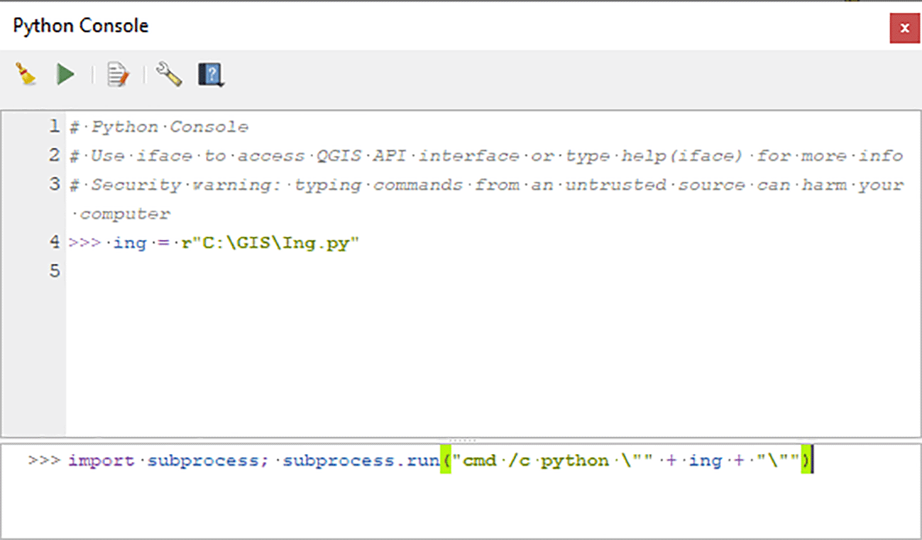
However, if the machine, regardless of the operating system, already has an installed Python environment, Inglämnlagare can simply be started in the shell via the command python Ing.py. And in the case of a compiled executable, just by running it. The program begins by asking for an existing input file and a desired output file. If only a filename is entered for the input, the location is assumed to be the one of the program file; in case of the same for the output – that of the input file.
Internally, Inglämnlagare is divided into four methods and utilizes parallel computations, taking advantage of multiple CPU cores. The main function of the program, handling user interface for file input, activates the second and third method in parallel in order to increase the efficiency of data processing. The second method handles output file user interface, with the third normalizing input data and creating a dictionary data structure of all possible combinations of site types and attributes – lamningtyp/egenskap values. The fourth and last method is used for counting the number of features, corresponding to the unique combinations found throughout input data, and writing the new individual fields to a comma-separated value file. It shall be noted that input files are never loaded into random access memory of the computer at once, always being read line by line. This has the advantage of being able to handle input files of vastly different sizes, at the same time being hardware-agnostic: the processing may take longer on a slower machine, but will not cause memory overflow errors. Inglämnlagare has been successfully used for input files of a couple of kilobytes in size, as well with gigabyte-scope data massives.
To identify relevant segments of information within the strings, regular expressions are used throughout the program. Regular expressions are a set of powerful functions within computational linguistics for working with patterns in text, to manipulate or extract information. For example, the command \d+ finds one or more numerical values – from the string below, the value “6” would be returned:
{"lamningstyp":"Stensättning","antal":6,"egenskap":"Konstruktion:Övertorvad, Form:Rund"} The same principle is used to identify grave type, shape and construction detail, using the structure of the “ing_lamn” variable. When all possible types of graves have been identified, these are added as new fields, so that the example above would be a new variable called: “Stensättning – Konstruktion: Övertorvad; Form: Rund”. For each row in the file, the number of features (“antal”) is then extracted and written as a value for the object, identified by the fid. For the single graves where no number is provided, the value is set to “1”.
The output of Inglämnlagare is written to a new CSV, with all the input values intact, and with the addition of fields for all possible combinations of values. This can be a very long list, depending on what selection of sites was used as input, and the complexity of these in terms of possible values. Extracting all the graves contained in the HER database gives a total of 507,078 individual graves from 127 641 sites. The graves are classified into 135 different grave types. Stone settings are both the most common type of grave, and are also represented by the most variables for different combinations, with 53 different types in total.
Many graves are of the same type. The top five categories hold 83,5 % of all the graves, and the most common types are presented in Table 1. At the other end of the scale, there are 14 types of graves that are represented by only one object each, such as one: Stensättning – Konstruktion: Övertorvad; Fyllning: Rödockrafärgad sand; Form: Oval. Some of the less frequent types of graves might be interesting to explore closer as they could represent specific burial practices that can inform us of cultural and social prehistoric phenomena.
For further spatial analysis the data can be imported back into QGIS, and for an efficient workflow there are a few suggested steps to prepare the data still. Including more general composite categories, such as 'Grav- och boplatsområde' as in the example query provided above, means that when all objects in “ing_lamn” will be written as a new variable in a field, the number of fields might become very large, and will probably contain information that is not needed. In this case, the resulting table holds 356 fields, where a large number are features from settlements, such as hearths, post-holes, houses etc. Deleting unwanted fields from a table might be difficult, especially in GIS software, so a faster approach might be to export the result to a new layer, and only include the desired fields in the export. This can be achieved during the setup of the export to a new GPKG, by excluding all fields except those that should be kept for further analysis, making the data more manageable. When all fields that contained non-grave information had been removed, only the 135 variables with fields containing graves remain. As this still is a fairly large number of variables, that might contain more information than needed for the analysis, a useful technique would be to combine the categories of interest into a new field. For example, we might only be interested in graves of a particular shape, but not all the different descriptions of construction of these.
One example of grave type that might be out of interest for further analysis are rectangular stone settings, which often have been associated with the early phases of Christianity at the end of the Viking period (Therus 2019, 42). If we would single out stone settings of rectangular shape, we would still be left with five categories, depending on the construction types. It might further be of benefit to combine these with other grave types, such as rectangular graves constructed with erected stones. These antiquarian classifications may or may not be relevant to the archaeological questions we have, so it is up to the research questions to define analytical units. Assuming we would like to explore rectangular graves, it might be relevant to include both kinds of rectangular graves for a total of 8,004 individual graves, distributed on 3,578 different sites, listed in Table 2.
The differences in the construction types are “boulder stones”, “erected stones”, “supported stones”, “no fill”, “stone filled”, “earth-filled”, “other” or without value.
Unless analysis will be made of all the characteristics of the nine different fields containing information about rectangular stone settings and rectangular graves of erected stones, further analysis would be more efficient if all the rectangular graves are added up to a single new field, that has the sum of all graves of this type. A useful function for doing this is the possibility to filter variables by parts of field names in the QGIS Field Calculator as illustrated in the central section of Figure 2.
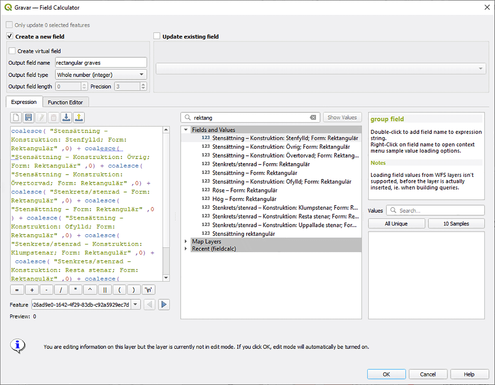
This simplifies the identification of fields that should be included for extracting the values to the new field “rectangular graves”. Note that rectangular mounds and cairns were not included here, as they are more likely to represent a different cultural expression. Screenshot from the program QGIS version 3.22.11.
Depending on what software is used for further analysis, it is also important to be aware of how NULL values are handled. Adding up fields that include any NULL in QGIS values would give a NULL output for the total. To avoid this, NULL values could be changed to ‘0’, or as in the example in Figure 2, the SQL expression COALESCE could be used, in order to regard NULL values as 0 for the calculation and add up any real numbers. Summed values such as the new field “Rectangular graves” would make further aggregation into areal units fast and efficient.
For a small number of sites, it might well be enough to plot them on a map to see the distribution, as in Figure 3. The version of rectangular graves that have been classified as erected stones are only present in the southern part of Sweden, with a few concentrations for example around the island of Öland.
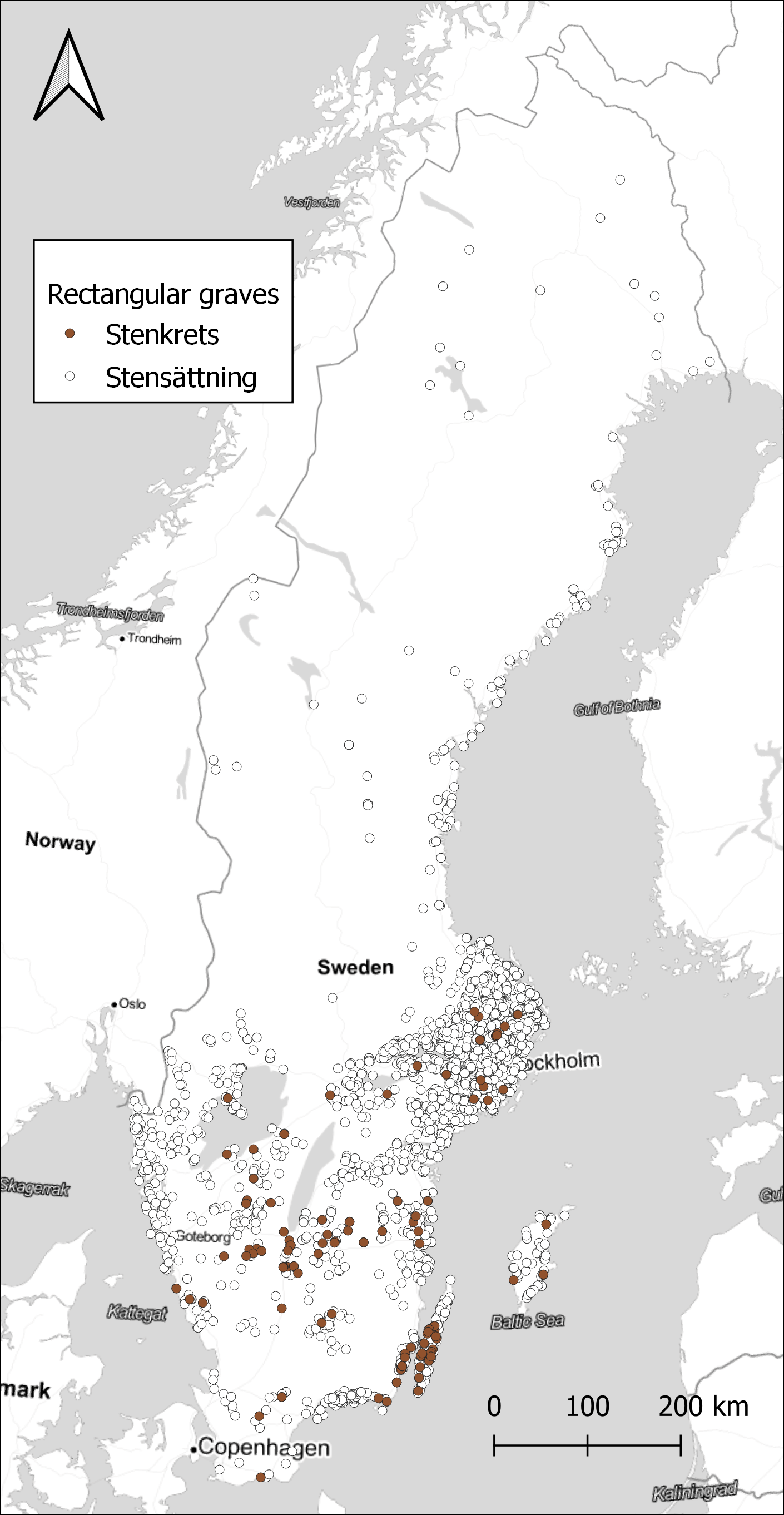
Data from NHB/RAÄ Kulturmiljöregister (KMR), 2022-08-16. Map tiles by Stamen Design, under CC BY 3.0. Data by OpenStreetMap, under ODbL.
With a larger number of sites, it is better to aggregate the results to visualise spatial differences. Here, the choice was made to use watersheds as the unit of spatial aggregation. Watersheds have been suggested as a geographical unit that might have relevance in this area during the Late Iron Age, as a possible natural background to the early medieval hundred district organisation (Löwenborg 2008). Looking at how the rectangular graves are distributed on the watersheds, there is a concentration in the central parts around Lake Mälaren and on Öland, as seen in Figure 4. However, looking at the ratio of rectangular graves compared to the total number of graves within each watershed displays a different pattern, in Figure 5. A few small areas on the coast in Uppland and Blekinge show high concentrations, and also some areas in the far north. Comparing with Figure 3, we can assume that rectangular graves primarily are a coastal phenomenon also in the north, with a few exceptions in the inland. While the substantial differences in the size of the watersheds might be obscuring some relevant patterns, it illustrates the potential in exploring the data in different ways. With the large amount of data that restructuring the original dataset of sites provides, there are great opportunities to explore different patterns that otherwise would be difficult to observe.
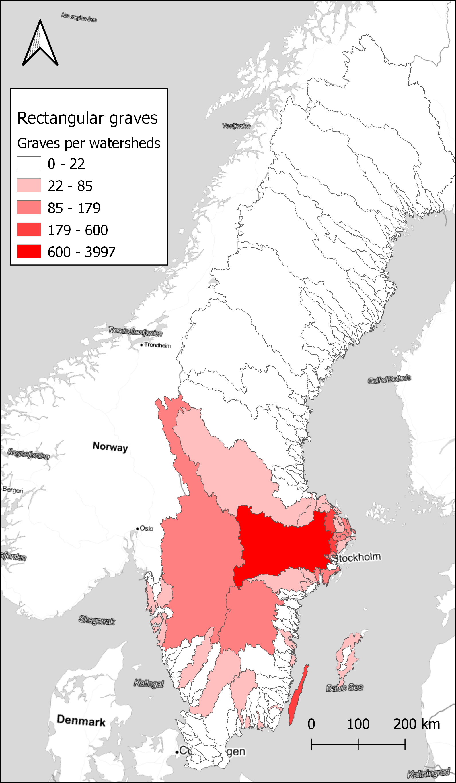
Data from NHB/RAÄ Kulturmiljöregister (KMR), 2022-08-16 and SMHI, the Swedish Meteorological and Hydrological Institute, Huvudavrinningsområden 2016. Map tiles by Stamen Design, under CC BY 3.0. Data by OpenStreetMap, under ODbL.
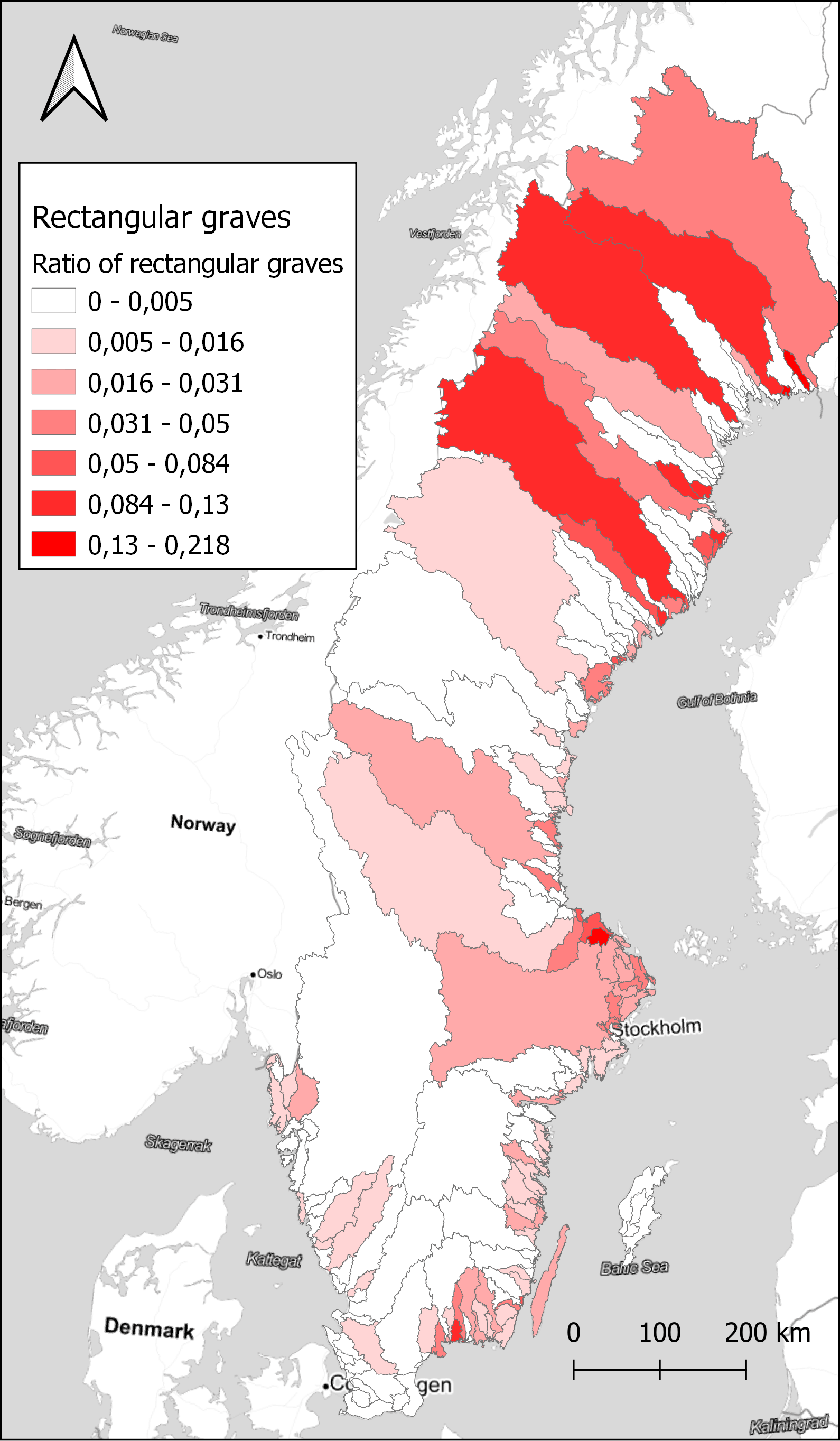
Data from NHB/RAÄ Kulturmiljöregister (KMR), 2022-08-16 and SMHI, the Swedish Meteorological and Hydrological Institute, Huvudavrinningsområden 2016. Map tiles by Stamen Design, under CC BY 3.0. Data by OpenStreetMap, under ODbL.
The restructuring of data that Inglämnlagare provides makes the full range of information of the HER variable “ing_lamn” available for analysis. While the information in the array variable can be queried and extracted for limited questions already as it is, the possibility to work with quantitative methods on the whole dataset opens new ways of approaching the material. There is much specific information that might be useful here, such as the characterisation of features that are part of settlements, and thus not visible from the site level information by itself. As the origin of the record is the systematics surveys that were carried out in Sweden during the 20th century, sites that have been recorded are primarily those that are visible above ground (Jensen 1997). With half a million graves in the database, this material can lend itself to intra-regional analysis, something that was an influential branch of Swedish archaeology, especially in the 1960s and 1970s (Ambrosiani 1964, Hyenstrand 1974). It is, however, important to remember that there are substantial quality issues with the record. The information was collected over a long time, and policies and guidelines changed considerably during this period. In some parts of Sweden there has been specific rounds of survey in later time, such as within the project Skog & Historia (Hermodsson 2003). This means that some areas have been much more thoroughly surveyed compared to others, and different definitions of what should be recorded mean that there are differences in which sites were recorded in different areas, depending on at what point in time they were surveyed (Jensen 2006). The record is also incomplete since much of the archaeological remains are not visible above ground. When archaeological investigations are carried out there are often new sites found, including graves and burial grounds (Löwenborg 2010). Any analysis of the record must thus take into consideration these limitations.
The HER record is now updated with the results of excavations at a general level, with information about the features found during excavations, such as graves, hearths, houses etc. However, the full documentation from excavations is still only partially collected, with find lists as a start, but the full documentation with GIS data and other databases is currently not made available in a systematic way. With the ongoing development of a digital archive at the NHB, and the newly founded national infrastructure for digital archaeology in Sweden, SweDigArch, this will probably change in the future. More data will thus be collected and made available for Swedish archaeology in the future. With rich data from excavations, both the volume and complexity of data will increase considerably, and there will be a need for new tools to make the most of this information, to lay out the ever-growing puzzle of information about the past.
While Inglämnlagare specifically address the data structure for the HER record, the case study can also serve as an example of how open-source technical solution can be used to rework existing datasets. In this context, regular expressions provide a powerful asset in extracting and restructuring data provided in a compact array with much information in individual values of a table.
| Views | Downloads | |
|---|---|---|
| F1000Research | - | - |
|
PubMed Central
Data from PMC are received and updated monthly.
|
- | - |
Provide sufficient details of any financial or non-financial competing interests to enable users to assess whether your comments might lead a reasonable person to question your impartiality. Consider the following examples, but note that this is not an exhaustive list:
Sign up for content alerts and receive a weekly or monthly email with all newly published articles
Already registered? Sign in
The email address should be the one you originally registered with F1000.
You registered with F1000 via Google, so we cannot reset your password.
To sign in, please click here.
If you still need help with your Google account password, please click here.
You registered with F1000 via Facebook, so we cannot reset your password.
To sign in, please click here.
If you still need help with your Facebook account password, please click here.
If your email address is registered with us, we will email you instructions to reset your password.
If you think you should have received this email but it has not arrived, please check your spam filters and/or contact for further assistance.
Comments on this article Comments (0)