Keywords
Micro-Scale, Transport, Built Environment, Transit-Oriented Community, Transport Supply System, Sustainable Development, Mobility Hub
Micro-Scale, Transport, Built Environment, Transit-Oriented Community, Transport Supply System, Sustainable Development, Mobility Hub
In this version of the article, the authors made some edits as follows:
•"Introduction": It derived the MSTBE's scopes from two international case studies in Canada and the United Kingdom. From these case studies, the authors have derived lessons that will be useful for the research's case study development phase. Lastly, it defined the Mobility Hub Accreditation, which will be used in the results and discussion section.
•"Research problem": It explained that the existing MSTBEs all over Alexandria are unsustainable owing to their lack of three scopes, according to many facts.
•"Study aim": It redirected the authorities' focus from the strategic plans to be switched over to the existing MSTBEs in the cities and also established a method that includes three phases to establish an 800m radius micro-scale transit built environment. Lastly, the objectives of the study are described in three points.
•"Data collection": It mentioned two international case studies in Canada and the United Kingdom and derived lessons from both of them about what needs to be done to move towards sustainability and completion in a micro-scale transit built environment, which will be used for the research's case study development phase.
•"Analysis phase": Table 2 showed the SWOT analysis for each mobility hub zone as shown in Figure 3-2, with reference to Table 1.
•"Development phase": Major points for the development of the drastic changes in the current state of the whole case study area based on the demands of each mobility hub zone were mentioned.
•"Results and discussion": It was rewritten to present the results, the highlights, and more discussion details.
•"Conclusions": It was rewritten to help the readers understand why the research should matter to them after finishing reading it.
•Table 6 and Table 7 were added.
See the authors' detailed response to the review by Atef Ahriz
See the authors' detailed response to the review by Ghada Hassan
A micro-scale transit built environment (MSTBE) refers to neighbourhood-specific urban design that integrates relevant built environment and transportation indicators. It is the smallest scale since it deals with internal trip capture, relative friction, and the pedestrian environment.1 The authors split the sustainable MSTBE into three scopes: transit-oriented communities (TOCs), sustainably developed transit supply systems, and the mobility hubs (including their zones), all of which are supported by transit frameworks, strategies, solutions, and guidelines (see Figure 1-1). The authors derived these three scopes from two international case studies in Canada and the United Kingdom (see Data collection, Methods). From these international case studies, the authors have derived lessons that will be useful for the research’s case study development phase.
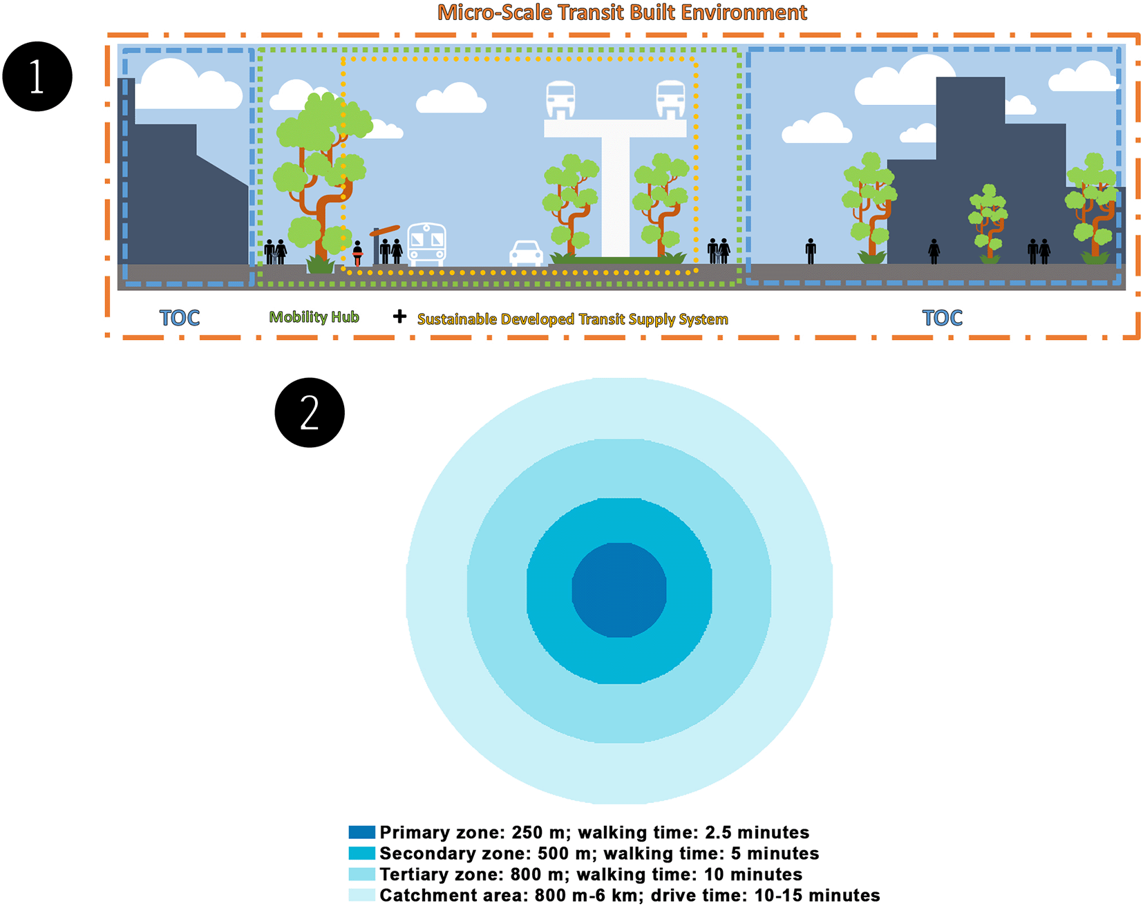
TOCs are walkable, compact, and well-connected neighbourhoods. These neighbourhoods are intended to encourage active transportation by focusing on high-density, mixed-use, and pedestrian-friendly development within the walking distance of frequent transit and utilising mobility management strategies to reduce unnecessary driving. TOCs must be regarded as part of the government's attempt to establish sustainable and innovative means of transportation. The TOC approach aims to aid in developing communities based on transit stations to increase ridership, alleviate traffic congestion, and enhance housing and job opportunities. All of this contributes to the development of entire communities based on solid urban planning and design guidelines. Collaborating to create TOCs has the following primary advantages: the building of complete communities, added value, the creation of a mix of uses, a vibrant public realm, and prominence.2–4
Transit infrastructure and transit services are components of a sustainably developed transit supply system. Transit infrastructure consists of the basic facilities, structures, equipment, technologies, and services that support economic activity and quality of life. It promotes local and regional development by facilitating the flow of goods, connecting production centres with markets, and facilitating people's movements by providing access to work, social opportunities, health and educational facilities, and other services. At the same time, transit services encompass all services (sea, air, land, inland waterways, surveying, and pipelines) that involve the movement of people and products (freight), the rental of carriers with a crew, and related support and auxiliary services – the type and quality of transit services in a neighbourhood influence the establishment of a TOC. Transit service types can be selected based on speed reliability, regardless of infrastructure, and local access attributes are primarily determined by the right-of-way (ROW) type and station or stop spacing.
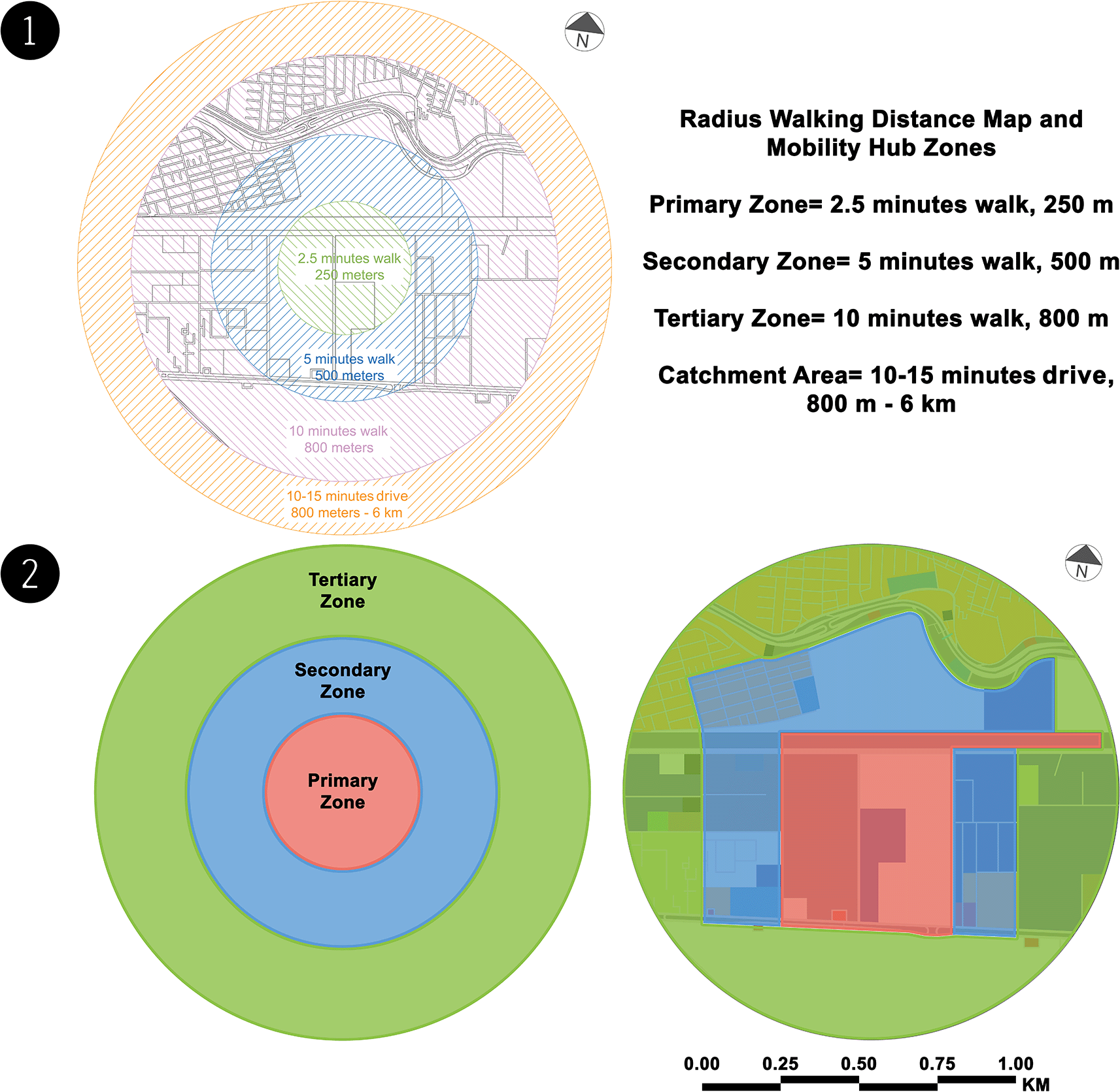
A mobility hub is a multimodal transportation centre that includes major transit stations and their surrounding areas (approximately 10 min/800 m radius), that connect transit, active transportation, and car commutes and that increase the use of shared modes with an emphasis on employment, living, shopping, and/or recreation. This type of hub is frequently seen as a location where new transportation technology and services can be integrated and utilised to improve user experience and increase transportation alternatives for first- and last-mile travel. As the origin, destination, or transfer point for many trips, a mobility hub plays a vital role in the regional transit system. Mobility hubs come in a variety of shapes and sizes, ranging from city centre hubs to suburban small stations, from those directed to rural environments to those oriented towards tourism.5–7 Collaborative Mobility UK (CoMoUK) developed Mobility Hub Accreditation to provide a set of guidelines for evaluating the quality of mobility hubs. The guidelines include six criteria for effective scheme design: visibility and accessibility, sustainable mode selection, safety, ease of switching modes, practical amenities, and social and community appeal. When planning the process and understanding the needs and potential in each area, it is common practice to split a mobility hub into zones. The four zones are the primary zone, secondary zone, tertiary zone, and catchment area (see Figure 1-2).8
There have recently been statements that Alexandria's ongoing and future transportation projects will be implemented, such as the high-speed train El Ain El Sokhna-Marsa Matrouh, the Alexandria Metro (Abu Qir-Misr Station), Raml Tram Rehabilitation, and the Establishment of Central Stations on the Express Train Track. These statements are on the official website of the Egyptian National Authority for Tunnels.9–12 From the perspective of the authors, accepting these projects is unfeasible because the existing MSTBEs all over Alexandria are unsustainable owing to their lack of scopes: TOCs, sustainably developed transit supply systems, and mobility hubs. Even if there are one or two scopes, the MSTBE will be incomplete.
According to many facts, the Alexandrian MSTBE is incomplete. First, current Alexandrian TOCs are imperfect communities based on poor design principles and have no sustainable guidelines to guide the urban design of qualified transit stations and their surroundings, which results in passenger discomfort. Passengers encounter problems in direct and indirect ways, and therefore, passengers are averse to using public transportation and are forced to use private cars. Second, there are delays in receiving new transit supply system technologies that are currently being developed or that are expected to be implemented over the next five to ten years as a consequence of the authorities’ faltering. Lastly, each mode of public transportation operates independently, without integration with other transit systems, and does not facilitate passengers’ movement from the start to the end of their trips.
The study’s aim is to redirect authorities’ focus from strategic plans to the existing MSTBEs of cities. This research establishes a sustainable urban design for MSTBE by gathering, studying, capturing image survey data on the current state of the case (see Data availability13), and using SWOT analysis to create a seamless integration built environment in an 800m radius around various transit mode intersections, provide arrival and departure passengers with mobility comfort throughout the hierarchy of access, and promote a shift in travel behaviour to the greatest extent possible through relevant decision-making, such as transit system planning, design, financing, and operation. Another aim is to create a method that includes phases supported by transit frameworks, strategies, solutions, and guidelines to establish an 800 m radius micro-scale transit built environment.
The interaction and balance between transportation, land use, and place-making functions were used throughout to meet the objectives of the study, including the following:
• Establishing TOCs, which, by design, encourage people to drive less, walk, cycle, and cross more, with a concentration on high-density mixed-use development on a human scale around frequent transit stops and stations.
• Developing an environmentally friendly transportation supply system.
• Creating a mobility hub to merge several forms of transportation into a single focal point.
Our research paper has no relevance to studies involving humans (individuals, human data, or material) or human participants, including personal genomics studies or clinical trials. Therefore, the authors are not concerned with the Helsinki Declaration. Any individual or attendant from any of the institutions visited during this research does not necessitate any protocol or consent from the individual for the use and publication of data in Egypt. Ethical approval must be obtained only when information is not open access.
The “Enhanced MSTBE Phases” methodology was created by the authors to establish a sustainable MSTBE, including documentation, analysis, and development. This methodology was the one that was used for the key elements of the study design used in this research, depending on data collection.
Approval requests: Formal requests were made for information and approvals to the transport institutions to obtain approval to use and share the data and not to face any objections throughout the research operation.
Techniques: The techniques involved looking for documents, maps, manuscripts, and references related to transportation in Alexandria and photographing the case study site by using a digital single-lens reflex (DSLR) camera with a professional camera tripod, a padcaster tripod dolly wheel, and a smartphone with a DJI Osmo Mobile 3 Gimbal for the smartphone.
Analysis Method: SWOT analysis was used as a tool to determine the strengths, weaknesses, opportunities, and threats of the case study site.
The study focused on the MSTBE in Alexandria and highlighted the Muharram Bek El Mowkaf El Gedid Mobility Hub (MBMH) and the 800 m radius surrounding it as the case study. The authors established a proposal for the MBMH and the 800 m radius surrounding it. This study used the “Enhanced MSTBE Phases” methodology, which was created by the authors, to establish a sustainable MSTBE, including documentation, analysis, and development.
Data collection depended completely on the documentation phase, which was the first phase where data and information were collected. From this phase, the authors were able to complete the next phases. The first phase was documentation, which included researching and gathering information and data on the current state of the case. This phase was divided into four aspects, including visits, photography, drawings, and TV shows. The second phase included conducting an overall analysis of the data collected in the first phase, utilising SWOT analysis. Depending on the two prior phases, the third phase came with a proposal for the case study.
Also, the authors used two international case studies’ lessons, as well as data collection, about what needs to be done to move towards sustainability and completion in a MSTBE: the Kennedy Station Mobility Hub in Toronto, Canada, and the London King’s Cross in London, United Kingdom.
The Kennedy Station Mobility Hub highlighted the development of strong public areas that integrated numerous means of transit. We picked out the following lessons from it:
• Long-term phasing strategies should ensure that current infrastructure does not impede future development opportunities.
• Develop a coherent design language for the station site by incorporating the landscaping strategies developed for public spaces and plazas around the station into the public realm treatment of other station amenities such as the bus terminal, stops, and passenger pick-up and drop-off areas.
• Street improvements provide vital neighbourhood connections to and from the station.
• Continuous cooperation of all stakeholders with the competent authorities has a great impact on the streets’ placement and layout.
• Connecting existing roads with new roadways is necessary to make development plots accessible and provide a more continuous, grid-like road layout in general.
• Consider some unique options in mobility hubs to mitigate these visual impacts due to the inconvenience associated with the overall development, train corridors, bus traffic, and security gates.
London King’s Cross’s Regeneration Programme involved converting a community in central London into a mixed-use urban regeneration project and showed how rail companies can increase real estate market value near a central railway hub by improving connectivity, public space, public-private partnerships (PPPs), and public consultation. We picked out the following lessons from it:
• Any development requires long-term commitment and flexibility from all parties to reflect and respond to evolving market needs.
• Active community involvement ensures stronger stakeholder engagement and better outcomes.
• Market value can be created around well-connected hubs with great market potential and quality public spaces.
• Keep the PPP concept in mind, which entails financing infrastructure and property development as well as building and operating various projects to achieve a compromise between the developer’s long-term goals of creating and managing an estate and the local government’s desire to incorporate development into the communities that surround it.
As mentioned earlier, this phase was divided into four aspects:
Visiting relevant transport institutions: Visits were made to the General Authority for Passenger Transport in Alexandria, Public Authority for Planning Transport Projects, National Railway Authority of Egypt, Ministry of Transportation, and Directorate of Housing and Utilities–Alexandria. Appointments were made:
• To view documents, maps, manuscripts, and references related to transportation in Alexandria, such as the Strategic General Urban Plans, which were prepared by the Egyptian General Organisation of Physical Planning (GOPP) in collaboration with other authorised accredited local and foreign organisations: the Maclean Plan 1921 and General Plan (GP) 1959, GP 2005, GP 2017, GP 2025, GP 2032, and GP 2050 (the authors have collected the plans into two figures; see Data availability,13 “Strategic General Urban Plans (1).jpg” and “Strategic General Urban Plans (2).jpg”).
• To have some available public notes for the transit projects in Alexandria that may be helpful in the study, such as titles of ongoing projects and whether they are on schedule i.e., the high-speed train El Ain El Sokhna-Marsa Matrouh, the Alexandria Metro (Abu Qir-Misr Station), Raml Tram Rehabilitation, and the Establishment of Central Stations on the Express Train Track, as the Egyptian National Authority for Tunnels announced about them; the Alexandria urban transport study is financed by the neighbourhood investment facility from the European Union and managed by the French Development Agency (Agence Française De Développement); the Egyptian Government commissioned EGIS rail, a French advisory office, to prepare a long-term scenario for the Alexandria governorate strategic plan for urban transportation consistent with urban planning for the city; and a partnership between SYSTRA, AECOM, Orascom Construction SAE, The Arab Contractors, Siemens Mobility, and other companies with the Egyptian ministries to consult, design, install, commission, and maintain the systems for the projects.
• To facilitate the operation of capturing image survey data on the current state needed for the case study.
Prior to the visits, the authors submitted “Formal Requests for Information and Approval”, signed by the Vice Dean for Graduate Studies and Research, Prof. Sahar Mahmoud Al-Arnaouti, and stamped by the Faculty of Fine Arts, to the transport institutions and obtained approval to use and share the data.
For the copies and translation of the formal requests for information and approval, see Data availability.13
Capturing image survey data: The authors used the following photography and panoramic photography tools to acquire image survey data: (1) a DSLR camera with a professional camera tripod, (2) a padcaster tripod dolly wheel, and (3) a smartphone with a DJI Osmo Mobile 3 Gimbal for the smartphone to capture image survey data on the current state of the case study (see Data availability,13 “00 Capturing Image Survey Data Tools.jpg”, “01 Primary Zone.jpg”, “02 Secondary Zone.jpg”, and “03 Tertiary Zone.jpg”).
Overlaying, tracing, drawing, and presenting: The authors used the maps obtained from the institutional archives (the authors have collected the plans into two figures; see Data availability,13 “Strategic General Urban Plans (1).jpg” and “Strategic General Urban Plans (2).jpg”) and the exported images from Google Earth Pro (see the software availability statement for alternatives) to draw the new Alexandria Transit Map by overlaying and tracing with Autodesk AutoCAD (see the software availability statement for alternatives). Then, the authors cropped the case study zone from it and presented the case study zone using Adobe Photoshop (see the software availability statement for alternatives).
Transcribing announcement on TV shows: On the “Al Hekaya” TV talk show, presenter Amr Adeeb and Kamel El-Wazir, the minister of transport of Egypt, announced official transportation news about the transit developments in Egypt and Alexandria (see Data availability,13 “Official Transportation News through the Media.pdf” provides descriptions of the news).
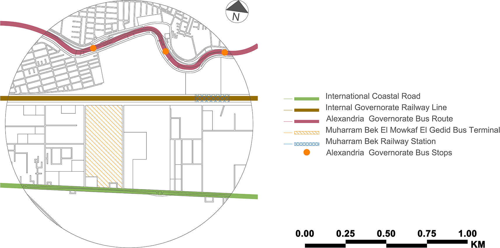
After conducting comprehensive research and data collection, the authors selected the MBMH as the case study zone from among 23 mobility hubs indicated on the new Alexandria Transit Map. The case study zone is located in Alexandria's core area and includes the 800 m radius surrounding the Muharram Bek El Mowkaf El Gedid Bus Terminal. Before the 1952 revolution, the Muharram Bek neighbourhood was considered an elite neighbourhood, with mansions and villas dominating the area. In accordance with GP 2032, an electric high-speed rail terminal will be constructed in front of the Muharram Bek El Mowkaf El Gedid Bus Terminal. Table 1 presents the current profile for the case study zone.
The Muharram Bek El Mowkaf El Gedid Bus Terminal is the new bus terminal for regional and national bus connections located in Alexandria's Muharram Bek area. Construction of it began in 2001 and was completed in 2003. It is operated by the National Company for Road Construction and Development and serves as the primary departure and arrival point for passengers travelling by land to and from Alexandria. It was considered an alternative to the old bus stop at the Sidi Gaber Train Station before all buses and taxis for the governorates were relocated to the present location. Public transportation runs across the case study zone (see Figure 2). However, there is no integration between two or more public transportation modes. Arriving passengers could use the train, but since the current Muharram Bek railway station is more than 1 kilometre distant, they cannot. An extra stop along the new suburban train line would be beneficial, and getting to the Misr Station Train Station is also difficult. Although the Misr Station is approximately 2 kilometres distant, the railway line prevents pedestrian access to the city centre.
There is currently no mobility hub in the case study. However, the authors created a radius walking distance map to identify and analyse the mobility hub zones (see Figure 3-1). The following table (see Table 2) shows the SWOT analysis for each mobility hub zone (see Figure 3-2), with reference to Table 1. SWOT analysis is used to investigate the current and initial conditions of the planned hub site and its surroundings. Analyse existing transport networks, including street connections, cycling, pedestrian infrastructure, and public transport. This review included land use, urban form, and neighbourhood character to fully capture the context of the site. Redevelopment opportunities on and around the site were analysed to understand the potential of mobility hubs to support transit-oriented development. Finally, the site's constraints and opportunities are discussed to determine which elements of the mobility hub are best suited to the site's current issues and build on its strengths. In addition, the view of documents, maps, manuscripts, and references related to transportation in Alexandria, notes taken from visiting relevant transport institutions, and El-Wazir's explanation of official statements from transcribing announcements on TV shows helped the authors build the outline description of the current situation for the SWOT analysis.
This figure is the authors’ own work. (2) Mobility hub zones – case study zone (present). This figure is the authors’ own work.
| SWOT | Primary Zone | Secondary Zone | Tertiary Zone |
|---|---|---|---|
| Strengths |
|
| |
| Weaknesses |
|
|
|
| Opportunities |
|
| There are development services, i.e., petrol stations, car service centres and a supermarket |
| Threats | There is no provision to guarantee the safety of people crossing the train track from mixed-use land | Pedestrians do not generally use bridges except a few times due to the many stairs on the bridges; pedestrians jump over concrete barriers to pass from one side to the other, often exposing passers-by to danger; some neighbourhood residents made a small ladder bypassing by jumping or using bridges |
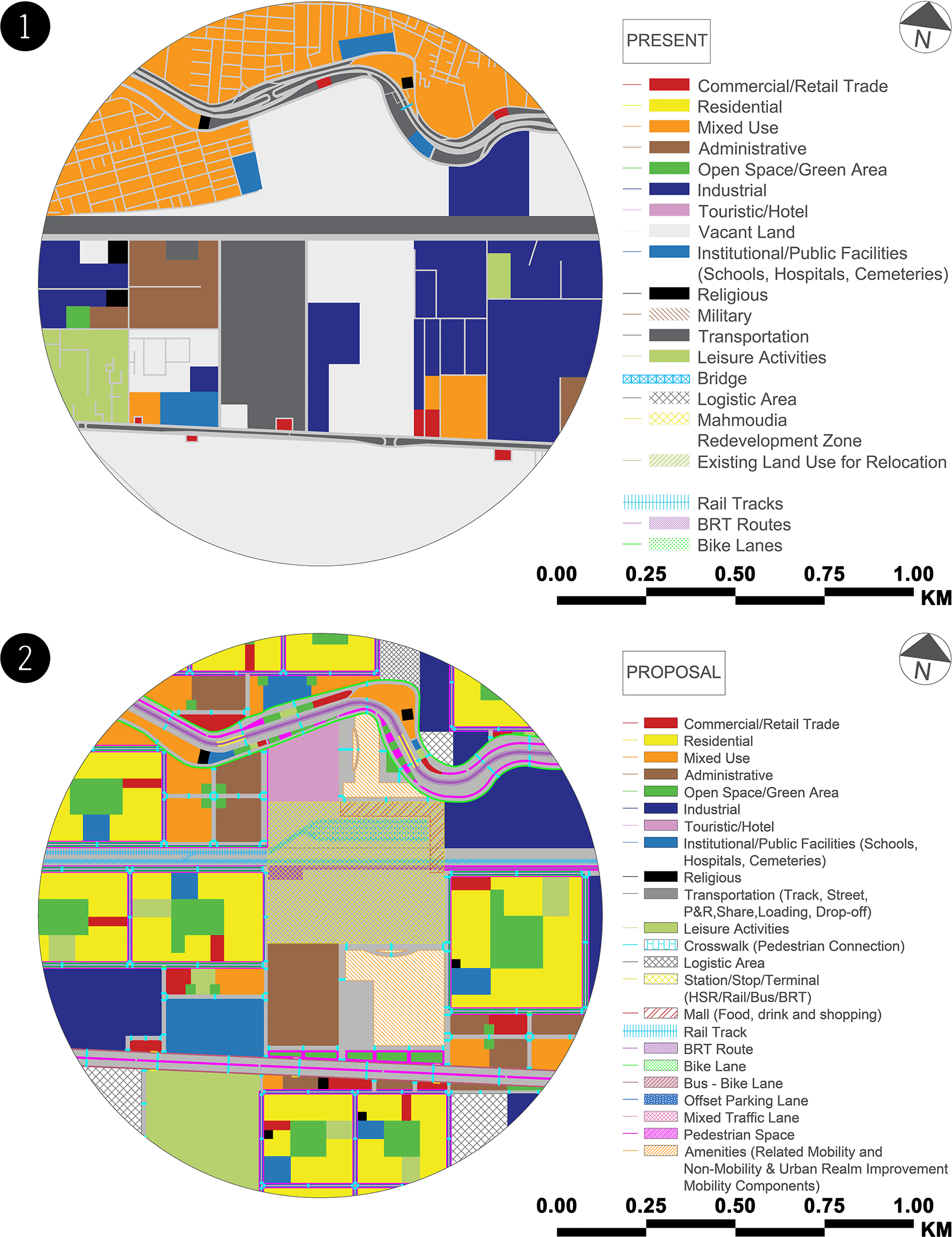
The authors built a vision of development for MBMH to become a mixed-use attraction within the city with a new profile (see Table 4). In Table 3, the authors worked on developing certain multi-dimensional aspects, such as land use, the built form, and open space and circulation, so that they could offer recommendations for the case study zone.
| Land Use | Built Form | Open Space & Circulation |
|---|---|---|
|
|
|
| Item | Description |
|---|---|
| Mobility Hub's Name | Muharram Bek El Mowkaf El Gedid |
| Context | Suburban mixed:
|
| Transport Function | Destination |
| Type | Anchor |
| Scale | City centre mobility hub |
| Infrastructure – Lines & Routes |
|
| Infrastructure – Others |
|
| Transit Modes |
|
| Related Mobility Components |
|
| Non-Mobility and Urban Realm Improvement Mobility Components | |
| Park & Ride | The authors propose relocating the Muharram Bek Train Station to the mobility hub site, accompanying the park and ride |
In regard to the authors’ recommendations, lessons, and guidelines, the authors put the major points for the development of the drastic changes in the current state of the whole case study area based on the demands of each mobility hub zone as follows:
• In the primary zone, the authors focused on utilising this zone on the MBMH and its amenities on both sides of the transit corridors to create a distinctive mobility hub location with appealing streetscapes, reinforce the built form, and transition open space to new residential uses to offer a walkable environment with direct and weather-protected access.
• Secondary zone utilisation is mostly mixed-use development along major transit corridors with enhanced transit services and visible and physical links to the mobility hub.
• Mid-rise buildings are primarily clustered around transit services in the tertiary zone, with the greatest height and density along the railroad track. They supported by a mixed-use development that optimised connections and views.
• The needed services are provided within and around the buildings, considering the heights of residential buildings and open spaces.
• Took into account the distance between stops and stations and the smoothness of the traffic flow.
• Living streets are settled with two alternative street widths for the neighbourhood, one of which is 14 metres and the other is 20 metres.
• Cycle infrastructure is settled along transit corridors and within residential buildings, creating safe and direct connections across the transit corridors.
• Urban street elements are settled to contribute to the safety and attraction of urban streets for people walking, shopping, parking, and driving. The proposal used dedicated median bus lanes, gateways, bus stops, bike corrals, bike share stations, parklets, and crosswalks.
As shown in Figure 4 and Figure 5-2, the authors took several phases into account, including the accumulation of lessons, information, and data and the analysis and development of the current state, in order to have acceptable results in the long run, even though there were negative results. The proposal achieved the following:
• In the primary zone:
○ Locating Muharram Bek Railway Station (after relocation), Alexandria High-Speed Rail Terminal, Muharram Bek El Mowkaf El Gedid Bus Terminal and Alexandria Governorate Bus Stops in this zone will be the busiest in terms of mobility.
○ This zone will prioritise high levels of pedestrian and transit traffic while balancing many station access routes.
○ This zone will encourage high levels of flow as well as maximum intensity and diversity in order to create a diverse and active hub of activity for the local population.
○ This zone will provide travellers with facilities through development.
• In the secondary zone:
• In the tertiary zone:
• At the three scopes of the MSTBE:
○ Implementation of some of Alexandria’s ongoing and future public transportation projects will develop transit infrastructure and services, which will be supported by advanced sustainable programmes, technologies, frameworks, and guidelines to ensure their environmental, social, and economic impacts in Alexandria.
○ The MSTBE’s design will support frequent use within 400 metres of regular transit and 800 metres of ongoing or planned rapid transit stations and will support the adequate crossing of high- and low-density areas.
○ Utilisation of high-market-value creation, public-private partnerships, and long-term perspective approaches will enhance the MSTBE.
○ Creation of mobility hub will connect transit, active transportation, and vehicle commutes to enhance the use of shared modes. They will be frequently integrated with public, commercial, or residential amenities to create a dense urban environment.
○ Integrating transportation and neighbourhood development into TOCs will make commuting more accessible and faster. This approach will allow for the creation of vibrant, mixed-use neighbourhoods that are linked to mobility hubs.
○ The MSTBE will benefit from the use of transit passenger facility design principles and station design guidelines.
○ The MSTBE will include a complete network of sidewalks and other facilities that will be beneficial to all users, even people with disabilities.
○ Land use patterns for green areas or large-scale redevelopment sites will be created in tandem with walking, cycling, transportation, infrastructure, and services to connect communities to key commuter locations.
○ Offset Parking Lanes will handle high volumes of traffic and improve both stability and travel time on streets near or beyond vehicular traffic.

In addition to the proposal’s achievements, the authors wanted to ensure that they had distributed the land uses fairly, so they estimated the exact percentages of the land uses for each mobility hub zone in the case study in the current and proposed states and compared them (see Figure 5 and Table 5); the result was acceptable under the guidance of the two international case studies. And also, they evaluated the MBMH using the city centre mobility hub’s CoMoUK accreditation assessment, and the mobility hub was awarded CoMoUK Gold Accreditation (see Table 6).
Out of all the above outcomes, the overall results are positive, as the authors expect that if the proposal is implemented as intended, it will be the starting point to ensure that the micro-scale transit built environment is a catalyst for future influences that will affect meso-scale and ultimately macro-scale transit built environments in the long run.
Transportation has changed dramatically in the last decade. Demographic changes, increased urbanisation, and changes in employment types and arrangements have put additional demand on existing transportation and transit networks. That is why the authors focused on the existing MSTBEs of cities to prepare Alexandria to accept ongoing and future transportation developments that will complement local transit.
This research used the MBMH as a case study as a starting point for applying “Enhanced MSTBE Phases” methodology in Alexandria, Egypt, where the case study was documented, analysed, and developed to be sustainable. Throughout the methodology’s application, the authors ensured that the development must start from the smallest scale (micro-scale) of the built environment to the next scales (meso-scale and macro-scale), as well as that people’s behaviour is always affected by the design of the built environment (MSTBE). Moreover, when the authors compared land use percentages and used mobility hub’s CoMoUK accreditation assessment, the results were positive, which indicated the authors’ success in the methodology’s application.
Following the successful methodology’s application to the case study, the authors anticipate that if this method is applied to the other 22 proposed mobility hubs at MSTBEs, the influences of the MSTBEs will reach the meso- and macro-scales. Moreover, Alexandria Strategic General Urban Plans’ Transportation Sector Five Goals (Support Decentralised Concentration, Improve Quality of Life & Environmental Quality, Stimulate Successful Socio-economic Development, Promote Cultural and Architectural Heritage, and Support Planning Policies for Implementation) would be achieved, which would affect the whole governorate’s urban planning and housing, urban and economic development, transportation, and the environment in the future, as shown in Table 7.
• Google Earth Pro free alternative: OpenStreetMap.
• Autodesk AutoCAD free alternatives: FreeCAD and LibreCAD (2D).
| Views | Downloads | |
|---|---|---|
| F1000Research | - | - |
|
PubMed Central
Data from PMC are received and updated monthly.
|
- | - |
Provide sufficient details of any financial or non-financial competing interests to enable users to assess whether your comments might lead a reasonable person to question your impartiality. Consider the following examples, but note that this is not an exhaustive list:
Sign up for content alerts and receive a weekly or monthly email with all newly published articles
Already registered? Sign in
The email address should be the one you originally registered with F1000.
You registered with F1000 via Google, so we cannot reset your password.
To sign in, please click here.
If you still need help with your Google account password, please click here.
You registered with F1000 via Facebook, so we cannot reset your password.
To sign in, please click here.
If you still need help with your Facebook account password, please click here.
If your email address is registered with us, we will email you instructions to reset your password.
If you think you should have received this email but it has not arrived, please check your spam filters and/or contact for further assistance.
Comments on this article Comments (0)