Keywords
COVID-19, SAR-CoV-2, maximum wind speed, average wind speed, spatial–temporal analysis
This article is included in the Emerging Diseases and Outbreaks gateway.
COVID-19, SAR-CoV-2, maximum wind speed, average wind speed, spatial–temporal analysis
Several nations are currently experiencing a significant increase in coronavirus (COVID-19) cases, including Indonesia (https://worldometers.info/coronavirus/). A total of 34,874,744 confirmed cases with 1,097,497 deaths (case fatality rate (CFR) 3.1%) were reported in 216 countries based on data from the World Health Organization (https://www.who.int/docs/default-source/coronaviruse/situation-reports/20200831-weekly-epi-update-3.pdf?sfvrsn=d7032a2a_4). In Indonesia, the number of people who have been infected and the number who have died are approximately 287,008 and 10,740 (CFR 3.7%), respectively, with the most predominant regions being Jakarta (73,700), East Java (43,536), and Central Java (22,440) (https://covid19.go.id/peta-sebaran).
Based on various studies worldwide, the SARS-CoV-2 virus that is responsible for COVID-19 is described as highly contagious. Saliva droplets produced by asymptomatic carriers appear to be the possible transmission media. In addition, specific observations using highly sensitive laser beams indicated that loud speech tends to emit countless droplets of oral fluid per second. In a closed and stagnant air environment, the drops finally disappear from the viewing window within the range of eight to14 minutes. Based on these findings, regular speech shows a high probability of transmitting the airborne virus in confined spaces.1 Therefore, aerosol transfer appears to be the most significant method of SARS-CoV-2 spread compared with other media.1–3 Furthermore, recent studies have shown that the virus remains active in airborne particles beyond three hours.4,5
Although related studies are minimal, the wind is perceived as a critical climatic factor for virus transmission.6 Previous research studied four meteorological parameters (temperature, dew point, humidity, and wind speed). The number of coronavirus cases in Turkey demonstrated the function of wind speed in promoting the spread. The parameter with the highest correlation was generated by wind speed in 14 days and therefore showed that extensive wind speeds led to increased virus cases.7
Conversely, higher wind speeds in external settings contribute to dilution and droplet removal, resulting in a decline in airborne concentration (https://apps.who.int/iris/bitstream/handle/10665/70863/WHO_CDS_CSR_GAR_2003.11_eng.pdf?sequence=1&isAllowed=y).8 Previous research from Brazil that examined the association between weather and COVID-19 spread in tropical climates countries showed that wind speed was negatively correlated (p < 0.01). Therefore, the variable also serves as a potential consideration in suppressing disease transmission.9
Based on the description above, it can be assumed that wind speed is a major influencing factor of COVID-19 spread. Therefore, it was crucial to comprehend the effects of wind speed on the virus, as Jakarta appeared to be the pandemic's epicenter. Consequently, this research successfully investigated the relationship between wind speed and the weekly occurrence of COVID-19 in the Special Capital Region of Jakarta.
A step by step description of the protocols can be obtained at: dx.doi.org/10.17504/protocols.io.ewov1odzylr2/v1
A quantitative method was applied with an ecological design that provides real-time and location analysis, using geographic information systems and the data were tested using statistical techniques.
The secondary data comprised daily reports of COVID-19 infection and wind speed (maximum and mean) in Jakarta from the pandemic inception, specifically between March and September 2020. These records were obtained from the website of the Jakarta Provincial Health Office (https://corona.jakarta.go.id/id/data-pemantauan) and the website of the Indonesian Meteorology, Climatology and Geophysics Agency (https://dataonline.bmkg.go.id/akses_data). Subsequently, the general information was converted into 31-weeks documentation. Furthermore, a basic map of Jakarta with neighboring community boundaries was obtained using the GADM Map and Data site (https://gadm.org/maps/IDN/jakartaraya.html). Coordinates for the weather monitoring stations were accessed online (https://www.gps-latitude-longitude.com/). The Jakarta province comprising 261 urban villages served as the research location.
Univariate analysis was conducted to determine individual variable distribution, including maximum and average wind speed (m/s), as well as the number of COVID-19 cases. This process is descriptive and quantitative, where the data exist in statistical distribution tables, line graphs, and thematic maps based on the research objectives. Subsequently, the bivariate analysis involved Pearson's product-moment correlation test to evaluate the relationship between independent (wind speed factor) and dependent variables (COVID-19). Specifically, the method stated the possible existence (p < 0.05), closeness (r), and direction of the relationship. In addition, the strengths of the association were qualitatively divided into four categories, where r = 0.00–0.25 was absence/weak relationship, r = 0.26–0.50 was moderate, r = 0.51–0.75 was strong and r = 0.76–1.00 was very strong/perfect.(10) The correlation value also determined the direction of the relationship as a positive (+) or negative (−) pattern. This value (r) was evaluated by the conditions, where r = 0 was no linear relationship, r = −1 was perfect negative linear and r = 1 was perfect positive linear.10 Furthermore, the univariate and bivariate analyses were conducted at the Computer Laboratory using SPSS 21 software (RRID:SCR_002865).
Spatial analysis was performed to observe the relationship pattern between the two variables. Based on a selected community, an interpolation process was employed to create an overlay map of COVID-19 cases and climate parameters. The Jakarta grid map interpolation was used to estimate the magnitude of climate variables outside the measurement points (weather stations) by applying the following steps. Firstly, a grid map of five weather monitoring stations was created. The interpolation was performed by entering the point values or coordinate attribute data (longitude and latitude) into the climate variable attribute table. The coordinate points were joined in the climate variable map. Secondly, the independent variable vector data were digitized by inputting the spatial data on climate variables into a base map, then processing and selecting a color symbol (singleband pseudocolor) with color ramp blues. Consequently, a digital category of high and low climate variables was formed depending on the data magnitude. Thirdly, the dependent variable vector data were digitized by entering spatial data on COVID-19 rates into the base map, depending on the community, followed by processing and selecting a point symbol (centroid). A digital category of large and small cases was generated based on the disease data. Fourthly, the two vector maps were interpolated with the plugin interpolation menu. Therefore, an interpolated raster plot was obtained and used to analyze or predict the climate variable values in each community. The resulting color gradations and point symbols did not show any ratio but only reported ordinal values, including high-low climate variations and number of virus cases. This color gradation ranged from dark blue to white, indicating high to low wind speeds (maximum and mean). Subsequently, the colors were created digitally using a singleband pseudocolor with ramp blues colors from Quantum Geographic Information System (QGIS) software (RRID:SCR_018507) with a natural grouping of five classes, where very dark blue = very high, dark blue = high, blue = medium, light blue = and white = very low. The dot symbol (centroid) varied from large to small, representing the virus spread. Similarly, the point symbol size was digitally generated using a simple marker or a standard symbol from the QGIS software with a linear classification between 0 and 17.
The spatially analyzed data were further processed with overlayed thematic graphics and maps to show the relationship pattern based on time and location. The spatial analysis was associated with the statistical correlation results generated using the QGIS software version 3.0 at the Computer Laboratory of the Faculty of Public Health, University of Indonesia.
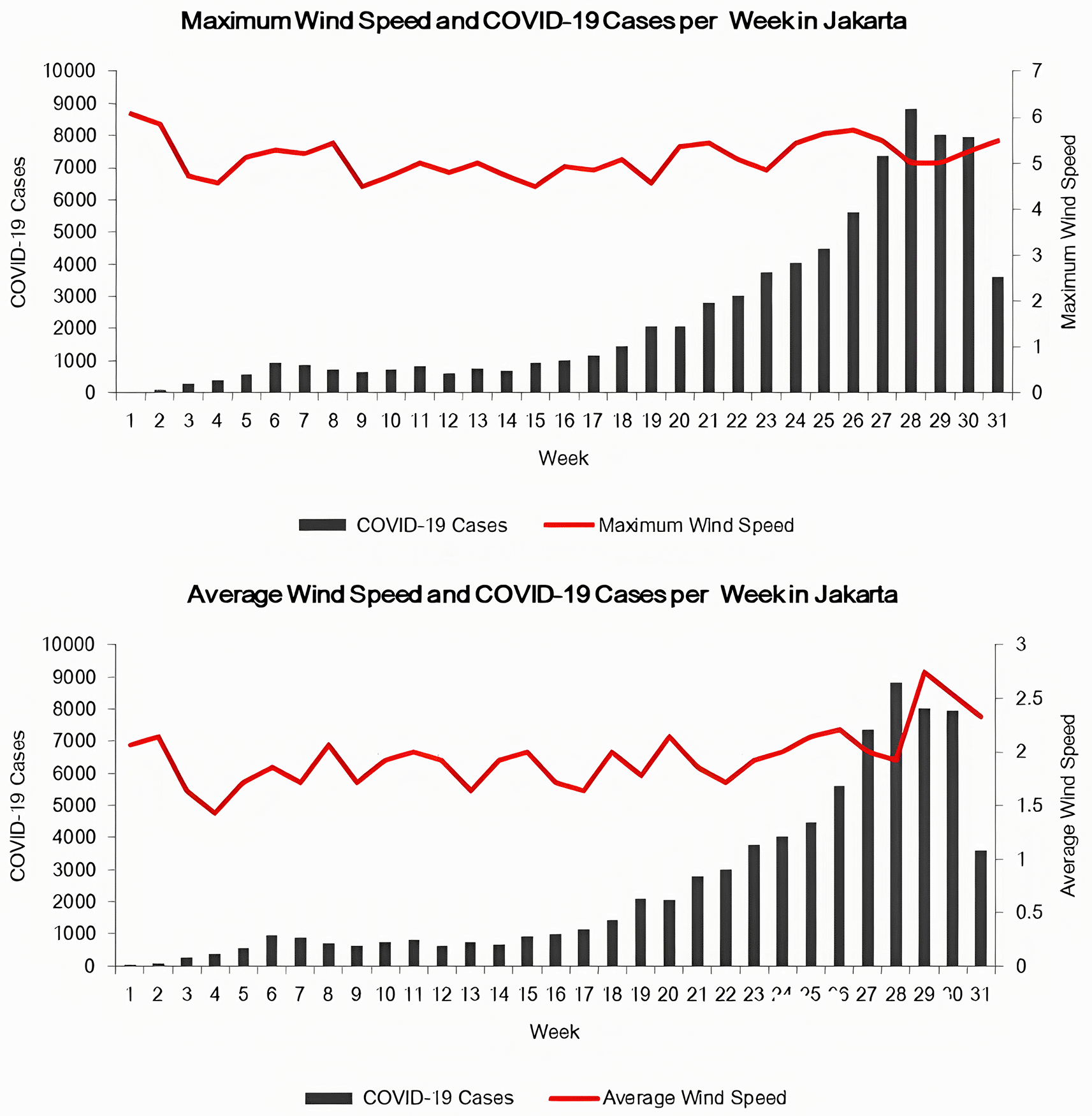
The wind speed (maximum and mean) from March to September 2020 tended to fluctuate between 1.43 and 6.07 m/s. This variable appeared minimal during the last week of each month (fourth, fifth, fourth, fourth, and fifth weeks of March, April, May, June, and July, respectively). However, it showed a higher performance in the middle of each month (second, second, second, third, third, and third weeks of March, May, June, July, August, and September, respectively).
Furthermore, the maximum and minimum wind speed values of 6.07 and 4.5m/s occurred during the first, ninth, and 15th weeks, respectively. Meanwhile, the optimal and minimum average wind speeds of 2.75 and 1.43 m/s were obtained in the 29th and fourth weeks, respectively.
The Pearson product-moment correlation test was applied in the statistical analysis of the relationship to show the occurrence (p < 0.05), direction (positive/direct or negative/opposite), and closeness (r). The Jakarta data from March to September 2020 were processed. The correlation test results between the average wind speed and COVID-19 cases showed a strong relationship strength and a positive pattern (p = 0.002, r = 0.542). These conditions indicated that higher average wind speeds increased the possibility of COVID-19 occurrence. However, no significant relationship existed between the maximum wind speed and the virus occurrence.
Figure 1 shows that wind speeds possibly generated a pattern similar to the COVID-19 cases. The reverse form of the maximum wind speed with COVID-19 cases occurred in the second to fourth, eighth, 15th, 17th, 19th, 22nd, 23rd, 27th, 28th, 30th, and 31st weeks, while for average wind speed, the pattern was observed at weeks three, four, seven, nine, 13, 14, 16, 17, 19–22 and 27–29.
The spatial analysis was created by overlaying a map of COVID-19 cases with a plot of the sunlight duration to obtain the interpolation from the weather monitoring stations. Color gradations and dot symbols represent this interval and the virus occurrence. In addition, the interpolated values were used to predict a relationship between sunlight duration and COVID-19 in each village around the research location.
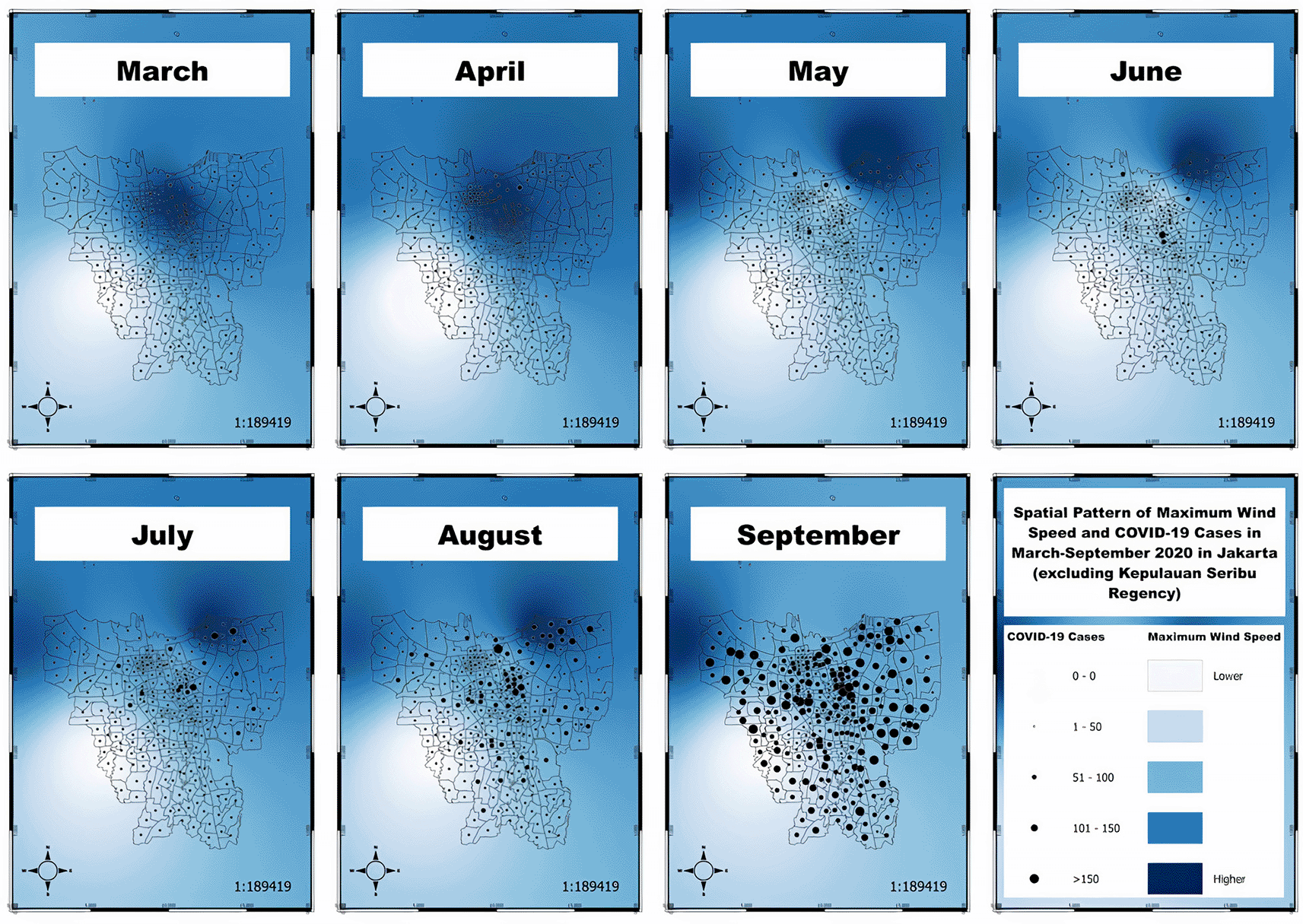
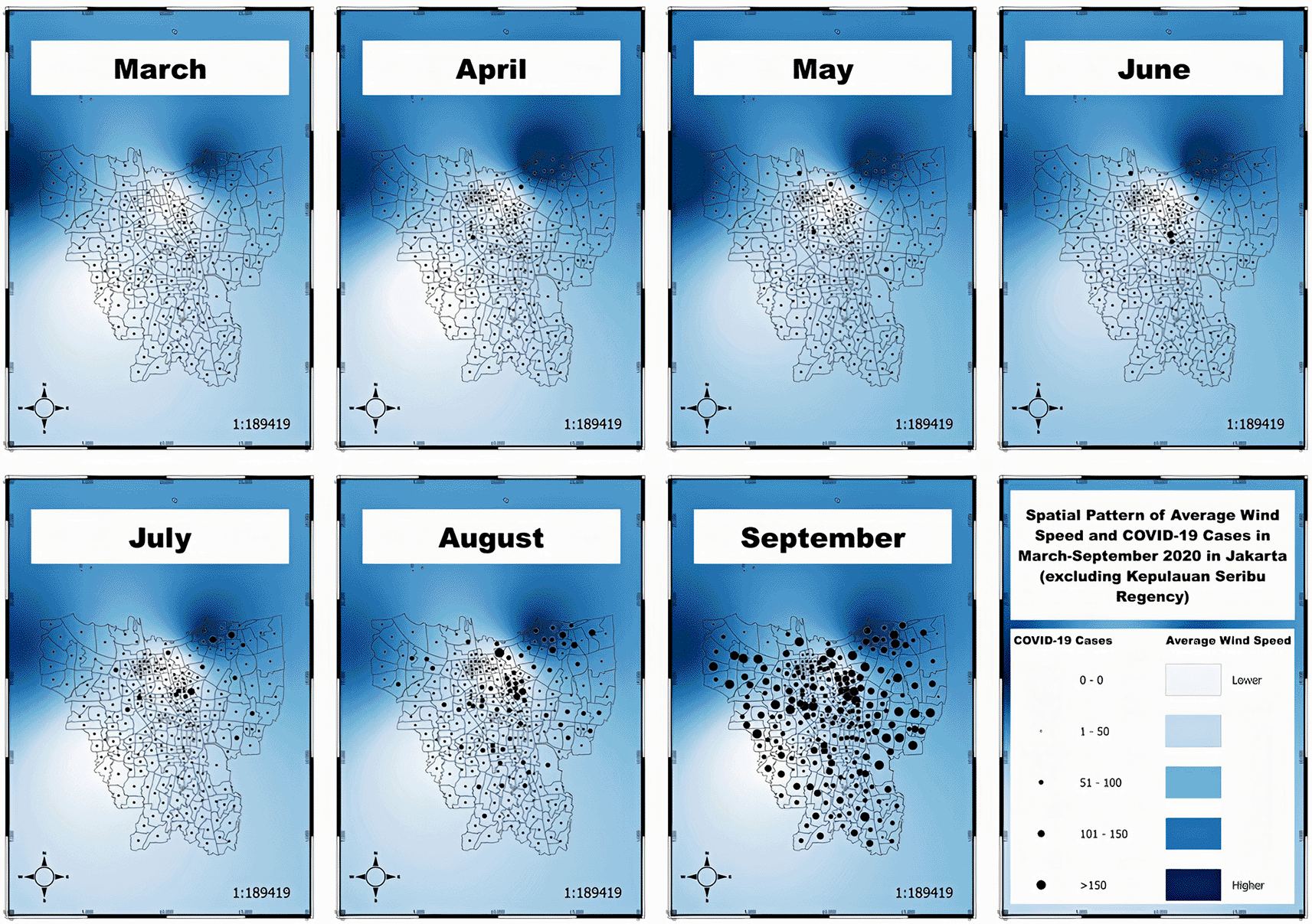
Apart from generating a high-low comparison of sun exposure to the number of COVID-19 cases, the virus transmission pattern from March to September 2020 was also ascertained. There were incomplete data, including the records per village, that commenced from March 25, 2020. This circumstance tended to influence the distribution pattern in March, causing a uniform condition to be a low category.
In each month, the spatial pattern of maximum wind speed tended to fluctuate, including the maximum high wind speed dominating the central and northern parts of the capital city in the first two months (March and April). Subsequently, the flow expanded to the northeast and northwest regions, comprising Tanjung Priok, Koja, Kebon Bawang, Lagoa, Kali Baru, North Rawabadak, South Rawabadak, Warakas, Papanggo, North Tugu, West Semper, Cilincing, and East Semper communities. The maximum moderate wind speed consistently occurred in the southeastern part that included most of the urban villages in East Jakarta. In contrast, low maximum wind speeds were reported in the southwest part relating to the urban villages in South Jakarta.
Based on the spatial map overlaying the maximum wind speed and COVID-19 cases, urban villages with high maximum wind speeds tended to demonstrate faster virus transmission than areas with moderate and low maximum wind speeds. A relatively high spike in cases in July circulated across the villages of Lagoa (101) and Kebon Bawang (10), and in August at Lagoa (144), Cilincing (131), South Rawabadak (105), and West Semper (109), compared with other neighboring villages. However, a small number of villages with moderate and low maximum wind speeds also showed an increase in July at West Cempaka Putih (101), and in August at Johar Baru village (127), and West Cempaka Putih (106), as illustrated in Figure 2.
The spatial pattern of the average wind speed in each month appeared relatively similar, including the high average wind speed dominating the northeast and northwest regions of the city. This area covered Kebon Bawang, Tanjung Priok, Koja, Lagoa, Kali Baru, North Rawabadak, South Rawabadak, Warakas, Papanggo, North Tugu, West Semper, Cilincing, Kramat, Tegal Alur, Pengadungan, Kali Deres, and Samanan. Furthermore, the average wind speed consistently occurred in the areas with high and low average wind speed convergence, including Kapuk Muara, Kapuk, Rawa Buaya, Duri Kosambi, Sunter Agung, Sunter Jaya, West Kelapa Gading, East Kelapa Gading, and Pegangsaan Dua. The low average wind speeds also remained constant in the central and southern parts, including central, south, and east Jakarta.
Based on the spatial overlay map of the average wind speed and COVID-19 cases, villages with high average wind speeds experienced an increase of cases faster compared with areas with medium and low average wind speeds. A relatively high spike also occurred in July at Kebon Bawang (101) and Lagoa (101), and in August at Lagoa (144), Cilincing (131), West Semper (109), and South Rawabadak (105), compared with other adjacent villages. However, a smaller number of villages with medium and low average wind speeds also showed an increase in July at West Cempaka Putih (101), and in August at West Pademangan (158), Johar Baru (127), and West Cempaka Putih (106), as represented in Figure 3.
Based on the correlation analysis between the average wind speed and COVID-19 cases in Jakarta, a significant correction between strong and unidirectional associations was reported, indicating that higher average wind speeds accelerated the virus transmission. This outcome matched several previous studies,7,11–16 where the wind speed was also known to increase the airborne SARS-CoV-2 spread.12 Droplets released during normal speech tend to survive in the air between eight and 14 minutes, similar to confined environments.1 Recent studies have also shown that the virus can remain infectious in airborne particles beyond three hours.4,5 Therefore, aerosol transmission appears to be the main channel, compared with other media.1–3 Under these circumstances, the wind speed variable plays a significant role in promoting the spread,7 and with wind speeds in Jakarta ranging from 1.43 to 6.07 m/s, the surviving airborne virus quickly spreads.12
In this context, higher wind speeds adversely impact individuals who do not correctly apply health protocols (avoiding crowds, not keeping close distances, and not wearing/removing masks).7 Therefore, the transmission of impure cases is influenced by the rate of wind speed spreading the virus. Furthermore, government policies also play an essential role in influencing the disease rates, in the form of implementing health protocols (washing hands,17 wearing masks,17 physical distancing18), staying at home,19 working from home,20,21 and large-scale social restrictions/enforcement of restrictions on community activities (Pembatasan Sosial Berskala Besar/Pemberlakuan Pembatasan Kegiatan Masyarakat).22–24
Based on a weekly graphical analysis of Jakarta, the fluctuations in wind speed tended towards the pattern of COVID-19 cases. The variable results were also consistent with similar outcomes of the correlation test in Jakarta, indicating a significant relationship with strong and positive patterns. This also indicated that higher average wind speeds triggered extensive COVID-19 spread.
The spatial relationship between wind speed and COVID-19 cases in Jakarta from March to September 2020 showed that urban villages that had high wind speeds tended to experience a faster transmission than other areas with medium and low values. However, a smaller number of villages with moderate and low wind speeds also showed increased cases. This result was possibly influenced by determining the source location of the COVID-19 cases using the domicile/residential address in the last 14 days, despite the possible occurrence of the infection while conducting external activities. Therefore, the spatial pattern of COVID-19 cases in Jakarta did not match the actual spatial pattern from the infection origin.25 In addition, other factors, including community non-compliance in implementing health protocols and Pembatasan Sosial Berskala Besar (PSBB) or large-scale social restrictions policies, led to transmissions outside the home (https://www.liputan6.com/news/read/4368373/survei-bps-55-persen-masyarakattak-patuhi-protokol-kesehatan-karena-tidak-ada-sanksi). The previous survey proved that approximately 26.46% of the community did not correctly implement health protocols outside the home (https://www.bps.go.id/publication/2020/09/28/f376dc33cfcdeec4a514f09c/perilaku-masyarakat-di-masa-pandemi-covid-19.html). Therefore, strict health protocols (washing hands, wearing masks, physical distancing), implementation of maximum capacity, and operating hours rules in places with open-air conditions and crowds, particularly tourist attractions in areas with high wind speeds, including coastal areas, are among several considerations for policymakers.
The majority of the previous studies employed case and wind speed data on similar days, although the reporting record did not represent the infection date, as the symptoms typically manifested after days of transmission. The time required for tracking and testing was equally essential, causing difficulty in determining the actual infection date. Therefore, to minimize possible bias, daily case and wind speed data were converted to a weekly form, based on a mean incubation period (symptom appearance) of between five and six days, with a maximum of 14 days.25
This study is expected to consider certain limitations that may have influenced the overall results. No analysis was conducted using time lags, and, therefore, it was not possible to determine the most significant relationship between the wind speed and the COVID-19 case variables between week one (t) and subsequent intervals ((t+1), (t+2), and so on). In addition, the unavailability of variable data in smaller regions, neighborhood/community associations (Rukun Tetangga/Rukun Warga), produced indefinite distribution patterns. However, other risk factors, including population size, density, mobility and immunity, community behavior (washing hands, wearing masks, and physical distancing), and the nature of the virus were not included in this research. In addition, the limited period of data collection (seven months) possibly influenced the analysis. Furthermore, a comparative analysis of the relationship between wind speed variables and case variables was performed per week, every 14 days, and monthly, indicating that the time frames were closely related. Therefore, further studies are expected to consider the abovementioned factors and generate significant improvements. Low wind speeds are associated with a high concentration of air pollutants, and therefore may promote a longer permanence of viral particles in polluted air of cities, thus favoring an indirect means of diffusion of the novel coronavirus (SARS-CoV-2).26 Since this research did not include concentration of pollutants, therefore, it is suggested that future research should involve pollution levels in the area of the study to achieve comprehensive results.
Based on the overall results, environments with high average wind speeds tend to demonstrate an increased number of COVID-19 cases, particularly in coastal regions. This factor also accelerates airborne SARS-CoV-2 spread among people that do not correctly apply the prescribed health protocols. Therefore, the impure cases are triggered by the rate of the wind-speed-based transmission. Consequently, strict health protocols (washing hands, wearing masks, physical distancing), applying maximum capacity, and regulating work hours in places with open-air conditions and crowd potentials, especially tourist attractions in areas with high wind speeds, including coastal regions, serve as a basis for consideration in policymaking.
| Views | Downloads | |
|---|---|---|
| F1000Research | - | - |
|
PubMed Central
Data from PMC are received and updated monthly.
|
- | - |
Provide sufficient details of any financial or non-financial competing interests to enable users to assess whether your comments might lead a reasonable person to question your impartiality. Consider the following examples, but note that this is not an exhaustive list:
Sign up for content alerts and receive a weekly or monthly email with all newly published articles
Already registered? Sign in
The email address should be the one you originally registered with F1000.
You registered with F1000 via Google, so we cannot reset your password.
To sign in, please click here.
If you still need help with your Google account password, please click here.
You registered with F1000 via Facebook, so we cannot reset your password.
To sign in, please click here.
If you still need help with your Facebook account password, please click here.
If your email address is registered with us, we will email you instructions to reset your password.
If you think you should have received this email but it has not arrived, please check your spam filters and/or contact for further assistance.
Comments on this article Comments (0)